Lexington KY (August 29, 2005) - A little bit of advance knowledge about the geology of a planned development site can go a long way toward preventing the project from becoming an expensive nightmare.
The Kentucky Geological Survey is doing something to help provide that advance knowledge. During the past three years, KGS staff and other professionals have been developing a series of “Generalized Geologic Maps for Land-Use Planning” on a county-by-county basis.
More than one third of the state's 120 counties now have these maps, and the KGS hopes to have over 50 counties completed by the end of this year. The entire Western Kentucky region should be completed by October, and work is underway on maps for several Northern Kentucky counties.
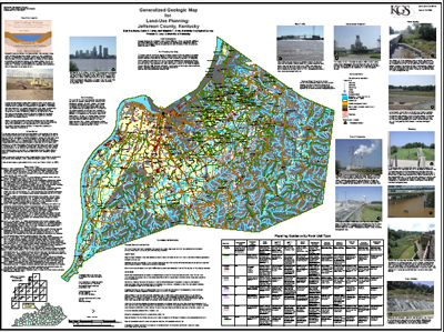
“These maps were created to provide planners, developers and others with enough information to enable them to ask the right questions before they start building,” says Dan Carey, a hydrologist at the Survey and chief manager of the project. “The original geologic maps may have depicted over two dozen types of rock formations. But for these maps the geology has been ‘generalized' into the major rock types affecting development so the non-scientist can understand them.”
In addition, features like sinkholes, faults, wetlands, and water, oil and gas wells are on the maps so someone who is considering building in a particular area can see if geologic issues could impede site development or cause later damage.
“Additional information can be added to each map easily,” says Bart Davidson, a KGS hydrogeologist also involved in the project. “ Kentucky is the one of the few states with detailed digital geologic mapping statewide. So the map files can be improved digitally and the data on the map upgraded pretty easily.”
Each of the large full-color maps includes photos and text about issues of concern such as landslides, karst landscape, flooding, abandoned mines and other geologic hazards.
Carey hopes the maps will be used for wise development.
“I want any citizen who is planning any kind of land use to be able to look at these maps and see what kind of rocks are there and what problems there might be so that if there are potential problems they'll know in advance and they can get a professional to help them.”
Carey has enlisted the assistance of some private professional geologists in the development of the maps of their home counties.
Each map includes a text section called “Planning Guidance by Rock Unit Type,” which briefly discusses the characteristics of each major type of geologic formation in the County and how each formation may handle various types of development.
The maps are available for $10 each from the KGS Public Information Center on the UK campus. Each map can also be viewed online at the Survey's web site: https://kgs.uky.edu/kgsweb/download/geology/landuse/lumaps.htm.