
The Kentucky Geological Survey has archived this material, meaning (1) it is for reference, research, or recordkeeping; (2) it was created before April 24, 2026; (3) and the material has not been changed or altered since being archived. Please refer to our KGS Accessibility page for more information.
KGS Home > News and Announcements
Two Coal Maps Published by the Kentucky Geological Survey
Lexington, Ky. (January 25, 2011)—After years of decline, coal production in the Western Kentucky Coal Field began to increase beginning around 2004 as a result of greater demand for coal found there and throughout the Illinois Basin. New and proposed mine openings in Union and McLean Counties in western Kentucky suggest this trend will likely continue.
As a result, the Kentucky Geological Survey, a research center at the University of Kentucky, has recently published maps depicting data on the two coal beds that will supply almost all of this increased production. The maps contain new assessments of coal thickness and extent, locations of active and historical mines, and estimates of remaining resource for the two coals, the Springfield (W. Ky. No. 9) and Herrin (W. Ky. No. 11). Each map includes tables listing active mine production and outlines of mined areas, as well as information on the thickness of the remaining coal and its proximity to the mine, transportation, and power infrastructure.
“The demand for these two coals has been on the rise for coal-fired power plants in the past few years because of their sulfur content and low mining cost relative to Appalachian coals,” says KGS Associate Director Jerry Weisenfluh, who prepared both maps. “Their sulfur levels are desirable for the increasing number of power plants with sulfur-reduction capacity, since they can remove most of the sulfur dioxide produced when the Springfield and Herrin coals are burned.”
The maps are titled “Remaining Resources of the Springfield Coal” (Map and Chart 197, Series 12) and “Remaining Resources of the Herrin Coal” (Map and Chart 198, Series 12). Each map can be viewed and downloaded for no cost on the KGS Web site or purchased in a printed form from KGS.
Weisenfluh estimates there were originally 10 billion tons of the Springfield coal in the Western Kentucky Coal Field, and 7.5 billion tons remain. Because some of this coal lies below more than 1,000 feet of overburden, 6.7 billion tons of the Springfield is considered mineable by today’s methods. Of the original estimated 5.2 billion tons of the Herrin coal, 3.8 billion tons remain, virtually all of which is considered mineable.
This and much more information on each of these important coals is available on the new maps.
To view or download the maps online, go to the KGS Publications and Map catalog at kgs.uky.edu/kgsweb/findpubsmain.asp. Enter the publication’s number, 17470 for the Springfield coal or 17492 for the Herrin, in the box next to “Enter Publication Number or SkuCode,” and to the right of this box select "exact publication id" from the pull-down menu. Clicking on the “Search” button opens a new page with a link to the map.
Paper copies of the 31.5 by 21.5 inch maps are available from the KGS Public Information Center for $10 each plus shipping and may be ordered by calling (859) 257-3896 or toll free at (877) 778-7827.
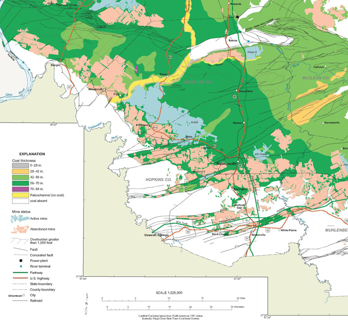
Detail of a section of the map, Remaining Resources of the Springfield Coal,
showing coal thickness, active and abandoned mines, and other features on the map.