
The Kentucky Geological Survey has archived this material, meaning (1) it is for reference, research, or recordkeeping; (2) it was created before April 24, 2026; (3) and the material has not been changed or altered since being archived. Please refer to our KGS Accessibility page for more information.
KGS Home > News and Announcements
Kentucky Geological Survey Community Engagement
 Geologic Data for the Commonwealth
A wealth of geologic information is available to citizens of Kentucky at no cost, 24 hours a day. KGS is the official repository for petroleum well and groundwater information, and also hosts a variety of other databases that relate to energy, mineral, and water resources. Thousands of persons access these data to determine, for example, whether oil or gas wells have been developed on a particular parcel or to determine the characteristics of coal beds on an inherited property. The most complete set of detailed geologic maps in the nation is also available to help answer questions about resources or the character of the land you live on. The data are easy to find and access on the Web site, and staff are available to answer questions about them.
Search for geologic data and publications at https://kgs.uky.edu/kgsweb/main.asp
 Water Supply and Quality
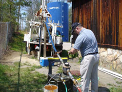
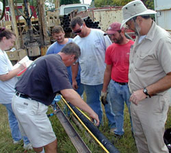
KGS professionals help identify new public water supplies for communities, particularly in eastern Kentucky. Evarts and Wallins (Harlan County), Campton (Wolfe County), and Hindman (Knott County) in the Eastern Kentucky Coal Field have benefited from such efforts. A number of high-yield water wells have been drilled as a result of research into delineating fracture systems that increase the flow of water above normal rates in the region. Studies have also been done to assess the use of water from abandoned underground coal mines.
KGS has participated in some important research on the relationship between groundwater quality and the health of those who use it for drinking and other domestic purposes. Working with the University of Kentucky’s College of Public Health and the Kentucky Water Resources Research Institute, KGS has monitored private water wells, and families have been surveyed in the Jackson Purchase Region of western Kentucky for such research.
More information about water research across the state at https://www.uky.edu/KGS/water/research
 Recognizing and Mitigating Geologic Hazards
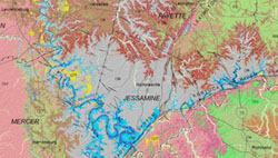
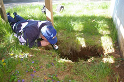
Kentuckians are faced with a variety of geologic hazards that can result in property damage and injury. The most pervasive are sinkholes that form on limestone bedrock occurring over half of the state. KGS geologists conduct extensive field investigations to document these features and track the flow of surface water into them through underground cave passages. These data are critical for community planners, developers, and homeowners who live in karst areas. Jim Currens received a University of Kentucky Commonwealth Collaboratives award to write a model local ordinance guiding development on karst terrain and to promote its adoption by local Kentucky governments.
Landslides are prevalent in northern and eastern Kentucky. KGS geologists visit landslides around the state to determine their origin and assess the potential for further movement. A new research project is under way to analyze maintenance costs related to geologic hazards along Kentucky’s highways.
Seismic hazards from earthquakes are possible in some parts of the state, but predicting the timing and magnitude of those events is challenging. UK seismologists monitor seismic activity recorded by 28 seismic stations in the Kentucky Seismic and Strong-Motion Network. This information will help develop seismic hazard maps to help policy-makers develop reasonable building codes for affected areas.
More information about geologic hazards in Kentucky at https://www.uky.edu/KGS/geologichazards/index.htm
and Generalized geologic county maps for land-use planning
 Assessing Energy Resources
The demand for energy has made Kentucky’s coal and other energy resources important commodities for both the state and the nation. KGS has been doing research on how to keep coal a viable energy source by permanently storing carbon dioxide released by coal-fired power plants in deep geologic formations. State and Federal funds are also being used to research the possibility of using carbon dioxide to force additional oil and gas out of depleted reservoirs in the state. Staff in the Energy and Minerals Section are also looking into the possibility that methane trapped in coal beds could be an economic energy resource and whether the Rough Creek Graben of western Kentucky may be a source of future oil and gas supplies.
More information on research into carbon dioxide storage
https://www.uky.edu/KGS/kyccs/
More information on coalbed methane research
https://www.uky.edu/KGS/emsweb/cbm/
More information on enhanced oil and gas recovery research
https://www.uky.edu/KGS/kyccs/eoregr.html
As a service to Kentucky’s science teachers, the KGS Web site includes a link to the Earth Science Education Network, which has resources to help educators with topics addressed in the Kentucky Earth Science Core Content and national science education standards. Classroom activities in the earth sciences, popular Kentucky earth science publications, and other useful resources can be accessed through the Web site.
More information about the Earth Science Education Network
https://www.uky.edu/KGS/education/index.htm
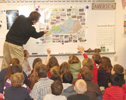 “Maps to Teachers” Puts Geologic Maps in Kentucky Classrooms
When the KGS map series Generalized Geologic Maps for Land-Use Planning was developed, it was intended to help nongeologists understand the geology of the places where they live, work, and play and avoid damages from geologic hazards. Maps were completed for each of Kentucky’s 120 counties and copies of the maps were offered to teachers for classroom use. The response was overwhelmingly positive and inspired the subsequent Maps-to-Teachers publication series that offers the maps for classrooms and libraries in all Kentucky schools. Hundreds of teachers now have these maps in their classrooms across Kentucky.
More information about available maps and posters
https://www.uky.edu/KGS/announce/landuse_teacher.htm