
What do you typically look for on a piece of property you’re considering buying to build a new home or develop for a business site? The property’s geologic conditions may not be high on your list, but ignoring the geology-particularly on hillsides in the Greater Cincinnati Tri-state area—could lead to serious consequences after the property is developed. The hillsides in this region create picturesque views, but they are also prone to instability in the form of landslides.
Greater Cincinnati is among the most active areas in the country for landslides, which can damage homes, businesses, streets, and utilities. To help people recognize landslide conditions and avoid costly damages, the geological surveys of Indiana, Kentucky, and Ohio have collaborated with the University of Cincinnati Geology Department to produce a detailed fold-out pamphlet about the region’s landslide conditions. Duke Energy provided funding to print the pamphlet, titled "Landslides and Your Property."
To make it useful for nontechnical people, the pamphlet uses plain language, supplemented with a glossary explaining technical terms. Graphics depict and help explain types of landslides and soil creep, and photos show examples from the area. A section in the pamphlet also describes the related problem of swelling soils in the region, which can damage structures even on flat terrain.
The publication provides guidance on looking for landslide evidence when considering a property for development. Cracks or depressions in the soil and tilted trees or utility poles may be signs that the soil is unstable. Consulting geologic and soil maps of the area can also provide hints that development might be risky without thorough geotechnical investigation, testing and mitigation.
Steps to take to reduce landslide risks are also included, such as controlling drainage, keeping deep-rooted vegetation, and carefully placing buildings on a property prone to sliding.
Information on private organizations and government agencies that can provide landslide assistance, geologic maps, or soil data for the region is also provided in the publication. It folds to a handy pocket-sized 4 x 8 inches. It unfolds to 28 by 16 inches.
Folded, ready-to-use paper copies of "Landslides and Your Property" are available from the KGS Public Information Center on the UK campus for $4.00 each. They may be ordered by calling (859) 257-3896, or toll free at (877) 778-7827, and asking for publication # 17740.
A low-resolution version of the publication can also be viewed at the KGS Web site here http://kgs.uky.edu/kgsweb/olops/pub/kgs/LandslidesBrochure.pdf.
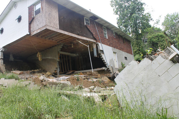
A landslide caused severe damage to this Boyd County, Ky. home,
which had to be abandoned by its owner.