
KGS Home > News and Announcements
Western Kentucky Fluorspar District Map Published by KGS
A new map of the Western Kentucky Fluorspar District has been published by the Kentucky Geological Survey (KGS) at the University of Kentucky. Mines and minerals of the Western Kentucky Fluorspar District (Map and Chart 201, Series XII, 2012) shows all the known mines, mineral prospects, and igneous intrusions (dikes or sills) of the Western Kentucky Fluorspar District, that includes Caldwell, Crittenden, and Livingston Counties. The map, released in late December as a geospatial PDF file, is now available for free download at the KGS Web site or as a 36 x 49-inch printed on-demand map for $10 plus shipping. (Please note that the PDF file requires Acrobat 9 or higher for full geospatial functionality.)
This map was compiled from numerous in-house, donated, and loaned maps and files, creating an up-to-date, comprehensive catalog for the district. "The district has been extensively mined for more than 120 years and was once the largest producer of fluorspar (fluorite) in the United States," says lead map author Warren Anderson, of the KGS Energy and Minerals Section. "Millions of tons of vein ore minerals, including fluorite, zinc, lead, and barite, have been produced from these mines."
Recent mining and exploration activity has renewed interest in the district, and the mineral industry will benefit from the publication of this map. In addition, the identified igneous rocks have the potential to host rare earth elements, an increasingly important strategic resource. Mineral specimen collectors and anyone wishing to locate sites of historic mining activity may also find the map of interest.
"This map also serves as an introduction to a new map service for mineral data being developed on the KGS Web site, anticipated for early 2013," says co-author Tom Sparks of KGS. This online map service will encompass many of the non-coal minerals in Kentucky (e.g., fluorite, barite, galena, sphalerite, iron, titanium, nitrate, sulphate, and phosphate). "Spatial database and general tabular information such as site name, quadrangle, or coordinates, can be queried from the interactive map," Sparks adds. In addition, available scanned data of surface maps, underground mine maps, property lease maps, field notes, drill logs, cross sections, summary reports, and reserve studies can be accessed, viewed, and downloaded.
To view and download the map, go to this Web site, http://kgs.uky.edu/kgsweb/olops/pub/kgs/MC201_12.pdf. To order a paper copy of the map, call the KGS Publications Sales Office at (859) 257-3896, or toll-free at (877) 778-7827.
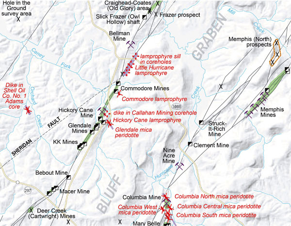
Detailed view of a section of Mines and minerals of the Western Kentucky Fluorspar District