
KGS Home > News and Announcements
New Geologic Map of Kentucky Published by the Kentucky Geological Survey
Lexington, Ky. (October 20, 2009)—A new publication, the Geologic Map of Kentucky, now available from the Kentucky Geological Survey (KGS) at the University of Kentucky, compiles over 700 digital maps to make up the full geologic map of the state. It can be downloaded from the KGS Web site or purchased in paper form and laminated. This colorful 1:350,000-scale map includes all major geologic formations of the state, along with major surface faults, counties, county seats, streams, and rivers. The 36 x 80 inch map was created from 707 U.S. Geological Survey-minute geologic quadrangle maps (scale 1:24,000) that were digitized during the KGS Digital Geologic Mapping Program (1996 – 2006).
“This publication encapsulates the original mapping done during a cooperative project by the USGS and KGS from 1960 to 1978, when Wally Hagan was state geologist,” says Tom Sparks of the KGS Geospatial Analysis Section. From 1996 to 2006, using funding from the STATEMAP Program of the USGS National Cooperative Geologic Mapping Program, KGS staff digitized and compiled the previously published 707 geologic quadrangle maps into a seamless map.
“Just about anyone interested in the general geology of Kentucky, as well as educators and students of geology will find the map useful and interesting.” Sparks points out that a long list of people contributed to the program and the map, including KGS project staff, visiting scholars, students, volunteers, and summer interns.
The publication illustrates regional changes in stratigraphic nomenclature (proper geologic names and their associated characteristics within the rock record) that arise from lateral variations in the rocks but may also be due to evolving nomenclature usage during and after the original mapping program. While compiling the maps, every effort was made to resolve inconsistencies in the formation names, to adopt more recent usage, and edgematch adjoining maps. The end result is a map that uniquely combines the fidelity of large-scale maps with the regional perspective of a statewide compilation to illustrate the achievements of the KGS Digital Geologic Mapping Program.
Visitors to the KGS web page can view and download the map by going to the KGS Publications & Map catalog at http://kgs.uky.edu/kgsweb/findpubsmain.asp. Enter this publication’s number, 17283, in the box next to “Enter Publication Number or SkuCode”. Clicking on the “Search” button opens a new page with a link to the map. The Adobe PDF file is over 16 megabytes in size but it is a high quality resolution plot file with detail in both the geology and hillshading displayed. Its download and online viewing time may vary, depending on the user’s internet access speed. In addition, printing times on plotters may be long due to the size and details of the digital file.
Paper copies of the map are available from the KGS Public Information Center on the UK campus for $10 each plus shipping. They may also be laminated for an extra charge. To order a copy, call (859) 257-3896 or toll free at (877) 778-7827. The digital data, for use in GIS software, for each of the 707 quadrangle maps are available from the Public Information Center under the KGS DVGQ series. Quadrangle datasets are also $10 each.
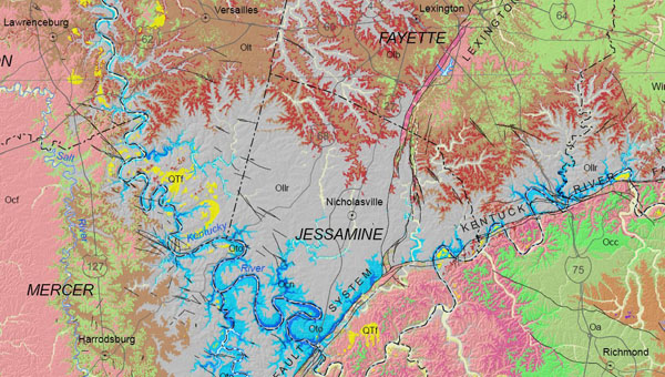
Section the Geologic Map of Kentucky showing details of the Central Kentucky area.