
KGS Home > News and Announcements
More Geologic Maps Released by KGS
Lexington, KY. (March 9, 2010) - Staff at the Kentucky Geological Survey have now completed and published 17 in a series of 30 x 60 minute geologic quadrangle maps of parts of Kentucky at a scale of 1:100,000. Each of these maps is the result of detailed assembly of 7.5-minute geologic quadrangle maps, converted from their original paper versions to digital files known as Digitally Vectorized Geologic Quadrangle (DVGQ) maps. Kentucky is geologically mapped at a scale of 1:24,000, by a total of 707 of these 7.5-minute geologic quadrangle maps.
The two most recent maps in the series are “Geologic Map of the Tell City and Part of the Jasper 30 x 60 Minute Quadrangles, West Central Kentucky” (Publication # 17263), created by Matt Crawford, and “Geologic Map of the Williamson and Part of the Beckley 30 x 60 Minute Quadrangles, Eastern Kentucky” (Publication # 17396) done by Mike Murphy. Terry Hounshell of KGS did the cartographic work for the final versions of the maps. Each publication includes the detailed geologic map itself and a description of the major mapped geologic formations. Counties, cities and major roads are also depicted in the mapped area. The accompanying text on economic geology, water resources, geologic hazards, and other features make these maps useful for community planners, energy industries and others interested in the geologic resources of the mapped areas.
For instance, the Eastern Kentucky map discusses the 56 known coal beds in the mapped area, 33 of which have been commercially developed. The map, compiled from 27 DGVQ’s, also notes the high susceptibility of the area to landslides, due to the type and thickness of the soil and the steep colluvial slopes of the region.
The map of West Central Kentucky includes text describing the economic geology of the region, including limestone, oil, gas, coal, clay, sand, and gravel, giving some history and production data for some of the resources. In addition, useful information on the structural geology, hydrogeology, and engineering geology of the region are included.
The digital vector files used to create these maps are also available from KGS on CD-ROM for $10 per individual DVGQ and can be used in geographic information systems (GIS) and other computer software. The digital data sets allow GIS users to combine the geologic map data with other data for multiple purposes, including geologic hazard mitigation and assessment of energy and mineral resources. The digital data sets can also be used to create custom maps; they are very useful for land-use development and planning.
To view the 30 x 60 minute geologic maps online, go to the KGS Publications & Map catalog at http://kgs.uky.edu/kgsweb/findpubsmain.asp. Enter the publication number in the “Publication Number or Sku Code” box, and select "exact publication id" from the pull down menu. Clicking on the “Search” button opens a new page with a link to the map.
Paper copies of the maps are available from the KGS Public Information Center on the UK campus for $10 each plus shipping and may be ordered by calling (859) 257-3896 or toll free at (877) 778-7827.
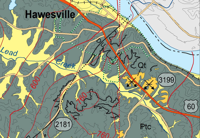
Detail of a section of the Geologic Map of the Tell City and Part of the Jasper 30 x 60 Minute Quadrangles, West Central Kentucky.