
KGS Home > News and Announcements
Map of Kentucky Terrain Published by Kentucky Geological Survey
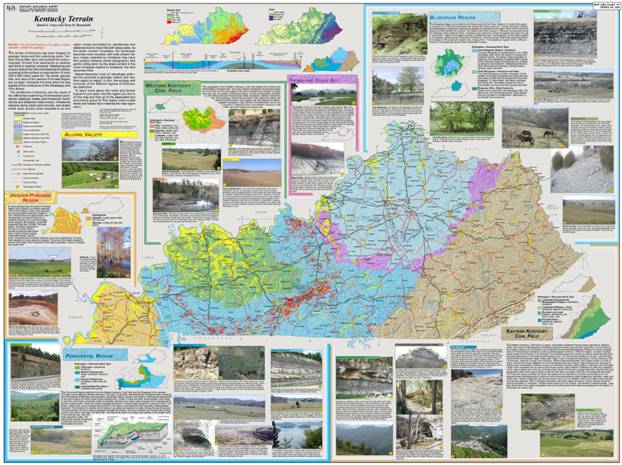
The topography and landforms in Kentucky vary widely across the state. There are a number of distinct regions. Kentucky Terrain, a 43 x 33-inch illustrated map by Dan Carey and Terry Hounshell explains this variety and describes the regions using maps, photos, diagrams, and text.
The map was created to help educators, students and the general public gain a better understanding of the geology of Kentucky and how the rocks beneath our feet shape the land and how we use it.
From the map:
“The terrain of Kentucky has been shaped by geologic forces and the underlying rocks. Tectonic forces lifted, bent, and buckled the rocks—originally formed from sediments on shallow sea floors. Weathering and erosion shaved the hills and dissected the plains, exposing at the surface a cross-section of rocks 250–500 million years old. The sands, gravels, silts, and clays of the Jackson Purchase are younger, remnants of a time when the sea lapped at the confluence of the Mississippi and Ohio Rivers.
The landforms in Kentucky are the result of the differential weathering of interbedded sandstones, siltstones, shales, and limestones. Sandstones and siltstones resist erosion, limestones dissolve along cracks and crevices, and shales break down quickly when exposed to air and water. Areas dominated by sandstones and siltstones tend to have hills with steep sides. As the shale content increases the landscape becomes more rounded, with wide stream valleys. Areas underlain by limestone may have few surface streams (karst topography) and gently rolling land. As the shale content in the rocks increases relative to limestone, the land becomes hillier.
The natural resources—coal, oil, natural gas, soils—are the products of geologic history and vary from region to region. In turn, the ecology and economy of the different regions of Kentucky are distinctive.”
“We describe the geology for each region, how the terrain is shaped by the geology, and how geology may impact recreation or the economy.” says Carey.
“As you travel across the state, you can’t help but notice how the landscape changes,” says Hounshell, KGS cartographer and the map’s co-author. “This map tries to help explain why.”
To view and download this publication on-line, Click Here.
Copies of the map are available from the KGS Public Information Center on the UK campus for $10 each plus shipping and may be ordered by calling (859) 257-3896 or toll free at (877) 778-7827.