KGS Home > News and Announcements
Interactive Kentucky Energy Infrastructure Map Service Now Available
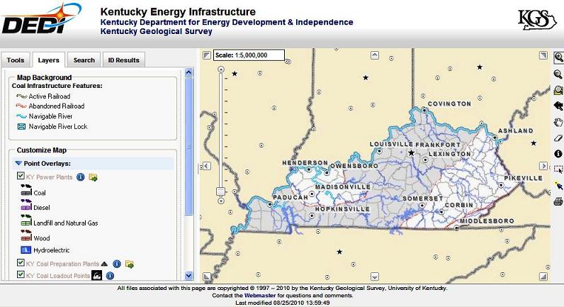
Lexington, Ky. (August 25, 2010)—People interested in Kentucky energy issues will find a new web-based service invaluable for quickly finding the locations of power plants, railroads, active coal mines, and other coal processing, handling, and transportation facilities in Kentucky.
The Kentucky Department for Energy Development and Independence and the Kentucky Geological Survey (KGS) have joined to develop an interactive web map titled “Kentucky Energy Infrastructure.” The map service, created with funding from the Kentucky Coal Education grant, can be found at http://kgs.uky.edu/kgsmap/KYCoal/viewer.asp.
There have been earlier printed versions of this map, but with the typical limitations of a paper map, such as fixed scale and content. The new version adds dynamic characteristics available only through a web-based resource. All data shown on the map can be downloaded in both spreadsheet and GIS format for use on a local computer.
Associate State Geologist Jerry Weisenfluh, along with Doug Curl and Cortland Eble of KGS, worked to gather the information and produce the final service at the web site.
“The Energy Infrastructure map is ideal for getting an overview of coal mining, processing, and utilization infrastructure in Kentucky,” says Weisenfluh. “All of the facilities in that infrastructure are important to the state’s energy needs, as Kentucky derives more than 90% of its electric power from coal.”
The map service includes tools which allow a user to select a defined area, choose a level of detail, and click on mapped items, such as power plants, mines and coal-related facilities, to see information on the particular feature.
“The new interactive web map effectively brings to a close the era of printed maps and allows us to join the 21st century with greater access, accuracy and information about our energy and coal resources,” said Len Peters, Energy and Environment Cabinet Secretary. “The dynamic scalability, GIS interface and connectivity to other data bases is outstanding. KGS has done a very nice job.”
Updated data will be added to the service as it becomes available, and links to external Web sites to obtain other information for an area of interest adds to the value of the site.
For those not familiar with using this type of web service, a “How to use this service” link in the lower left margin of the opening page opens a service tutorial.