KGS Home >
Oil and Gas
Geology, Hydrocarbon Production, and Horizontal Drilling in the Upper Devonian Berea Sandstone, Eastern Kentucky: References and Data Resources
Compiled by David Harris, Kentucky Geological Survey, June 2013.
The Berea Sandstone has been a major producer of natural gas in eastern Kentucky for decades, but recent horizontal drilling activity in northeastern Kentucky has generated new interest in this reservoir interval. In this area, the Berea produces oil in addition to gas due to the lower thermal maturity of the adjacent source rocks. Horizontal drilling combined with hydraulic fracturing technology have been successful in enhancing oil production rates compared to older vertical wells. The references and data sources linked below are provided to assist oil and gas operators in understanding the geology and hydrocarbon potential of the Upper Devonian Berea Sandstone, with particular emphasis on the emerging horizontal oil play.
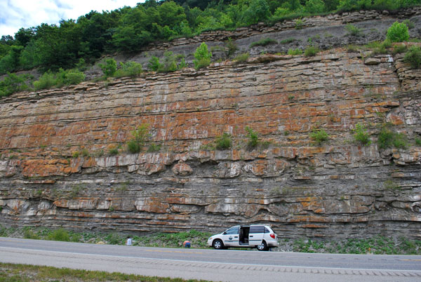
Berea Sandstone outcrop on Ky. Highway 10, south of Garrison, Kentucky (Lewis County)
showing characteristic ball and pillow structures in thinner siltstone and shale beds.
Latitude 38.59843, Longitude -83.172544, Photo by Cortland Eble, KGS.
Links to resources outside the Kentucky Geological Survey will open in separate windows.
Click here to download the proposal. Response Deadline April 11, 2014
Click to download a spreadsheet of porosity and permeability data
- Greb, S.F., Harris, D.C., Parris, T.M., Eble, C.F., and Nuttall, B.C., 2014, Update on the Berea Sandstone Oil Play in Kentucky, Ohio Oil and Gas Association Annual Meeting, Columbus, OH, Nov. 13, 2014 (updated and slightly different than the talk at KOGA)
- Greb, S.F., Harris, D.C., Parris, T.M., Eble, C.F., and Nuttall, B.C., 2014, Update on the Berea Sandstone Oil Play in Kentucky, Kentucky Oil and Gas Association Annual Meeting, Louisville, KY, July 16, 2014
- Harris, D.C, 2014, Berea Sandstone Horizontal Oil Play, Eastern Kentucky, Appalachian Geological Society Meeting, Marshall University, March 12, 2014
- Harris, D.C., 2013, Geology of the Berea Horizontal Oil Play, Eastern Kentucky: Kentucky Oil and Gas Association Spring Quarterly Meeting,
Jenny Wiley State Park, April 24, 2013
- Pancake, J.A., McCallum, S., and Zinn, C., (date
unknown), Development of Non-Shale Reservoirs in the Appalachian Basin
using Horizontal Drilling Techniques, Pittsburgh Association of Petroleum Geologists.
Abstract: Horizontal drilling has been in existence for
many years, however, it has only recently gained greater acceptance as the
preferred method for development of shale reservoirs in the Appalachian
basin. The success of this technique in shale intervals has led to greater
interest in it's applicability as a development method in non-shale
reservoirs. Equitable Resources has recently used horizontal drilling to
target traditional non-shale reservoirs and previously overlooked gas prone
horizons. This technique has the potential to rejuvenate mature or heavily
developed non-shale reservoirs using infill and reduced spacing techniques.
This paper examines the geologic setting and characteristics of various
non-shale reservoirs in the Appalachian Basin and reviews the development
strategy employed by Equitable to unlock or enhance the production from
these reservoirs.
- Morris, J. and others, (date unknown), Horizontal
Development in the Appalachian Basin Devonian Section, Pittsburgh Association of Petroleum Geologists.
Abstract: Equitable Resources began a horizontal drilling pilot project in mid-2006, initially targeting the Lower Huron Shales in eastern KY. Equitable has drilled over 170 horizontal wells in this play, expanding the project into adjacent states and also targeting additional Devonian Shale zones and some non-shale reservoirs. Techniques such as multi-lateral drilling were also tested. This paper examines the results of this program, including the geologic setting of the target zones, the development strategy utilized by Equitable, and some of the results to date.
- Frantz, Jr., J. H., and Lancaster, D.E., 1993,
Reservoir engineering and treatment design technology, research results from
the Ashland Exploration, Inc., Ford Motor Co. 80 (COOP 2) Well, Pike County,
KY: GRI topical report GRI-94/0258.1, 165 p. (Available from the National Technical Information Service)
- Frantz, J.H., Guidry, K., Luffel, D., and Kubik,
West, 1993, Evaluation of the Berea Sandstone Formation in Eastern Pike
County, Kentucky (abst.): Am. Assoc. of Petroleum Geologists Bull., v. 77,
no. 8, p. 1468. (link)
- Hauser, R.E., 1953, Geology and Mineral Resources of the Paintsville (15-Min.) Quadrangle, Kentucky: Ky. Geological Survey Series IX, Bull. 13, 80 p. (PDF, check "View pocket/figure information" link for maps)
- Milici, R.C. and Swezey, C.S., 2006, Assessment of
Appalachian Basin Oil and Gas Resources: Devonian Shale-Middle and Upper
Paleozoic Total Petroleum System, Open-File Report Series 2006-1237 (link)
- Nolde, J. E., and Milici, R. C., 1993,
Stratigraphic and structural controls of natural gas production from the
Berea Sandstone (Mississippian), southwestern Virginia (abst.): American
Association of Petroleum Geologists Bulletin, v. 77, no. 8, p.
1471-1472. (link)
- Pashin, J.C. and Ettensohn, F.R, 1995,
Re-evaluation of the Bedford-Berea Sequence in Ohio and Adjacent States:
Forced Regression in a Foreland Basin, GSA Special Paper 298, 68 p. (link)
- Pashin, J.C., and Ettensohn, F.R., 1987, An epeiric
shelf-to-basin transition: Bedford-Berea sequence, northeastern Kentucky and
south-central Ohio: American Journal of Science, v. 287, p. 893-926.
- Pepper, J. F.; de Witt, Wallace, Jr.; Demarest, D.
F., 1954, Geology of the Bedford shale and Berea sandstone in the
Appalachian basin, USGS Professional Paper 259, 111 p., 13 plates. PDF, High-resolution map scans)
- Pepper, J. F., and de Witt, Wallace, Jr., 1946, Map
of the Berea sand in southern Ohio, eastern Kentucky, and southwestern West
Virginia, U.S. Geological Survey Oil and Gas Investigations Preliminary Map
69. (link)
- Potter, P.E. and Maynard, J.B., 1982, Lithologic and environmental atlas of Berea sandstone (Mississippian) in the Appalachian Basin: first annual report, 1 Sept. 1981 to 1 Sept. 1982: GRI Contract 5081-321-0485, 26 p.
- Potter, P.E. and Maynard, J.B., 1983, Lithologic
and environmental atlas of Berea (Mississippian) sandstone of Appalachian
Basin: second annual report, 1 September 1982 to 1 September 1983: GRI
Contract 5081-321-0485, 96 p. (link)
- Thomas, G.R., and Lauffer, J.B., 1964, Completion
techniques and results of recent Berea sand development in Pike County,
Kentucky: in McGrain, P, Wilson, E.N., and Crawford, T.J. (eds.),
Proceedings of the Technical Sessions Kentucky Oil and Gas Association 26th
and 27th Annual Meetings, 1962 and 1963, Kentucky Geological Survey Series
10, Special Pub. 8, p.83-89. (PDF)
- Tomastik, T.E., 1996, Play MDe: Lower Mississippian - Upper Devonian Berea and equivalent sandstones, in Roen, J.B., and Walker, B.J., eds., The Atlas of Major Appalachian Gas Plays: West Virginia Geological and Economic Survey Publication V-25, p. 56-62.(PDF)
- Elam, T.D., 1981, Stratigraphy and
paleo-environmental aspects of the Bedford-Berea Sequence and the Sunbury
Shale in Eastern and South-Central Kentucky: MS thesis, University of
Kentucky, 155 p. (PDF, 45MB)
- DeReamer, J., 1984, An environmental interpretation
of the Berea Sandstone formation (Lower Mississippian) in south-central
Ohio, northeastern Kentucky and adjacent West Virginia : an outcrop, core
and subsurface study: MS thesis, University of Cincinnati.
- Pashin, J.C., 1990, Reevaluation of the Bedford-Berea sequence in Ohio and adjacent states: New perspectives on sedimentation and tectonics in foreland basins: PhD thesis, University of Kentucky, Lexington, 412 p.
(These KGS Open-File Reports include oversize plates. Please use the "View Pocket/Figure Information" link to download the separate plates.)
- Avila, John, 1983, Area requested for tight
formation designation in the Berea Sandstone, Pike County, Kentucky:
Kentucky Geological Survey, Series 11, Open-file Report 83-0001, 100p. ( link)
- Avila, John, 1983, Areas requested for tight
formation designation of the Berea Sandstone in Lawrence County, Kentucky:
Kentucky Geological Survey, Series 11, Open-file Report 83-0002, 53p. ( link)
- Potter, P.E., Ausich, W.I., Klee, J., Krissek, L.A., Mason, C.E.,
Schumacher, G.A., Wilson, R.T., and Wright, E.M., Geology of the Alexandria-Ashland
Highway (Kentucky Highway 546), Maysville to Garrison (Guidebook and
Roadlog for Geological Society of Kentucky 1991 Field Conference): Kentucky
Geological Survey, Series 11, Guidebook 52, 64 p.
( link)
- East, J.A., Swezey, C.S., Repetski, J.E., and
Hayba, D.O., 2012, Thermal maturity map of Devonian shale in the Illinois,
Michigan, and Appalachian basins of North America: U.S. Geological Survey
Scientific Investigations Map 3214, 1 sheet. (link)
- Rimmer, S.M., Cantrell, D.J., and Gooding, P.J.,
1993, Rock-eval pyrolysis and vitrinite reflectance trends in the Cleveland
Shale Member of the Ohio Shale, eastern Kentucky: Organic Geochemistry, v.
20, no. 6, p. 735-745.
- Rimmer, S.M. and Cantrell, D.J., 1988, Organic
Maturation of the Cleveland Member of the Ohio Shale (Eastern Kentucky):
Proceedings 1988 Eastern Oil Shales Symposium, Univ. of Kentucky Institute
for Mining and Minerals Research, p.401-410. (link)
- Ryder, R.T., Hackley, P.C., Alimi, H., and Trippi, M.H., 2013, Evaluation of thermal maturity in the low maturity Devonian shales of the northern Appalachian Basin: Search and Discovery article #10477 (18MB): http://www.searchanddiscovery.com/documents/2013/10477ryder/ndx_ryder.pdf Data and appendices are also available here (59MB): http://www.searchanddiscovery.com/documents/2013/10477ryder/appendices
(These
links will return lists of permitted horizontal wells in the specified
counties with significant Berea activity. Some of these wells have scanned
documents and logs available for viewing after installation of the DjVu
browser plug-in. Note that horizontal wells included in the results may
include target formations other than the Berea. The selected wells can be
mapped by clicking the "Map Results on Geologic Map Service" button.)
