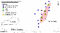
Homer Field Map
Exploration for natural gas in the Appalachian Basin is continuing to probe deeper stratigraphic horizons. Recent discoveries include the Homer Field, which produces from the Cambrian Rome Formation in Elliott County, Kentucky, and the Cottontree Field in Roane County, West Virginia, which produces from the Ordovician Trenton Limestone.
To better understand the deep Cambrian reservoirs, a research consortium was formed in late 1998 to conduct a 2-year study of the pre-Knox stratigraphic interval in Kentucky, West Virginia, and Ohio. The research was being conducted by the Kentucky, West Virginia, and Ohio geological surveys, and was funded by four energy companies and the U.S. Department of Energy. This project focused on the Rome Trough, a graben that contains a thickened section of the Rome and Conasauga Formations. Additional information on the Rome Trough can be found in several KGS publications.
During the first year of the project, 13 regional cross sections were constructed using over 100 digitized geophysical well logs. Both structural and stratigraphic sections were built to define stratigraphic correlations within the Rome Trough. This framework was then used as a reference to collect stratigraphic data for 761 Knox and deeper wells in the study area. These data were compiled into a computer database. Additional work involved sampling of gas and condensate oil from the Homer Field in conjunction with the United States Geological Survey (USGS). The USGS will be conducting geochemical analyses on these samples to determine the source of the hydrocarbons.
During the second year of the project, depositional facies were interpreted, based on core descriptions, and sandstone trends were mapped. These data have been incorporated into an exploration model for the Rome Trough play. More details on this project can be found in the original project proposal. [Proposal is a PDF document requiring Adobe Acrobat Reader.]
Data from this project is proprietary to the funding companies for 2 years and will be released in 2004. For currently available Rome Trough data, see the links below.
We plan to continue the deep basin research in with a new project for the consortium. For more information on participating in this new study, please see the proposal.
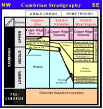
Nomenclature
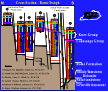
Cross Section

Sampling Natural
Gas