
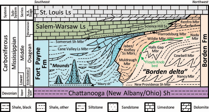
Figure 1. Stratigraphy of the Fort Payne Formation in south-central Kentucky.
Formations are colored to highlight mapped units (modified from Greb and others, 2008).
The Fort Payne Formation overlies the Late Devonian Chattanooga (New Albany) Shale or a glauconitic claystone called the Floyds Knob Bed (green in Figure 1). The Floyds Knob drapes abandoned delta lobes in the lower and middle Borden Formation (light orange in Figure 1). The Borden delta is formed by the New Providence, Nancy, Cowbell, Halls Gap, Nada (part), and Farmers (occurs in eastern Kentucky) Members of the Borden Formation (see for example, Peterson and Kepferle, 1970; Sable and Dever, 1990). The part of the Borden below the Floyds Knob Bed is diachronous, representing a series of prograding delta lobes (clinoforms). At least six progradational clinoform units have been identified in Kentucky and Indiana (Matchen and Kammer, 1984). The Borden delta prograded from east to west and stopped in south-central Kentucky just west of Lake Cumberland (Peterson and Kepferle, 1970).
The Fort Payne Formation filled the depositional basin west of the Borden delta front. The formation extends from Illinois into Alabama. In the western Lake Cumberland area, the Fort Payne Formation varies between 210 and 310 ft in thickness (Thaden and Lewis, 1962, 1966). The unit is as much as 600 ft thick in the subsurface of western Kentucky (Sable and Dever, 1990).
To the east, the majority of the Fort Payne Formation is equivalent to those parts of the Borden above the Floyds Knob Bed, including the Muldraugh, Harrodsburg, Nada (part), and Renfro Members (darker orange in Figure 1). Muldraugh siltstones interfinger downdip with carbonates and siltstones of the Fort Payne Formation, although they were mapped separately in most areas. The Harrodsburg Limestone Member is a carbonate at the top of the Borden in parts of central and north-central Kentucky and is partly equivalent to the Cane Valley Limestone Member of the Fort Payne Formation (Fig. 1). The top of the Renfro Member is the top of the Borden in eastern Kentucky. The Renfro Member is a dolomite that is equivalent to the Salem-Warsaw Limestone (above the Fort Payne Formation) and may include dolomites in the lower St. Louis Limestone. In parts of eastern Kentucky, the Renfro was removed from the Borden, and made a member of the Slade Formation, which includes the St. Louis Limestone and overlying carbonates.
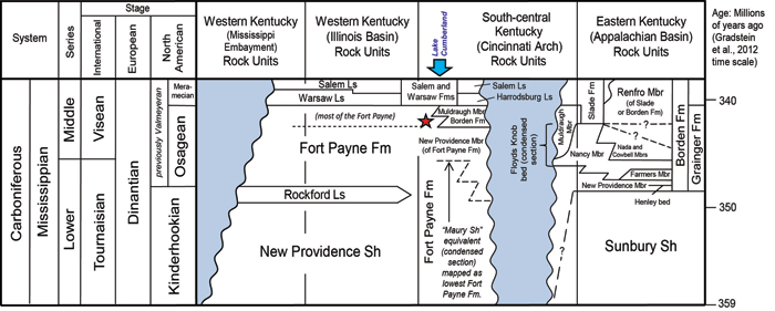
Figure 2. Correlations of the Fort Payne Formation and Lower to Middle Mississippian units across Kentucky. Shaded areas represent rock removed by erosion.
The star shows the approximate position of the mud mounds relative to geologic time. Fm=Formation, Gp=Group, Ls=Limestone, Mbr=Member, Sh=Shale.
Figure 2 shows correlations of the Fort Payne Formation across Kentucky plotted against geologic time. As mapped in the Lake Cumberland area, the Fort Payne Formation extends from the base of the Mississippian System (base of the Kinderhookian stage) to the base of the Warsaw Formation (Middle Mississippian, base of the Meramecian stage). The majority of the Fort Payne Formation (including the mud mounds) was deposited during the middle Mississippian (mid- to late Osagean stage; star in Fig. 2). One confusing aspect of the stratigraphy when plotted against time, is that the greatest length of time is represented by only a few feet of shale at the bottom of the unit. These shales are equivalent to the Maury Formation in Tennessee (see Figure 3).
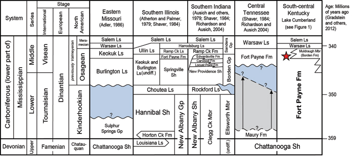
Figure 3. Regional correlations of the Fort Payne Formation in surrounding states.
The star in the Lake Cumberland column shows the approximate position of the mud mounds and overlying strata relative to geologic time.
Fm=Formation, Gp=Group, Ls=Limestone, Mbr=Member, Sh=Shale.
Figure 3 shows regional correlations of Lower Mississippian strata in the states surrounding the Lake Cumberland area plotted against geologic time. Correlations are updated from regional stratigraphic charts (Kepferle, 1977; Kammer and Lane, 1979; Patchen and others, 1984; Shaver and others, 1984; Adler, 1986; Ausich and Meyer, 1990). In general, the main part of the Fort Payne Formation as mapped in south-central Kentucky and north-central Tennessee is equivalent to the Ramp Creek Formation in Indiana and the Keokuk Limestone westward into the Illinois Basin and Midcontinent. These are Middle Mississippian (mid to late Osagean) in age, based on their invertebrate fauna (Butts, 1922; McFarlan, 1943; Meyer and others, 1997). The main part of the Fort Payne Formation (including the mud mounds) corresponds to the Gnathodus texanus-Taphrognathus conodont zone (Lane and others, 1980; Ausich and Meyer, 1990, Sable and Dever, 1990; Khetani and Read, 2002).
The lower part of the Fort Payne Formation (shale dominant) as mapped in Kentucky, is equivalent to the Maury Shale in Tennessee (Figs. 2, 3). The stratigraphic interval between the base of the Fort Payne mud mounds or sitltstones and the top of the Devonian Chattanooga Shale is generally less than 10 ft thick, and for practical purposes it did not make sense to map underlying units as a separate formation in south-central Kentucky. In other states, however, the upper mixed carbonate and clastic portion of this interval is mapped separately from the underlying shales. The lower shaley parts of the Mississippian section are variably mapped as the Hannibal Shale, part of the New Albany Shale or Group (which is restricted to the Devonian in Kentucky), or part of the New Providence Shale (as a member of the Borden or Fort Payne Formation) in surrounding states. The Maury and its equivalents are Lower to Middle Mississippian (Kinderhookian to mid-Osagean) in age (Sable and Dever, 1990; Richardson and Ausich, 2004), and correspond to the Siphonodella duplicata-Scoliognathus anchoralis conodont zone (Leslie and others, 1996; Khetani and Read, 2002). In Tennessee, the contact between the Fort Payne and Maury Formations is considered unconformable, and a considerable hiatus has been interpreted (Shaver, 1984). However, conodont (Leslie and others, 1996) and miospore research (Richardson and Ausich, 2004) in equivalent shales in southern Kentucky, indicate that the Maury extends upward into the mid-Osagean (near or to the top of the Tournasian, Fig. 2). Hence, the hiatus, if it occurs, is not as long as considered by past authors. Variability in how these units are mapped across the region complicates correlations. This part of the stratigraphic section is also confusing because the Maury and its equivalents may be only a few feet thick, but represent a much larger length of geologic time than the overlying 200 to 300 feet of mixed carbonates and clastics in the overlying (parts of the) Fort Payne Formation. The Maury and its equivalents represent a condensed section, which accumulated very slowly in the basin west of the Borden delta (Leslie and others, 1996; Khetani and Read, 2002; Richardson and Ausich, 2004).
The Borden units east of the Fort Payne Formation are mapped as a formation in Kentucky (Fig. 2), and as a group in Indiana (Fig. 3). Delta lobes in Indiana are different than in Kentucky. Named units within the lobes are different and the age of the lobes is different (Kepferle, 1977; Ausich and others, 1979). In general, Borden facies are time-transgressive. They are younger from east to west (Lane and Dubar, 1983) and north to south (Rexroad and Scott, 1964; Richardson and Ausich, 2004). In Figure 3 the age of the contact between the top of the Nada Member of the Borden and base of the Renfro Member is shown as questionable. Richardson and Ausich (2004) suggest the Nada and lower units of the Borden do not extend into the mid-Osagean (Visean) in northeastern Kentucky, but that the Nancy extends to the top of the Visean in south-central Kentucky. The overlying Renfro Member contains Middle Mississippian (Meramecian) Warsaw fauna in some areas (Butts, 1922; Sable and Dever, 1990), but conodonts collected from eastern Kentucky indicate that it may span the Gnathodus texanus-Apatognathus and Tahphrognathus varians-Apatognathus zones, so could be late Osagean to early Meramecian (Sable and Dever, 1990). To date, fauna have not been found that would place the Renfro any older.
References
Continue to Lower contact of the Fort Payne Formation and Maury Shale
Back to Stratigraphy of the Fort Payne Formation
Back to top of Geology of the Fort Payne Formation