
The Kentucky Geological Survey has archived this material, meaning (1) it is for reference, research, or recordkeeping; (2) it was created before April 24, 2026; (3) and the material has not been changed or altered since being archived. Please refer to our KGS Accessibility page for more information.
KGS Home > Geology of Kentucky
The Eastern Kentucky Coal Field![]()
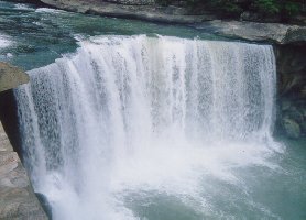
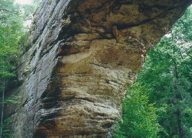
The outcrop of Pennsylvanian strata, shown on the geologic map, defines the limits of the Eastern and Western Kentucky Coal Fields (shown in gray on the physiographic map). The Eastern Kentucky Coal Field is part of a larger physiographic region called the Cumberland Plateau (which extends from Pennsylvania to Alabama. The western edge of the Eastern Kentucky Coal Field (and Cumberland Plateau) is called the Pottsville or Cumberland Escarpment. This escarpment (in large part) is formed from resistant Pennsylvanian-age sandstones and conglomerates. The escarpment is stepped in south-central Kentucky because several thick, resistant sandstones are separated by less resistant shales. The manner in which the sandstones weather and are eroded along the escarpment results in sheer cliffs, steep-walled gorges, rock shelters, waterfalls, natural bridges and arches, and some of the most scenic areas in Kentucky. Cumberland Falls State Park, Red River Gorge and Natural Bridge State Park are examples of some of these scenic areas along the escarpment.
 |
 |
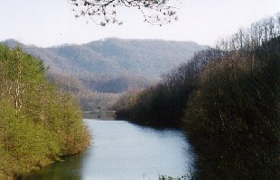
The interior of the Eastern Kentucky Coal Field is dominated by forested hills and highly dissected by V-shaped valleys. The scenery of Buckhorn and Jenny Wiley State Parks, and The Breaks Interstate Park is typical of the Eastern Kentucky Coal Field. In general, the elevations of the hills are highest in southeastern Kentucky where the highest elevation in the State, 4,145 feet (before mining), was at Black Mountain in Harlan County.
 |
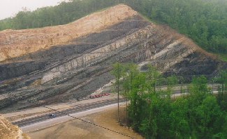 |
Pine Mountain is another important physiographic feature of the region. Pine Mountain is best described as a 125-mile long ridge that extends from southwest of Jellico, Tennessee to Elkhorn City, Kentucky. It is 3,200 feet high in Letcher County. Pine Mountain is the direct result of a fault, called the Pine Mountain Thrust Fault. Near the end of the Paleozoic era (around 230 million years ago), when the Appalachian Mountains were being built for the last time, a large block of the Earth's crust was pushed up and over the area that is now southeastern Kentucky. The pressures from mountain building caused the northeast edge of a block of Devonian, Mississippian, and Pennsylvanian strata to be pushed upward, forming a long mountain ridge. Because the fault pushed resistant Mississippian and Pennsylvanian-age sandstones upward, a resistant ridge formed, just like the Cumberland Escarpment.