
The Kentucky Geological Survey has archived this material, meaning (1) it is for reference, research, or recordkeeping; (2) it was created before April 24, 2026; (3) and the material has not been changed or altered since being archived. Please refer to our KGS Accessibility page for more information.
KGS Home > Geology of Kentucky
The Mississippian Plateau or Pennyroyal Region![]()
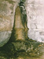
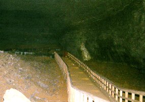
The Mississippian Plateau or Pennyroyal Region, shown in orange on the map, consists of a limestone plain characterized by tens of thousands of sink holes, sinking streams, streamless valleys, springs, and caverns. The term "karst" is used to define this type of terrain. The Karst terraine of the Mississippian Plateau occurs because the bedrock in the eastern and southern parts of the region is dominated by thick deposits of Mississippian-age limestones. These limestones are soluble (i.e. will dissolve) under the right conditions, which means they can easily be eroded by waters moving through the ground. These groundwaters can form miles of passages beneath the surface, from tiny paths only inches wide, to large caverns and rooms more than 100 feet wide. The Mammoth Cave-Flint Ridge cave system is the longest cave in the world (by far), and is formed in Mississippian-age limestones in the Mississippian Plateau Region. Carter Caves State Park, in Carter County, northeastern Kentucky, is another example of a cave formed in the soluble limestones of the Mississippian Plateau Region.
 |
 |
 |
The "Muldraugh Hills" is a ring of hills south of Louisville that occurs outward (southwest) from the Knobs Region. Rather than being isolated hills like the Knobs, the Muldraugh Hills are a ring of more continuous hills called an escarpment. This escarpment is comprised of easily eroded Mississippian-age shales that are capped by more resistant Mississipian-age limestones. A similar escarpment farther to the east, part of the Cumberland Escarpment, is found outward (south and east) from the Knobs (for example, the escarpments just south of Berea or near Morehead).
The Dripping Springs Escarpment occurs in the western part of the Mississippian Plateau Region. It is a line of hills formed by isolated Pennsylvanian- and Mississippian-age sandstones capping more erodable Mississippian-age shales and limestones. These hills have also been referred to as "knobs," and were formed from similar processes, but are not "The Knobs" of central Kentucky.
 |
 |
Another interesting feature of the western Mississippian Plateau Region is the geologic district known as the Fluorspar District (it is not a physiographic district). The Fluorspar District occurs in Caldwell, Crittenden, and Livingston Counties in western Kentucky. This region is characterized by complexly faulted strata. The faults were pathways for mineral-rich fluids, which deposited fluorine, zinc, lead, barium, cadmium, germanium, and silver minerals. During the early 1900's this region was the largest producer of fluorite in the United States. The fluorite was used in making the steel that fueled part of the Industrial Revolution.