
The Kentucky Geological Survey has archived this material, meaning (1) it is for reference, research, or recordkeeping; (2) it was created before April 24, 2026; (3) and the material has not been changed or altered since being archived. Please refer to our KGS Accessibility page for more information.
KGS Home > Geologic Hazards
Series of Earthquakes off the coast of Indonesia on July 17, 2006
A major earthquake occurred 225 km (140 miles) NE of Christmas Island or 355 km (220 miles) S of Jakarta, Java, Indonesia at 2:19 AM MDT, Jul 17, 2006 (3:19 PM local time in Indonesia) which generated a tsunami. For more information on this event, see this USGS site: https://earthquake.usgs.gov/eqcenter/recenteqsus/Quakes/uspaad.php
Numerous earthquakes have occurred in the same region on this day. At the time of this update, fourteen earthquakes had occurred off the coast of Indonesia with magnitudes ranging from magnitude 5.1 to magnitude 7.7.
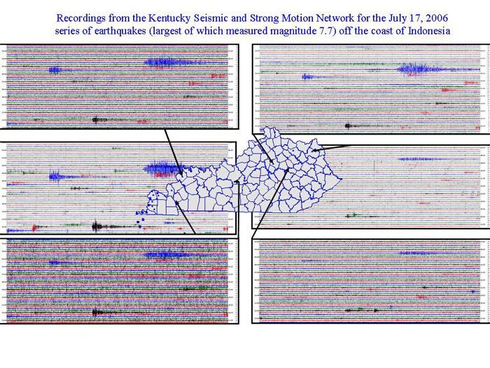
These earthquakes were recorded on instruments in the Kentucky Seismic and Strong Motion Network, operated jointly by the Kentucky Geological Survey and the Department of Earth and Environmental Sciences at the University of Kentucky.
The graphic below is the actual record of the earthquake made by 6 Network instruments.
Over 300 people killed, hundreds injured and many buildings destroyed by a tsunami with wave heights of at least two meters in the Pangandaran area. Felt as far as Jakarta. A tsunami with wave heights of 60 cm reported at Christmas Island.
The earthquake occurred as a result of thrust-faulting on the boundary between the Australia plate and the Sunda plate. On this part of their mutual boundary, the Australia plate moves north-northeast with respect to the Sunda plate at about 59 mm/year. The Australia plate thrusts beneath the Sunda plate at the Java trench, south of Java, and is subducted to progressively greater depths beneath Java and north of Java. The earthquake occurred on the shallow part of the plate boundary, about 50 km north of the Java trench. The region of the plate boundary between the Australia plate and Sunda plate is seismically highly active. From preliminary results, it appears that today's earthquake is similar to the earthquake of June 2, 1994, magnitude 7.8, which produced a tsunami that had a maximum run-up height of 13 meters and killed over 200 people. That earthquake occurred south of Java about 600 km east-southeast of today's earthquake, also as a result of thrust faulting on the shallow plate boundary. On August 20, 1977, a magnitude 8.3 normal-fault earthquake occurred within the Australia plate about 1200 km east-southeast of today's earthquake, producing a tsunami that had a maximum run-up height of 15 meters and killed almost 200 people. This year's May 26 devastating Yogyakarta earthquake, magnitude 6.3, occurred at shallow depth within the overriding Sunda plate.