
The Kentucky Geological Survey has archived this material, meaning (1) it is for reference, research, or recordkeeping; (2) it was created before April 24, 2026; (3) and the material has not been changed or altered since being archived. Please refer to our KGS Accessibility page for more information.
KGS Home > Geologic Hazards
Earthquake Hazard Information
Although we do not know when and where the next major earthquake will occur, we do know that an earthquake will cause damage, and the damage depends on many factors, such as earthquake magnitude, the distance from the epicenter, and local geology. Information on earthquake effects can be obtained by monitoring earthquakes and performing research. Such information is vital for earthquake hazard mitigation and risk reduction.
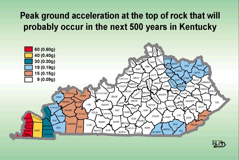
The most important information for seismic-hazard mitigation and risk reduction is ground-motion hazard. One way of predicting ground-motion hazard is by determining the peak ground acceleration (PGA) probably occurring in a particular timeframe. The map below shows the PGA at the top of bedrock that will probably occur in the next 500 years in Kentucky (Street and others, 1996). It shows, as expected, that PGA would be greatest in far western Kentucky near the New Madrid Seismic Zone. Ground-motion hazard maps for the central United States and other areas are available from the U.S. Geological Survey. These maps are used to set general policies on mitigating damage. For example, maps produced by the USGS in 1996 were used to determine seismic design in building codes.
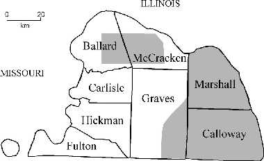 Seismic hazards associated with local geology, such as ground-motion amplification, liquefaction, and slope failure, also need to be considered in seismic-hazard mitigation and risk reduction. The map at left shows ground-motion amplification potential for the Jackson Purchase Region of western Kentucky (compiled by Street and others, 1997). The shaded areas represent classification C, very dense soil and soft rock, which means a low potential for ground-motion amplification. Mitigation measures in local communities can be fine-tuned by considering how the local geology relates to the hazard potential.
For information on the seismic network and seismic hazards, please contact the Department of Geological Sciences at 859.257.3758 or the Kentucky Geological Survey at 859.257.5500, both at the University of Kentucky. The Kentucky Division of Emergency Management and FEMA Web sites have information on earthquake preparedness.