KGS Home > Geologic Hazards
Seismic Hazard Assessment for Kentucky
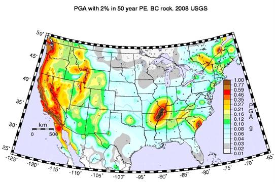
The Federal government uses seismic hazard maps produced by the U.S. Geological Survey for seismic safety design. The maps currently being used show the ground motion with 2 percent probability of being exceeded (PE) in 50 years, or once in about 2,500 years. The maps predict very high ground motion for western Kentucky, the Jackson Purchase Region in particular. They show peak ground acceleration of about 1.0g (or 1 times the acceleration due to gravity) near Paducah. The maps were used for seismic design in the 2000 International Building Code (IBC-2000) and the 2000 International Residential Code (IRC-2000). The design peak ground acceleration (PGA) is about 0.6g near Paducah according to IBC-2000 and IRC-2000. Currently, the highest PGA used in building design in California is about 0.4g (the 1997 Uniform Building Code [UBC-97]). Thus, the use of the USGS hazard maps has resulted in higher seismic design requirements in the Paducah area than anywhere in California, even though it is well documented that California has higher seismic risk. The high design ground motions have caused many problems in western Kentucky. For example, it would not be feasible for the U.S. Department of Energy to obtain a permit from Federal and State regulators to construct a landfill at a facility near Paducah if the USGS 2 percent PE in 50 years maps are used. The Structural Engineers Association of Kentucky also found that if IRC-2000 is adopted in Kentucky without a modification, constructing residential structures in westernmost Kentucky will be impossible without enlisting a design professional. The high design ground motion is also one of the reasons that Kentucky lost the chance to compete with Ohio for a new centrifuge facility ($2 billion).
Although it was a complicated process to develop the seismic design maps from the seismic hazard maps (see the Kentucky NEHRP Seismic Hazard and Design Maps Workshop Proceeding), a process that involve earth scientists, engineers, elected officials, and others, the higher design ground motions in Paducah than in San Francisco are not consistent with the basic geological and seismological sciences (Table 1). It does not make sense that the design ground motion in Paducah is about 30 to 50 percent higher than that in San Francisco from point of view of the geological and seismological sciences. Although “mitigating risks to society from earthquakes involves economic and policy issues” (Stein, 2004), seismic hazard assessment must be the basis. Our research shows that the key issues associated with the USGS national hazard maps are 1) the methodology (PSHA) being used, 2) some input parameters, and 3) confusion on the products (see Seismic Hazard Assessment: Issues and Alternatives; Comments on “Preliminary Documentation for the 2007 Update of the United States National Seismic Hazard Maps”).
Table 1. A comparison of design ground motion, geology, and seismology between San Francisco and Paducah.
|
San Francisco, California |
Paducah, Kentucky |
||
Design |
<=0.4g PGA |
<=0.7g PGA |
>0.4g PGA |
>1.0g PGA |
Geology |
San Andreas Fault |
New Madrid faults |
||
Seismology |
High earthquake activity |
Low earthquake activity |
||
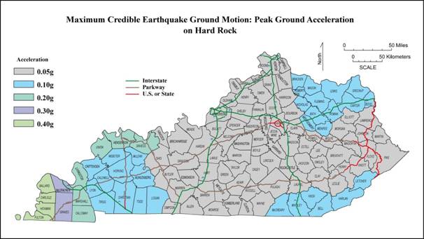
An alternative method, seismic hazard assessment (SHA), has been developed for seismic hazard assessment in the central United States (see a. UNDERSTANDING SEISMIC HAZARD AND RISK ASSESSMENTS: AN EXAMPLE IN THE NEW MADRID SEISMIC ZONE OF THE CENTRAL UNITED STATES; b. Seismic hazard and risk assessment in the intraplate environment:The New Madrid seismic zone of the central United States; and c. Final Report: Seismic Hazard Assessment of the Paducah Gaseous Diffusion Plant). SHA is comparable to the flood and wind hazard analyses in hydraulic and wind engineering. The hazard curves derived from SHA are comparable to those derived from flood-hazard analysis in hydraulic engineering and wind-hazard analysis in wind engineering, and have a similar meaning as well. Seismic risk estimated using SHA is comparable to the risk posed by other natural hazards such as hurricanes, winter storms, and volcanic eruptions. The deterministic or scenario based seismic hazard analysis can also be used for seismic hazard assessment. The following figure shows PGA from the maximum credible earthquakes in Kentucky (see Ground Motion for the Maximum Credible Earthquake in Kentucky).