The Kentucky Geological Survey has archived this material, meaning (1) it is for reference, research, or recordkeeping; (2) it was created before April 24, 2026; (3) and the material has not been changed or altered since being archived. Please refer to our KGS Accessibility page for more information.
KGS Home > Geologic Hazards
Seismic Hazard Maps and Time Histories for the Seismic Design of Highway Bridges in Kentucky
Engineering seismic designs and standards in the United States, as well as in the world, are based on experience from coastal California. The ground motion specified for bridge design in California is the deterministic ground motion from the maximum credible earthquakes. The ground motion from the maximum considered earthquakes was also recommended for building seismic design in California. In California, deterministic seismic hazard analysis (DSHA), not probabilistic seismic hazard analysis (PSHA), is being used to develop the design ground motion. The purpose of this project is to develop ground motions, including peak values and time histories, for seismic analysis and design of highway bridges in Kentucky. Therefore, we are using DSHA for this project.
Ground-motion hazards associated with three earthquake scenarios – the expected earthquake, probable earthquake, and maximum considered earthquake – were developed. The expected earthquake is defined in this study as the earthquake that could be expected to occur anytime in the bridge lifetime of 75 years. It is equivalent to the small earthquake defined in the existing The American Association of State Highway and Transportation Officials (AASHTO) provisions and similar to the expected earthquake defined in the Recommended LRFD Guidelines for the Seismic Design of Highway Bridges. The probable earthquake is defined as the earthquake that could be expected to occur in the next 250 years. Itis equivalent to the moderate earthquake defined in the existing AASHTO provisions. The maximum considered earthquake is defined as the maximum event considered likely in a reasonable amount of time. The phrase "reasonable amount of time" is defined by historical or geological records. For instance, the reasonable amount of time for the maximum considered earthquake in the New Madrid Seismic Zone is about 500 years, based on paleoliquefaction records. The reasonable amount of time for the maximum considered earthquake in the Wabash Valley Seismic Zone is about 10,000 years. The maximum considered earthquake is equivalent to the large earthquake defined in the existing AASHTO provisions and similar to the rare earthquake defined in the Recommended LRFD Guidelines for the Seismic Design of Highway Bridges.
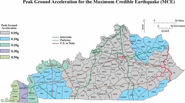
Three sets of hazard maps, depicting peak (horizontal) ground acceleration, short period (0.2 s) response acceleration with 5 percent damping, and long period (1.0 s) response acceleration with 5 percent damping were developed for three earthquake scenarios, the expected earthquake, probable earthquake, and maximum considered earthquake. The hazard maps predict the median ground motion and response spectra at the county seats from all earthquakes defined in each scenario. These maps are equivalent to the maps of horizontal peak-particle acceleration at the top of rock with a 90 percent probability of not being exceeded in 50, 250, and 500 years, defined in KTC-96-4 (Street and others, 1996)1). The recommended time histories were developed using the composite source model from the individual earthquake that has maximum ground motion and response spectra at the county seats in each earthquake scenario. The composite source model takes into account the source effects, including directivity and asperity, as well as three-dimensional wave propagation, and provides three-component ground motions that are physically consistent.
There are uncertainties inherent in these hazard maps and recommended time histories because of uncertainties in parameters that were used to derive the maps and time histories. Two groups of seismologists and engineers could provide two dramatically different estimates of seismic hazards for the central United States. Our maps and time histories are mostly based on the historical observations and instrumental recordings (see SEISMIC-HAZARD MAPS AND TIME HISTORIES FOR THE COMMONWEALTH OF KENTUCKY)
1) Street, R., Z. Wang, I Harik, and D. Allen, 1996, Source Zones, Recurrence Rates, and Time Histories for Earthquakes Affecting Kentucky, Research Report KCT-96-4, Kentucky Transportation Center, University of Kentucky, Lexington, Kentucky.