top of Tyrone and Knox (after L. B. Freeman.)
CAMBRIAN AND PRE-CAMBRIAN.—The oldest strata penetrated by the drill are those in the bottom of the 3200-foot William Hoover No. 1 well one-fourth mile south of Nicholasville in Jessamine County. The well is reported by Miller (1921) to have penetrated 2880 feet to the base of the Knox dolomite and to have finished in 320 feet of sandstone and shale referred to the Cambrian Nolichucky formation on the basis of the identification of trilobite fragments by Ulrich. It is located near the crest of the Jessamine dome and was begun in the Hermitage formation. No wells have penetrated to the Pre-Cambrian, and the above mentioned one is the only well reaching the Cambrian. A number of deep tests in Ohio, Indiana, and Illinois have reached the Pre-Cambrian, several of them penetrating igneous rock (Wasson, 1932; Condit, 1913; Logan, 1925, 1926). These include: (a) the Findlay, Ohio, wells, which penetrated a red granite gneiss at about 2800 feet, (b) the Ohio Oil Company's Burns No. 1 at Sandusky, Ohio, (c) the Greentown well, Howard County, Indiana, which encountered 20 feet of diabase (probably a dike) at 3885 feet, and (d) the Amboy well, Lee County, Illinois, which encountered a red granite gneiss at 3750 feet. The Friend well, 11 miles southeast of Springfield, Ohio, did not reach igneous rock but penetrated 2792 feet of rock below the Trenton and Black River. This included 421 feet of dolomite and a little arkose referred to the Cambrian or Upper Keweenawan and 807 feet of black carbonaceous limestone regarded as probably Pre-Cambrian (Wasson, 1932). The more recent H. E. Vance No. 1 well, ten miles south of Delaware, Ohio, completed in 1937, penetrated a 715-foot section of Cambrian at 3130 to 3845 feet and 446 feet of Pre-Cambrian gneiss to a total depth of 4291 feet (Stout and Lamey, 1940).
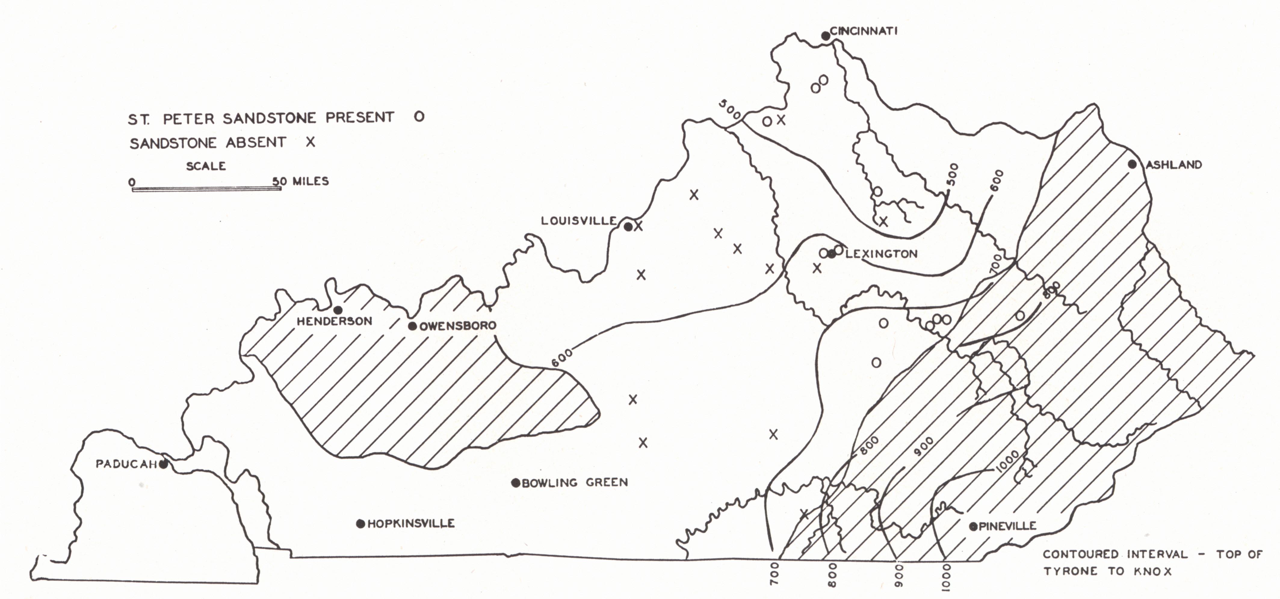
UNEXPOSED ORDOVICIAN.—The oldest rocks outcropping in the state belong to the High Bridge and include the Tyrone and Oregon (Lowville) and about 300 feet of the Camp Nelson (Stones River) exposed above drainage. The Blount has been regarded as unrepresented. Older formations have been penetrated in many places, but only in a few instances were samples saved. Knowledge of the deeper Ordovician in Kentucky is based on the earlier work of Meacham (1933) and the more extensive work of Freeman (1939), made possible by recent more active drilling to the horizon of the St. Peter and below.
Intervening between the bentonite layer (Pencil Cave) of the upper Tyrone and the St. Peter sandstone (when present) are 500 to 600 feet of limestone in central Kentucky. This sandstone is the first in descending the section, though everything called St. Peter (or Calciferous) has not been properly so-called. This leaves 200 to 300 feet of limestone between the lowest exposed Camp Nelson and the St. Peter. Meacham (1933) recognized an unconformity in the pre-Trenton of considerable magnitude. Such an unconformity was regarded as significant in its bearing on sub-surface structure. This has, however, been disproved by Freeman. Work of the same author shows the Stones River-Lowville succession to be rather uniformly thickening to the south and southeast from 500 to 600 feet in central Kentucky to 1000 feet in Knox County. Where a sandstone is absent, the horizon is represented by limestone with scattered grains of the typical sand. The consistent presence of a green bentonitic shale with the sandstone or, in the absence of the sandstone, just above the Knox (Cotter) dolomite, indicates a conformable relationship—the absence of the sandstone, a matter of changing lithology rather than unconformity. Such a green shale occurs at the top of the St. Peter sandstone in outcrop in Missouri.
The St. Peter, as a sandstone, is present in none of the wells so far drilled on the western side of the Arch, nor is it present apparently in Wayne and Clinton counties on the east (fig. 2). The occurrence of the sand on top of the Arch is rather spotted.
|
|
|
FIG. 2. Wells to the St. Peter Sandstone and isopach map on interval between
top of Tyrone and Knox (after L. B. Freeman.) |
The sandstone is a pure white quartz sand often with calcareous cement. The grains range from 0.1 to 0.8 millimeter, are well rounded, and have well developed frosted surfaces. This is regarded as evidence of eolian origin, though the wide extent of the formation would suggest final marine conditions of deposition. Unusual thicknesses of 40 feet on the Walnut Hall Farm near Lexington and of 63 feet on White Oak Creek northeast of Irvine in Estill County are known. This sand is a rather consistent producer of salt-sulphur (Blue Lick) water under artesian pressure. Flowing wells have been drilled in the Kentucky River Valley near Frankfort.
On the Walnut Hall Farm in Fayette County a second sand was encountered in the dolomite 100 feet below the St. Peter. In the Bond well at Lawrenceburg (Anderson County) the St. Peter was represented by a sandy limestone at 795 feet. At 1250 feet, about 450 feet in the Cotter, a lower sand of the St. Peter type was encountered bearing relatively fresh water and another, 100 feet below that. These lower sands seem to be represented in some of the older deep wells where they were consistently confused with the St. Peter. Born (1939) found that sandy horizons encountered 600 to 950 feet below the Pencil Cave in central Tennessee and commonly in the past referred to as St. Peter are sporadically developed sandy horizons of the Knox dolomite. They are usually less than 10 feet thick, and the sand seldom constitutes more than 5 per cent of the rock, though occasionally ranging up to 25 per cent. The St. Peter itself is not present.
While the upper sand from 600 to 1000 feet below the top of the Tyrone (Lowville) is commonly accepted as the St. Peter, this correlation has been questioned by Edson (1935). She called attention to the indeterminate position of the St. Peter in its type area because of the absence of Stones River beds. It is her opinion that the St. Peter will ultimately be shown to be above, instead of below, the Stones River. This would place it in the local section at the base of the Oregon,1 where an unconformity represented by the Blount group of Tennessee has commonly been recognized. There is, though, no physical indication of such a break, and the unconformable relationship is open to question. It is her opinion that the St. Peter does not extend this far east as a sandstone, and that the recognized sandstone or sandstones of drill records are more likely the eastern continuations of such beds in the Beekmantown of Arkansas, Missouri, Minnesota, Iowa, Wisconsin, and Illinois. With this opinion Ballard (1938) concurred.
Footnotes
1Note revised correlation of the Camp Nelson, Oregon, and Tyrone, page 12.