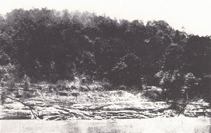
bank of the Kentucky River near Heidelberg, 4 miles southwest of Beattyville,
Lee County. A coal seam overlies the crossbedded sandstone (photo by Jillson,
1928f, p. 198).
Pennsylvanian rocks outcrop in two areas comprising the Eastern and Western coal fields. The Eastern field is traversed by a narrow belt of Devonian and Mississippian along Pine Mountain, where these systems, along with the basal Pennsylvanian, are brought back to the surface in the Pine Mountain overthrust. The rock is mainly sandstone and shale. The former is often massive and cliff-forming and a number of members are conglomeritic. The pebbles are typically vein quartz and the source was necessarily from out of the state. Local cherts are almost unrepresented. The rock is with few exceptions nonmarine, originating as the delta and floodplain deposits of a low swampy coastal plain. Marine invasions are indicated by the occasional limestone and fossiliferous shale zones. Under the circumstances there is rapid lateral variation in lithology. This is particularly true in eastern Kentucky.
Contact with the Mississippian is one of marked unconformity and this pre-Pennsylvanian erosion surface involves several hundred feet of relief. Among localities where this is well shown is the filled channel in Edmonson County in which the Kyrock asphalt deposits occur (J. M. Weller, 1927), and the buried channel of the Buford oil pool in Daviess County (Shiarella, 1933). This latter is also known in outcrop in the Rough Creek uplift. A third, which has been mistaken for "oil structure," is about a dozen miles northwest of Bowling Green and north of the mouth of the Gasper River. Here it is a pre-Pennsylvanian hill that is conspicuous. Extending across Edmonson, northern Hart, and southern Larue counties is a tongue of Pottsville resting on the St. Louis and projecting out into the Pennyroyal. This has been interpreted by Burroughs (1923) as a Pottsville-filled channel, which to the author seems to be the situation. Russell (1932, 1934) regarded this Pottsville-St. Louis relationship as due to up warp and truncation of the Mississippian. Jillson (1928b) has called attention to pre-Pennsylvanian deformation in western Hart County. The pre-Pennsylvanian channel shown in the bank of the Kentucky River at Heidelberg in Lee County is well known. Along the western edge of the Eastern Coal Field the beds underlying and in contact with the Pottsville range from the Pennington in the south to the Waverly in Lewis and Greenup counties.
|
|
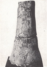
| FIG. 7. Pottsville channel fill in the Glen
Dean (Chester) limestone exposed in the bank of the Kentucky River near Heidelberg, 4 miles southwest of Beattyville, Lee County. A coal seam overlies the crossbedded sandstone (photo by Jillson, 1928f, p. 198). |
Of the four customary divisions of the Pennsylvanian, the Pottsville, Allegheny, and Conemaugh are found in both the Eastern and Western fields. The Monongahela is unknown in outcrop in eastern Kentucky. Glenn has recognized its possible presence in the western part of the state.
EASTERN COAL FIELD
The bulk of eastern Kentucky coal is from the Pottsville and the greater part of this from seams below the horizon of the Fire Clay coal. Outstanding producers below the Fire Clay coal horizon include the Jellico-Straight Creek (Cincinnati Southern, Jellico, and Southern Appalachian fields), Harlan (Harlan-Benham field), the lower Elkhorn-Pond Creek, etc., (Kenova-Thacker, and Elkhorn fields), the Elkhorn, including Elkhorn Nos. 1,2, and 3 (Elkhorn and Paintsville fields), and the Kellioka and "D" seam (Harlan-Benham field). The more important seams above and including that horizon are the Thacker (Kenova-Thacker field), the No.4 or Fire Clay coal (Elkhorn, Hazard, and Harlan-Benham fields) the Nos. 6 and 7 (Hazard field), and the High Splint (Harlan-Benham field).
A noteworthy feature of the stratigraphic section is the tremendous increase in thickness in the Pottsville, and to a lesser extent in the Allegheny also, toward the south and southeast. A section of about 400 feet of Pottsville in the Boyd County region increases to more than ten times that amount in Harlan and Bell counties of southeastern Kentucky. The increase is not a matter of basal overlap and is found in the section both above and below the Fire Clay coal. It is a matter of progressive subsidence. In this movement there came into existence much of the structure of the eastern flank of the Cincinnati arch shown in pre-Pennsylvanian rocks. When taken in consideration with similar progressive down warping in the Western basin, much, at least, of the Cincinnati arch came into existence without noteworthy central uplift (see p. 137).
| PLATE XIX | |
 |
 |
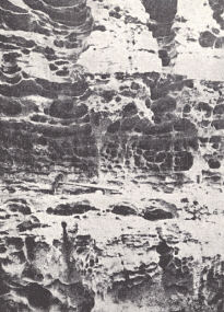
| FIG. 1. Honeycombed surface of
the Rockcastle conglomerate at Natural Bridge, Powell County. This is a characteristic feature of the weathered sandstone cliffs, a matter of the irregular cementation of the sandstone. |
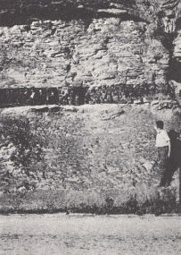
FIG. 2. Small coal seam near
Corbin, Kentucky. |
 |
 |
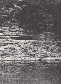
| FIG. 3. Crossbedded
Pennsylvanian sandstone, Elkhorn City. |
FIG. 4. Fossil tree stump--Sigillaria--from
the Fordson mine, Harlan County. It is a mass of sandstone surrounded by a thin shell of carbonized wood (coal) and represents a hollow stump in which the interior had rotted leaving only a rim of bark in .and around which the sand was deposited. Height 3 feet plus. |
POTTSVILLE
Lee conglomerate (Campbell, 1893, from Lee County, Virginia).—The
formation as originally described is composed of three beds of massive sandstone
or conglomerate separated by intervals of shale and thin sandstones, the whole
carrying from two to six seams of coal. A maximum thickness of 1530 feet is
attained at Big Stone Gap, which decreases to the northwest to 1200 feet and
less. The top of the formation is marked by a massive cross-bedded conglomeritic
sandstone member known as the Bee Rock, about 100 feet thick and cliff-forming.
The name was first used by Stevenson1 (1881) and was again used by
Campbell in the region of the Estillville and Wartburg quadrangles, Tennessee.
The middle conglomeritic sandstone of Campbell was termed the Bald Rock
conglomerate by Eby (1923) in his report on Wise County, Virginia. It is 200
feet thick at Big Stone Gap and 100 feet at Little Stone Gap, Virginia. No name
was given to the basal sandstone which is the most coarsely conglomeritic of the
three with pebbles up to an inch in diameter. It ranges up to 250 feet thick.
As used by the same author in the region of the London and Richmond quadrangles in Kentucky, the Lee consists of a similar succession 200 to 600 feet thick in the former area and 100 to 300 feet in the latter. Two conglomeritic members, the Rockcastle and the Corbin, are recognized. The latter is accepted as marking the top of the formation. As used in the Richmond and London quadrangles, it does not seem to be coterminous with the Lee of Lee County, Virginia, but includes the latter and the lower Norton.
Rockcastle conglomerate (Campbell, 1898).—This is a massive lenticular sandstone and conglomerate up to 200 feet thick. In places it occupies a channel eroded through the Pennington shale and at least 100 feet into the underlying limestone. Elsewhere it is underlain by shales (Pennsylvanian) to which Miller (1919) applied the term Beattyville shale. It is a cliff-forming formation and caps the Pottsville Escarpment through much of its extent, and Cumberland Falls. The name is taken from the Rockcastle River where these cliffs are conspicuously developed. Campbell correlated this conglomerate with the lower conglomerate of the Lee in northern Tennessee, where it is underlain by not more than 250 feet of coal-bearing shale and sandstone. To the north along the Pottsville Escarpment in Kentucky it is less consistently developed. It is tentatively correlated with the Sharon conglomerate of Ohio and the Kenova quadrangle in Kentucky, with the Kyrock conglomerate of western Kentucky, and the Raleigh sandstone of West Virginia (Wanless, 1939).
Miller (1910) suggested the name Livingston conglomerate for a similar but lower conglomerate north of Livingston in Rockcastle County, where it fills a channel cut deep into the Mississippian. This was earlier studied by Campbell (1898a) who was uncertain as to its relationship to the Rockcastle. Wanless (1939) confirmed the work of Miller in designating it as a separate and lower lentil. It underlies the Hudson coal while the Rockcastle lentil occurs higher in the section. The rock is a very pebbly sandstone poorly cemented, and breaks down readily on weathering. It has been the source of gravel for concrete work and the abundant pebbles of quartz have given rise to the name Roundstone for the creek and railroad station in that vicinity.
Corbin conglomerate (Campbell, 1898, from Corbin, Whitley County).— This is a second conglomeritic sandstone several hundred feet above the Rockcastle, 100 to 200 feet thick in the London quadrangle and similarly a lentil. It is not so well indurated and hence not so conspicuously cliff-forming. It is more commonly a sandstone than conglomerate, is mealy (friable) in character, and the rock weathers into rounded masses with a pinkish color.
Sharon conglomerate.—The name was first used in Kentucky by Phalen (1912), who provisionally correlated this conglomerate in the Kenova quadrangle with the Sharon of Ohio and Pennsylvania. It seems to be the northern extension of the Rockcastle, is similar in character, and similarly lenticular, ranging in thickness up to 100 feet. Inequalities in thickness express the inequalities in the pre-Pennsylvanian surface on which it was deposited. Over much of Greenup and Carter counties it is not present and the higher Sciotoville fire clay forms the base of the section.
These conglomerates are well expressed topographically. The Rockcastle caps the eastern Pottsville Escarpment and the eastward sloping stripped plain to the east. The northward dying out of the Escarpment is due to the lesser development of the conglomeritic sandstone, aided also by the northward pinching of the underlying limestones. The Corbin with its lesser induration is not the equal of the Rockcastle, but is more resistant to erosion than the overlying Breathitt shales. Stripping of the overlying shales has produced extensive flats as those around Whitley City and Cumberland Falls.
Sciotoville (Ohio) = Olive Hill (Kentucky) fire clay.—A thick high grade refractory clay worked around Sciotoville, Ohio, and in the Olive Hill district of Carter, Greenup, and Rowan counties, Kentucky. It overlies the Sharon conglomerate but forms the base of the Pennsylvanian section where the Sharon is missing in much of Greenup and Carter counties.
Other locally conspicuous (topographically as well as stratigraphically) sandstones of the Pottsville include:
High Rock sandstone (Browning and Russell, 1919).—A massive soft coarse-grained white to brownish white sandstone of Magoffin County and vicinity. It is commonly cliff-forming but not consistently so. Thickness, 30 to 50 feet in Magoffin County. It occurs in the Breathitt formation and occupies the interval between the Flag Coal Rider and Fugate coal.
Puncheon Creek sandstone (Browning and Russell, 1919).—A massive coarse-grained sandstone in Magoffin County of essentially the same character as the High Rock occupying the interval between the Fugate and Hindman coals. It is 70 to 120 feet thick, of which the upper ±60 feet are cliff forming. The lower part is finer grained, more shaly, and less commonly cliff forming.
Peach Orchard sandstone (Hudnall, 1926).—A cliff-forming sandstone underlying the Peach Orchard coal of Lawrence County. The same author (1927) designated this sandstone as the Lower Peach Orchard in Martin County. It has a thickness of about 100 feet. In the same report the name Upper Peach Orchard was used for a similar sandstone above this coal and separated from the Broas coal above by a few feet of shale. They are the equivalents of the Lower and Upper Coalburg sandstones of West Virginia (Wanless, 1939).
Homewood sandstone.—Phalen (1912) recognized this massive sandstone in the Kenova quadrangle as the Homewood sandstone of Pennsylvania which marks the top of the Pottsville. It varies within the Kenova quadrangle from 25 to 100 feet in thickness and overlies the Upper Mercer (Fire Clay) coal. Hudnall (1927a) recognized it in Martin County as a massive coarse cliff-forming sandstone 100 feet thick, 350 to 400 feet above the Fire Clay coal and about 30 feet below the Richardson coal. He called attention to the earlier mistaken identification in West Virginia of the sandstone overlying the Fire Clay coal as the Homewood.
Breathitt formation (Campbell, 1898).—A succession of shales and sand-stones overlying the Corbin conglomerate in the London quadrangle. The highest hills of the region give it a thickness of at least 550 feet.
In the region of the Cumberland Gap coal field of Belle and Harlan counties Ashley and Glenn (1906) have subdivided the exposed Pottsville into the Lee, Hance, Mingo, Catron, and Hignite as mappable formations. The coal seams and conspicuous sandstones used as formation boundaries are shown in plate XX.
Lee.—The formation has a thickness of 1200 to 1500 feet. It is massive, cliff forming, and commonly conglomeritic, particularly in the lower part. Some of the sandstones are quartzitic. To the cliff-forming member at the top of the formation Ashley and Glenn (1906) gave the name Naese sandstone so-called from exposures on the Cumberland River known as Naese cliff 8 miles by road north of Pineville. The thickness is in excess of 100 feet. It is heavy bedded and strongly cross bedded. The weathered, pitted surface has as elsewhere given rise to the local term "Bee Rock."
Hance (from Hance Creek southeast of Pineville, Bell County).—This is mainly a shale formation about 600 feet thick, limited by the Naese sandstone below and the Lower Hance (= Harlan = Puckett Creek) coal above. Two prominent cliff-forming sandstone members are present, the Yellow Creek sandstone and Cawood sandstone. The former occurs mainly below drainage and the latter, with a thickness of about 80 feet, is a cliff former over wide areas. Other sandstones are locally massive. It is not an important coal-bearing formation.
The Harlan coal is correlated with the Standiford of Virginia. On this basis the Hance is the equivalent of the Norton formation, Gladeville sandstone, and lower one-third of the Wise formation of Wise County, Virginia.
Mingo (from Mingo Mountain, Claiborne County, Tennessee).—The limits of the Mingo are defined as the base of the Wallins Creek = Poplar Lick (Fire Clay) coal above and base of the Harlan coal below. It is an important coal producing formation and includes the Mingo (= Creech), Sandstone Parting, and Lower Hance (Harlan) coals. The thickness varies from 950 feet in the south to 700 feet in the north. It is an alternation of sandstones and shales with cliff-forming sandstones at five horizons. Two of them have been recognized and named in the Black Mountain region (Slaters and Puckett sandstones). A third is recognized at a lower level in the Log Mountain region—the Fork Ridge sandstone.
As correlated above this formation would correspond to about the middle third of the Wise formation of Virginia.
Catron (Catron Creek, Harlan County).—The formation is defined as including beds between the base of the Poplar Lick (Fire Clay) and base of the Hignite coals in Log Mountain, and from the base of the Wallins Creek coal ( = Poplar Lick) to the top of the Jesse sandstone in Black Mountain. This sandstone seems to be the equivalent of a cliff-forming sandstone a few feet below the Hignite coal in the Log Mountain region. The formation is largely shale and thin sandstones with a thickness of 300 to 320 feet. Besides the important Wallins Creek = Poplar Lick coal at the base, the Smith "11-foot" coal occurs on Black Mountain and the Klondike coal in Log Mountain. In addition to the Jesse sandstone in the Black Mountain section, a second unnamed sandstone occurs lower. In Log Mountain there is a similar sandstone at about this same horizon. The Jesse sandstone is described as 20 to 70 feet thick, coarse grained and gritty, especially in its lower part where small pebbles up to one-eighth and one-fourth inch in diameter occur. In its typical development it is not cliff forming.
Hignite (Hignite Creek, Bell County).—The Hignite includes beds be¬tween the base of the Lower Hignite coal and the top of the Red Spring coal, with a thickness of 440 to 540 feet. The Red Spring sandstone underlying the Red Spring coal is a cliff-forming sandstone over a considerable area. The only commercial coals are the two Hignite beds at the base. In Black Mountain the formation is regarded as including everything above the Jesse sandstone, though the Bryson may be represented at the top. The Reynolds sandstone is a cliff-forming member 50 to 100 feet thick. It is well exposed in Hanging Rock of Reynolds Mountain and Pilot Rock of Little Black Mountain. There are other locally cliff-forming but less conspicuous sandstones.
Bryson (from Bryson Peak in Log Mountain, Claiborne County, Tennessee). About 200 feet of the formation is present in the highest peaks of Log Mountain. It includes three seams above the Red Spring coal. One or two coals of workable thicknesses are present but the area underlain is small.
In his report on Wise County, Virginia, Eby (1923) recognized the Lee and Norton formations, Gladeville sandstone. Wise formation and Harlan sandstone. These formational units are given here because of their applicability to the section in adjoining parts of Kentucky (Letcher and Pike counties). The Lee has been discussed on a previous page.
Norton formation (Campbell, 1894).—A coal-bearing succession 1300 to 1500 feet thick composed of shales, coals, and sandstones. The name comes from Norton, Virginia, and is based on a mistaken identification of beds outcropping there. It is bounded above by the base of the Gladeville sandstone. Shale is predominant and limestone or calcareous shale was not observed. A prominent sandstone member near the middle of the formation has been named the McClure sandstone. This is massive, coarse grained, and cliff-forming, similar to the Gladeville. Thickness, 57 to 200 feet.
Gladeville sandstone (Eby, 1923).—The name is taken from Gladeville (now known as Wise), Wise County, Virginia, and is important as the only conspicuous and widespread sandstone between the "Bee Rock" of the Lee and the Harlan sandstone. The rock is a massive, cliff-forming, rather pure quartz sandstone about 100 feet thick. To the north it contains more feldspar and mica and is iron stained. At least locally it is water-bearing. It is correlated with the Grapevine sandstone of West Virginia (Wanless, 1939).
Wise formation (Eby, 1923).—A more or less monotonous repetition of sandstones and shales with little lithologic individuality. Coal is more abundant than in the Norton and one or more thin limestones occur. The formation has a thickness of 2300 feet in the western part of Wise County, Virginia, and thins slightly to the northeast. It is defined as including those rocks lying between the Gladeville and Harlan sandstones. The following units are recognized as valuable horizon markers:
(a) Addington sandstone member.—A thick coarse sandstone suggestive of the Gladeville about 150 feet above the base of the formation.
(b) A coarse micaceous sandstone below the Imboden coal.
(c) A hard fine-grained sandstone lying between the Taggart coal and Taggert
Marker and about 1000 feet above the base of the formation.
(d) A local zone of marine fossils about 60 feet below the Imboden coal.
(e) A fossiliferous limestone up to 3 feet thick on the west side of Black
Mountain 50 to 100 feet above the Pardee coal (= Haddix). This would be the "
Fossil limestone" of Kentucky.
Harlan sandstone (Eby, 1923—from Harlan County, Kentucky where it outcrops near the crest of Black Mountain).—It is a massive cliff-forming formation 120 to 130 feet thick. The lower 20 to 30 feet are arkosic and weather to thin layers. These are overlain by massive conglomeritic sandstone. In some places in Black Mountain 750 feet of sandstone and shale overlie the Harlan sandstone.
FOSSILIFEROUS ZONES OF THE POTTSVILLE
Campbells Creek limestone.—A limestone 30 to 40 feet above the coal of the same name in Kanawha County, West Virginia. Robinson (1926a) recognized a sparingly fossiliferous concretionary limestone at about this horizon and below the Van Lear coal in Morgan County.
Dwale shale (Morse, 1931).—This fossiliferous zone is known only from specimens of Lingula carbonaria collected in the dump of the abandoned mine of the Dwale Coal Company and is named after that town in Floyd County. The shale forms the roof of the Prestonsburg = Van Lear coal.
Elkins Fork shale (Morse, 1931, from Elkins Fork School, Williamson quadrangle, northern Pike County, Kentucky).—The fauna, composed dominantly of species of "Productus," is found in 8½ feet of shale 50 feet below the Kendrick shale. Wanless (1939) regarded it as probably the equivalent of the Seth limestone of West Virginia.
Dingess limestone (Dingus of some writers, from Dingess tunnel, Mingo County, West Virginia).—This limestone overlying the Amburgy coal is generally absent in Greenup and Carter counties but is well developed near West Liberty and to the south. Here it forms two benches separated by shale, corresponding in this feature and lithology to the lower Mercer limestone of Ohio with which it is correlated (Wanless, 1939). Fossils are common in Pennsylvania and Ohio and include Mesolobus striatus and Marginifera haydenensis. A band of carbonate iron ore comes above the upper bench.
It is a fairly widespread marine zone in eastern Kentucky. South of the Paint Creek-Warfield anticline the lower bench becomes discontinuous and more sandy; the upper bench is similarly lenticular and the shale interval expands greatly. The upper limestone and the shale are locally fossiliferous (Morse, 1931 and Jillson, 1919g). In Floyd County Jillson (ibid.) proposed the name Kendrick shale from exposures of blue to carbonaceous shales at the Kendrick homestead on the headwaters of Cow Creek.
Fossil limestone.—This is the most persistent limestone in eastern Kentucky. The name was first used by Browning and Russell (1919) in Magoffin County, where it forms a thin bed of fossiliferous limestone in two layers separated by 1 to 15 feet of soft dark blue shale sometimes containing crinoid fragments. The upper layer is described as fine grained, 1 to 2½ feet thick, with many brachiopods; the lower is dark grey, medium to coarse grained, with brachiopods and some molluscs. It lies about 10 feet above the Haddix coal and is persistent over the county. The Lost Creek limestone (Morse, 1931,—from Lost Creek, Breathitt County, with type and only known locality in the northern part of the Buckhorn quadrangle, Breathitt County, has since been identified with the "Fossil limestone" (Wanless, 1939). It was described as a 3½-foot limestone, the upper one-third blue and shelly, the lower two-thirds dolomitic and fossiliferous. The interval by which it overlies the Fire Clay coal is considerably greater than in Magoffin County. The Fossil limestone is correlated (ibid.) with the Putnam Hill limestone of Ohio and Buffalo Creek limestone of West Virginia and seems to mark the maximum marine invasion of the Pennsylvanian to the southeast.
Magoffin beds (Morse, 1831,—from Magoffin County).—These are de-scribed as two thin beds of limestone, separated, overlain, and underlain by shale. According to Wanless (1939) the lithology in Ohio is essentially the same as in Magoffin County except for the presence of a lower dark grey to black flint zone. The limestone is described as somewhat siliceous and ferruginous, blue-grey to dark grey, in two benches, with an upper zone of blue-grey iron carbonate weathering to brownish yellow limonite on outcrop. It occupies the lower part of a shale zone in the top of which the Salt Lick marine zone occurs. The iron ore was at one time extensively mined in the southern Ohio district. It is known as far south as West Liberty, Morgan County, and roughly to the Paint Creek-Warfield anticline. The shale varies from fossiliferous to nonfossiliferous.
This calcareous horizon has been confused rather consistently with that of the "Fossil limestone" in Kentucky literature, until recently differentiated by Wanless. The Magoffin beds come below the Haddix coal while the Fossil limestone overlies it. These beds constitute a persistent horizon over the northern half of the Eastern Coal Field and correlate with the upper Mercer (Ohio) and Winefrede (West Virginia) limestones (Wanless, 1939).
Salt Lick beds (Morse, 1931).—A thin marine zone of fossiliferous large flattened silty or sandy limestone concretions up to 2 feet thick. It comes below the Haddix coal and 20 feet (Leslie County) to 60 feet (Pike County) above the Magoffin beds. With increase in interval the beds become more sandy. It is known only in the region between the Paint Creek-Warfield anticline and Pine Mountain fault. The fauna is much like that of the Magoffin beds.
Flint Ridge flint (Morse, 1931).—The type locality is at the head of Leatherwood Branch of South Quicksand Creek in the northwest rectangle of Troublesome quadrangle, Breathitt County. The bed outcrops at about the 1500-foot level 30 feet below the top of the ridge. It is a 10-foot bed of flint without fossils, overlying 15 feet of fossiliferous marine dolomitic limestone. Wanless (1939) has correlated it with the Zaleski flint of Ohio and the Kanawha black flint of West Virginia. It is so far known in eastern Kentucky only at the type locality. It lies 500 to 600 feet above the Magoffin beds and about 100 feet below the Hindman coal.
ALLEGHENY
The Allegheny includes those beds intervening between the top of the Homewood sandstone and the base of the Mahoning sandstone. In the absence of the former as a recognizable unit the overlying Hindman coal is commonly used; similarly the upper Freeport coal at the base of the Mahoning sandstone. It is not the thick widespread formation that the Pottsville is in eastern Kentucky. The main area of outcrop is in Boyd and adjoining counties and along the center of the Middlesboro syncline; elsewhere, only on the hilltops. In the Boyd County region the thickness usually is 150 to 200 feet, sometimes as low as 100 feet. To the south in Harlan County it approximates 500 feet.
The series is shale alternating with sandstone and occasionally limestone. It includes a number of commercial seams of coal, of which only one, the High Splint in the Harlan Field, is an outstanding commercial seam. Other producing seams, all relatively small, are the No. 7 in the Princess Field, No. 7 and High Splint in the Elkhorn Field, and No. 9 in the Hazard Field.
Named formations include:
East Lynn sandstone (Krebs and Teets, 1913).—The name has been used in Martin County, Kentucky, by Hudnall (1927a) for a sandstone above the Richardson = Lower Kittanning coal. It is a conglomeritic sandstone of well-rounded quartz pebbles from one-fourth to 2 inches in diameter with a thickness of 50 to 80 feet and caps the ridges forming the county line between Johnson, Lawrence, and Martin counties. At the type locality, East Lynn, Wayne County, West Virginia, it occupies a position between the Lower and Middle Kittanning coals.
Van Port limestone (White, 1878—the Ferriferous limestone of the Ohio Geological Survey and Hanging Rock limestone of Orton, 1878).—The name comes from Van Port on the Ohio River in Beaver County, Pennsylvania, where the limestone occurs between the Clarion and Lower Kittanning (above) coals. It was first identified in Kentucky by Phalen (1912) in the Kenova quadrangle. It is a 4- to 6-foot subcrystalline limestone with uneven upper and lower surfaces, with stratigraphic position about 20 feet above the Homewood sandstone, but at times resting on it, and a short distance below the Lower Kittanning coal. Above this limestone and occupying the interval between it and the Lower Kittanning coal in Ohio are the Lawrence commercial refractory and plastic clays. They are not prominent south of the Ohio River where the interval is occupied by the massive Kittanning sandstone. The top of the bed is marked by a bed of "limestone ore,” a fine-grained nodular blue-gray carbonate of iron (the Ferriferous Ore of the Hanging Rock district of Ohio and Kentucky), which occurs in weathered outcrop as limonite. It is a few inches to several feet thick and often pockety.
The Van Port limestone has been recognized as far south as Elliott County (Stevenson, 1906). It is regarded (Wanless, 1939) as probably the equivalent of the Seahorne limestone of western Illinois or the lime¬stone roof of the Mining City coal, Hancock County, Kentucky.
"Yellow kidney ore" and "red kidney ore" occur at several levels in the Allegheny.
CONEMAUGH
The Conemaugh series includes the beds between the Upper Freeport coal (base of Mahoning sandstone) and the base of the Pittsburgh coal. The area of outcrop is more or less restricted to the vicinity of Boyd and northern Lawrence counties. Thickness, 450 to 600 feet. The lower 100 feet of the formation is largely sandstone, including the massive Mahoning sandstone at the base and another higher massive member. The upper part, though with some heavy sandstones, is mainly shale in which purple, red, and green colors are conspicuous. It does not include commercial coals. Several limestones are present.
The following formations are recognized:
Mahoning sandstone (Lesley, 1856).—The type locality is in Pennsylvania, and the formation is known in that state, West Virginia, and northeastern Kentucky where it is a massive cliff-forming sandstone forming the base of the Conemaugh with a thickness of 70 to 100 feet. Some shale partings are present. To the west it loses its identity as it becomes more shaly and thinner bedded. In much of its extent an upper and lower Mahoning sandstone is recognized.
"Lower Cambridge limestone."—This unit as described and correlated by Phalen (1912) in the Kenova quadrangle is a persistent limestone 4 to 5 feet thick just above the Mahoning sandstone and Brush Creek coal. It is highly siliceous and resistant to weathering, though locally shaly and highly fossiliferous. The limestone is apparently the widespread Brush Creek limestone and is known southward in Lawrence County.
Buffalo sandstone (Phalen, 1912).—This is a 20- to 40-foot massive, coarse grained, usually cliff-forming sandstone about 35 feet above Phalen's "lower Cambridge limestone" (Brush Creek).
Ames limestone.—This name was used with some uncertainty by Phalen (1912) for 8 to 10 feet of limestone in about the middle of the series. Though regarded as possibly the Upper Cambridge, it was correlated with the Ames of West Virginia because of its crinoidal character. Other fossils were present but had not been studied.
A massive 35- to 40-foot sandstone overlying the limestone by an interval of up to 100 feet has been referred to the Morgantown sandstone of West Virginia on the basis of the correct identification with the Ames limestone.
MONONGAHELA
While known just across the state line in West Virginia near Lett (opposite southeastern Boyd County), the Monongahela has not been recognized in outcrop in eastern Kentucky.
WESTERN COAL FIELD
The Pottsville, Allegheny, and Conemaugh series are represented with possibly some Monongahela. Formations and formational boundaries commonly recognized are indicated in figure 8 following the classification as outlined by Glenn 1922.
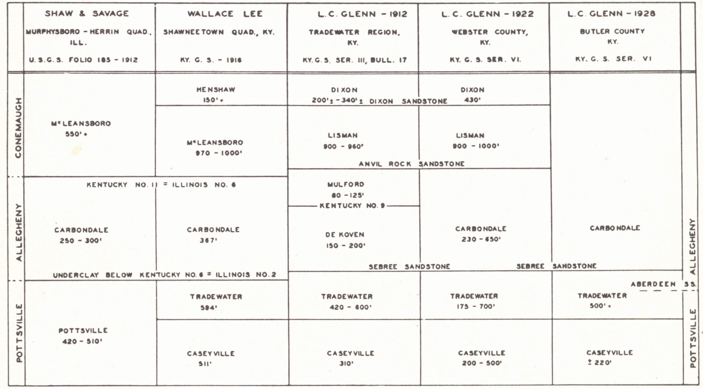 |
| FIG 8.—Classification |
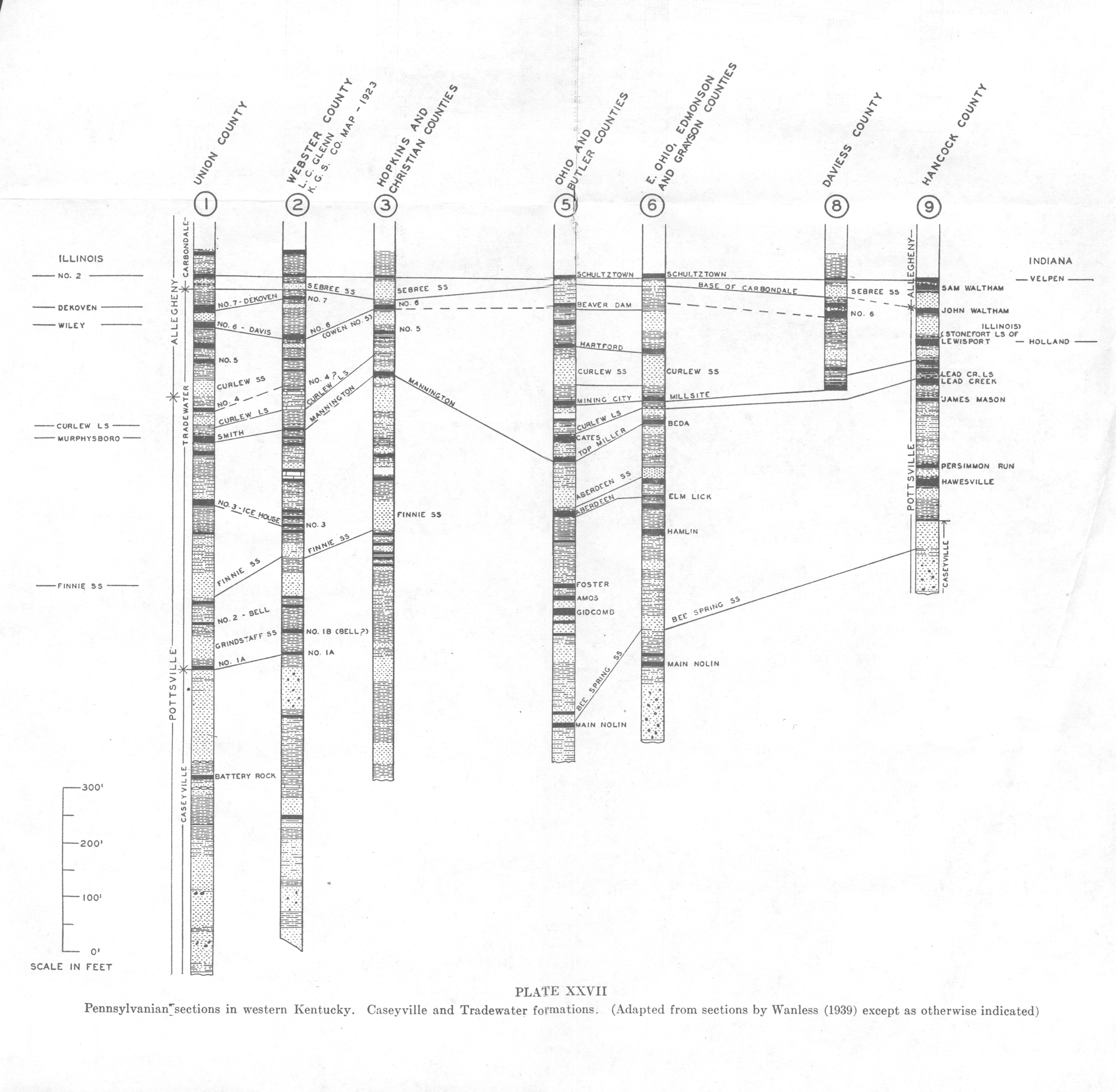
Caseyville (Owen, 1856).—The formation is typically a massive cliff-forming cross-bedded usually coarse grained and frequently conglomeritic sandstone similar in character to the Rockcastle. It is firmly to weakly cemented with silica or limonite, the latter often irregularly distributed, and on weathering left protruding, giving a honeycombed ("Bee Rock") surface. These limonitic bands seem to be controlled in part by bedding, including cross-bedding, and in part apparently concretionary in development. The pebbles are vein quartz, ½ inch and less in diameter. Lithology changes rapidly laterally. Associated with the sandstones are shale zones from a few feet to 50 feet or more thick. One such shale zone 50 to 100 feet thick in Edmonson County and vicinity in the middle of the formation separates off an upper Bee Spring sandstone member (Norwood 1876) which Wanless (1939) regards as probably the equivalent of the Corbin conglomerate of eastern Kentucky. It is a 40- to 60-foot sandstone, similar to the lower sandstone but less massive and with smaller pebbles.
The Caseyville is bounded above mainly on lithology, i.e., by the top of the massive conglomeritic sandstone, which approximates a position close beneath Owen's No. 1a coal. In Union County and vicinity the term Battery Rock has been used. The Kyrock conglomerate is a pebbly sandstone locally impregnated with asphalt at Kyrock and vicinity, Edmonson County. It is the lower conglomerate and a channel fill, which may be traced eastward into Hart, Green, Taylor, and Larue counties. The Caseyville is the Lick Creek sandstone of southern Illinois, the Mansfield of Indiana, and is regarded as the equivalent of the Rockcastle = Sharon conglomerate of eastern Kentucky.
The Caseyville outcrops in the rugged border belt of the Western Coal Field and reappears in the Rough Creek uplift. The thickness varies from 200 to 500 feet or more, with a maximum attained in the pre-Pennsylvanian valley fills. The lower sandstone in Edmonson County has a thickness of 250 feet in the channel. Farther north, it is generally absent or present only as local lenses (J. M. Weller, 1927). Oil and gas are produced from it in the Buford Pool and elsewhere.
Tradewater (Glenn, 1912—upper Pottsville (mainly), exposed along the Tradewater River, Union County).—This is dominantly a shale formation bounded below by the Caseyville and above by the base of the Sebree sandstone which occurs a short distance above No. 7 coal. It has a thickness of 400 to 700 feet. Sandstones are subordinate, are inclined to be fine grained and shaly, and are usually in the lower part. A number of conspicuous sandstones are recognized:
(a) The Grindstaff sandstone (Butts, 1925) of Gallatin County, Illinois, in the lower part of the Tradewater formation is recognized in Union County, Kentucky, just above No. la coal. It is fine grained, light grey, and finely indurated, and thus does not readily crumble. The sharp-edged fragments in stream beds do not readily round off.
(b) Finnie sandstone (Owen, 1856 and Glenn, 1912—in the lower Tradewater above the No. 2 = Bell coal).—The name is taken from Finnie bluff along the Ohio River near Caseyville, Union County, where the massive sandstone is exposed. As a distinct member, it is restricted to the western counties but is extensively developed and sometimes is conglomeritic in southern Illinois. It is highly ferruginous and in places weathers with a honeycombed surface. It attains a maximum thickness of 80 feet.
(c) The Aberdeen sandstone (Crider, 1915c—from Aberdeen near Morgantown, Butler County, Kentucky) is a well-defined massive and cliff-forming sandstone member 30 to 100 feet thick in Butler County. It is medium to coarse grained, friable and micaceous, similar in lithology to the higher Curlew sandstone. Locally it has been observed to occupy channels in the underlying rock up to 30 feet deep.
(d) The Curlew sandstone (Owen, 1856—from exposures in Union County) is massive, friable, strongly cross-bedded and cliff-forming, about 50 feet thick, with a well-marked unconformity at its base. Its recognition is facilitated by its position a little above the Curlew limestone. It is known through a considerable part of the Western Kentucky field and Southern Illinois.
(e) Curlew limestone (Owen, 1856).—This limestone at its type locality at Indian Hill in Union County consists of two beds of limestone each 2 feet thick separated by 15 feet of shale. The upper ledge is about 25 feet below the Curlew sandstone. The limestone is described as blue-grey and argillaceous, and carries species of Marginifera and Mesolobus. Locally it weathers to a porous chalky chert and in Ohio County has been referred to as the Fusulina chert. In Hancock County it was called the Lead Creek limestone (Crider, 1913a). It occurs there as 3 or 4 ledges of limestone, individually from a few inches to 10 feet thick, forming a zone of 30 or 40 feet. The lower ledge often forms the roof of the Lead Creek coal. A prominent band of flint occurs in a crinoidal limestone 7 feet above the base. A middle ledge weathers yellow and is honeycombed. An upper 2-foot ledge is dark blue limestone with large crinoid stems.
The Curlew is correlated with the Minshall of Indiana and Seville limestone of western Illinois. It has been known as the Mannington limestone in the vicinity of the city of that name in northern Christian County. Here it occurs about 35 feet above the Mannington coal and has been useful in correlating the Mannington, Dawson Springs, and Empire coals.
(g) The Stonefort limestone of Illinois just above the horizon of the Curlew sandstone has been recognized recently (Wanless, 1939) in Union, Ohio Daviess, and Butler counties and correlated with the argillaceous limestone above the Lewisport coal in Hancock County.
The Tradewater is subordinate as a commercial coal producer. Com¬mercial seams include the Empire, Mannington, and No. 2 = Bell coal.
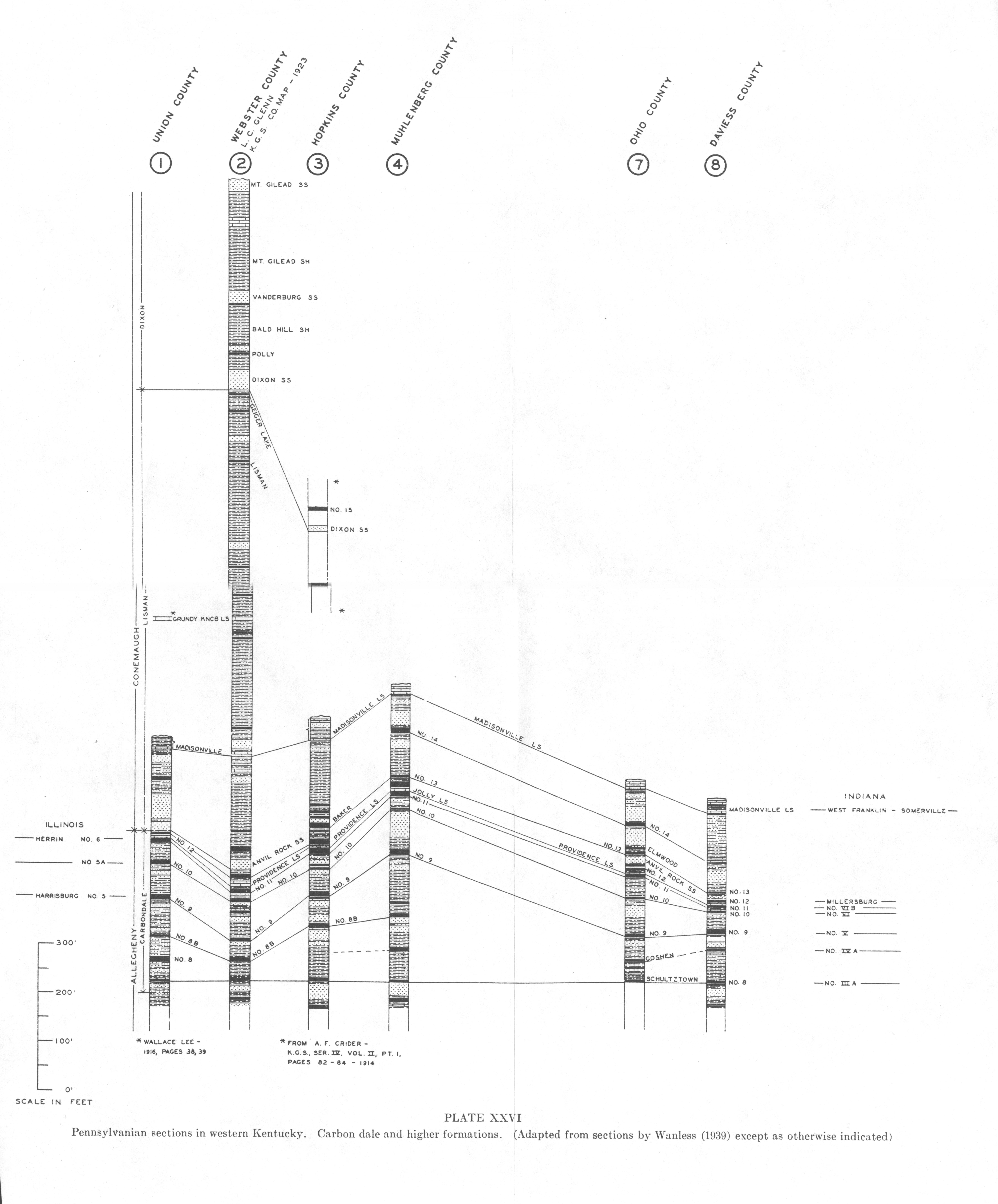
Carbondale (Lines, 1912; Shaw and Savage, 1912).—The Carbondale is the great coal-bearing formation of western Kentucky. It includes shales, sandstones, and some limestones, is bounded below by the base of the Sebree sandstone and above by the base of the Anvil Rock sandstone. Where the latter is locally absent, the boundary may be approximated with reference to No. 12 coal and the Providence limestone. Glenn (1912) formerly recognized two formational units, the Dekoven and Mulford separated by the No. 9 coal. The thickness ranges from 250 to 650 feet.
Sebree sandstone (Glenn, 1912).—A massive coarse-grained cliff-forming sandstone of the basal Carbondale. It has a thickness of 40 to 50 feet, locally only 10 to 12, and is the first coarse sandstone above the Caseyville. It is comparable to the latter in coarseness of texture, topographic expression, and persistence, and is mainly responsible for the rugged hills of the Rough Creek fault zone. Much of the cement is ferruginous and sand ironstone plates and seams are prominent. It is tentatively correlated with the Isabel and Browning sandstones of Illinois (Wanless, 1939).
Providence limestone (Glenn, 1922) = Jolly limestone (Hutchinson, 1912).—This is the most prominent limestone in the Carbondale and occurs within a few feet or immediately above the No. 11 coal. It is a persistent and valuable horizon marker, though locally thin and discontinuous. In Webster County Glenn gave it a normal thickness of 5 to 8 feet. Fusulina cylindrica though usually not common is rather consistently present (Glenn, 1922), and in Illinois it has gone under the name of Fusulina limestone. It is a blue argillaceous limestone, variable in composition and irregular in bedding. Wanless (1939) correlated it with the Brereton limestone of Illinois.
Lisman formation (Glenn, 1912).—The Lisman is defined as extending from the base of the Anvil Rock sandstone to the base of the Dixon sandstone. When the latter is absent the base is approximated at the "lowest one of a series of thin limestones or marly clays" (Glenn, 1922, p. 103). The thickness runs 900 to 1000 feet. It is a succession of soft shale, sandy shale, soft sandstone and occasional limestone zones. With the exception of the Baker (No. 13) and No. 14 coals in the lower part, coals are not of importance. The only important limestone member is the Madisonville.
Anvil Rock sandstone (Owen, 1856).—A coarse loosely cemented ferruginous usually massive and crossbedded sandstone which is locally conglomeritic. It is coarser than the Sebree which was described as the first coarse sandstone above the Caseyville. Glenn gives it a thickness of 20 to 40 feet in Webster County and Theis a maximum of 125 feet in Henderson County (unpublished manuscript, Ky. Geol. Surv.). Theis also has described this member as varying considerably in apparent stratigraphic position. Normally it occurs between the No. 12 and No. 14 coals. He found this sandstone locally replacing the upper Providence limestone, sometimes occurring above No. 12, sometimes below it, and sometimes splitting this coal in two seams. Its forming is thus a matter of the usual variation in number and direction of the distributaries building an alluvial fan or delta.
Madispnville limestone (Norwood, 1878).—This is an impure, blue to dark leaden grey earthy homogeneous to brecciated limestone. It is sparingly fossiliferous. In Webster and Hopkins counties the limestone occurs as three limestone ledges, each 7 to 9 feet thick, in a zone 25 to 40 feet thick, 200 feet above the base of the Lisman. Much of the inter-bedded shale is red, which is a convenient means of distinguishing it from the Providence. It is quarried at Madison ville for road metal.
The Madisonville limestone is correlated (Wanless, 1939) with the Lonsdale of Illinois and West Franklin of Indiana and tentatively with the Upper and Lower Brush Creek limestones of Ohio and Pennsylvania and Lenapah limestone of Kansas. It marks the highest appearance of Mesolobus and Prismopora.
Dixon (Glenn, 1912).—This includes the youngest of the Pennsylvanian of Kentucky and is bounded below by the base of the Dixon sandstone. It outcrops only in Webster and Hopkins counties and vicinity and has a maximum known thickness of 400 feet plus. Coal is not of importance. The following members are recognized by Glenn (1922):
(a) Dixon sandstone.—This is a medium- to fine-grained sandstone varying from massive and hard to seamed, soft, and even argillaceous. It is frequently cross bedded. A maximum thickness of 50 to 60 feet is known with a usual range of 10 to 30 feet.
(b) Bald Hill shale (from "Bald Hill" a mile east of Dixon, Webster County).—A shale formation, often marly, and lead to green in color with purplish mottling. Thin coals and limestones occur. In the marly phase nodules of iron carbonate and nodules and lenses of impure limestone occur. In some of these, vugs of fluorspar, galena, and sphalerite are found. Marine fossils occur in a few inches of marly shale or limestone overlying a thin coal at the top of the formation. The thickness varies from 60 to 125 feet.
(c) Vanderburg sandstone.—A medium- to coarse-grained sandstone, not well cemented, and usually 15 to 30 feet thick (maximum 60 feet). It has much the appearance of the Dixon sandstone.
(d) Mt. Gilead shale.—These shales exposed near Mt. Gilead School, Webster County, have essentially the same character as the Bald Hill shales. They become sandier in the upper 25 to 50 feet, weather to a rusty yellow, and end above in a soft sandstone, the Mt. Gilead sandstone member. The limestones are thin and inconspicuous with the exception of a local lens 2 miles southwest of Mt. Gilead which attains a thickness of 20 to 30 feet. The limestones are earthy or brecciated. Thickness, 150 to 200 feet.
(e) Mt. Gilead sandstone.—These soft sandstones, 20 to 30 feet thick, constitute the youngest known Pennsylvanian of the Western Coal Field. They are known from only a limited area in Webster County.
 |
 |
 |
| Plate XX Pennsylvanian stratigraphy of eastern Kentucky |
Plate XXI Pennsylvanian sections in northeastern Kentucky above horizon of Fire Clay coal (adapted from sections by Wanless (1939) except as otherwise indicated) |
Plate XXII Pennsylvanian sections in northeastern Kentucky below horizon of Fire Clay coal (adapted from sections by Wanless (1939) except as otherwise indicated) |
 |
 |
 |
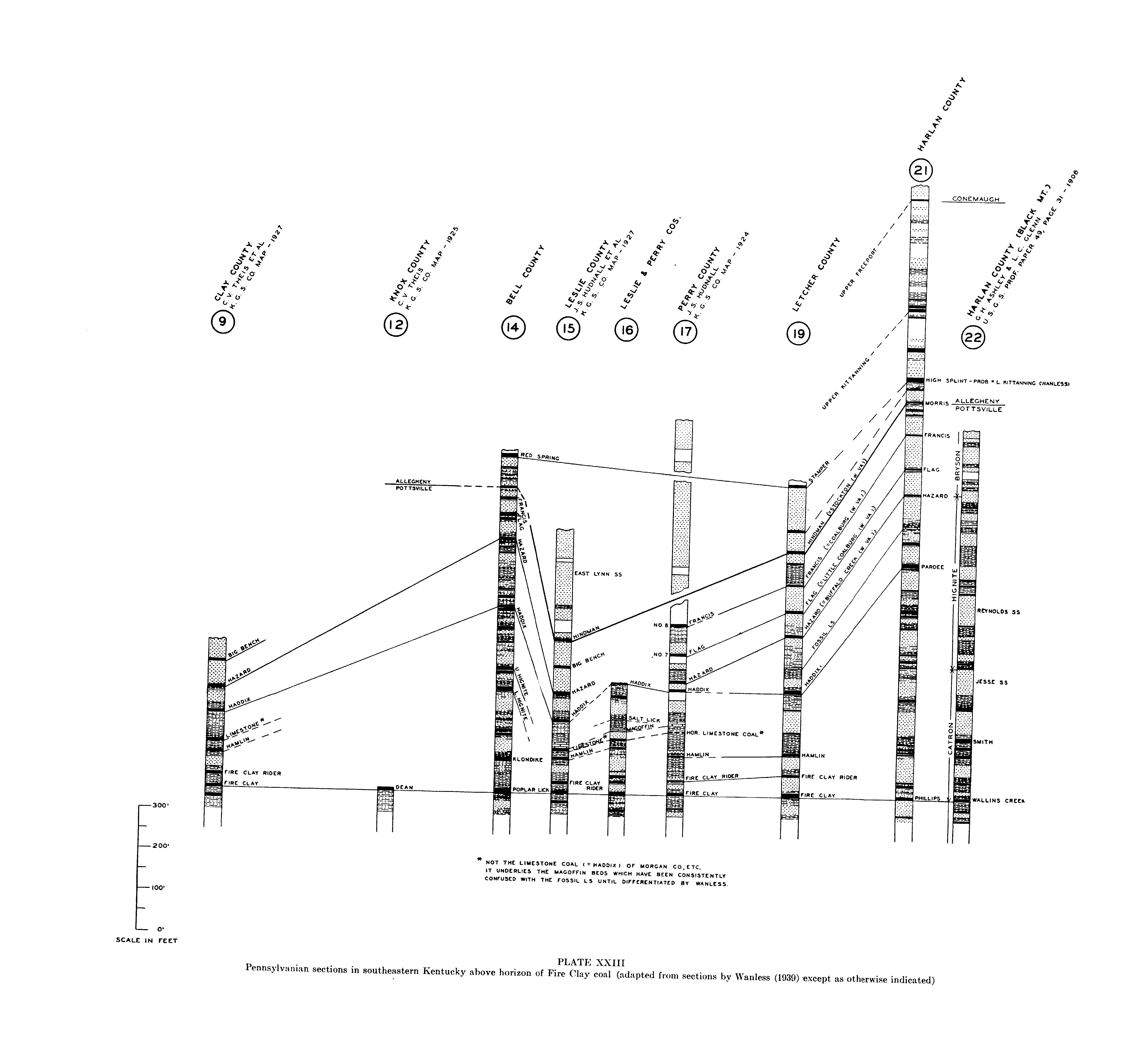
| Plate XXIII Pennsylvanian sections in southeastern Kentucky above horizon of Fire Clay coal (adapted from sections by Wanless (1939) except as otherwise indicated) |
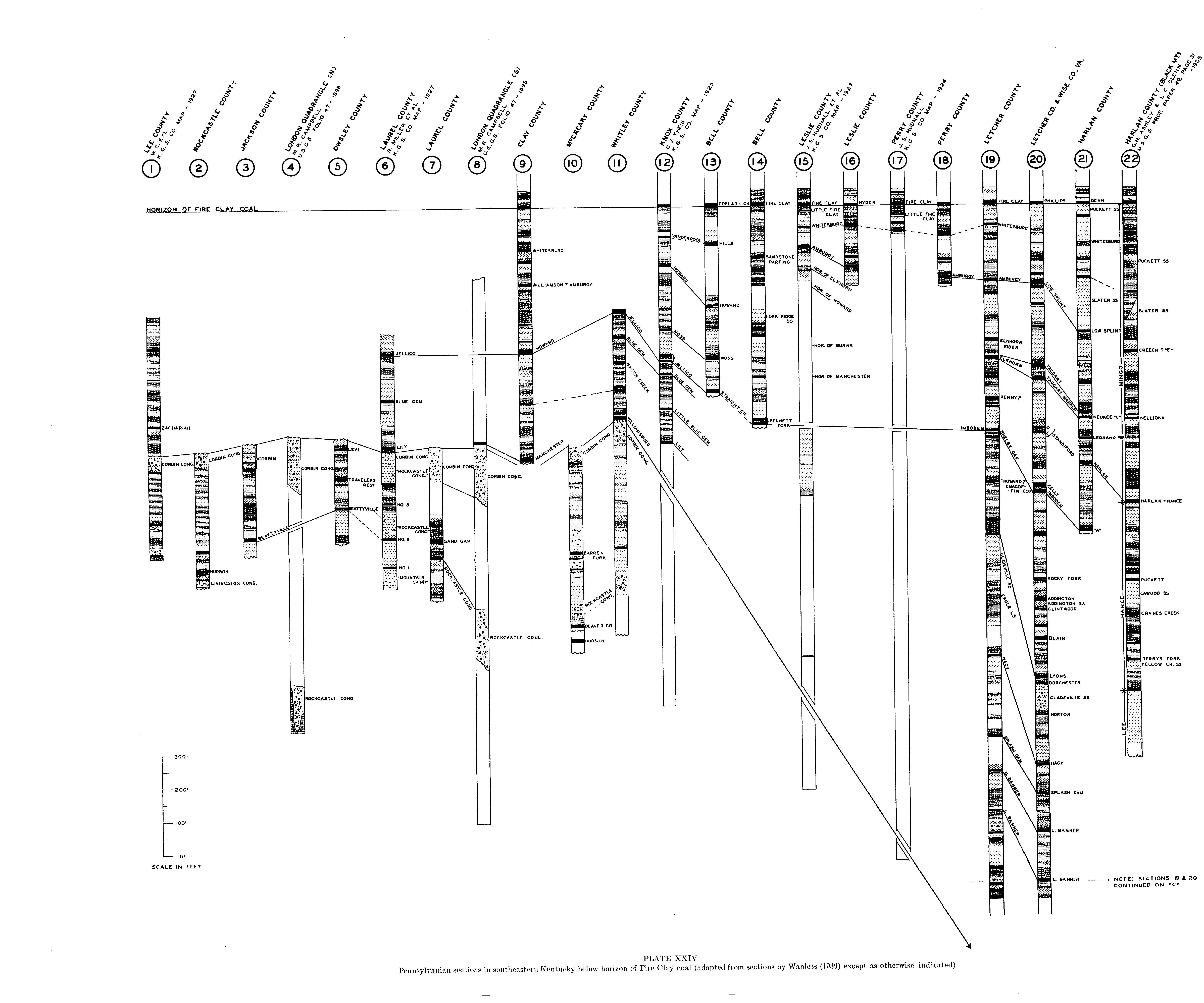
Plate XXIV Pennsylvanian sections in southeastern Kentucky below horizon of Fire Clay coal (adapted from sections by Wanless (1939) except as otherwise indicated) |
Plate XXV Pennsylvanian sections in southeastern Kentucky. Lower part of sections in Letcher and Wise counties, Virginia (adapted from sections by Wanless (1939) |
 |
 |
 |
| Plate XXVI Pennsylvanian sections in western Kentucky. Carbondale and higher formations. (Adapted from sections by Wanless (1939) except as otherwise indicated) |
Plate XXVII Pennsylvanian sections in western Kentucky. Caseyville and Tradewater formations. (Adapted from sections by Wanless (1939) except as otherwise indicated) |
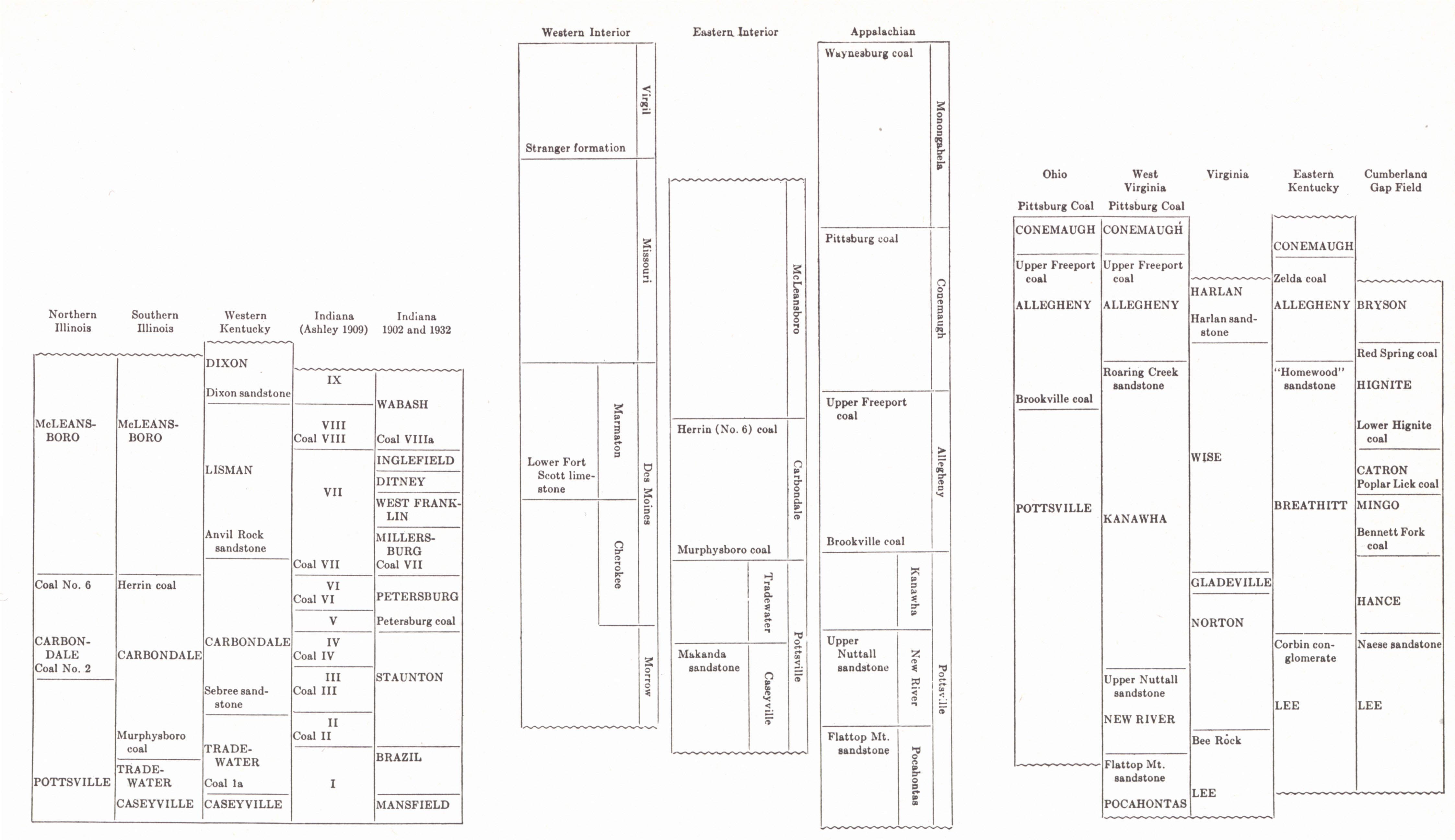
Plate XXVIII
Correlation charts of the major divisions of the
Pennsylvanian (Wanless, 1939) |
Footnotes
1 The reason for the use of the term seems to have varied with different workers. Stevenson referred to the immense number of bees present because of the laurel blossoms which cover it in the early summer. Others referred to the characteristically pitted surface developed on weathered cliff faces.