
In the following notes only the major events are outlined. Little attention is given to change in conditions indicated by varying lithology, and the numerous disconformities may be seen in the stratigraphic charts. Disconformity does necessarily imply emergence, either with or without notable erosion, often merely that of filling to the baselevel of deposition. Very little is known of the pre-Camp Nelson (pre-Stones River) record and this is outlined in Chapter I.
The early history of the Jessamine dome has been outlined on page 132 et seq. As indicated, there occurred early arching in the pre-Onondaga to form an early Jessamine dome, but the region was extensively submerged in the late Devonian and Mississippian. The Nashville dome in Tennessee also showed early and progressive arching, the evidence and nature of which Wilson (1935) has outlined.
|
|
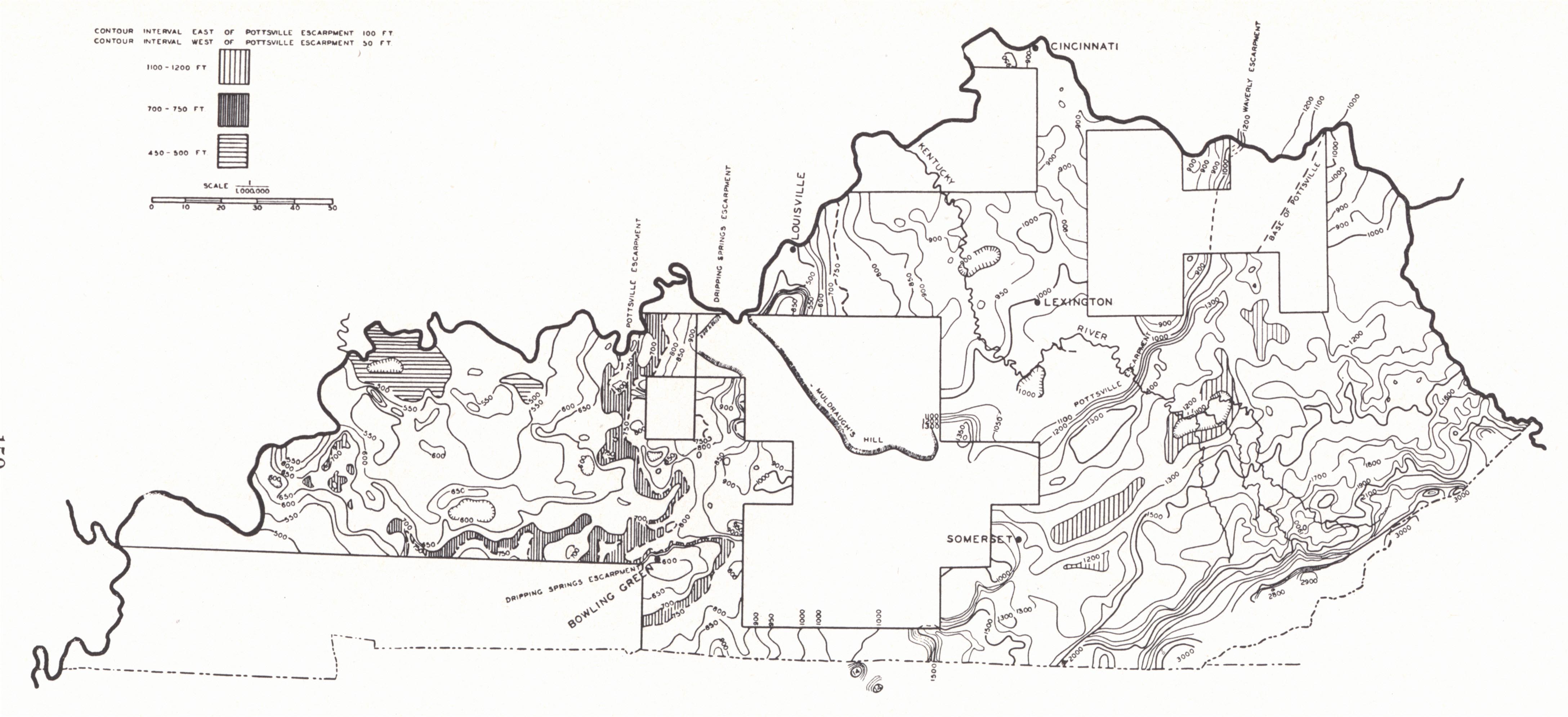
| Plate XXXVI.—Regional evolution of Kentucky landscape |
The Mississippian-Pennsylvanian Contact.—With the close of the Mississippian general uplift and emergence occurred in all areas where the contact between these two systems is exposed. It marked the change from persistent marine conditions to those of dominantly nonmarine. Marine zones are found in the Pennsylvanian of Kentucky but they are relatively few, and are more common in the Western Coal Field section than in the Eastern. The Mississippian-Pennsylvanian contact is one of the marked unconformities of the Paleozoic section.
Closing Events of the Paleozoic.—Associated with and as part of the Appalachian Revolution in the east, major structural features in the state were made or completed. These include: (1) The Pine Mountain over-thrust with associated faults and Middlesboro syncline; (2) The Cincinnati arch; (3) The Western coal basin; (4) The many fault systems including the Kentucky River, West Hickman, Irvine-Paint Creek, Rough Creek, faults of the western Pennyroyal, and others. Some of these may have originated earlier and continued later; (5) The Paint Creek uplift had a pre-Pennsylvanian origin, and though its main features were formed at this time more than one movement contributed to the making of the structure (p. 145).
Mesozoic.—The only sedimentary record of the Mesozoic is found in the outcrop of Cretaceous in "Between the Rivers" and the eastern margin of the Jackson Purchase. To the west it passes under cover of the Tertiary and Quaternary. It is represented by the Tuscaloosa and Eutaw formations interpreted by Roberts (1929b) as marine but by Twenhofel (1931) as the subaerial topset beds of delta deposits.
With this exception the record is one of erosion. Presumably the cycle regarded as terminating in the Fall Zone peneplain (Johnson, 1931) was involved, but there is no record of this surface which would correspond with the unconformity at the base of the Cretaceous system in the Purchase and vicinity. The Schooley peneplain (early Tertiary), though, is regarded as represented in Pine Mountain (with due allowance for residual monadnocks and later reduction by erosion) and in the Pottsville and Waverly escarpments bordering the Eastern Coal Field. With west and northwest tilt it is apparently represented in the crests of the succession of cuestas of western Kentucky and then within the sedimentary section of the Purchase.
With the completion of this cycle great thicknesses of Paleozoic strata had been removed, particularly in the regions of conspicuous uplift such as the Cincinnati arch and Pine Mountain overthrust. On the other hand, in areas of down warp as in the Western Coal Basin and east of the Arch, much of the Pennsylvanian section was preserved. This laid the ground work for the evolution of the present landscape through differential erosion.
Early Tertiary Uplift.—Uplift with westward tilt took place in the early Tertiary. This involved about 1000 feet in the Pine Mountain-Cumberland Mountain region of southeastern Kentucky, represented in the difference in elevation of Schooley remnants at 2600 feet to 2700 feet and Harrisburg remnants at about 1700 feet. Uplift in the Purchase region was little, perhaps a couple of hundred feet.
 |
|
PLATE XXXVII |
In the cycle inaugurated at this time1 peneplanation was accomplished in areas of weaker rock.
1. The greatest development of such a surface was in the Blue Grass region and extending outward into areas of Black shale and Waverly (New Providence—Borden) outcrop. This is referred to locally as the Lexington peneplain (Campbell, 1898) and is regarded as the equivalent of the Harrisburg of the Appalachians. It increased in size as the bordering cuestas retreated down dip.
2. The surface is represented in eastern Kentucky in lowlands just east of the Pottsville cuesta (pl. XXXVII) and in the extensive lowland at 900 to 1000 feet of Boyd and Lawrence counties and vicinity. This is the Worthington plain of Butts (1904).
3. In the Cumberland River region of Cumberland and adjoining counties which lies along the axis of the Cincinnati arch, the St. Louis limestone which caps the Pennyroyal surface has been stripped and the Lexington surface (Highland Rim peneplain of Tennessee) is shown in the accordant upland developed on the Waverly and Ft. Payne.
4. Within the protecting rim of the Western Coal Basin there is a corresponding accordant level over considerable areas broken by minor cuestas and strip plains, Theis2 has recognized such a formerly peneplained surface in Henderson County and referred to it as the Canoe Creek plain. He correlated it with Glenn's (1922) Henderson plain and referred it to the late Tertiary.
Uplift and Dissection of the Lexington Plain.—Uplift followed in the late Tertiary, again with northwest tilt. In the Cumberland Gap region this and later uplift have totaled about 1400 feet. The tilt is shown in the slope of the Lexington plain surface from 1050 feet in the southeastern Blue Grass to 900 feet at Cincinnati and 800 feet in Anderson County and vicinity. In the Western Coal Field it is materially lower. Theis3 gave an elevation of 560 feet in Henderson County (Canoe Creek plain). In central Kentucky the Kentucky River has trenched itself about 500 feet.
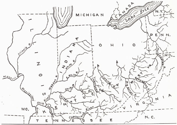 |
| FIG. 18. Sketch map showing old drainage systems that were combined to form the Ohio River (Leverett, 1929) |
The movement was not a simple one but involved: (a) an early minor movement recorded in the Parker strath, and Campbell’s intermediate valley of the Kentucky River and Irvine formation; (b) the main uplift; (c) a later minor uplift indicated by the trenching of the Scottsburg lowland around Louisville.
The Irvine formation (Campbell, 1898) consists of unconsolidated sand, gravel, and clay of alluvial origin occupying a high dissected terrace (inter-mediate valley) a couple of hundred feet below the hilltop level of the Lexington plain along the Kentucky River in eastern Madison County. Along and near the Ohio River and north of it similar straths are conspicuous, and these old valleys frequently deviate from the present stream valley. According to Fenneman (1938) they seem to be the same as Campbell’s "intermediate valley" of the Kentucky River and are commonly referred to as the Parker strath (Butts, 1904). In this region the old valley floors are covered by alluvium to depths of more than 100 feet, the great development of the alluvial fill here resulting from glacial obstruction of northward drainage and aggradation of overloaded streams from the melting ice. The Parker strath is pre-Kansan (Fenneman, 1938).
A pronounced flat is developed around Louisville at an elevation of about 475 feet, and below it the Ohio River has trenched itself to a depth of 100 feet plus. This is the Scottsburg lowland of Indiana geologists and is the result of more effective erosion on the weaker beds of the New Albany and New Providence formations. To what extent this surface may be recognizable elsewhere in the state the writer does not know, but it seems to be represented in the floor of the Nashville Basin, Tennessee.
This surface should be represented along other streams but little or no work has been done on it. Large bottoms well above normal flood waters are present. Attention should be called to large flats like those of the Red River near Stanton, the Licking River near Salt Lick, etc. These and others, though, are under structural control and have been developed by rapid widening in the Ohio and Waverly formations, while downcutting was held up by the underlying Boyle and other limestones.
Theis4, in outlining the physiographic history of Henderson County, recognized intermittent uplift of his Canoe Creek plain in Henderson County. "The territory was intermittently uplifted and the rivers cut terraces which now stand approximately 500, 440, 390, and 300 feet above the sea; after which the river degraded to a level of now about 200 feet above tide. This cutting took place entirely, or almost entirely, in late Tertiary time."
In the Blue Grass region rather recent rejuvenation is suggested in the convex profiles of valley sides, and in bottoms which seem to lie above normal floodplain level.
Pleistocene.—Significant events of Pleistocene history include:
(1) The Illinoian Ice Sheet reached Kentucky and has left scattered drift in the Ohio River counties from Oldham to Bracken. The drift, however, is not of sufficient thickness to materially influence topography or soil.
(2) There is evidence of a pre-Illinoian ice invasion. This is indicated by older drift at several localities and erratics far south of the recognized Illinoian border (p. 127).
(3) The Ohio River above the mouth of the Kentucky River came into existence as a result of ponding by an ice dam of northward flowing rivers, including the Licking and Big Sandy which, along with others, formerly drained toward the Great Lakes region. As now constituted, it is the product of the amalgamation of a number of more or less east-west tributaries of these ponded rivers as the backwater broke across low divides (cols) near the ice margin. Extensive readjustments of drainage followed the partial filling of these valleys by alluvium deposited in these temporary lakes.
(4) The Wisconsin Ice Sheet did not cross into Kentucky but aggrading of the Ohio valley by outwash together with extensive floods coming from the melting ice resulted in backwater in the rivers of western Kentucky. Sediment from the meltwater plus that brought in from the headwaters of these rivers filled the valleys to depths of 150 feet and more with sand, gravel, and clay, into which deposits the streams are now trenching themselves. These broad-bottomed, alluvium-filled valleys are common in and characteristic of the Western Coal Field and Purchase. The alluvial fill is probably Illinoian as well as Wisconsin, but the former has not been differentiated. The height of the Illinoian (600 to 620 feet at Cincinnati) and Wisconsin (540 feet at Cincinnati) fill in the Ohio River is sufficient to have ponded the waters of the Licking and Kentucky rivers far upstream.
Ohio River Drainage.—The Ohio drainage system is a composite of several systems that were in the pre-Pleistocene more or less independent. The general plan of this pre-glacial drainage pattern is shown in figure 18. The old Ohio terminated headward in the waters of either the Salt River or Kentucky River. There is some question in regard to the early course of the Kentucky. It may have flowed north paralleling the course of the Licking, Big Sandy-Kanawha, and others to the east and was thus not a part of the pre-glacial Ohio. As illustrated by the Big Sandy-Kanawha, draining north through the Scioto River valley (reversed), the natural effect of occupation of these valleys by glacial ice was to pond northward drainage until the ponded waters, attaining the height of the lowest col (outlet), overflowed one after the other westward to the adjoining basin, inaugurating and establishing a new course—that of the upper Ohio.
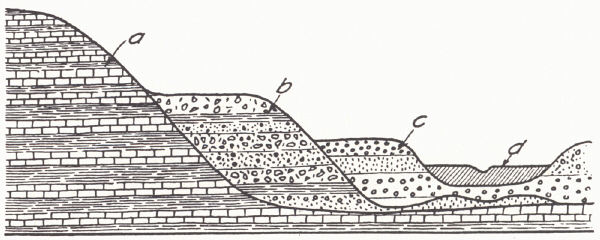 |
| FIG. 19. Glacial terraces of the Mill Creek
and Little Miami valleys, tributary to the Ohio River from the north near
Cincinnati, Ohio: (a) pre-glacial bluffs thinly covered with till; (b) interbedded till and outwash of the Illinoian glacial stage; (c) outwash of the Wisconsin glacial stage; (d) recent alluvium (Fenneman, 1916). |
The Ohio River had followed this new course for a long period prior to the advent of the Illinoian glaciation. Along the Upper Ohio, Kanawha, and Allegheny, Leverett recognized an old gradation plain, both terraces and abandoned valley sections, 200-300 feet below the upland.5 These old valley floors here carry a pre-Illinoian drift, perhaps Jerseyan, and remnants of such gradation plains are recognized down the Ohio valley and along some of its tributaries as far as Hancock County. Diversion of the old drainage lines to form the Upper Ohio attended or followed this early glaciation and along the new course an inner valley was subsequently cut 200 feet or more below the level of the old. Illinoian drift is widely present along the new valley. To what extent it was regional uplift or the enlargement of the drainage area that caused the trenching is not clear but certainly the latter is at least in part responsible.
During the stage of ponding, silt deposits accummulated in the valleys, conspicuously so in southeastern Ohio, West Virginia, and northeastern Kentucky. The filling by silt was in places so great that with reestablishment of drainage it followed new paths along low passes to the side; thus, Teay's Valley (West Virginia) and the abandoned valley behind Ashland, Kentucky (Tight, 1903; Phalen, 1912). The drainage of the Scioto River only in part follows 'the old valley and is reversed in direction.
In establishing a course southwest of the Scioto the Ohio River made use of an old tributary of the Big Sandy heading near Manchester, then of a tributary of the Licking to the mouth of the Little Miami east of Cincinnati, and then north to Hamilton, where it entered the present valley of the Big Miami River. From here. its course is subject to dispute. Leverett and Fenneman follow James (1888) in the belief that it turned south to the mouth of the Big Miami and thence along its present course westward. Exception to this was taken by Fowke (1898 and later) and Malott (1922, p. 137) who recognized a divide at Madison, Indiana, "which would place the head of the pre-glacial Ohio on the Muscatatuck regional slope between the Muscatatuck River on the north and the Salt Creek of Kentucky on the south." The Kentucky River was regarded as having turned northeastward at Carrollton to follow the Ohio and Big Miami valleys (reversed) to Hamilton, where, joined by the upper Ohio Licking drainage, it continued to the north. Evidence supporting this is outlined by Malott (1922):
1. Beveling of the upland toward the Kentucky River and its northeast pre-glacial continuation. This is not shown in the vicinity of Madison.
2. The characteristic cherty gravels (Irvine) are developed on the uplands along the Kentucky River and to a lesser extent the Licking. These are not known in the vicinity of the postulated Madison divide. It is reasonably assumed that if Madison had been downstream from the Kentucky River such gravels would have been carried there.
3. Barbed drainage along the Ohio River above Madison as well as the narrow valley with limited dissection by tributaries at Madison. Contradictions in the bed rock slope of the Big Miami may be explained by post-glacial uplift to the north.
The Licking may have maintained its old course northward from Cincinnati through the present Mill Creek Valley to the time of the Illinoian glaciation (Leverett, 1929). The development of the direct course of the Ohio from the mouth of the present Little Miami to that of the Big Miami is commonly regarded as having resulted from Illinois glacial ponding, during which time divides between the "Little Miami" and Licking and the Licking and "Big Miami" were broken through. Leverett (1929), though, recognized the possibility that it may have come through normal stream erosion, perhaps considerably pre-Illinoian.
Though the Ohio Valley and its tributaries seem to have been opened to their full depth prior to the Illinoian, that ice sheet transgressed the Ohio River Valley to such an extent that there could not have been free drainage down the valley in the part above Louisville. In this region though there seems to be no line of displaced Ohio River drainage at or near the border of the drift (Leverett, 1929). This may have been a matter of lower altitude and hence less active drainage, and supports the idea of post-glacial uplift.
Below Louisville there is little known that is referable to the Illinoian. It is regarded probable that the Illinoian terraces here do not rise above the level of the later Wisconsin fill.
The Ohio River was an outlet for several lines of glacial drainage in Wisconsin time and valley bottoms were built up by outwash along the entire course of the river. The filling seems to have been somewhat higher at and below the mouths of tributaries. At the mouth of the Big Sandy it stands at 600 feet (114 feet above present low water). At Cincinnati contributions from the Little Miami and "Mill Creek" have built it up to 540 feet, and it is on this outwash terrace that downtown Cincinnati, Newport, and Covington stand. The city of Louisville rests on a similar outwash plain at 460 feet with what are apparently former natural levees reaching 500 feet. Theis recognized two terraces (valley fills) of probably early and late Wisconsin respectively and also an earlier, much eroded, possibly Illinoian terrace on both the Ohio and Green rivers. The former lie at 380-395 feet and about 370 feet (about 10 feet above the present floodplain). In the 650 miles along the course of the Ohio River in Kentucky the Wisconsin fill shows a drop of 250 feet and at low-water the Ohio River a drop of 220 feet.
The greater part of the fill is sand and gravel, though the latter is seldom seen in outcrop. The upper 15 to 25 feet is usually rather fine and some of it is suitable for molding sand. Some clayey beds are unique in the presence of large and small stones suggesting till, but were regarded (Leverett, 1929) as probably coarse material floated down in ice blocks and deposited in the clay. In the lower Ohio Valley polished cherty Lafayette gravels are incorporated. At Cincinnati Fenneman (1916) noted 10 to 15 per cent of igneous and metamorphic rock in the Wisconsin outwash as contrasted with not more than 1 to 2 per cent in the Illinoian.
Alluvium-Filled Valleys of Western Kentucky.—The valleys of western Kentucky and adjoining parts of Indiana and Illinois, are considerably deeper than indicated by their present floodplains. The latter constitute the surface of an alluvial fill 100 to perhaps 200 feet deep, which is continuous with the higher Wisconsin terrace of the Ohio River. The Green River with its exceptionally wide and flat alluvium-floored valley far up to its headwaters is particularly conspicuous. Rising above these alluviated bottoms are isolated "island hills" of bedrock. The valley width itself is a matter of effective erosion of the weak shales of much of the post-Caseyville Pennsylvanian. These alluvial plains constitute about one-fourth of the area of the Western Coal Field.
The material consists of blue sticky clays and silts of the general nature of glacial rock flour along with sand which is often cross bedded and a scattering of igneous and metamorphic pebbles. The material is coarser nearer the river and finer up the tributaries.
Possible explanations of this fill include deposition due to: (a) regional depression, (b) overloaded glacial flood waters, and (c) coastal extension of the Gulf of Mexico.
1. In regard to the latter, the Gulf Coastal Plain has grown notably since the early Pleistocene. The delta of the Mississippi has extended the coastal plain about 125 miles, and the length of the course of the river across this delta is 300 miles (Malott, 1922). Its former mouth is regarded to have been near the mouth of the Red River, now more or less 50 feet above sea level. The gradual raising of the level of grade through lengthening must have been in part responsible for the fill.
Leverett (1921) ascribed valley filling in the Mississippi Valley to lengthening of the lower course of the river by delta building along with alluviation by glacial outwash.
2. Lee (1916) recognized continental subsidence, probably to a considerable extent during the Ice Age, as the cause. Malott (1922) regarded regional depression as having taken place. Theis6 regarded "depression unnecessary and in some respects untenable." The region, though, is a badly faulted one, and as suggested by the New Madrid earthquake of 1811 and 1812 movements have apparently continued into the present.
3. Alluviation by glacial waters has been regarded as an important cause of valley filling by Malott (1919; 1922) and Leverett (1929), and a sufficient cause by Theis. The Ohio and other major streams draining the glacier-occupied region were built up by valley trains deposited by glacial flood waters. Ponding of tributaries from the south by the aggrading of the main valley added to backwater from the flooded main streams resulted in their alluviation. The filling of Green River and other tributary streams was in part normal material brought in from the headwaters and in part material brought in by the glacial backwater. Corroborating evidence is found in: (a) continuity of the alluvial flat with the Ohio River Wisconsin terraces; (b) presence of pebbles and sand in the alluvium which are distinctively glacial in derivation; (c) the decrease in altitude upstream of the fill near the mouths of the streams as well as the localization here of coarser material and the development of torrential cross-bedding (Theis7).
With the surface of the valley fill more or less continuous with Ohio River terraces referred to the Wisconsin, the age of at least the observable portion of the fill is established. Theis recognized two terraces in Henderson County 10 to 15 feet apart referred to early and late Wisconsin but recognized the possibility that the upper may be Illinoian. He observed some suggestion of an earlier fill 20 feet higher. Leverett (1929) noted the absence of anything very suggestive of the Illinoian downstream from Louisville and presumed that the two fills more or less coincided. Malott (1922, p. 139) took the position that "most of the valley filling probably took place some time before the Illinois glacial stage, though no doubt some valley filling was associated with both the Illinois and Wisconsin glacial stages."
At present the Ohio River is aggrading in the building of natural levees. They antedate white man8, hence are not the result of overloading because of deforestation. At the same time the river at places is cutting into one of the rock shelves. This is the condition at the Falls of the Ohio.
Deficient Trenching in the Blue Grass.—The trenching of the Ohio River below its early Pleistocene valley floor (Parker-Irvine) has been regarded as in part the result of enlargement of drainage as well as uplift (p. 162). The Licking, Kentucky, and other major tributaries are similarly trenched through the Blue Grass and more or less throughout their course. Some tributaries of these streams, though, still flow in broad valleys at about the level of their old gradation plains and are trenched only for a few miles back from their junction with the main stream. Elkhorn Creek, tributary to the Kentucky, is an example, only the lower 7 or 8 miles showing material trenching. A similar contrast is shown between the South Fork of Licking (restricted to Blue Grass) and the main valley of the Licking River (Leverett, 1929). The suggestion has been advanced by Jillson (personal communication quoted by Leverett, 1929) that streams restricted to the Blue Grass with its limestone and shale are not equipped with the adequate cutting tools (sand) in contrast to the main streams, which head in the sandstone country of the Eastern Coal Field. The considerable underground drainage of the Blue Grass as a limestone region may be a factor.
Footnotes
1 In parts of Pennsylvania, West Virginia, and eastern Ohio there is recognized
an old erosion surface of uncertain status referred to as the Allegheny
Peneplain (Ashley, 1933. For discussion see Fenneman, 1938, pp. 296-298). It is
developed within the basin margined by Pocono (east) and Pottsville-Waverly
(west), of which the outward facing cuestas are regarded as approximating the
old Schooley surface. On the east the vertical interval between it and the
Schooley is 1000 feet; on the west the two essentially coincide. Whether this
coincidence of level in the west is to be interpreted as indicating a second
baseleveling or failure of uplift to involve the western region in the second
cycle is uncertain. It does not seem to be a significant feature in the
development of Kentucky topography and has not been recognized in Kentucky.
2 Geology of Henderson County, unpublished manuscript, Ky. Geol. Surv.
3 Ibid.
4 Ibid.
5 Not to be confused with the Irvine etc. strath of the late Tertiary.
6 Geology of Henderson County, Kentucky, unpublished manuscript, Ky. Geol. Surv.
7 Ibid.
8 Ibid.