County. The outcropping rock is a part of the Lexington.
summit level is that of the Lexington peneplain (Caufield and Shook).
shales near Agawam Station, 7 to 8 miles southeast of Winchester.
The Blue Grass region is the central lowland, characteristically the region of Ordovician outcrop but some areas of Silurian and Mid-Devonian limestone are included. Marginal portions of the lowland underlain by the Ohio-New Albany and Waverly shales are not included. It is a limestone country, typically a rolling upland in the youthful stage of dissection with an accordant upland level of about 1050 feet in the southeast which slopes to about 900 feet at Cincinnati and 800 feet or less to the northwest. This upland level is the slightly tilted and somewhat reduced Lexington peneplain surface below which the Kentucky, Ohio, Licking, and other rivers have trenched themselves to depths of 400 to 500 feet. Lowering without material modification of the upland level has been accomplished by solution, and the extent of this work is suggested by the deep residual soils.
| PLATE XXXVIII | |
|
|
|
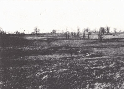
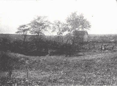
| FIG. 1. Inner Blue Grass scene on the Harrodsburg Pike south of Lexington. | FIG. 2. Limestone sink and
cave near Burgin in southern Mercer County. The outcropping rock is a part of the Lexington. |
|
|
|
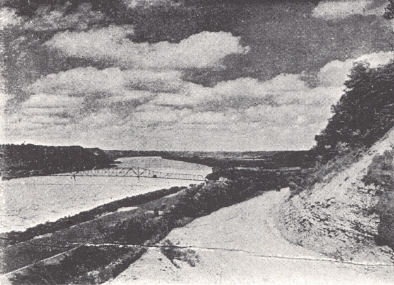
| FIG. 3. Ohio River scene in
northern Trimble Countv. The accordant summit level is that of the Lexington peneplain (Caufield and Shook). |
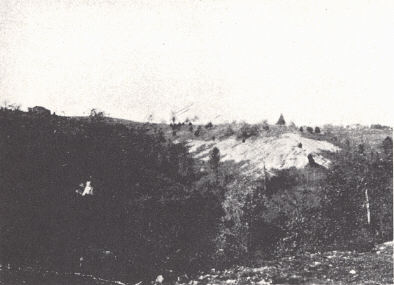
FIG. 4. Rapid erosion in the
Richmond (Waynesville and Liberty) shales near Agawam Station, 7 to 8 miles southeast of Winchester. |
The Blue Grass, however, is not coextensive with the area of Lexington peneplanation as the latter extends into areas of upper Devonian and Mississippian rocks, and along the Ohio and Big Sandy rivers into the Pennsylvanian. This outer part of the central lowland, though differing from typical Knobs country in altitude and topographic position, has similar soils, some elements of topography, and the general living conditions of the Knobs and that part of the Eastern Coal Field involved.
The surface is mildly karst and gently rolling, except in the vicinity of large streams where the topography is mature and distinctly rough. In the extensive interstream areas with a minimum of soil erosion, deep residual limestone soils of great fertility have formed and are responsible for the agricultural value of the region. Streams follow intrenched meanders. Along the Kentucky River an intermediate valley floor is found in the lower hilltop level 150 to 200 feet below that of the Lexington plain. Deposits of the Irvine formation rest on this well-dissected terrace. Similar valley floors with alluvium, some now abandoned, are found elsewhere near the larger streams and the present stream courses in places deviate from the older valleys. Fenneman (1938) figures such an abandoned valley formerly occupied by the Licking River above Falmouth.
The Blue Grass was the earliest part of the state settled and one of the first regions west of the Appalachians to be developed. Early settlers came mainly by the Wilderness Trail through Cumberland Gap, less commonly by the Ohio River. With the erection of a block house at Maysville (Limestone) in 1704 this latter route developed into the main route of travel. In the census of 1790-95 all Kentucky towns were either within or on the margin of the Blue Grass.
Large springs are common and the location of a number of towns— Harrodsburg, Lexington, and Georgetown—were originally determined by them. Of importance were the "salt licks" of which Big Bone Lick near the Ohio River in Boone County and the Upper and Lower Blue Licks of Nicholas County are the best known. Pleistocene mammals, attracted by the salt and mired in, have left an exceptional fossil record.
Three sections are recognized:
Inner Blue Grass.—The extent of this central division, constituting about 30 per cent of the whole, is essentially the extent of the outcrop of the Lexington and Cynthiana limestones. Narrow strips of outcrop along the main valleys are of course subordinate to the main outcrop. Thus such narrow belts of Cynthiana and Lexington occur along the Kentucky River within the general area of Eden outcrop. A relatively small area of Stones River-Lowville (High Bridge) outcrop occurs in the central part and gives rise to its own characteristic rugged topography. The Cynthiana also shows considerable regional variation in character. There are many areas where shale is dominant so that at least a part of the area of Cynthiana outcrop is essentially Eden in character.
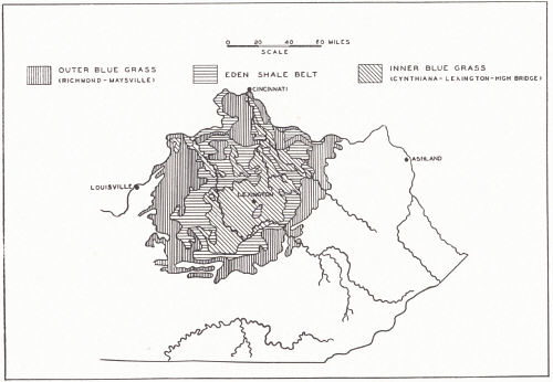 |
| FIG. 20. Divisions of the Blue Grass region
of Kentucky as determined by outcrop pattern. The map shows only Ordovician outcrop, but the Outer Blue Grass, as commonly recognized, includes the area of Mid-Silurian and Mid-Devonian outcrop in the vicinity of Louisville and to the east and south. |
In its typical development the Inner Blue Grass is a region of exceptional agricultural merit due both to topographic character and to the fertility of the residual soil. Lexington limestone soil is highly productive, particularly that derived from the Woodburn formation. This is a highly phosphatic limestone yielding a phosphate-rich soil. The gentry rolling topography has held soil removal to a minimum and a thick residual soil has accumulated which shows considerable local variation in character. The Brannon limestone produces a cherty clay soil and gullies easily. The Curdsville and Faulconer also produce an abundant chert residuum.
The immediate vicinity of large streams is marked by a mature topography with steep slopes and narrow divides which broaden as the river is left behind. In the area or the High Bridge outcrop these massive limestones have produced the rugged landscape of the Kentucky River gorge country. Streams occupy narrow meandering gorges bordered by vertical cliffs. Displacement along the Kentucky River fault through a considerable part of this area causes the river to swing from Lexington outcrop to High Bridge and back, forming and occupying a gorge in the latter and a valley of moderate width with considerable bottom land in the former. High Bridge and Dix Dam and Lake Herrington are located along this gorge.
Eden Shale Belt.-- The bordering outcrop of Eden shale has given rise to a region of similar or slightly higher altitude but different aspect. Some of the area of outcrop of Cynthiana limestone, as already pointed out, and also some of the lower Maysville is better allied with this belt than with the Inner or Outer Blue Grass. The comparatively impervious and easily eroded shale has produced an angular mature topography—a rough hilly country not unlike that of much of the Cumberland Plateau on a small scale. Smaller tributary valleys are generally narrow and V-shaped and divides are narrow. Where capped with sandstone (Garrard), they are more rounded. When kept under cultivation these steeper slopes erode rapidly, the shale is removed and slabs of the intercalated limestones are left scattered over the surface. Main streams have developed broad bottom lands. It is a region of inferior soil, steep slopes, and rapid soil wash (mature topography)—a region inferior in character to that on either side. Davis (1927) expressed doubt that 25 per cent of the area can be cropped permanently and profitably. On the other hand some of the highest priced tobacco is raised on Garrard sandstone hills.
To the north the Eden area is 10 to 30 miles wide, 5 to 10 miles wide on the eastern and western side, and to the south quite narrow. The narrowness of the zone here is a matter of faulting and steeper dip. Degradation in this division has been accomplished by stream cutting rather than by solution.
Outer Blue Grass.—This is the region of Maysville, Richmond, and younger outcrop, topographically, similar to the Inner Blue Grass but with soils of somewhat lower fertility. It contrasts with the Eden shale belt on one side and the hilly country of the Knobs on the other. It is more desirable than the Eden belt but somewhat less so than the Inner Blue Grass.
In the northern part a narrow belt was involved in the Pleistocene glaciation. However, the amount of drift is small, and it is not the topographic or geographic factor here that it is farther north. The Richmond in the east and south involves a large amount of shale. These together with the extensively developed Crab Orchard shales (Clinton) east of the Arch again give something of a regional aspect of Eden or Knobs. Around Louisville extensive limestones of the Mid-Silurian and Mid-Devonian ally this country with the Blue Grass.
In western Oldham and eastern Jefferson County (near the eastern margin of the Prospect and Louisville quadrangles) the upland level (Lexington plain) with an elevation of 800 feet slopes rapidly westward forming what in Indiana (Malott, 1922) has been called the Muscatatuck regional slope to a lowland flat at about 500 feet. This is of limited extent in Kentucky and is known as the Scottsburg lowland. The slope is under structural control and constitutes a stripped plain on the relatively resistant Louisville and Jeffersonville limestones from which the New Albany and New Providence shales above have been stripped.
General.—Maximum development of the Blue Grass to the north and west is a matter of lower regional dip. In all of these divisions limited but variable amounts of alluvial land border the courses of the main streams.
According to Davis (1927) 76.4 per cent of the Blue Grass land is improved against an average of 54.3 per cent for the state. Of unimproved land the bulk of it is either marginal to large streams or in the Eden shale belt. The original virgin forest had a valuable stand of hardwood, particularly walnut. Existing forest resources are limited.
Mineral resources are relatively unimportant. Limestones for all purposes are widespread. Phosphate rock has been mined. Mineral veins of barite, fluorspar, calcite, galena, and sphalerite have been worked and more recently some mines have again been opened. Ordinary brick clay is widespread and pottery clay (Irvine formation) is used in Madison County. Mineral waters have been commercialized at Dry Ridge in Grant County.
Outliers.—In addition to isolated knobs extending into the margin of the Blue Grass and other irregularities of this border, there are a number of unusual areas locally developed in some of these divisions, determined by structural conditions.
(a) A narrow Eden shale belt follows the West Hickman (Lexington-Maysville) fault east of Lexington. The Eden is preserved in a graben and gives rise to a narrow zone of "Eden" country within the Inner Blue Grass, locally known as the Beech Ridge, and often explained as an old buffalo trail.
(b) The Switzer fault gives rise to a similar area southwest of Georgetown.
(c) Burdett Knob, Garrard County, is an isolated though otherwise typical knob formed of Ohio and New Providence shale, located on the crest of the Jessamine dome. It is a remnant of these younger rocks preserved in a downfaulted block of the Kentucky River fault zone in a region of normal High Bridge and Lexington outcrop (see p. 148). A number of other isolated occurrences of Ohio shale preserved locally in a similar manner are known.
(d) Jeptha Knob is a Silurian outlier (equally well an older Ordovician inlier) in central Shelby County. Here flat lying Middle Silurian dolomitic limestone caps a structure described elsewhere as cryptovolcanic (p. 153).
 |
 |
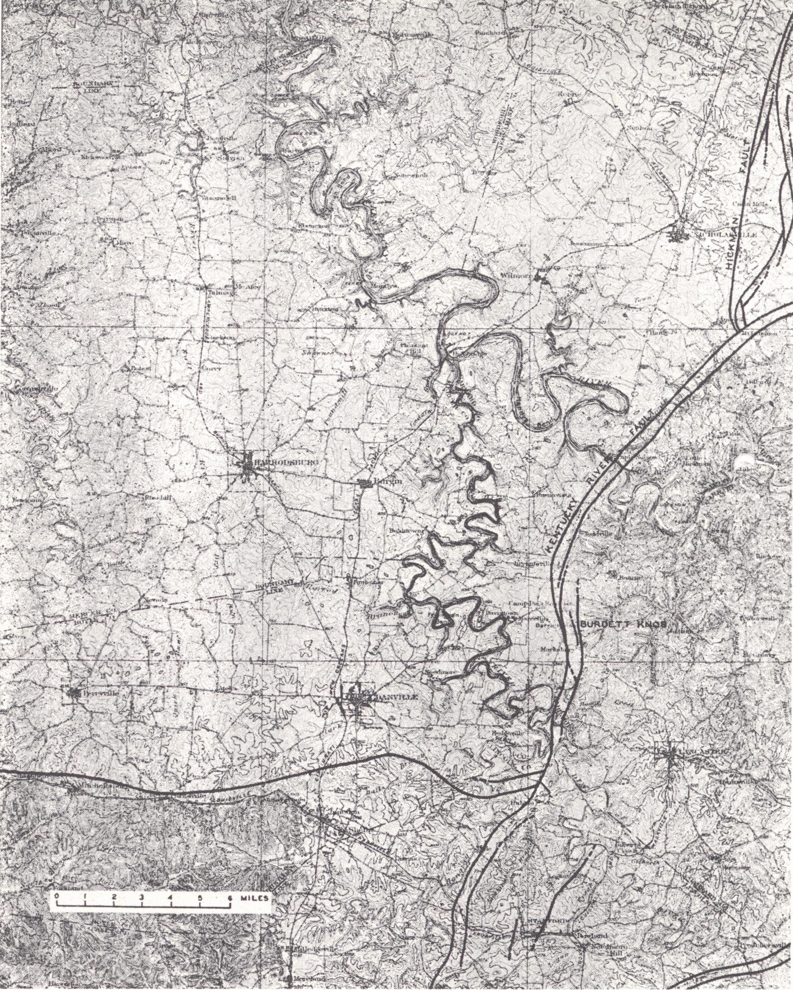
| PLATE XXXIX
Harrodsburg topographic sheet (± X ⅓) |
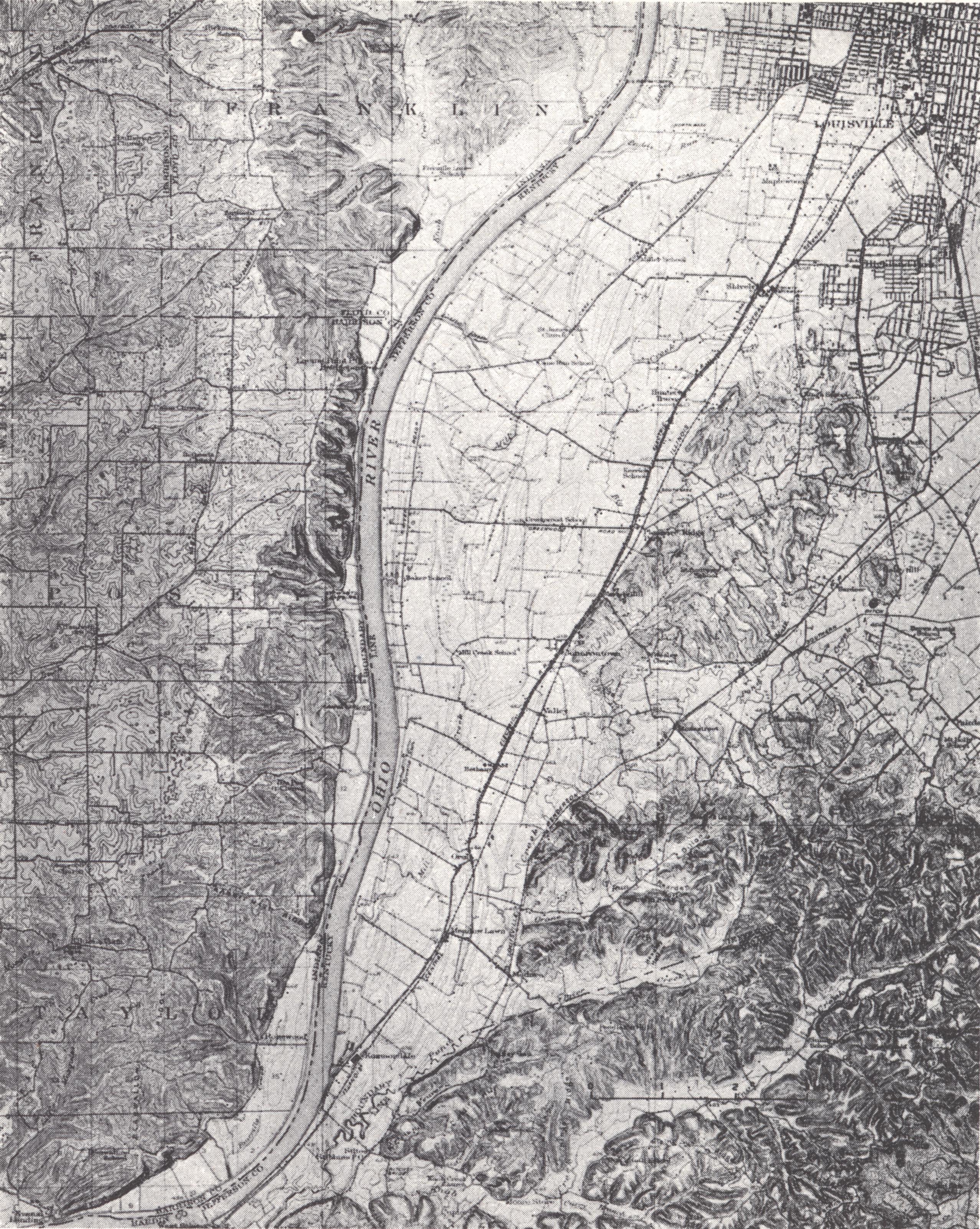
PLATE XL
Kosmosdale topographic sheet (± X ⅓) |