As implied by the name, the Mississippian Plateaus area is the region of Mississippian outcrop, particularly the middle and upper parts of the system, but it is better defined by its topographic boundaries. It forms a broad belt to the west and south of the Blue Grass, separated from that region by Muldraugh's Hill and the belt of Knobs. To the east in Rockcastle County Muldraugh's Hill merges with the Pottsville Escarpment, eliminating the Mississippian Plateau as a distinct unit northward along the eastern margin of the Blue Grass. Here the massive limestone succession of St. Louis, Ste. Genevieve, and Chester is separated from the Rockcastle conglomerate by only a thin zone of Pennington shale, and along with the Rockcastle constitutes the cap rock of a single cuesta. To the north in Lewis County and vicinity the limestone thins and is frequently missing. Here also the Cumberland-Allegheny Plateau is bounded on the west by the Waverly Escarpment, and the zone of Mississippian outcrop to the east of it is included in this plateau. In western Kentucky the Mississippian Plateaus include the region between Muldraugh's Hill and the Pottsville Escarpment.
|
|
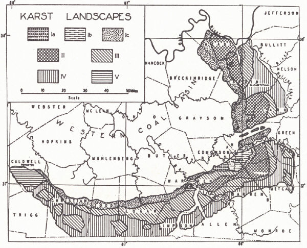
| FIG. 21. Divisions of the Mississippian Plateaus (Dicken, 1935) |
The Mississippian Plateaus stand as a pair of inward-facing cuestas rising above the Blue Grass and separated from the latter by the wider or narrower zone of erosion remnants constituting the Knobs. The lower of the pair, the Pennyroyal, is the surface of a cuesta developed on the outward-dipping St. Louis limestone, locally broken through to show an accordance of summit level representing the Highland Rim or Lexington peneplain. The higher cuesta, forming the Mammoth Cave Plateau, is carved on the Cypress sandstone and has a "Knobs" border of Ste. Genevieve and Lower Chester hills with or without the sandstone cap. It is developed only in a belt surrounding the Western Coal Field.
Though varying widely in character, the region has a unity in the extensive development of solution features.
According to Sauer (1927) the geographic identity of the area is best expressed as a corridor (reference is to the Pennyroyal). Bounded by rugged hills (Dripping Springs Escarpment and Mammoth Cave Plateau) on the one side and the "Brakes" (Knobs) on the other, it constitutes a double corridor—one south from Louisville, the other east from the Purchase—connecting the Ohio Valley with Tennessee and states to the south. The early pioneer trails are now followed by the principal highways of the region, U. S. 31E and U. S. 31W. The Louisville and Nashville Railroad south of Louisville follows the rolling lowland east of the Dripping Springs Escarpment.
| PLATE XLV | |
 |
 |
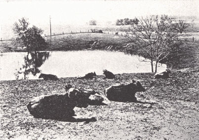
| FIG. 1. Karst landscape in the
Pennyroyal of Hart County (Caufield and Shook). |
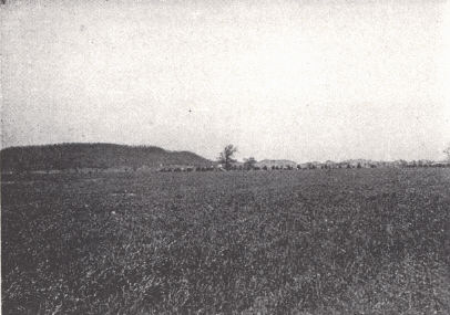
FIG. 2. Landscape in the
Pennyroyal near Bowling Green, Warren County. The flat topography is controlled by the St. Louis limestone. |
 |
 |
| FIG. 3. Outlying Knob of the
Mammoth Cave plateau and sink in the Pennyroyal between Cave City and Glasgow Junction. |
FIG. 4. Muldraugh's Hill
between Bardstown and Elizabethtown. This is the St. Louis cuesta. |
Pennyroyal.—In its typical development the Pennyroyal is a rolling upland plain sloping with the dip of the rock-a stripped plain on the St. Louis limestone capping the lower cuesta. Local relief is small. The topography is karst, dotted with limestone sinks. Drainage is under-ground except for the few larger rivers, and surface drainage is commonly dismembered—a region of lost rivers. Though caves occur, the main cave region lies behind the Dripping Springs Escarpment. Occasionally one, such as Mammoth Onyx Cave, occurs in an outlying knob.
A large part of the area was without trees when settled; hence, the oft-used term "Barrens." It is comparable to the Blue Grass in many respects. The level to gently rolling landscape of the typical Pennyroyal and lack of surface drainage are favorable to the development of a thick residual soil. The soil itself is not unlike that of the Blue Grass region though regarded as somewhat inferior. Residual sand from the Cypress is present in abundance along the margin near the Dripping Springs Escarpment, and some of it finds its way into the underground circulation as shown by extensive deposits in the caves. Residual chert and flint from the St. Louis and Ste. Genevieve limestones are abundant.
In the vicinity of Muldraugh's Hill stream dissection has produced a rough topography and conditions are much like and grade into those in the adjoining Knobs. Near the Dripping Springs Escarpment sandstone-capped (Cypress) limestone knobs rise above the Pennyroyal level. The cuesta itself is referred to by Dicken (1935a) as a "solution cuesta," i.e., the cuesta is the result of solution rather than of mechanical wear of streams. The lack of active surface drainage, the fact that the underlying limestones are more resistant to mechanical erosion than is the Cypress sandstone, and the abundant sand residuum near the Escarpment all point to solution as the dominating process. Similar knobs border the Pottsville Escarpment in the southeast. In southern Casey County in the southern Pennyroyal a Pottsville-capped limestone (Ste. Genevieve-Chester) knob, known as Green River Knob, is regarded as indicating the former extent of these beds across the Cincinnati arch.
An eastward projection of the Pottsville border of the Western Coal Field in northern Green, Taylor, and southern Larue counties divides the Pennyroyal into two sections. Sauer (1927) referred to the section to the north as the Elizabethtown area. It is not so conspicuously smooth as farther south in the more typical Pennyroyal and is in places distinctly hilly. This Pottsville strip is an erosion remnant of Pottsville, a former valley fill in the pre-Pennsylvanian land surface (Burroughs, 1923). These are the Brush Creek Hills (Sauer, 1927), carved from the lower Pottsville sandstones, and they have essentially the character found in the area of Pottsville outcrop bordering the Western Coal Field.
The eastern area bordering the Eastern Coal Field is continuous with and a part of the Highland Rim section of Tennessee. It is much like the Elizabethtown area. Broad solution coves indenting the Pottsville Escarpment give it a somewhat different aspect from the "mountain" border farther north which margins the Blue Grass.
Waverly area (Greensburg area of Sauer, 1927) —Along the axis of the Cincinnati arch south of the Muldraugh's Hill cuesta the St. Louis limestone has been rather consistently stripped and the outcrop is that of the Warsaw, Ft. Payne, New Providence, Chattanooga, and occasionally older formations. Now and then higher hills are capped with St. Louis limestone. To the east and west the normal Pennyroyal surface is present, sloping away with the dip from the axis. The karst of the typical Pennyroyal on each side is replaced by a stream-cut topography. Much of the area has broad rather flat divides, but these give way to rugged mature country in the vicinity of the Cumberland River. This is also true, though to a smaller degree, in the area of the Barren River drainage. The outcropping formations are essentially those of the Knobs in character and, as a result, near major drainage lines the country is similar to the Knobs region with its steep slopes, shale outcrop, and development of badlands. The rocks in this region to the south, though, are more highly calcareous and soils are somewhat better.
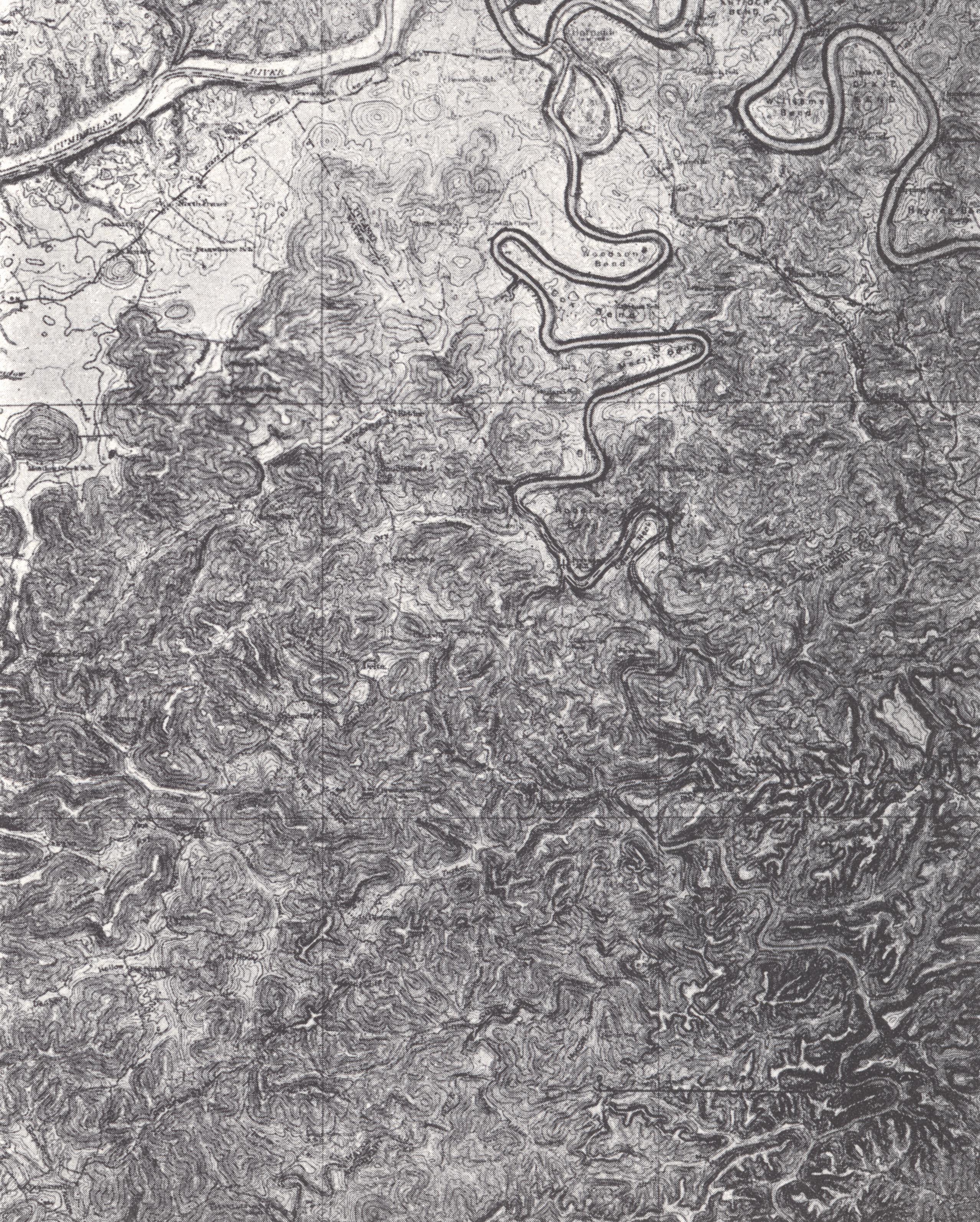
Within this section major streams have carved out extensive bottom lands, along which the rivers meander in broad loops. Along the Cumberland River Sauer (1927) has recognized a distinct region, the "Cumberland Enclave." Here the river has developed a great series of bottoms on the inside of its great loops 200 to 300 feet below the upland. The river is still degrading as indicated by frequent "riffles," and the bottoms lie 40 to 50 feet above normal water level. Cut-offs are frequent. Some loops are almost closed, such as Salt Lick Bend, Cumberland County, and Horse Shoe Bottom, Russell County. Soils are river alluvium, but include residual, and wash and creep from the valley sides. It is good farming country, with each loop more or less a community unto itself with intercommunication by river. There are about 20 of these big bottoms with the adjoining upland for several miles around so dissected as to be more or less untilled and uninhabited.
At least in the Cumberland River vicinity the summit level truncates the structure, preserving portions of the Highland Rim (Lexington) peneplain, which is separated from that of the Blue Grass region by the Muldraugh's Hill cuesta. Although this Cumberland River region has lost its cap of St. Louis limestone, with the exception of occasional, monadnocks, the loss was later and more localized than in the Blue Grass. The loss of the St. Louis is a matter of higher structural position than to the east and west, but at the same time considerably lower than in the Blue Grass. The divide between the Green River and Cumberland River drainage in southern Adair County has preserved a connecting link of St. Louis between the western and eastern Pennyroyal.
Mammoth Cave Plateau.—This is the upper cuesta behind the Dripping Springs Escarpment and extends to the margin of the Western Coal Field. The Pottsville Escarpment, there, is not the outstanding topographic feature that the Dripping Springs Escarpment and Muldraugh's Hill are. To the north in Meade and Breckinridge counties the introduction of the Sample (Bethel) sandstone in the section results in a double cuesta facing the Pennyroyal, the lower one the more conspicuous because of topographic contrast with that lowland. In its solution features this region is allied with the Pennyroyal rather than the Western Coal Field which it matches in ruggedness.
The Dripping Springs Escarpment rises 150 to 250 feet above the bordering Pennyroyal with the usual outlying remnants or knobs. The margin is deeply indented by deep cliff-bordered valleys, which, however, are marked by large sinks and dismembered drainage. The sinks, here, in contrast to those of the Pennyroyal are in the valley floors rather than the upland, and in them minor drainage lines terminate. It is in this rugged border belt in the vicinity of the Green River that the great cave region of Kentucky is developed. Back from this front the country is less rugged. When the Cypress is not too thick, small sinks with sandstone throats are developed. The Cypress sandstone cuesta marks the marginal area, but back from it the succession of other formations also express themselves in the topography. In the area to the east the outcropping Leitchfield formation gives a shale country adjoining the Pottsville cuesta. To the south of the coal field the Leitchfield is replaced by alternating sandstone and limestone formations. Some of the former are massive and cliff-forming. In the upper Leitchfield formation in Butler County a cliff-forming sandstone member may readily be mistaken for the Caseyville.
In Caldwell, Crittenden, and Livingston counties in the west the identity of the usual double cuesta characteristic of the Mississippian Plateaus is lost in the maze of normal faults. This is Sauer's (1927) Marion area. The faulting has produced a mosaic of fault blocks with abnormal and discontinuous outcrop and dip. Under the circumstances erosion has carved from these beds a topography in which there is little uniformity. The larger stream valleys show the alluvial fill typically developed in the Western Coal Field and Purchase. On the uplands bordering the Ohio River loess is present up to 40 feet thick. In Hart and Edmonson counties the region is crossed by the Brush Creek Hills (p. 187).
The Mississippian Plateaus were virtually unsettled in 1780 but developed rapidly after 1820. Ease of access from the Blue Grass and Nashville along with favorable topography in the Pennyroyal, accessibility to water, and an abundance of timber and grass led to its rapid growth. The agricultural situation is summarized by Sauer (1927, p. 207).
"The areas which produce a notable commercial surplus are the following: (1) the Pennyroyal Plain and dependent adjacent sections which specialize in tobacco, (2) the eastern Pennyroyal Plain which markets strawberries and livestock, (3) the counties near Louisville which market dairy products, tobacco, and pork, (4) the Ohio River counties in the west which have a surplus of cattle and pork, (5) the smooth land in the Greensburg Area, producing tobacco in small surplus, and (6) the Cumberland Valley-which sells pigs."
River transportation is afforded by the Ohio, Green, and Barren rivers (to Bowling Green). A small part of the Cumberland River below Burnside is also navigable.
 |
 |
 |
|
PLATE XLVI Burnside topographic sheet (± X ⅓).-Parts |
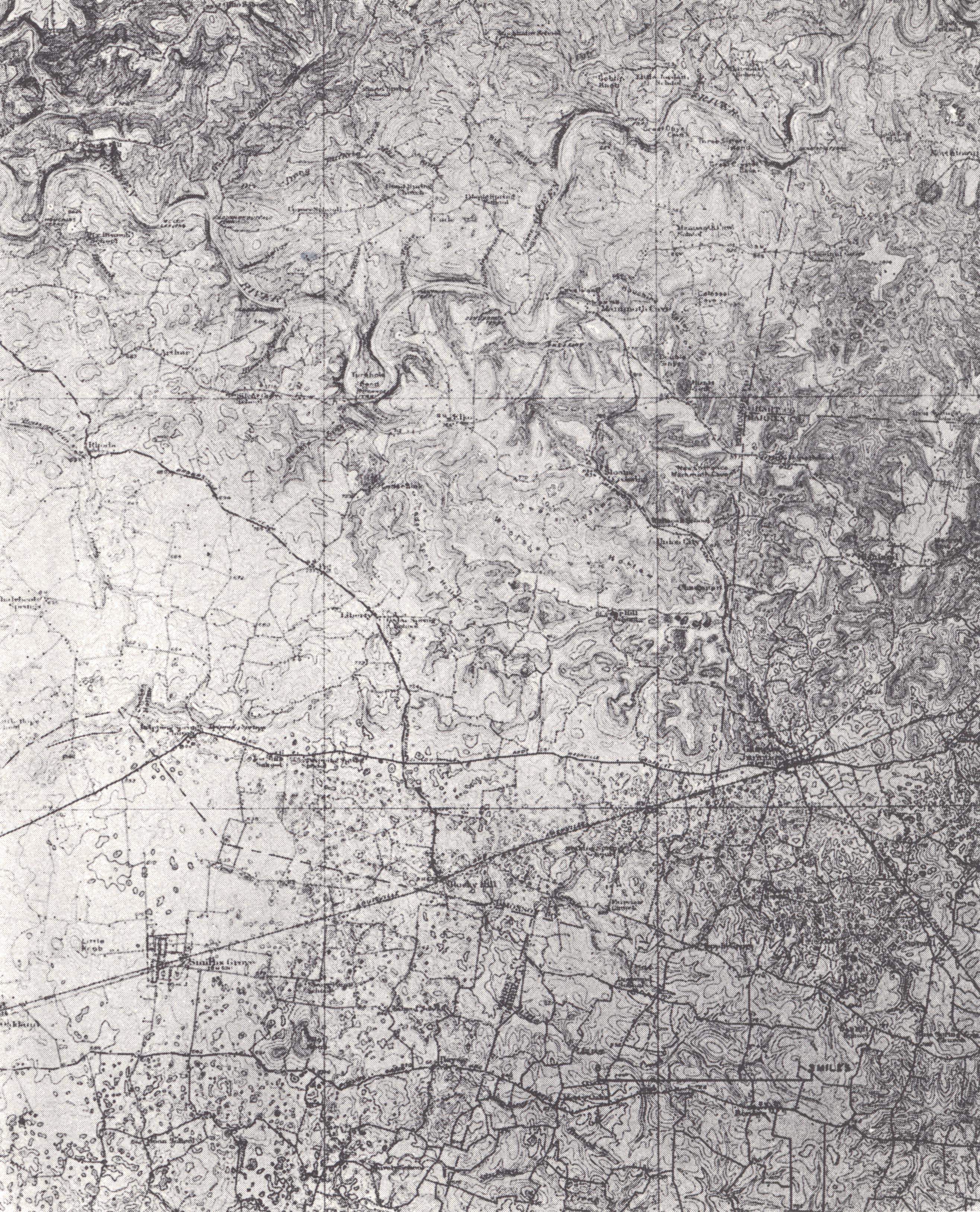
PLATE XLVII East half of the Topkinsville and west half |
PLATE XLVIII Mammoth Cave topographic sheet (± x ⅓) |