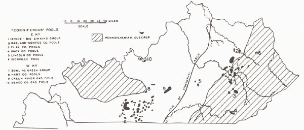
FIG. 30. Distribution of Corniferous oil and gas pools
Sections
A. Introduction
B. Pays
C. Corniferous production
D. Big Six gas field
E. Knox-Whitley counties pools
F. Wayne County field
G. Cumberland River field
H. Big Lime production of Owsley County
I. Production of the Paint Creek uplift
J. Gas fields of Floyd, Pike, Knott, and Martin counties
K. Boyd County gas field
L. Berea production of Lawrence County
M. Owensboro field
N. Miscellaneous small oil and gas pools of western Kentucky
O. Gas pools of Meade and Breckinridge counties
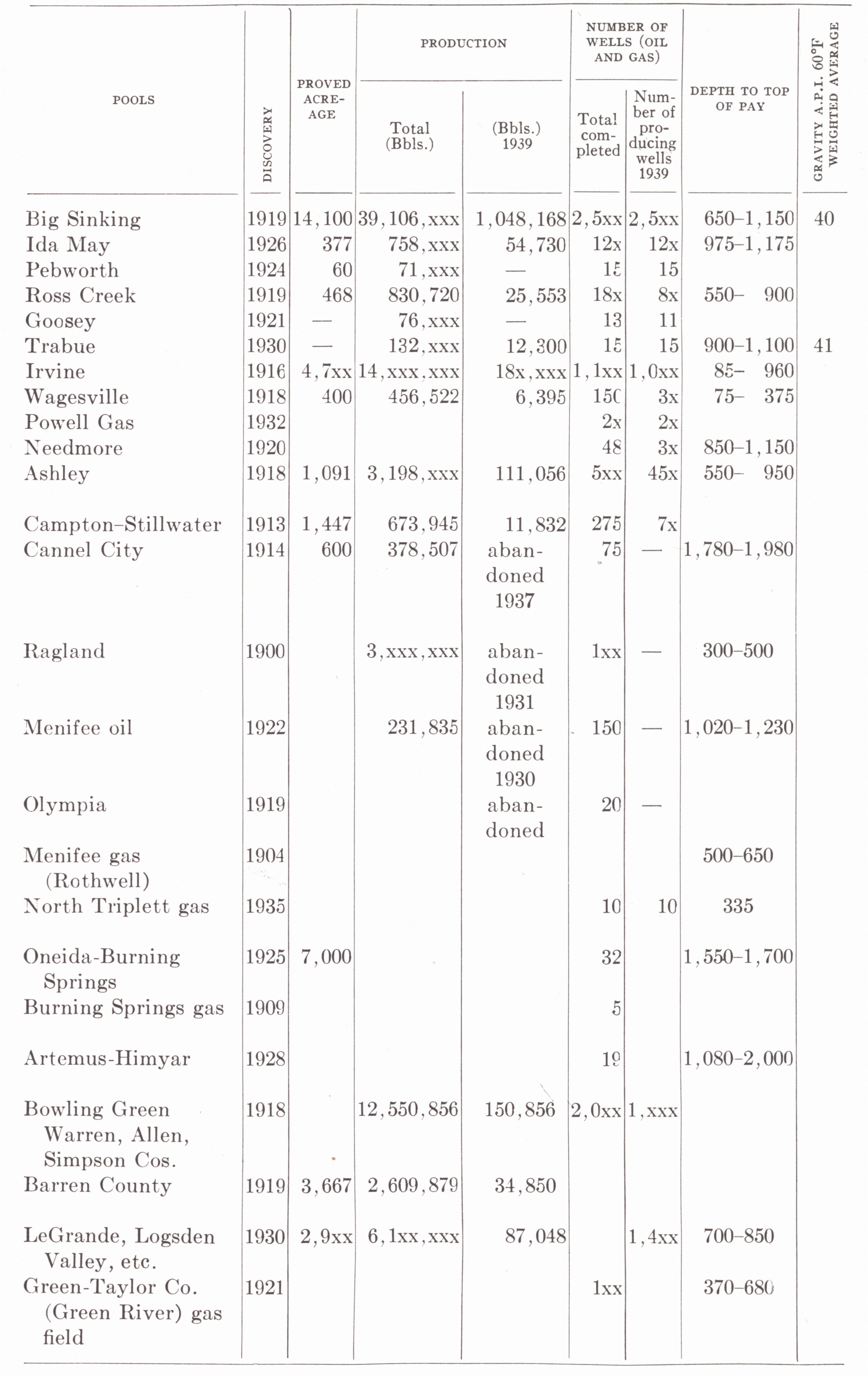
SECTION C—CORNIFEROUS PRODUCTION
CLASSIFICATION OF FIELDS
EASTERN KENTUCKY9
I. Associated with the isopach low (pre-Ohio upwarp) of Lee, Estill, Powell, and northern Owsley counties:
Big Sinking
Ashley
Irvine-Cow Creek-Fitchburg
Wagersville
Pebworth
Powell gas and Janet gas
Ross Creek
Owsley County gas = Turkey Knob = Needmore
Goosey
Trabue Heirs
Ida May
II. Associated with the Irvine-Paint Creek uplift (in part duplicating A, indicated by asterisk):
Irvine-Cow Creek-Fitchburg* Ashley*
Stillwater-Campton
Cannel City
III. Bath-Menifee County group:
Ragland oil pool
Rothwell (Menifee) gas
Menifee oil
Olympia
North Triplet gas
Janet gas (also listed under A)
IV. Clay County gas field
V. Knox County.
Himyar-Artemus.
WESTERN KENTUCKY
VI. Bowling Green group, including the pools of Warren, Allen, and Barren counties and unimportant production in Simpson and Logan counties:
Warren.—Belcher, Britt, Browning, Cox, Davenport, Gillispie, Lost River, Martin Bunch, Simmons, Moulder, Northeast Extension of Davenport, Piano, Rockfield, Sandidge, Sledge, White Stone Quarry, Woodburn, etc.
Allen.—Adolphus, Costello, Dalton, Gainesville, McReynolds, Meridith, North Petroleum, Petroleum, South Petroleum, Oliver, Rodemer, Scotts¬ville, Taylor School, Turlock (Miller), Wheat, Wildwood, etc.
Barren.-Beaver, Button, Cave City, Emery-Moore, Glasgow Center, Gorby, Hiseville, Lecta, Oil City, Sinking Creek, Somers, Steffy, etc.
VII. Green-Taylor counties:
Green River gas field
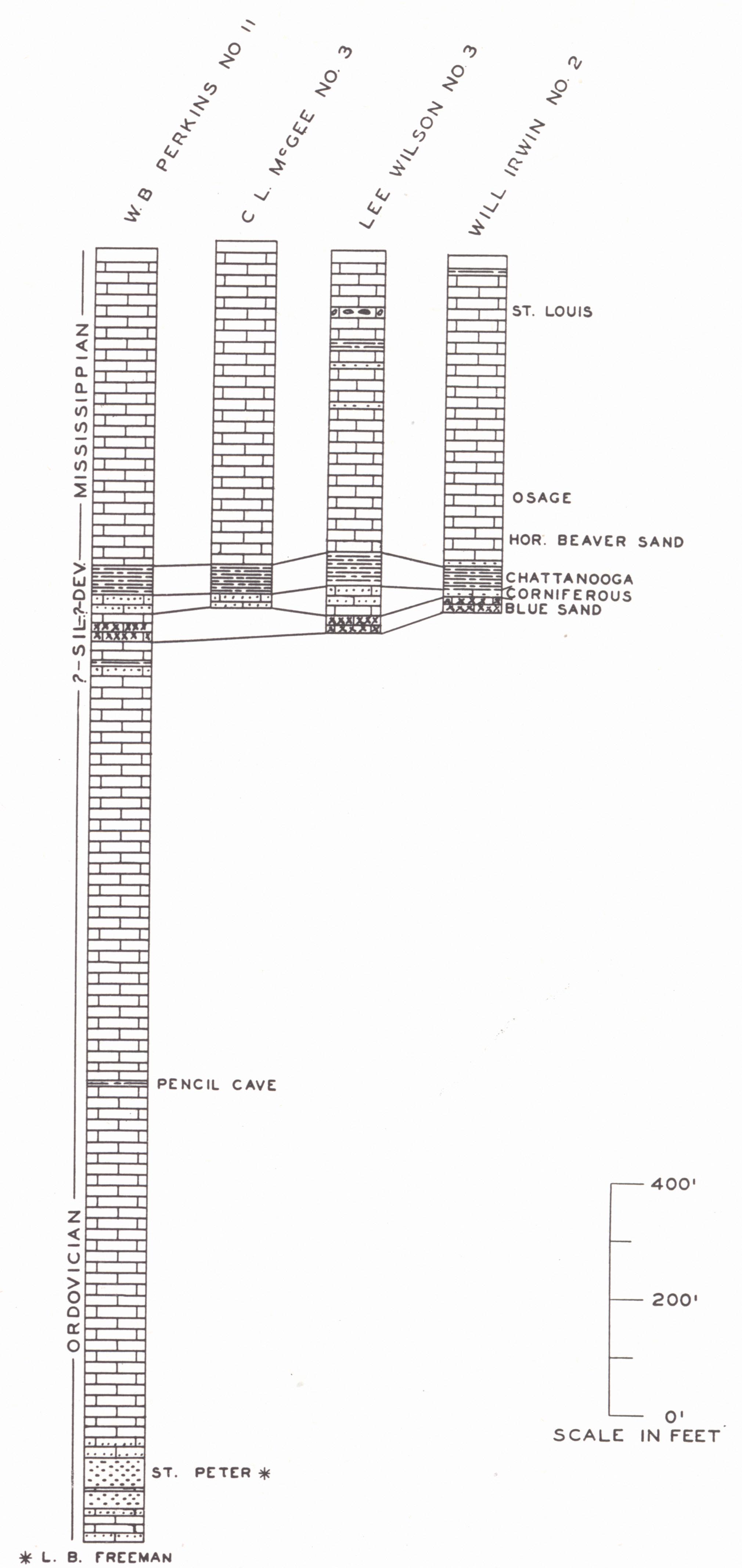
VIII. Hart County:
LeGrande
Logsdon Valley
Priceville
Magnolia
|
|
|
FIG. 30. Distribution of Corniferous oil and gas pools |
GROUP I
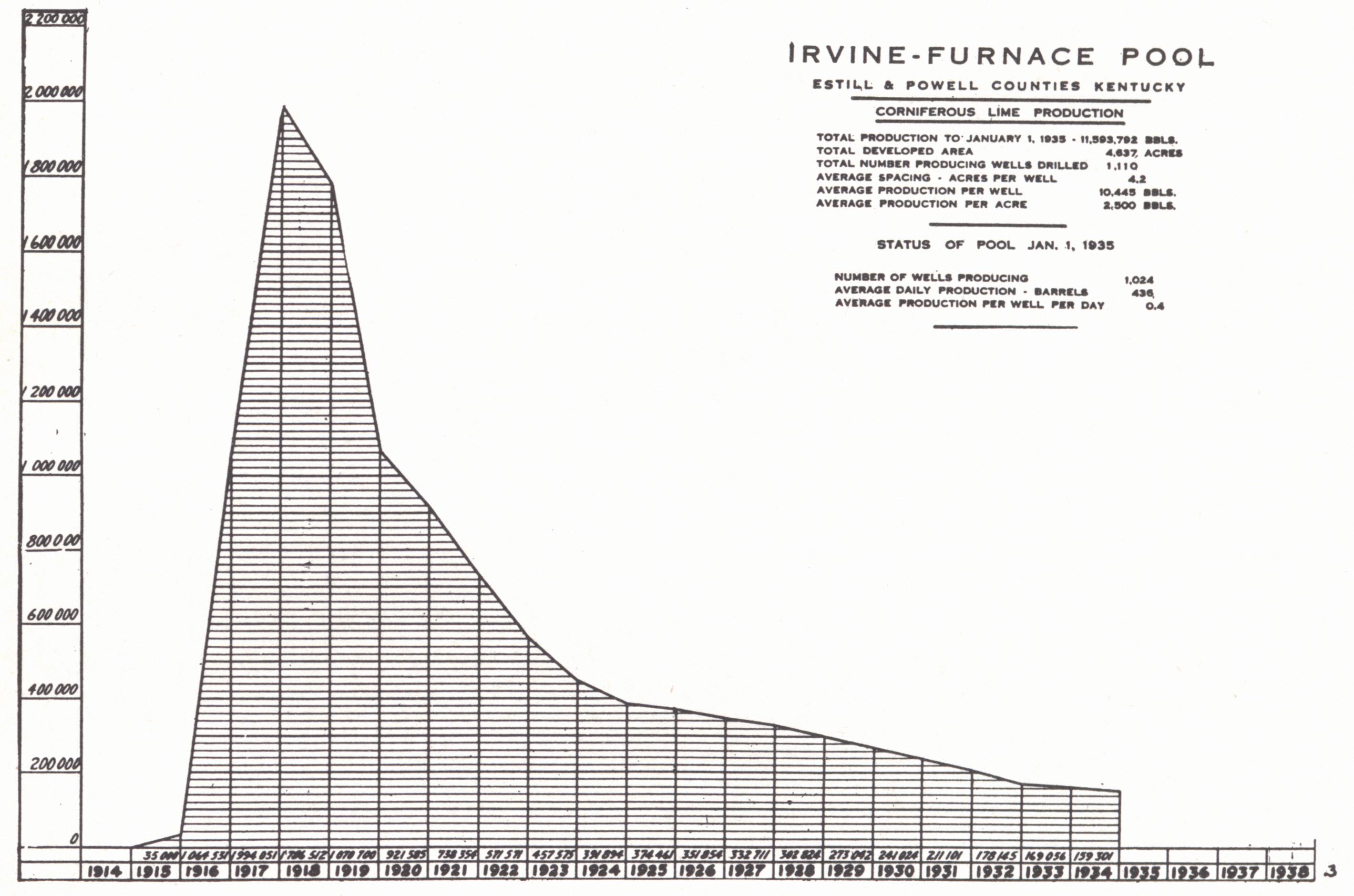
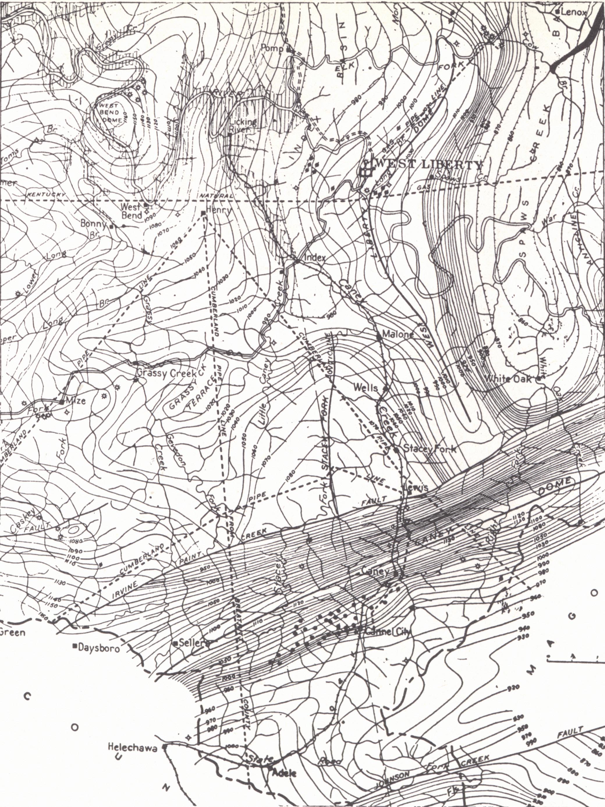
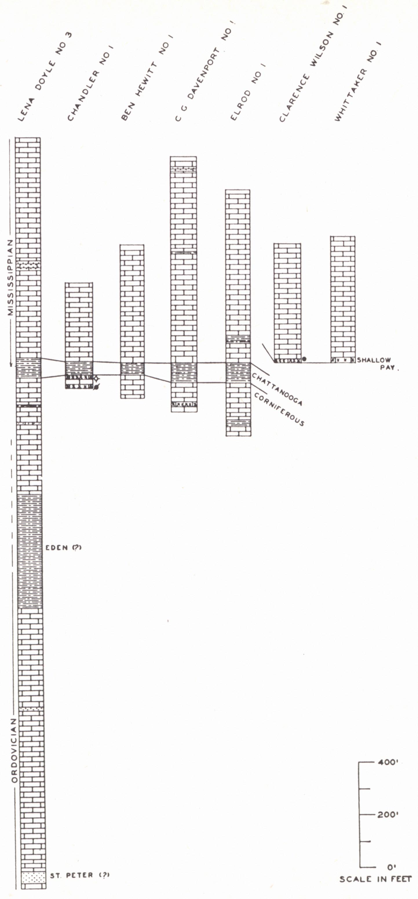
Fields of Lee, Estill, Powell Counties.-This field has been Kentucky's greatest (fig. 29, p. 301), and its discovery marked the beginning of Kentucky as a large producer. It includes the Big Sinking, Irvine, Ravenna, Ross Creek, Station Camp, Ida May, Ashley, and other pools.
Oil from wells drilled for brine in the Irvine region had been known since the middle of the nineteenth century. The Ravenna pool was the first commercial development and followed shortly the discovery of the Campton pool in 1903. Production was exceptionally shallow (75 to 110 feet) and very close to outcrop. The Irvine field, proper, dates from the finding of oil early in 1915 on the Dan Rollings farm on Tick Fork about 5 miles northeast of Irvine. Kentucky had developed in these early days something of a reputation of short-lived production and many dry holes. As a result the growth of the field was slow. In 1916, though, the boom was on. A number of successful wells had been drilled in the general region of the Big Sinking pool prior to the drilling in of the Eph Angel No. 1 by the Eastern Gulf Company in February 1918. This well opened up this prolific field. In the meantime the Ross Creek, Station Camp, and Ashley pools had been discovered.
Production is from the "Corniferous," the thickness of which increases toward the east (fig. 31). The number of pays has been reported as from one to three--the upper one of which has commonly been regarded as true Corniferous, the lower one or two as Niagaran. The eastward thickening of this limestone zone, intervening between the Black shale and the Crab Orchard below is mainly by the addition of Silurian and Helderberg formations beneath the Boyle (Hamilton). These formations thus overlap on the Crab Orchard shales below and are overlapped by the Black shale above.
Near or at the base of the Black shale a zone of light colored shale is recognized by drillers and called the "Fire Clay." Brown shale which in many places comes below they refer to as the "Coffee shale." The "Fire Clay" is regarded as probably Olentangy (Foerste, 1906).
The most significant feature other than the wedging of the limestone succession is shown in figure 31 (Jones and McFarlan, 1933). The pools form a broken circle around a large isopach depression, which was interpreted as outlining a truncated pre-Ohio anticline. The pools are thus arranged on the flanks of a fold which is not reflected in the post "Corniferous." The lack of continuity in the producing areas is a matter of varying porosity and perhaps in part minor structure. The former is well shown in the Boyle limestone in outcrop. Locally the normal cherty Casey limestone (upper Boyle) gives way to a much more porous crinoidal rock, and this is the case where the formation goes under cover in the Kentucky River at Irvine not more than a half mile from production (Ravenna). Later eastward tilt in the major movement completing the Cincinnati arch flattened and reversed the dip on the western and least productive flank.
More recent observations by Wilder (1936) have shown that the second pay of the Irvine pool is frequently a calcareous sandstone running up to 95 per cent SiO2. The other two, where present, are limestone. Porosity is largely a matter of the weathering of the dolomitic limestone, commonly the leaching out of fossils. Cores studied by the author (1938d) showed the entire productive section of the Irvine pool to be Silurian. Halysites occurs within 2 feet below the Ohio shale. The westernmost cores available were from wells located within 5 miles of outcrop of the "Corniferous" where the Boyle limestone only, intervenes between the Crab Orchard (Clinton) and the Black shale. The results of this study along with other observations indicate:
(a) All pays of most of the Irvine pool, and by inference many of the others, are Niagaran.
(b) The pre-Ohio anticline inferred from the isopach map was verified. The absence of the Mid-Devonian limestone is a matter of upwarp and truncation.
(c) The main pay is the Peebles dolomite and the lower, the Lilley dolomite. These formations are unknown in outcrop in Kentucky, except in the immediate vicinity of the Ohio River, but are known in outcrop over a wide area in Adams and Highland counties of southern Ohio. The No. 2 sandstone pay is apparently a sandstone phase of the Peebles.
(d) The Ohio-"Corniferous" contact is an irregular one and the significance of the terms No. 1, No. 2, and No. 3 pays is one only of order of succession below the shale. The complexity of the several contacts involved is suggested by figure 32.
The extent to which the Mid-Devonian limestone reappears in the sub-surface section on the flanks of the buried anticline is not well established. It is present in a part of the Irvine pool (15 feet of a 60-foot "Corniferous" section) but has not been observed in any of the wells so far studied in the Big Sinking pool nor in the occasional wells available on east to eastern Morgan County (Freeman, 1941a).
Freeman (ibid.) emphasized the role of the structure and resulting un-conformity in determining the distribution of porosity, thus an indirect rather than direct structural control.
In the case of the Irvine Pool the situation is modified by the anticlinal uplift along the Irvine-Paint Creek fault. This structure was thus super¬imposed on the earlier one, and constitutes a modifying factor. The field is a shallow one of 200 to 800 feet. The shallower wells in the lowland to the west began in the Waverly; the deeper ones, near the base of the Pottsville. Two deep tests to the St. Peter were drilled on White Oak Creek north of the fault zone. One gave a strong show of gas. More recently, a third deep test near Bear Track showed gas at several levels including the St. Peter.
The Big Sinking lies on the eastern flank of the buried structure where later tilting of the Arch accentuated the dip to the east. Three pays are commonly recognized. None are consistently present but the general distribution is in harmony with the picture of a progressive overlap and truncation of the limestone succession (Jones and McFarlan, 1933). The distribution of salt water is also in conformity with this concept. Some wells flowed when drilled in, and in some cases continued to do so for a few weeks. The better ones showed 200 to 300 barrels flush. Few wells produced gas only, and little effort was made to conserve it.
| PLATE LXXXVII | |
 |
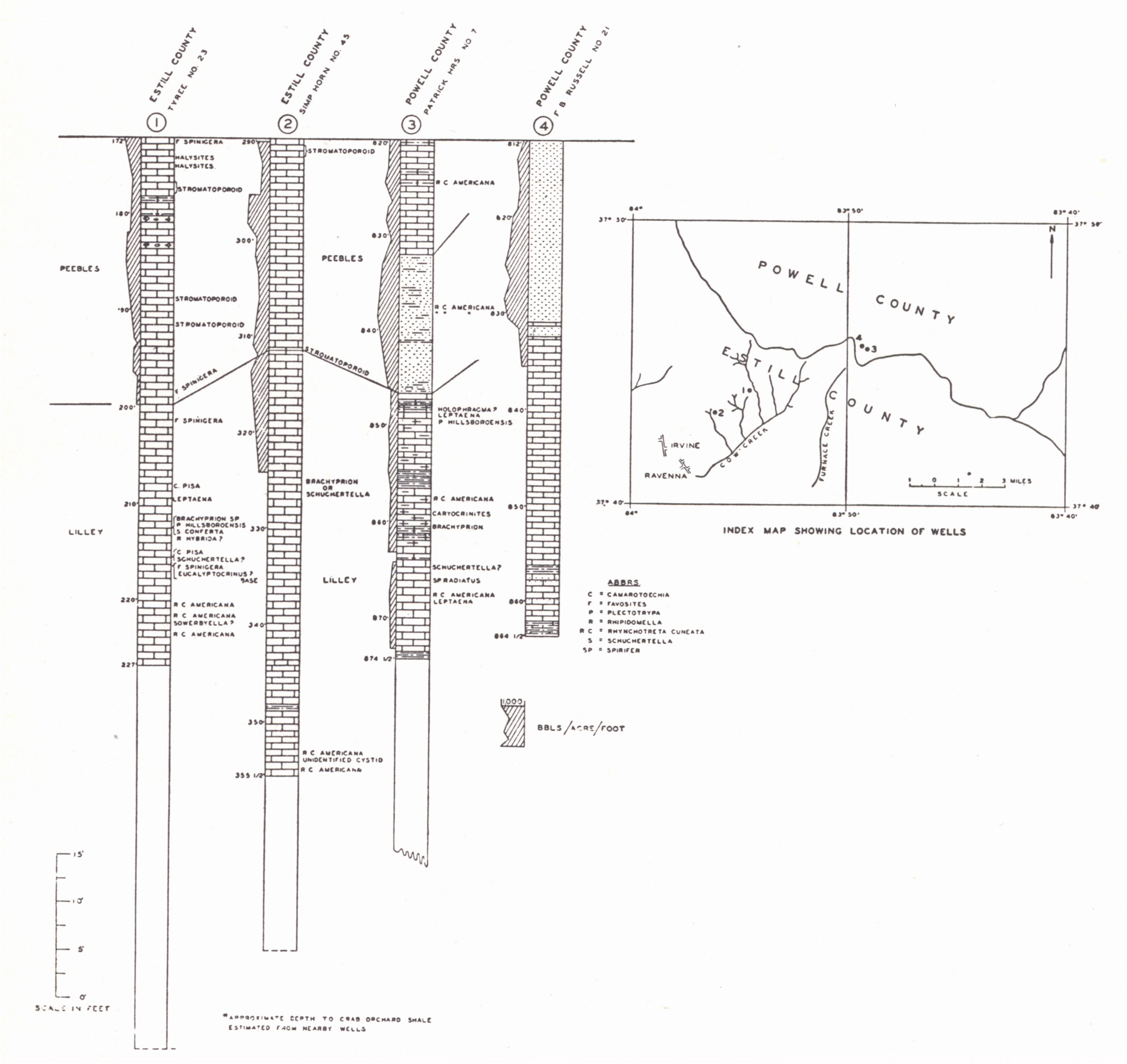 |
| FIG. 1. Sections of the Corniferous, Big Sinking pool, Lee County (Jones and McFarlan, 1933). Pay indicated in black. | FIG. 2. Correlation of drill
cores from Irvine pool in Estill and Powell counties (McFarlan, 1938d) |
Ravenna Oil Mine.—About 1920 an experimental shaft 8' x 12' and 130 feet deep was cut through Ohio shale to the underlying "Corniferous" at Ravenna, Estill County. It was planned to drill a tunnel 6 feet high and 7 feet wide up the dip. The plan involved the recovery of oil draining down the shaft and retorting of the oil sand, which, it was claimed, carried up to 25 per cent oil by volume. Up until 1921 recovery had been 2 to 3 barrels per day. The plan was later abandoned. (Jillson, 1921i.)
| PLATE LXXXVIII |
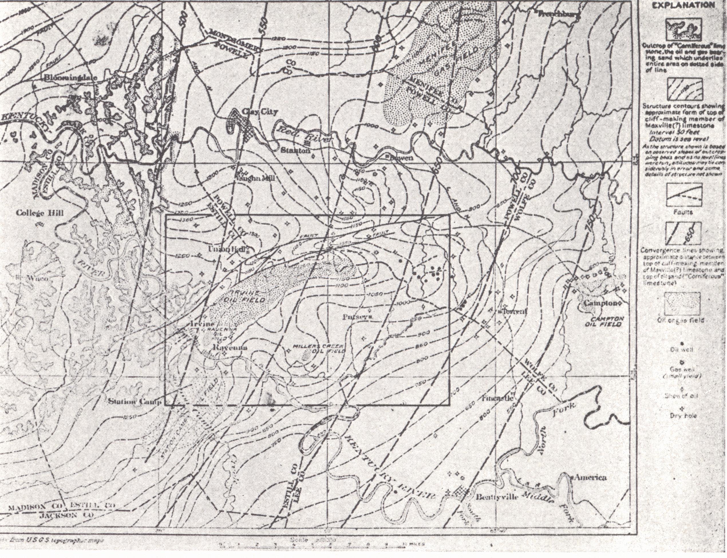 |
| FIG. 1. Sketch map of
geologic structure of Irvine oil pool and vicinity, Estill, Wolfe, Powell, and Menifee counties. Structure contoured on top of Big Lime (St. Louis, Ste. Genevieve, and Lower Chester). Convergence (heavy broken lines) on interval between this same datum and the top of the "Corniferous" (Shaw, 1917). |
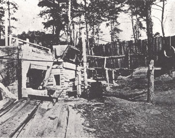 |
| FIG. 2. The Kinney "oil mine"
shaft (Jillson, 1921i). An attempt was made to recover petroleum from the Corniferous near outcrop by sinking a shaft and cutting a drift along the pay. |
Owsley County Gas Field (Turkey Knob gas field of Jillson; Needmore pool of Hunter).—This pool in northern Owsley County discovered in 1917 lies just south of the Ida May pool and consists of about 50 producing wells. The larger commercial wells produce from one to three million cubic feet open flow with a rock pressure of 300 pounds. Jillson (1937) listed a total open flow of 16 M for 1930. Production is from the Corniferous at 1250 to 1400 feet. In the absence of a major fold (surface structure) Fiske (1929) interpreted production to be controlled by favorable conditions of porosity. However, along with the Ida May pool, it seems to be a part of the Lee-Estill-Powell county group centering around the isopach low. Production in most cases apparently comes from immediately beneath the Chattanooga shale, either with or without cap rock. The "fire clay" (Olentangy) is rather consistently present.
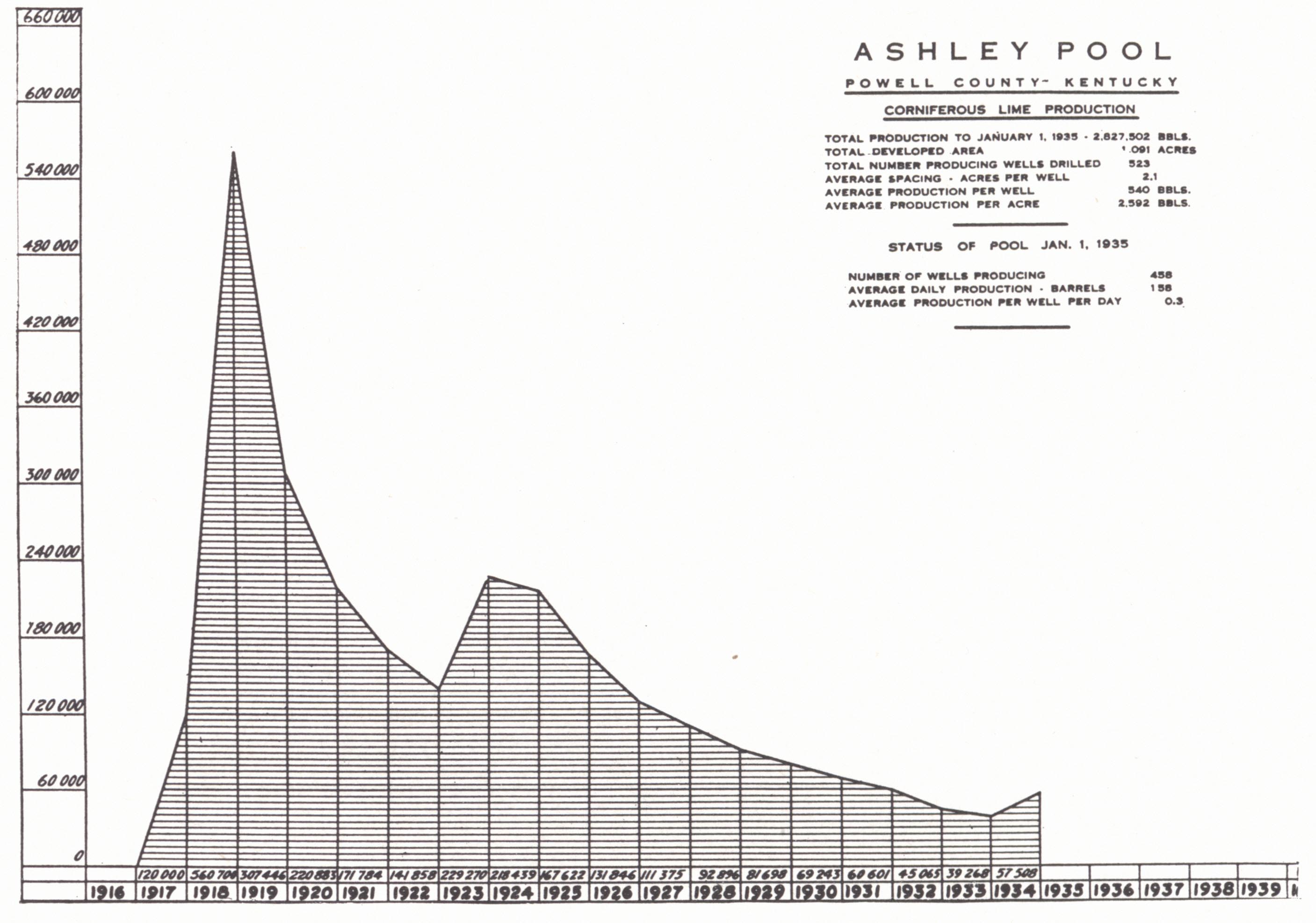
Ida May Pool.—The Ida May pool in southern Lee County, which was discovered by the Indian Tex Petroleum Company in 1923, reached its peak of production in 1924. The Corniferous occurs at about 1,250 feet. It is a member of this same group.
GROUP II
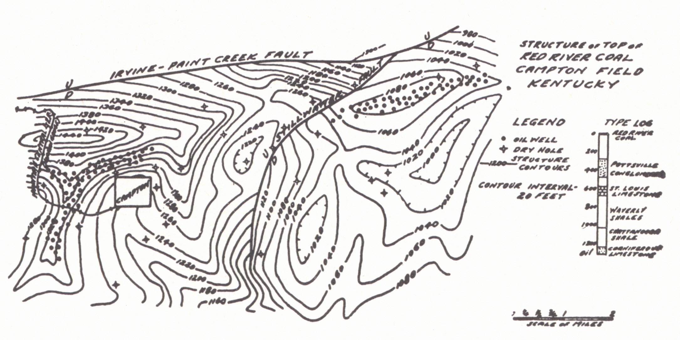
Campton Oil Pool.—The Campton pool (Wolfe County) was discovered in 1903 with the drilling in of the J. S. Cable No. 1 by the Beckett and Iseman Oil and Gas Company, and produced 100 barrels per day flush at 1,220 feet. The average yield of other early wells was around 50 barrels flush. About 275 wells were drilled and 80 per cent of them were commercial producers. The pool is located on the Irvine-Paint Creek structure.
Munn (1912) found little information available as to the nature of the pay, for the records indicated anything from creviced limestone to sandy limestone and calcareous sandstone. The situation is probably similar to that in the Irvine-Big Sinking where both limestone and sandstone produce. In the central and southern parts of the field only one pay is usually found 1 to 14 feet below the shale. In the northeastern part there are two, the second about 25 feet below the first, and each from 3 to 10 feet thick. Salt water is present. The Corniferous has a thickness of 140 feet or more. The Fire clay (Olentangy) is again present.
The structural control (Fiske, 1927) is an east-west closed structure west of Campton with a plunging anticline going off to the south. It is this southern area that is productive. After a barren strip, a closed structure east of the fault is also productive. Munn (1912) figured the structure west of Campton, contoured on the sand, as a southward plunging anticline, but the structure is not carried far enough to the north to show whether the closure is also present at this depth. Fiske (1927) concluded that local character of the Corniferous constituted the principal control. The two pays come high in the sub-Ohio limestone succession.
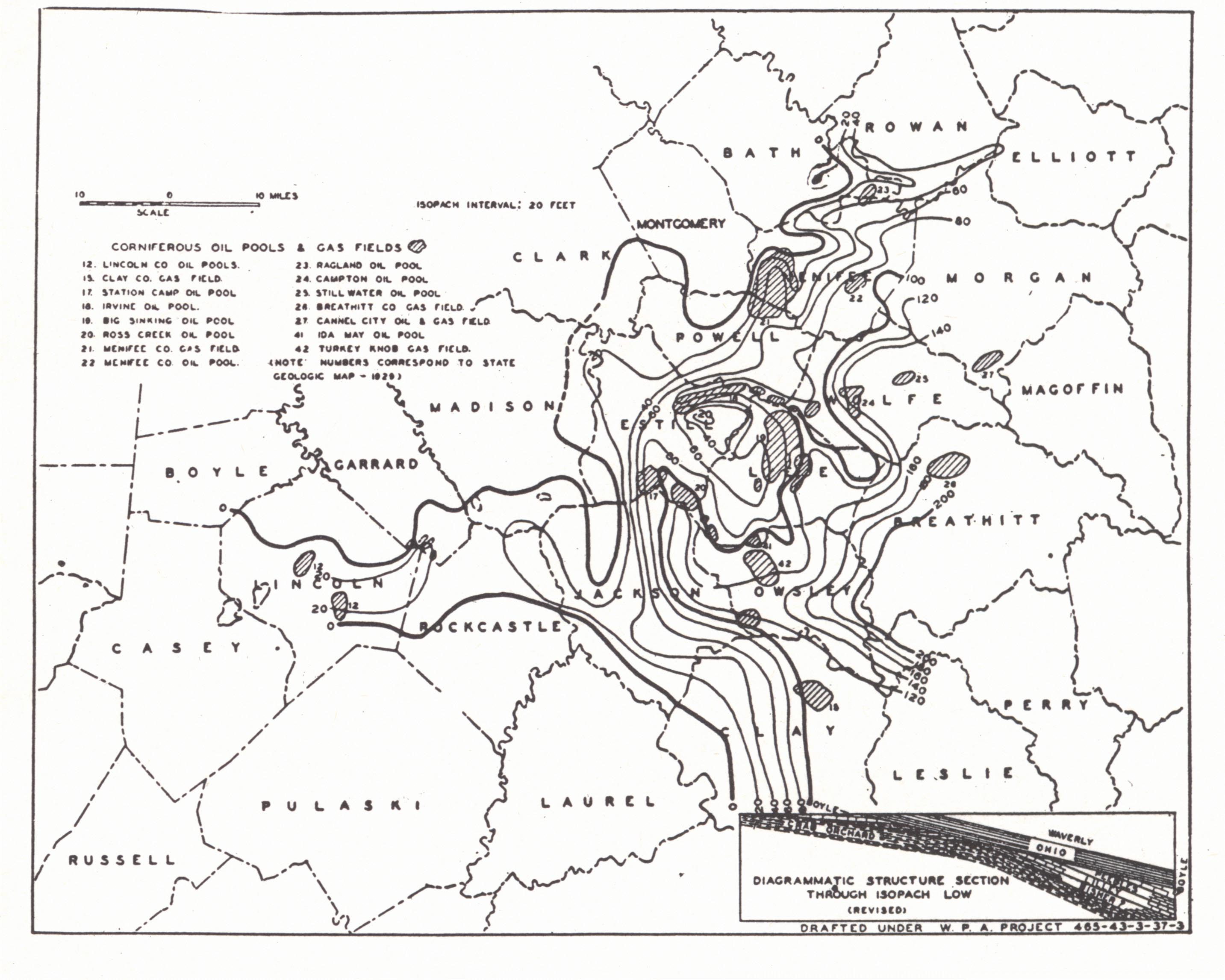 |
| FIG. 31. Isopach map on the "Corniferous" in
eastern Kentucky (Jones and McFarlan, 1933-diagrammatic section revised, McFarlan, 1938d) |
Morgan County.—Some oil and gas production from the Corniferous occurs in Morgan County, chiefly in the Cannel City area. Gas has also been found at Mize Post Office in the southwestern part and Elk Fork in the northern part.
The Cannel City oil pool occupies the southern flank of the Caney anticline, which parallels and lies south of the Paint Creek fault. The first successful well was drilled at Cannel City in 1912 and came in flowing. It yielded 320 barrels per day. According to Miller (1919) 58 wells were drilled. Two were gas wells. Depths varied from 1,500 to 1,800 feet plus. According to the same author, the average interval between the pay and the Cannel City cannel coal is 1,612 feet; the interval to the Fire Clay coal, 1,726 feet.
Structural relationships are shown in the accompanying figure (plate XC, fig 1). It is another of the pools developed along the Irvine-Paint Creek structure.
The Elk Fork gas field is a small Corniferous gas field northeast of West Liberty and 8 miles north of the Paint Creek fault. It consists of a half dozen wells producing not more than one-half million cubic feet each (Jillson, 1922) and was developed at about the same time as the Cannel City pool. The gas is marketed in West Liberty.
The occurrence is shown rather low at the north end of the West Liberty dome with sharp dip to the east and northeast. Structure contouring was done on the Fire Clay coal.
| Plate LXXXIX | |||
 |
 |
 |
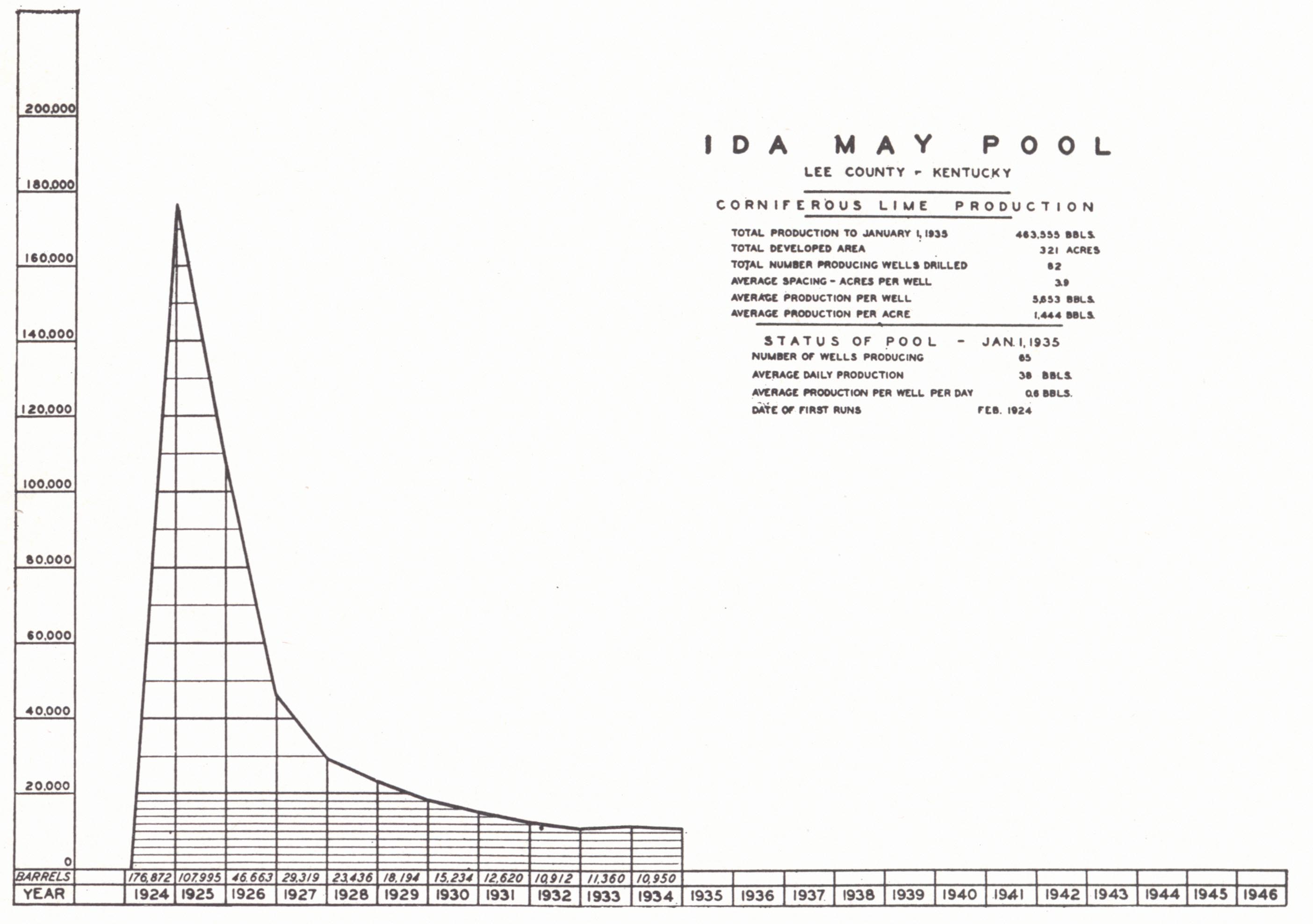 |
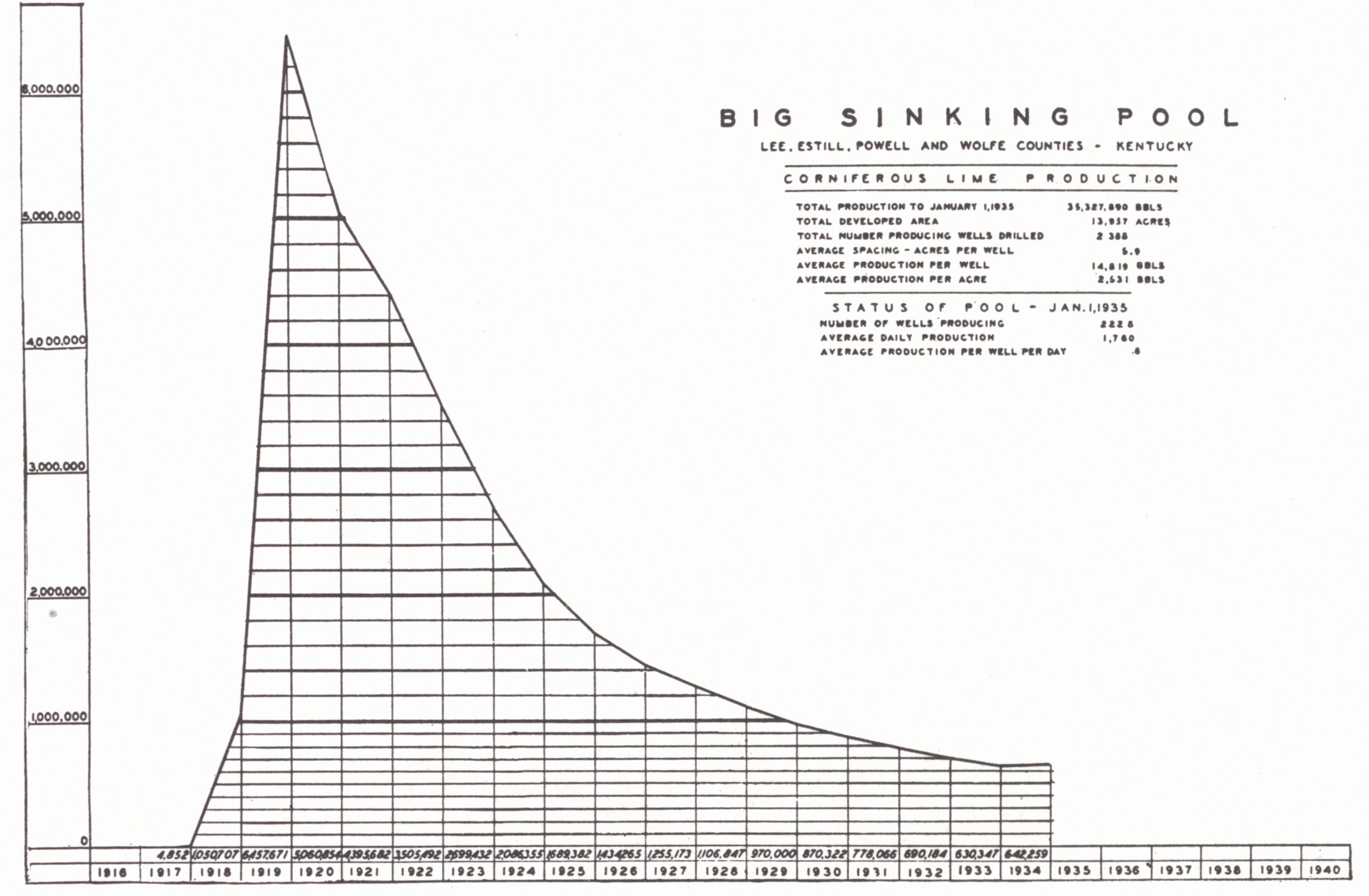
| FIG. 1. Big Sinking pool, 1918-1934 | FIG. 2 Ashley pool, 1917-1935 | FIG. 3. Irvine-Furnace pool, 1916-1934 | FIG. 4. Ida May pool, 1924-1934 |
The Grassy Creek (Mize) gas field was opened with the drilling of a few gas wells near Mize Post Office in the southwestern part of the county in 1917 and 1918. The largest is reported to have yielded 1 M flush (Jillson, 1922c). Development of the field was continued again in 1921 and in 1938 there were 24 producing wells. The Corniferous occurs at 1,300 to 1,545 feet. Maximum open flow is listed as 0.6 M (Jillson, 1937) and rock pres-sure 430 pounds.
 |
| FIG. 32. Diagrammatic cross-section in Ohio
showing the relations of the sheet type A-A' and the cavity-filling type B-B' of Hillsboro sandstone to the Niagaran and Greenfield dolomites at the time of deposition of the sandstone. The present surface is shown by the heavy broken line. This figure is given here, as the stratigraphic relationships in the pay zone of the Irvine and associated pools probably show similar features (Carman and Schillhahn, 1930). |
The field lies several miles north of the Paint Creek fault and surface structure on the Fire Clay coal shows a small dome with only a ten-foot closure. It is unlikely that this is significant.
GROUP III
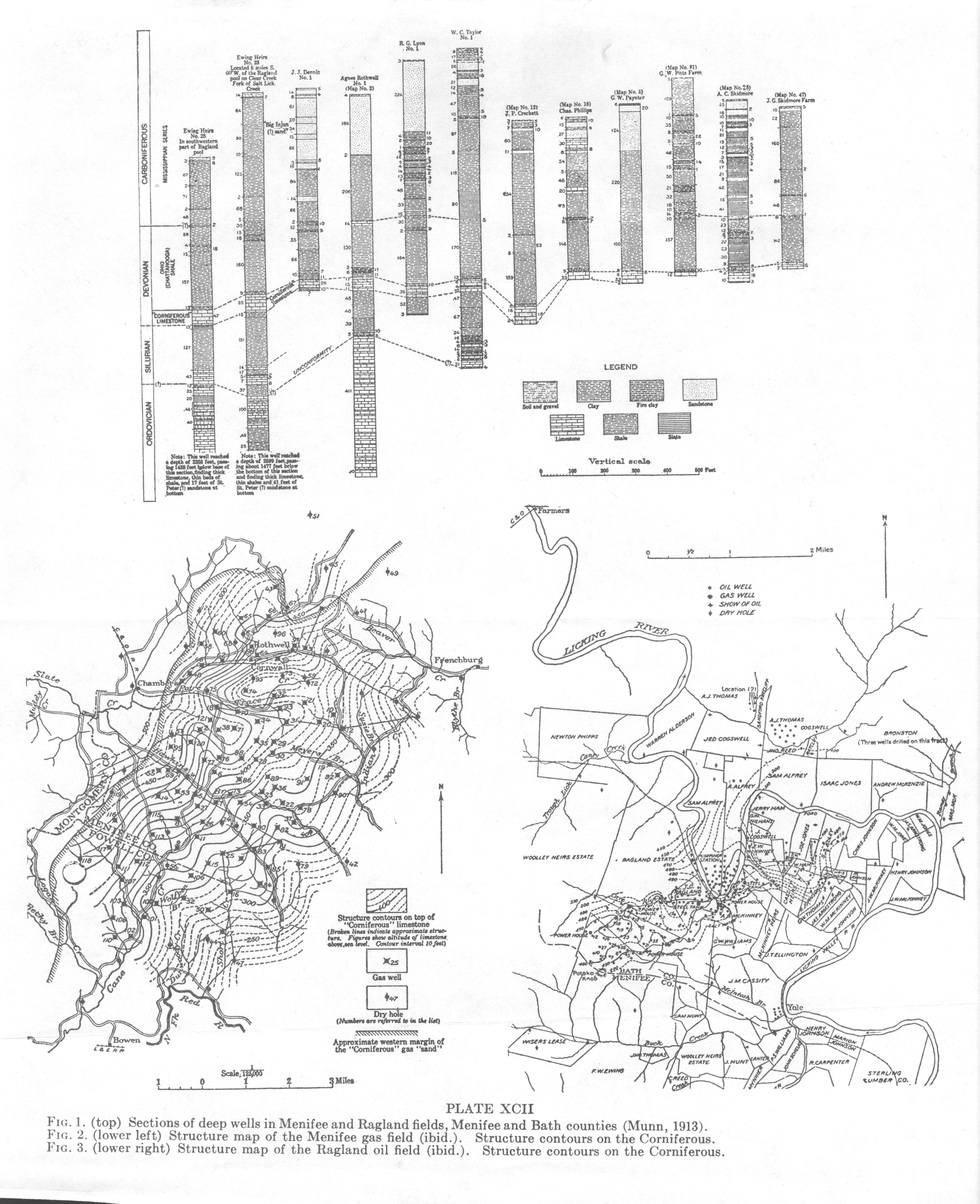
Ragland Oil Pool.—The discovery well of the Ragland pool on the Wooley Heirs (Munn, 1913)10 was drilled in 1900 with 30 barrels initial at a depth of 381 to 395 feet. Between 1900 and 1904 about 200 wells were drilled, of which 70 per cent were producers. Depths ranged from 300 feet plus in the valley of the Licking River to about 800 feet in the hills. The usual well showed 1 to 30 barrels flush, and exceptional wells up to 200 and 240 barrels. Some gas was present and was used for pumping. Wells in the bottoms began in the Waverly, those on the hills in the Ste. Genevieve or Chester. Most of the production was piped to Salt. Lick and shipped out in tank cars. For a time there was connection with the Cumberland pipe line to the southeast. The oil was a heavy, black oil commonly referred to as asphalt oil and was sold at a low price. It was used as fuel and as road oil. It was, however, an intermediate base oil, similar to other "Corniferous" oils, which had lost its more volatile constituents due to nearness of the reservoir to outcrop.
| PLATE XC | |
 |
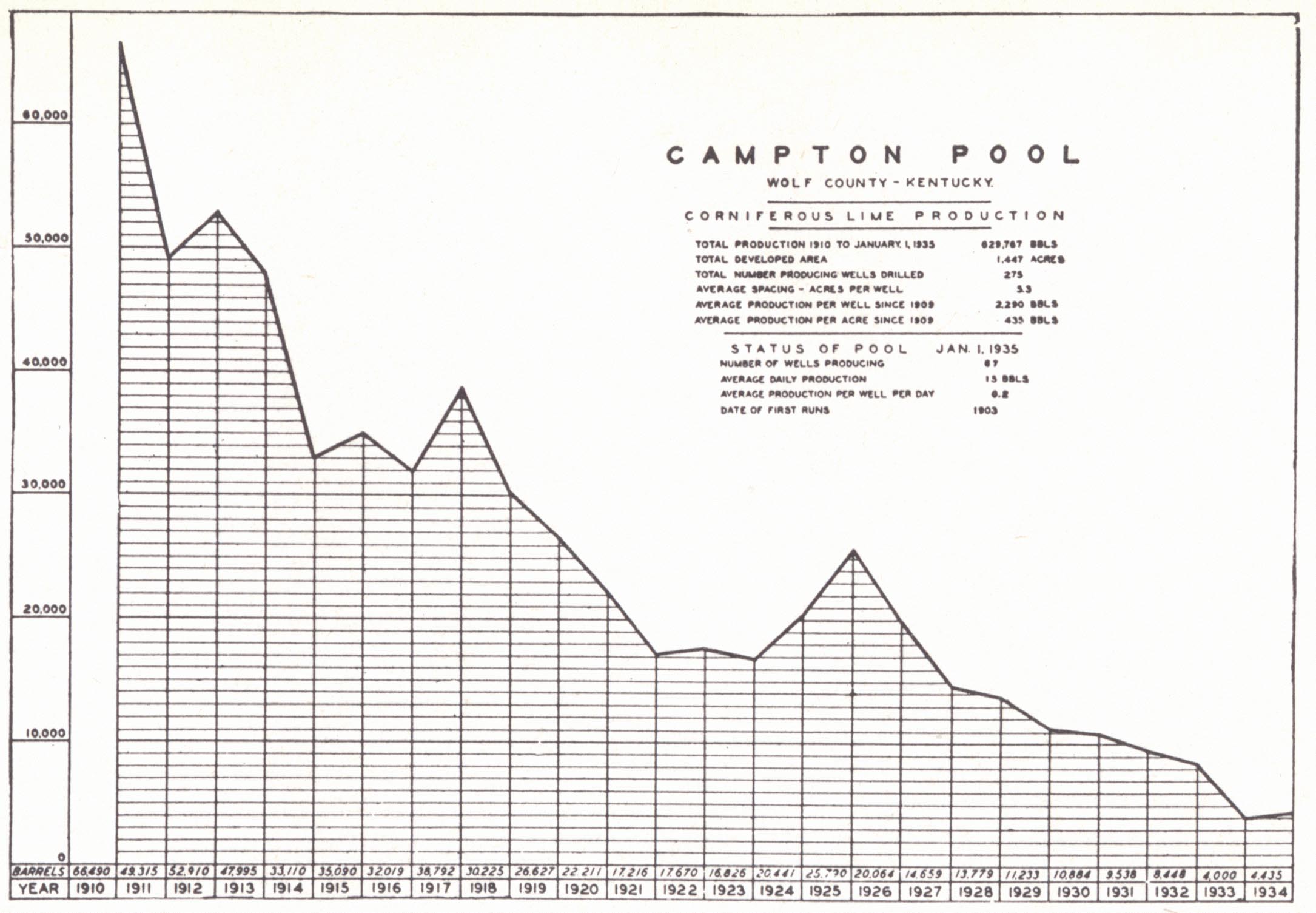 |
| FIG. 2. Production chart of
Campton pool. 1911-1934 (Kentucky Oil and Gas Association, 1935). |
|
 |
|
| FIG. 1. Structure map of a
portion of Morgan County, showing the Caney dome, Irvine-Paint Creek fault and minor structures (Robinson and Hudnall, 1925). |
FIG. 3. Structure map of Campton Pool (Fiske, 1927). |
Production is from the Corniferous, which is overlain by the "Coffee shale" and "Fire Clay"11 or the latter alone. Below is the Crab Orchard shale. The limestone runs between 20 and 30 feet thick, with the pay at varying levels within it.
| Plate XCI |
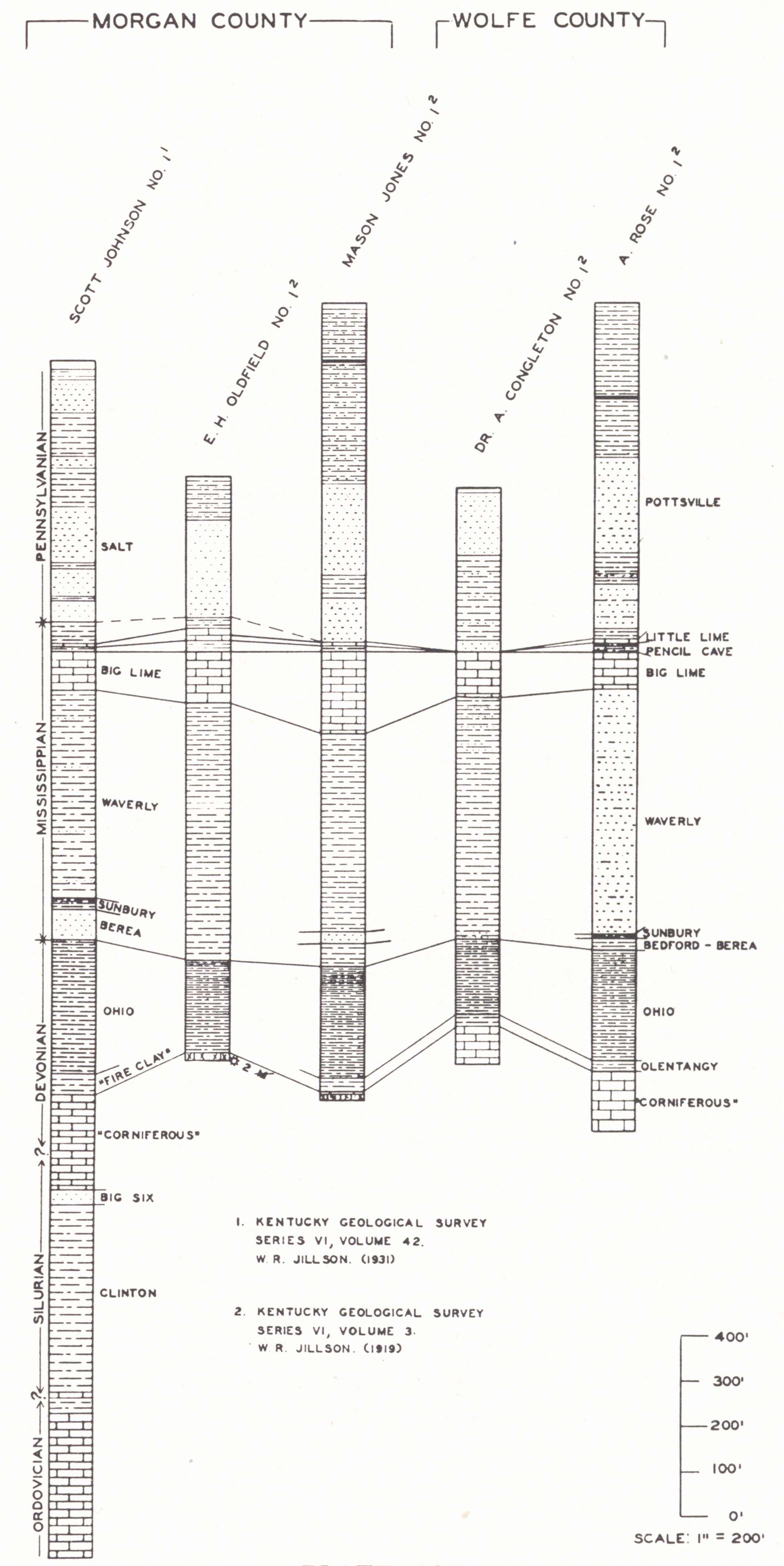 |
| Well sections in Morgan and Wolfe counties |
Several structural features may have controlled accumulation.
Production is located on the southeast flank of a monocline which constitutes the northeast extension of the Kentucky River fault structure. This is shown in both surface and subsurface work, and was regarded by Miller (1919) as the controlling factor. Subsurface structure drawn on the top of the Black shale in the western part of the field shows production concentrated on a nose on this monocline. This structure varies considerably from that drawn on the base of the St. Louis (base of Big Lime).
The isopach map (fig. 31) on the Corniferous shows an east-west low with production on the southern flank. An analogy is drawn with conditions found in the Irvine-Big Sinking field, i.e. a pre-Ohio fold. The superimposing of the later structure (monocline mentioned above) on this earlier one is probably the significant feature.
The field has been a long-lived one and after producing some 30 years was recently abandoned. For a number of years production had been limited to one or one and a half barrels per well.
Menifee Gas Field.—The Menifee gas field was discovered in 1904 as a result of the drilling of the E. J. Mynhier No. 1 by the New Domain Oil and Gas Company four miles southwest of Rothwell, Menifee County. It had an initial of almost 0.5 M, and rock pressure 75 pounds (closed) at 452 to 478 feet. An earlier productive well was that drilled in 1901 by Northcutt on Adams Branch (Miller, 1919). Wells began in the Waverly and yielded up to one million cubic feet. Only small shows of oil were found. In 1911 there were 90 gassers with an average rock pressure of 75 pounds. The gas was piped to Lexington and other central Kentucky cities by the Central Kentucky Natural Gas Company (10-inch line in 1906). A maxi-mum production of 25 M was reached June 1, 1942. By 1914 production had failed to the point that it was necessary to bring in gas from the Warfield-Kermit-Tug Fork field of West Virginia and Kentucky, local gas being used only for emergency. In 1920 rock pressure was down to 25 pounds, and the field was abandoned and has subsequently been used as a gas reservoir.
| Plate XCII |
 |
| Menifee and Ragland fields |
Production is from the Corniferous which is overlain by the "Fire clay" at the base of the Black shale. As in the Ragland pool the pay occurs somewhat erratically both vertically and horizontally within the limestone. Salt water occurs in the lower part of the pay and down the dip. The Corniferous is known to be absent at a number of places on the northern and western sides of the field and seldom attains a thickness of more than 40 feet.
Structure drawn on the top of the pay shows a monocline on which noses seem to have little significance. As pointed out elsewhere, this contact is an unconformable one, and minor "structures" indicated are likely ir-regularities of the old erosion surface. It is another of the "trend" pools.
Significant features include: (a) The rapid wedging to the northwest of the Corniferous. (b) The field occupies a small, local, isopach high bordered on the north, east, and west by minor depressions. An inferred structural low would not fit. Perhaps the preservation of a patch of Peebles or Lilley (pays of the Irvine field) protected by structurally low position from pre-Ohio erosion may be the answer, (c) The monoclinal flexure is like that of the Ragland field in that it represents the dying out of the Levee fault of Montgomery County.
Janet Gas Field.—The Janet gas field lies north of the Irvine-Paint Creek fault in south-central Powell County intermediate in position between the Irvine oil pool and the Menifee gas field. The first well was drilled in 1929. Twenty-one wells produced a total open flow of 8 M feet in 1935 from a depth of about 550 feet. Initial rock pressure was about 75 pounds (Jillson, 1937). The better wells were good for about 0.5 M open flow and one was reported good for 1 M. The gas is sulphur-free and is used in Stanton and for pumping oil wells in Estill County.
Geological features were described by Russell (1934b). Production is Corniferous. At the base of the Black shale is the "Fire Clay." The accumulation is interpreted by Russell (1934b) as independent of structure (determined on the base of the Big Lime) and dependent on the occurrence of porosity. At the same time he called attention to a thickness of 5 to 40 feet of Corniferous north of the fault (reported absent in a few wells) in contrast to about 100 feet on the south or downthrow side. The displacement is 180 to 200 feet, and the contrasting thickness of the Corniferous" on opposite sides may well mean pre-Chattanooga displacement and folding. Salt water was not found except in one or two wells on the east side of the field.
North Triplett Gas Field.—This is a small, shallow, "Corniferous" gas field 3 to 5 miles northwest of Morehead. The discovery well was drilled June 12, 1934, and in 1934 and 1935 eight producing wells were drilled to depths of 250 to 350 feet. Maximum open flow was 0.4 M; rock pressure was 45 pounds. The play was made on the "Corniferous," as it feathered out up the dip.
GROUP IV
| PLATE XCIII | |
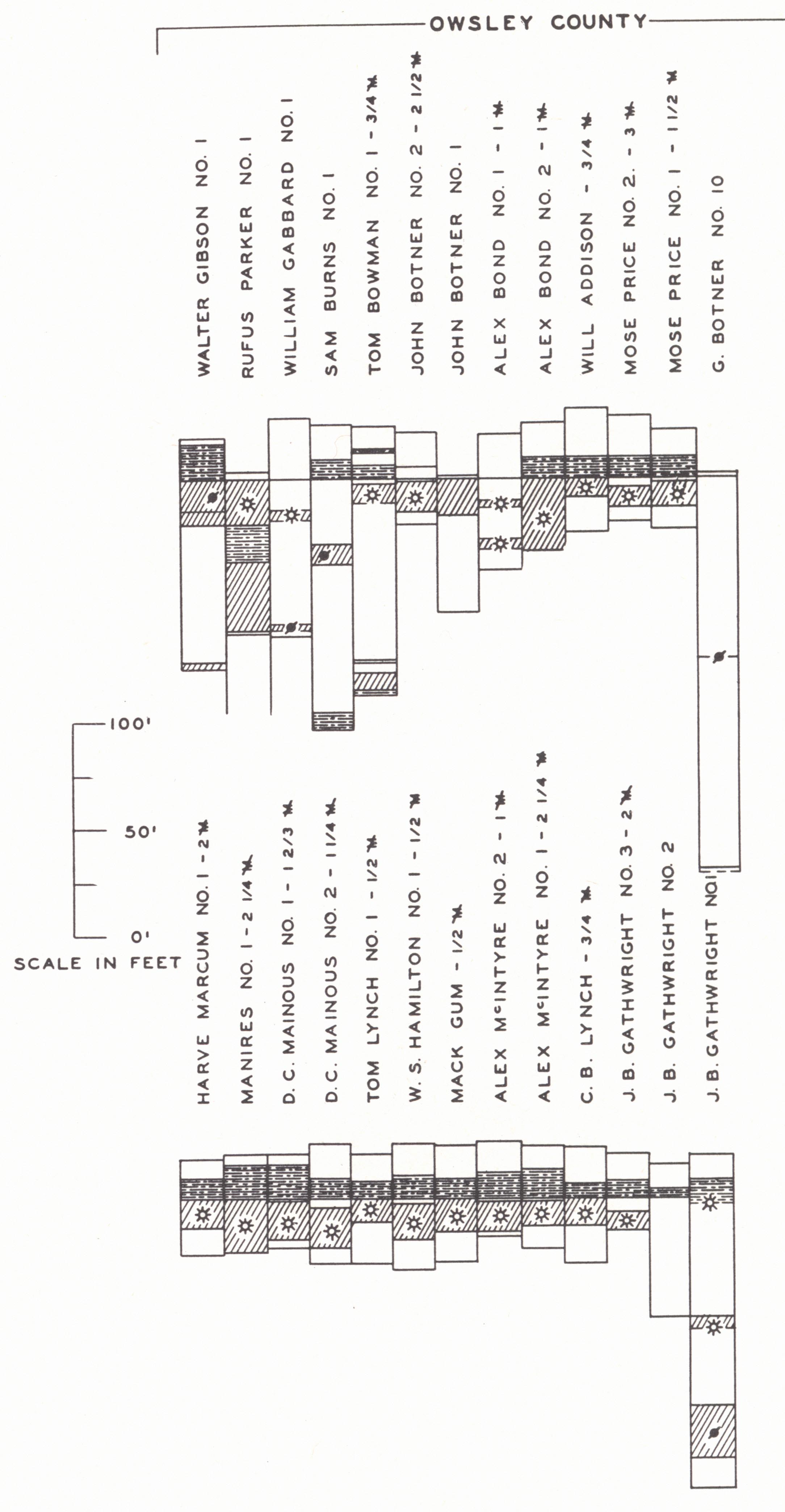 |
 |
| Sections of the pay in Owsley County |
Well sections in Clay County |
Clay County Gas Field.—This small gas field on the Rockcastle River uplift is located north of Manchester in Clay County extending from Oneida west through Burning Springs. Various parts of it have gone under the names of Oneida, Burning Springs, and Sexton Creek pools at one time or another. The first commercial well was drilled in 1898 near Burning Springs, producing at 2200 feet. It was a large well but was never gauged. Active development began in 1920. Jillson (1937) listed 15 producing wells and 27 dry or abandoned holes. He listed a maximum open flow of 3.8 M per well, rock pressure 250 to 300 pounds, and in 1930, 16 M feet of gas available.
Production is from the Corniferous, which ranges from 100+ feet thick in the east to 48 feet in the west. Surface and subsurface structure show a closed structure in the vicinity of Burning Springs and regional dip off to the east-southeast. Some producing wells are on the closed structure, but the productive zone is a 12-mile, narrow, east-west strip running from Burning Springs to Oneida transverse to the regional strike and axis of the Burning Springs anticline. The largest wells are far down the dip and about midway of the productive belt.
Production seems to be more or less independent of surface structure. Isopach studies on the Corniferous with limited data available are not convincing. The east-west trend of the productive strip across regional strike as well as the general strike of isopach lines leaves little to explain the occurrence but an original sedimentary condition producing the east-west main belt of reservoir rock. A study of the interval, between the pay and the Black shale shows the pay in the most productive wells (middle part of the belt) to be close under the shale and progressively farther below to the east and west in the areas of smaller production. A reasonable interpretation would be that there occurred a concentration in the east-west reservoir strip by pre-Ohio folding.12
GROUP V
(See page 345 [Sections D or E])
GROUP VI
The Bowling Green group includes the producing fields of Warren, Allen, and Barren counties and vicinity. The question of the correlation of the several pays is the same "Corniferous" problem. There is reason to believe that the Bowling Green group and the Irvine-Big Sinking group are much alike and that again pre-Ohio (Chattanooga) warping is fundamental, modified by later-developed structure and again distribution of reservoir. The latter is in part simple change in lithology within a stratum and again involves stratigraphic (unconformable) relationships of some complexity.
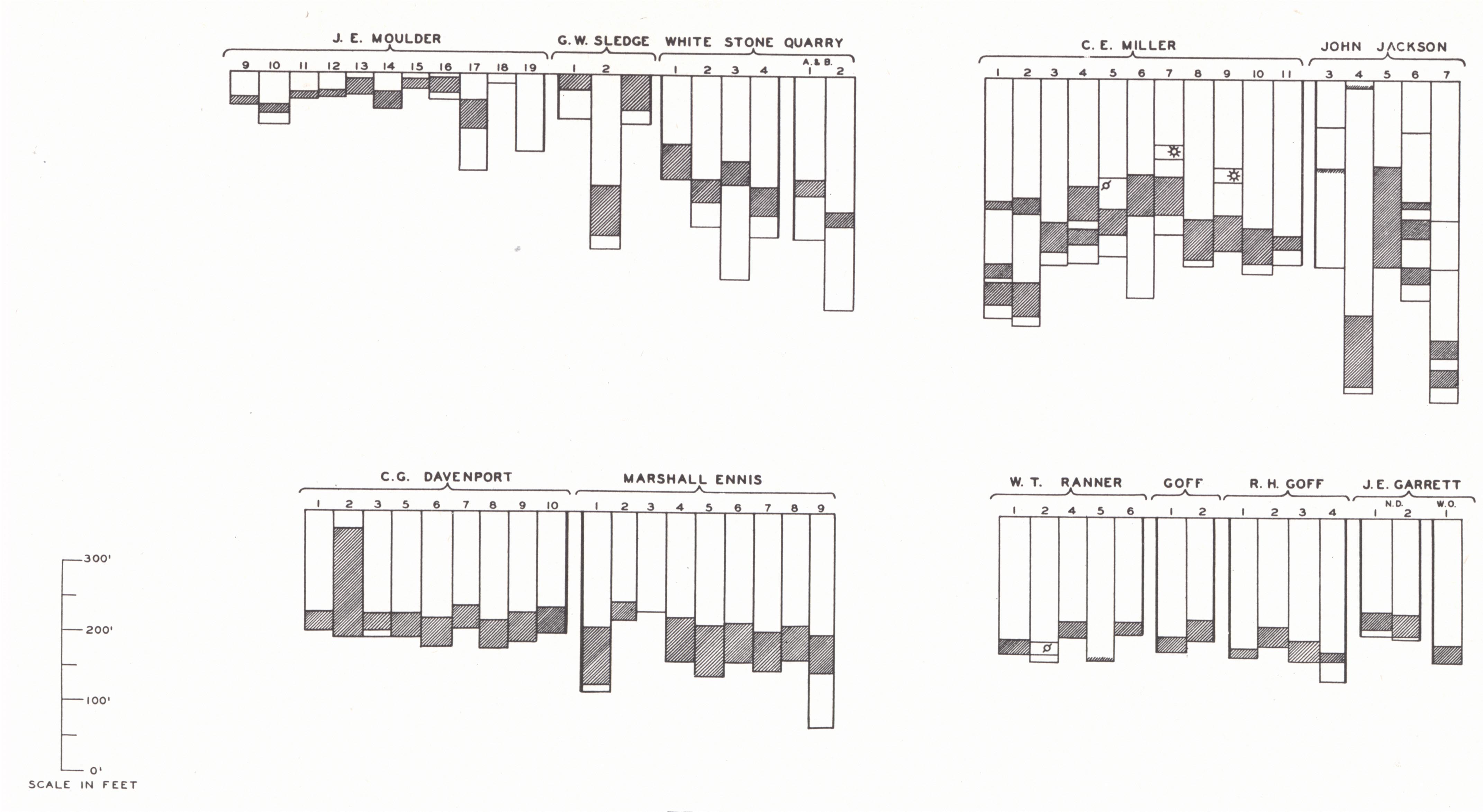
Warren County.—Production was first obtained from Warren County in the spring and summer of 1919 with the opening of the Moulder pool in the eastern edge of the county, which marked an extension of the Allen and Barren County fields. The pool came in with gushers from the Corniferous at 400 feet plus. In the same summer shallow oil was discovered close to the city limits of Bowling Green at 355 feet in a sand above the Chattanooga shale. In November the Davenport pool was opened, and in 1920 gusher oil was encountered in the shallow pay just east of the Davenport pool.
| Plate XCIV | |
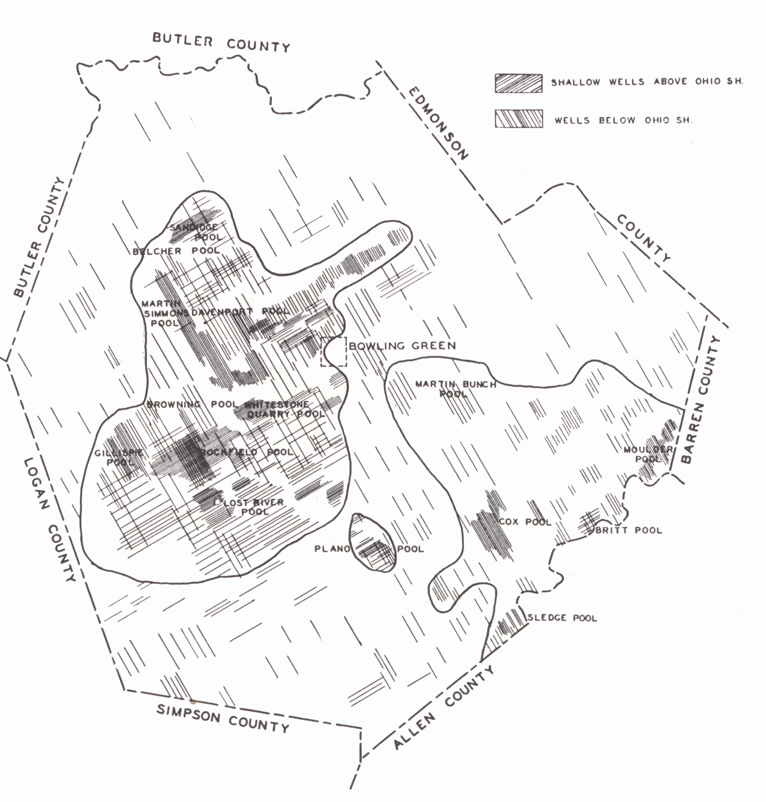 |
 |
| FIG. 2. Oil and gas pools in Warren County | FIG. 1. Well sections in Warren County |
Producing sands include:
(a) A limestone pay regarded as near the base of the St. Louis (St. Clair, 1921a). In the eastern part of the county it is 250 feet above the Chat-tanooga, increasing to 325 to 335 feet in the vicinity of Bowling Green and 350 feet to the northwest. Production is spotted. It was suggested by St. Clair that production was associated with depressions in the St. Louis-Warsaw contact. Lithostrotion basaltiforme was shot from one well. Wells came in large, some at 1,500 to 2,500 barrels initial, many 100 to 500 barrels. The decline, though, was also rapid. Some came in flowing salt water. Some pumped salt water for a time and then went to oil.
(b) A limestone pay a little above the Chattanooga shale in the eastern part of the county, perhaps the Beaver sand of Alien County and elsewhere. Some wells had an initial of 100 barrels but the decline was also rapid.
(c) Corniferous and Niagaran. Several pays are known below the Black shale which St. Clair grouped as follows:
1. Devonian (mostly in eastern part of the county).
a. A few feet below the shale,
b. About 45 feet below the shale.First wells in Sledge and Moulder pools with 100 to 1000 barrels initial were from this pay. The Moulder wells declined rapidly.
2. Niagaran (most of the Bowling Green production and west of town). Sixty-eight to 130 feet below the shale. This is the consistent deep producer of the Bowling Green field.
Little definite can be said as to the validity of these correlations, and distance below the shale is not a safe criterion. Wells in Warren, Allen, Barren, and Logan counties from which drill samples have been studied, (Freeman, personal communication) show in some cases a section of Jeffersonville and Beechwood up to about 85 feet thick. In others the shale is underlain by the Louisville limestone. Whether this is a regional or local variation is uncertain, but presumably some of the production is Devonian and some Silurian, as has been commonly believed. A well at Bowling Green and another at Scottsville in Allen County show several hundred feet of Silurian limestone which farther west in Muhlenberg County becomes 750 feet thick. The rapid wedging of this to the southeast probably has much to do with production.13
Salt water is present in the upper two pays but uncommon in the lower. Some gas has been found in what is probably the Ordovician in the White Chapel area.
The regional dip is 30 to 40 feet to the mile to the northwest. Little published work on structural relations is available.
(a) Stuart St. Clair (192la) found that most of the production is on the flanks of anticlines. He referred to a pronounced line of structures (on which some of the best wells had been drilled) along the base of the Dripping Springs Escarpment from the Morgantown Road north to the Barren River. Reference was made to the Briggs, Morris, Scott, Davenport, Moulder, and other producing domes. St. Clair gave a closure of 40 feet to the Davenport dome with a pay 6 to 20 feet thick. He stated that the best wells in the Niagaran sands conform closely to structure.
(b) Russell (1932) recognized an anticline with which production is associated. He regarded the beginning of this structure to have dated back to the Mississippian and referred to it as the "Bowling Green anticlinal nose" (p. 579).
(c) Subsurface work by the author in the Davenport pool region with contours drawn on top of the Black shale give a map with structural pattern much like that of the Big Sinking with many small closures and irregularities. On an earlier page and in figure 30 attention was called to the general alignment of "Corniferous pools" and the suggestion that pre-Ohio warping and beveling has been the major control of Corniferous production. The writer is inclined to regard the Warren-Allen-Barren counties production as similar in nature to that of the Big Sinking-Irvine. Some effect of post-Ohio deformation must be recognized even as in that field.
(d) St. Clair mentioned that: (1) Only one well west of Bowling Green produced from the Devonian14 (36 feet below shale), production from this pay being to the east. (2) Silurian production was in the western part of the county. The horizon was nonproductive east of the Richardsville Road and south and east of the Russellville Road, i.e. limited to restricted areas in the western part, just west and northwest of Bowling Green. This distribution is suggestive of a pre-Chattanooga beveling.
(e) The northeast extension of the Davenport pool developed in 1922 is a northeast-southwest "trend pool" and seems to be one located along the truncated edge of the "pay."
(f) Swartz's (1932) geophysical determinations have shown a nice correlation with production.
Oil below the Black shale is generally dark brown to green, with a gravity anywhere from 23° to 45°B'., usually 40° to 45°B'.
| PLATE XCV | ||
 |
 |
 |
| FIG. 1. Sections of the Corniferous in Warren County | FIG. 2. Pay zones of the
Corniferous in the Davenport pool, east-west section |
FIG. 3. Pay zones of the
Corniferous in the Davenport pool, north-south section |
Allen County.—Allen County lies on the western flank of the saddle in the Cincinnati arch separating the Jessamine and the Nashville domes. It is in the edge of the Cumberland River section of the Pennyroyal and shallowness of production is shown in the outcrop of the Chattanooga shale and older beds in valleys in the southern and eastern parts of the county.
| Plate XCVI |
 |
| Corniferous in Allen County |
Discovery of oil was associated with the early salt industry centering around Port Oliver 11 miles north of Scottsville. Two well known oil springs were located on Main and Little Trammel creeks. The latter led to drilling by Confederates during the Civil War. Active prospecting followed the war as Federal soldiers who had observed these and other oil and gas seeps returned. The Uriah Porter well drilled in 1866 or 1867 3 miles west of Scottsville, flowed for a time and is said to have produced 100 to 500 barrels a day of a highly sulphurous oil. The producing horizon is not known.
Drilling continued sporadically and small booms followed the finding of Trenton oil in Ohio and Indiana in 1887, and the opening of the Ragland field in 1903. Real development began in 1913 under the influence of higher prices and later with the opening of the Irvine field. One hundred and thirty wells were reported drilled in 1916, of which three-fourths were commercial producers and the big development was on. The Rodemer pool was discovered in 1917, and it is reported that 102 out of 138 wells were producers. Production was mainly south of Scottsville and many wells showed 30 to 35 barrels initial at depths of 70 to 520 feet. The Gainesville pool (1919) was the largest in the county with 360 wells at 190 to 520 feet. All but 75 were producers with initials of 25 to 150 barrels. The Gainesville pool with an area of more than 7 square miles was unusual. Others averaged 1 to 2 square miles each.
Production comes from just under, to 165 feet below the Chattanooga shale. In some wells three pays were recognized, in others but one, and there seems to have been little geographic continuity, or consistency in interval. With both the Mid-Devonian15 and Niagaran16 shown on outcrop within the county immediately beneath the Chattanooga shale, it is difficult to interpret the stratigraphy of these pays, and probably both are involved. (See comments on Warren County.) Freeman's map (1941, fig. 5) suggests the presence of pre-Jeffersonville Onondago, Oriskany, and Helderberg in addition to the Niagaran beneath the shale. These early Devonian beds are not known in outcrop in Kentucky.
| PLATE XCVII | |
 |
 |
| FIG. 1. Structure map showing main pools
of Allen County (Shaw and Mather, 1919) |
FIG. 2. Geologic and structure map of a
part of Allen County. Contours on top of Chattanooga shale (ibid.). |
A small amount of oil is found in the Beaver sand in the western part of the county, a producing limestone 2J to 68 feet above the Chat¬tanooga shale. The oil is amber in contrast to the dark green oil of the Corniferous.
The regional dip is about 30 feet to the mile to the northwest interrupted by a number of minor flexures. The North Petroleum and Rodemer fields occupy two of the more prominent anticlines (Shaw and Mather, 1919), and the Wildwood was regarded as probably anticlinal. Miller (1919) called attention to an unpublished structural map of the Gainesville pool by Hudnall contoured on the top of the Chattanooga shale, which showed a dome 2½ by 3 miles with orthodox alignment of oil, gas, and salt water. Some anticlinal structures are nonproductive and some production is synclinal.
Barren County.—Production is a northeasterly extension of the Allen County fields and to the north is continuous with that of Hart County. Early drilling dates back to development of Boyd's Creek in 1865. The most noteworthy strike (Miller, 1919) was the Kinslow well which flowed 150 barrels per day for a time and was then pumped. Production was very shallow averaging 120 feet. The Trigg well near the mouth of Boyd's Creek was drilled in 1868. Others followed at intervals with the major development within the past two decades.
 |
|
FIG. 33. Outline map of Barren County, |
The main producing formation is Corniferous, and production is encountered within a few feet of the Chattanooga shale. The stratigraphy of the pay is probably the same as that of Warren and Allen counties.
Amber oil occurs just above the Chattanooga shale in the Austin pool and is known in small quantities elsewhere at a somewhat higher level. Butts (1919b) referred this pay, the Beaver sand, to the Ft. Payne. In the Hiseville region it has been an important gas producer, and one well cross the line in Metcalfe County was reported at five million cubic feet.
Some production has been found in the Lecta pool in the Yellow Cap (Brassfield dolomitic limestone). The wells are small but hold up well.
In regard to structure Butts (l919b) mentioned a steepening of the dip in the vicinity of Glasgow northeastward, northwestward, and westward with a flattening to the southeast, thus a terrace. He also mentioned a number of examples of anticlinal occurrence and called attention to the Moulder pool in the adjoining edge of Warren County which is anticlinal.
No detailed information is available on production in these pools and a reasonable picture may be obtained by regarding the area as part of a belt including Allen, Warren, and Hart counties, and possibly the Green River gas field. In these fields the significance of pre-Chattanooga warping has been emphasized.
 |
| FIG. 34. Well sections in Green and Taylor counties |
GROUP VII
Campbellsville Gas Field (Green River gas field).--Little effort was made to develop this field in Green and Taylor counties until 1919 when the Green River Gas Company took over most of the wells, and lines were laid to Greensburg and Campbellsville.
Production is from the "Corniferous" usually at 200 to 600 feet. Some wells came in as high as four to five million cubic feet and with a rock pressure of 35 to 40 pounds. Total original open flow was about 170 M, but pressure dropped off rapidly. The pay is normally within a few feet (0 to 15 feet) of the Black shale but occasionally at a greater interval, sometimes from a second pay about a hundred feet below. In Marion, Casey, Boyle, and western Lincoln counties the Boyle limestone overlies the Ordovician with the Silurian out. In Cumberland County to the south the Black shale rests on the Upper Cincinnatian. It is thus problematic as to just what is involved in the section immediately below the Black shale, though the Silurian is not necessarily ruled out.
The field lies rather high on the axis of the Cincinnati arch. Very worth-while observations have been made by Russell (1932, pp. 238, 241).
"The trend of some of the pools seems to be determined by the structural trap formed by the termination of the reservoir rock against the unconformity. The reservoir rock in these pools contains salt water down the dip, and the belt where it is cut off by the unconformity at the base of the Chattanooga shale is approximately parallel with the strike. The Campbellsville gas pool is evidently of this type. The regional dip in the vicinity of this pool is northwest, and on its northwest side salt water is found in the reservoir rock. The pool itself is long and narrow with a northeast-southwest trend. On the southeast side, it is reported that no water is obtained beneath the Chattanooga shale, probably because the reservoir rock was removed by erosion before the deposition of the shale. The accumulation is only a few feet beneath the base of the shale, and it is possible that the porosity of the reservoir rock has been produced or increased by solution beneath the unconformity. That the producing formation is remarkably porous is indicated by the fact that, although the rock pressure is reported to have been only 39 pounds per square inch, some of the wells produced-as much as 3,000,000 cubic feet of gas per day ....
"In some of the pools there are, however, suggestions that some of the oil and gas may have migrated up the dip 10 or 20 miles to reach the accumulation. This relatively long migration may have occurred in the formation of the Campbellsville gas pool and the gas pool in northeastern Hart County. For nearly 20 miles west and northwest of the Campbellsville gas pool a porous horizon containing showings of oil and gas lies close under the Chattanooga shale. Also, there are anticlinal noses extending west or west-northwest, which may have guided the gas toward the pool as it moved up the dip. An interesting feature of these pools is that, although showings of oil are plentiful in the water horizon down the dip, the production is almost entirely gas. This suggests that the gas has been able to move up the dip and accumulate more readily than the oil."
GROUP VIII
LeGrande Pool.17—The LeGrande pool was discovered in the fall of 1930 by random wildcatting. When first completed, some of the wells flowed several hundred barrels a day, along with considerable gas at a depth of about 600 feet. It lies in the gently rolling St. Louis lowland with its innumerable limestone sinks and thick residual soil. Most of the production is obtained from two zones of porous dolomitic limestone in a zone about 100 feet thick below the Chattanooga shale. These were regarded by Russell (1934) as probably occurring within the Louisville and Laurel limestones. Determinations by Freeman (1941) corroborated this interpretation.
(a) The "Corniferous" is the pay 1 to 40 feet below the Black shale. The rock drills fine and contains a considerable amount of true quartz sand. Little or no salt water is found in the LeGrande pool, but it does occur in the northern part of the county. Initial production is flashy and wells show from 50 to 2,400 barrels. The decline is rapid.
(b) The "Blue sand" is the pay normally 70 to 100 feet below the base of the Black shale. This formation drills with coarse flaky blue-grey limestone chips and very little sand. Salt water occurs. Production is not quite so flashy as in the Corniferous but is longer lived. Wells commonly give 40 to 50 barrels flush, drop to 4 or 5 barrels within the year, and 1 to 1½ barrels at the end of the second year.
(c) Gas has been found in scattered wells over the county in the Beaver sand (Black Lime) just above the Black shale. Oil has been found in only two (Russell, 1934). There is no saltwater. Russell regarded this production as determined by localized porous zones in the Black Lime.
(d) Production has also been obtained in the vicinity of Lecta in Barren County from the Yellow Cap (Brassfield), a magnesian limestone. The wells are small, 10 to 15 barrels, but decline slowly.
The LeGrande pool is the most productive in the county and covers an area of about 3,000 acres. Production is from the Corniferous with little or no salt water. The pay is rather thin, very porous, and with low rock pressure. Production has declined rapidly. Gas occurs in the top of the pay and up dip. Russell (1934) called attention to the unconformity at the base of the Chattanooga, the latter truncating older strata, including the pay, and resting on progressively younger rocks toward the northwest. It is the truncation of the pay horizons, along with porosity and permeability in the pay and proximity to a source rock, that governs production. It is a typical "trend" pool paralleling the intersection of the Silurian limestone ("Corniferous") and Chattanooga shale, which approximates the strike of the surface rocks. The belt of production extends across several anticlinal noses without being deflected.
Some recent observations by the late J. C. Wilson (personal communication) indicate the angular relationship.
(a) In the main, LeGrande pool "Corniferous" production is about 15 feet below the Black shale. On the eastern edge of the pool it occurs immediately below the shale. The Green Whitloe No. 1 on the eastern edge drilled itself in when about 2 feet above the bottom of the Black shale. No salt water is found and farther west the "pay" is dry.
(b) In the Park district to the southeast the pay encountered just beneath the Black shale drilled like the Blue sand and production acted like and held up like that from the Blue sand. These points were puzzling and were in general ignored because of the position of the pay just beneath the shale. The production here is apparently from the Blue sand where it emerges from beneath the "Corniferous" and is in turn truncated by the Chattanooga shale. This is the only oil from the Blue sand.
(c) No part of any pool produces from both pays.
A recent geophysical (resistivity method) test survey in this pool (Swartz, 1932) seemed to check rather well with known distribution of production.
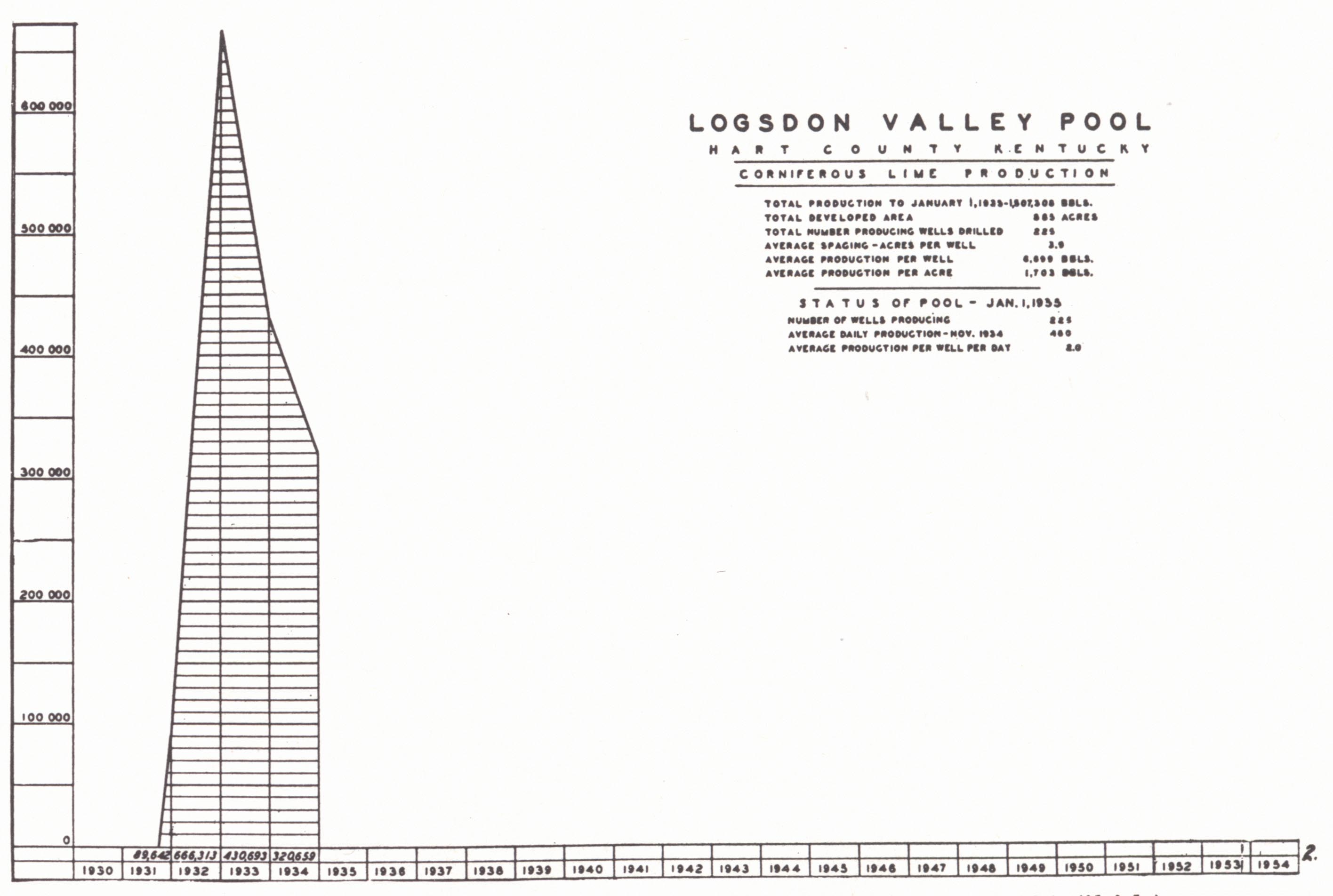
Logsdon Valley Pool.18—This pool about 3½ miles west of Munfordville shows structural relationships similar to those of the LeGrande pool, al-though the wells are longer lived. The producing horizon is similarly "Corniferous," close under the Black shale. Little or no salt water is en-countered. The same general factors seem to have controlled accumulation, though later structure, as determined on the top of the Black shale, seems to have had a modifying influence. Gas production is principally on an anticlinal nose. Some oil production, though not all, is similarly located.
| PLATE XCVIII | |
 |
 |
| FIG. 1. Production chart,
LeGrande pools, 1930-1934 (Kentucky Oil and Gas Association, 1935). |
|
 |
|
| FIG. 2. Production chart,
Logsdon Valley pool, 1931-1934 (ibid.) |
FIG. 3. Well sections in Hart County |
| PLATE XCIX | |
 |
 |
| FIG. 1. Structure map of LeGrande oil pool
(McClurkin—see under Russell, 1934). Contours on top of Chattanooga shale—solid lines; on base' of Chattanooga shale— broken lines. |
FIG. 2. Structure map of
Logsdon Valley oil pool (ibid.). Contoured on top of Chattanooga shale. |
Priceville Pool.19—The Priceville oil and gas pool is a small pool located in the northwestern part of the county. It occupies a closed structure with steep southward dip and either fault or steep dip on the north. Production is from the Blue sand 80 to 100 feet below the Black shale at a depth of about 1,000 feet. The "Corniferous" is tight and nonproductive. Gas occurs high on the structure, oil below, and salt water down the dip. A little gas is found in a shallow pay, probably the St. Louis. Some gas wells are good for 2,000,000 cubic feet and oil wells are reported capable of producing 50 to 75 barrels.
|
"CORNIFEROUS" OIL AND GAS |
|
|
Magnolia Gas Pool:
"The Magnolia gas pool in the northeastern corner of Hart County is the only pool in the county in which production is found in both the Blue sand and 'Corniferous.' This 'Corniferous' production is found one to 35 feet beneath the base of the Chattanooga shale, and the Blue sand about 80 feet beneath the base of the Chattanooga shale. The Blue sand has not been completely drilled through and its exact thickness is uncertain. The production from the Blue sand is confined to the highest parts of the structure. The production from the 'Corniferous' covers a much larger area, and may extend beyond the closed area. This is probably because the 'Corniferous' loses its porosity and permeability in the eastern portion of the structure. Consequently the closure in the 'Corniferous' is due not only to the eastward dip along the axis of the structure, but also to the termination of the reservoir towards the east. The Blue sand, on the other hand, has been found porous in every well which has been drilled to it in this vicinity" (Russell, 1934, p. 10).
According to D. J. Jones (personal communication, 1941) there are 11 wells shut in waiting for pipe line, ranging up to 1¼ M open flow and ±80 pounds rock pressure. About 2000 acres are now productive.
In regard to source rock in these several pools, Russell (1934) questioned the probability that the Chattanooga shale was the source rock for production in the Blue sand, and he is not satisfied that it was the source of "Corniferous" oil.
Footnotes
1 Miller, 1919; Jillson, 1919.
2 Freeman (1939a) regarded the lower 40 typically St. Peter. The upper part is
fine grained and calcareous and possibly Stones River.
3 See figure 36, page 353 for other Trenton pays.
4 Gas does occur, though, low in the Corniferous 500 and 600 feet below the
shale in the Mine Fork (Magoffin County), Flat Gap (Johnson County), and Auxier
(Floyd County) fields as well as in the Big Six near Prestonsburg.
5 Paper read before the Appalachian Geological Society, November 8, 1935.
6 From a symposium prepared by the Appalachian Geological Society, 1935.
7 The situation seems to be somewhat like that involved in the distribution of
upper Corniferous production and that of the Big Six and is outlined in a paper
presented before the meeting of the American Association of Petroleum
Geologists, April, 1942, at Denver, Colorado, by R. C. Lafferty and R. N.
Thomas. (See plate CV and notes on pp. 358.)
8 These notes taken from L. B. Freeman, 1938.
9 Some "Corniferous" gas has been found in the Isonville (southern Elliott
County), Flat Gap (northern Johnson County), Mine Fork (northeastern Magoffin
County), and Auxier (northern Floyd County) fields. These are all in the region
of the Paint Creek uplift and are mentioned in connection with Weir sand
production of that region (p. 355).
10 A. M. Miller, 1919, gives the discovery well as on the farm of Uncle Tommy
Ragland.
11 See Irvine-Big Sinking group.
12 These notes are from a study of this field by Phil M. Miles (Master's thesis,
University of Kentucky, 1939) based on data supplied by the Petroleum
Exploration Company of Lexington through the courtesy of Earl Wallace.
13 Structural relationships are summarized in a diagrammatic cross section (Pl.
XXXIII, after Freeman, 1941).
14 As defined by that author.
15 Miller (1919) said only the Beechwood member of the Sellersburg, and this is
confirmed by Savage (1930a).
16 Miller (1919) said up to 60 feet of Osgood to Louisville.
17 Notes mainly from Russell (1934).
18 Notes from Russell, 1934.
19 Notes from Russell, 1934.
20 Sunnybrook production is considered separately with the Burkesville field.
21 The recent report by Kendall Born and H. B. Burwell (1939) on Clay County,
Tennessee is the first comprehensive published work on this field and becomes
the outstanding reference work. His conclusions are equally applicable to
Cumberland, Clinton, and Monroe counties, Kentucky.
22 Mainly Weir sand (Johnson, Lawrence, Magoffin, and Elliott counties).
23 Notes supplied by George Straughan.
24 Now commonly spelled Barlow in referring to the sand.
25 Notes from E. A. Barnes.
26 Notes from E. A. Barnes.
27 Notes from E. A. Barnes.
28 Notes from E. A. Barnes.
29 Notes from E. A. Barnes.
30 Notes from R. C. Lafferty.
31 Notes from R. E. Stouder.
32 These notes from information supplied by D. J. Jones.