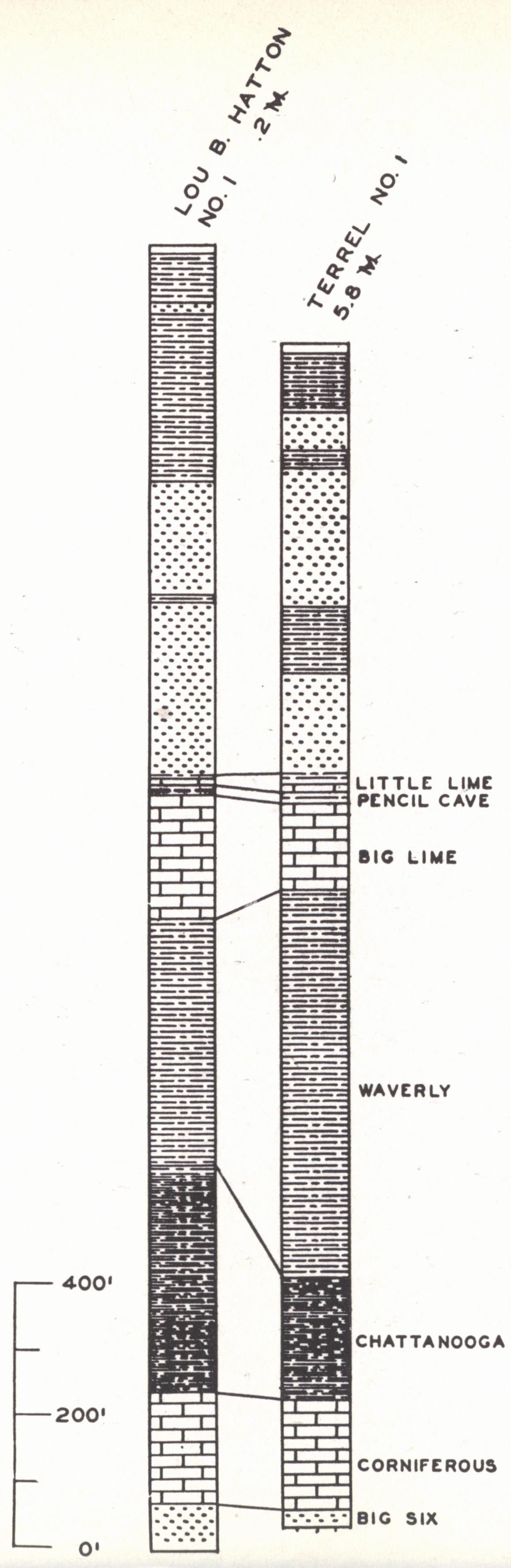

showing Big Six sand,
Breathitt County.
Browning, 1919).
Sections
A. Introduction
B. Pays
C. Corniferous production
D. Big Six gas field
E. Knox-Whitley counties pools
F. Wayne County field
G. Cumberland River field
H. Big Lime production of Owsley County
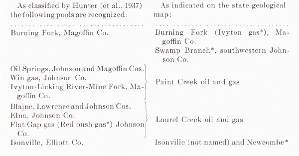
I. Production of the Paint Creek uplift
J. Gas fields of Floyd, Pike, Knott, and Martin counties
K. Boyd County gas field
L. Berea production of Lawrence County
M. Owensboro field
N. Miscellaneous small oil and gas pools of western Kentucky
O. Gas pools of Meade and Breckinridge counties
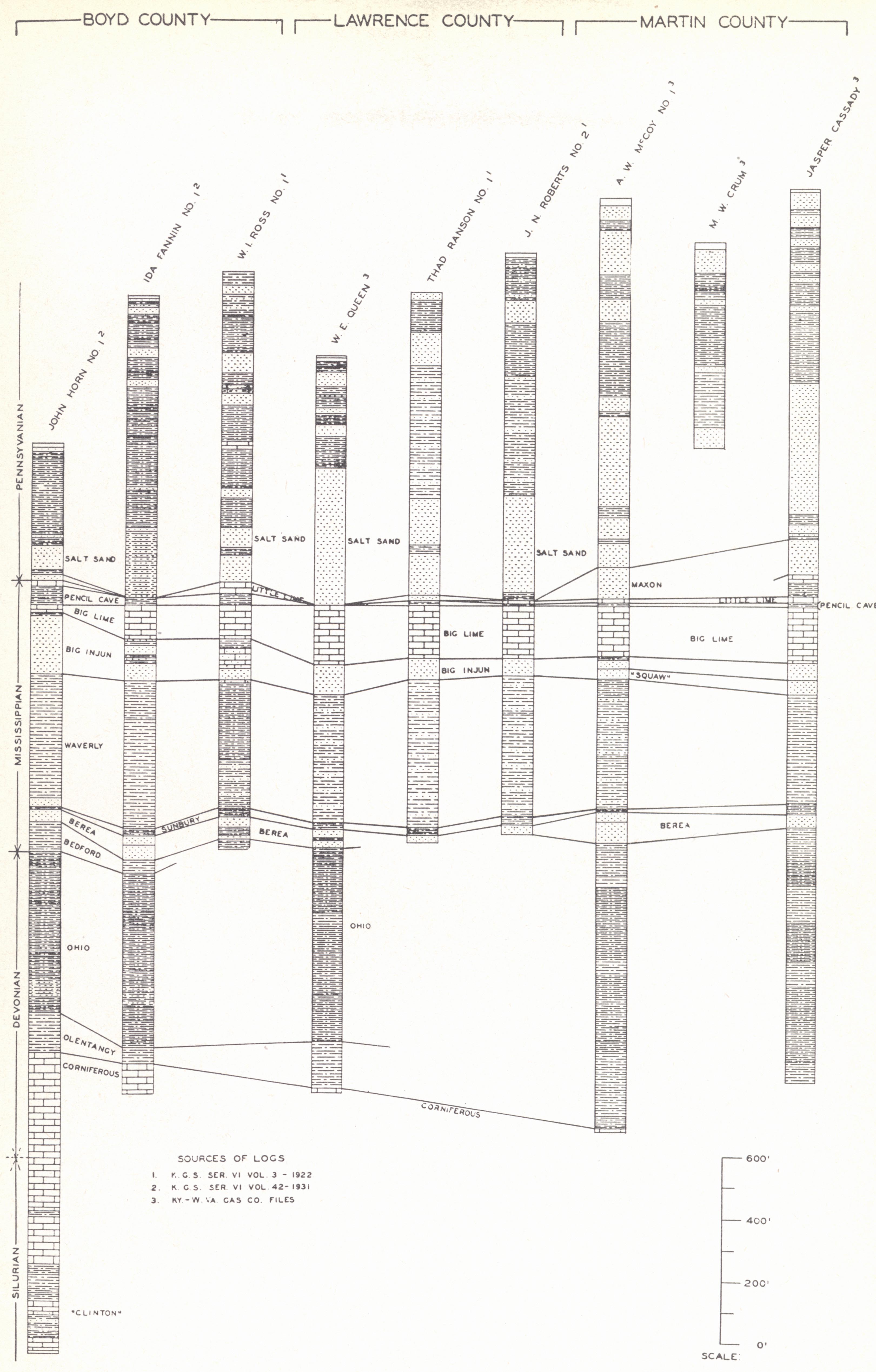
SECTION D—BIG SIX GAS FIELD (BIG SIX SAND)
The Big Six gas field is in the vicinity of Taulbee, Breathitt County, and was opened in September 1918, by the Big Six Oil Company with production in the discovery well at about 1800 feet, open flow of 3½ M and rock pressure of 525 pounds. By the winter of 1920-1921 a ten-inch pipeline was completed and deliveries to the Central Kentucky Natural Gas Company begun. Five producers gave a total open flow (Jillson, 1922c) of 18 M. The largest well was good for 71/5 M. During 1935 the pipeline serving the field was removed, and the few wells not completely depleted were used locally (Hunter, 1937).
| PLATE C | |
|
|
|
| FIG. 1. Well sections showing Big Six sand, Breathitt County. |
FIG. 2. Wilhurst oil and gas
pool, Breathitt County (from county map, Browning, 1919). |
Production comes from the Big Six sand, 175 to 200 feet below the Chattanooga shale and above the red rock regarded as Clinton.
The pool with its seven producing wells is a local development on the south flank of the Wilhurst anticline. The failure of this anticline to produce over a larger area and the absence of production on other favorable structures (e.g., Cope Fork dome) indicate the control to be in the nature and attitude of a lenticular sand body. With the abandoning of the field probably little will ever be known. Six miles to the west a little oil and gas has been produced near Wilhurst (same structure) and a little gas also a few miles to the north in the edge of Wolfe County. Both of these produce from the Corniferous.
What is apparently the same sand has more recently become an important gas producer near Prestonsburg and Paintsville (see pages 291 and 359).
| PLATE CI | |
 |
 |
| FIG. 1. Well sections in
Whitley and Knox counties. |
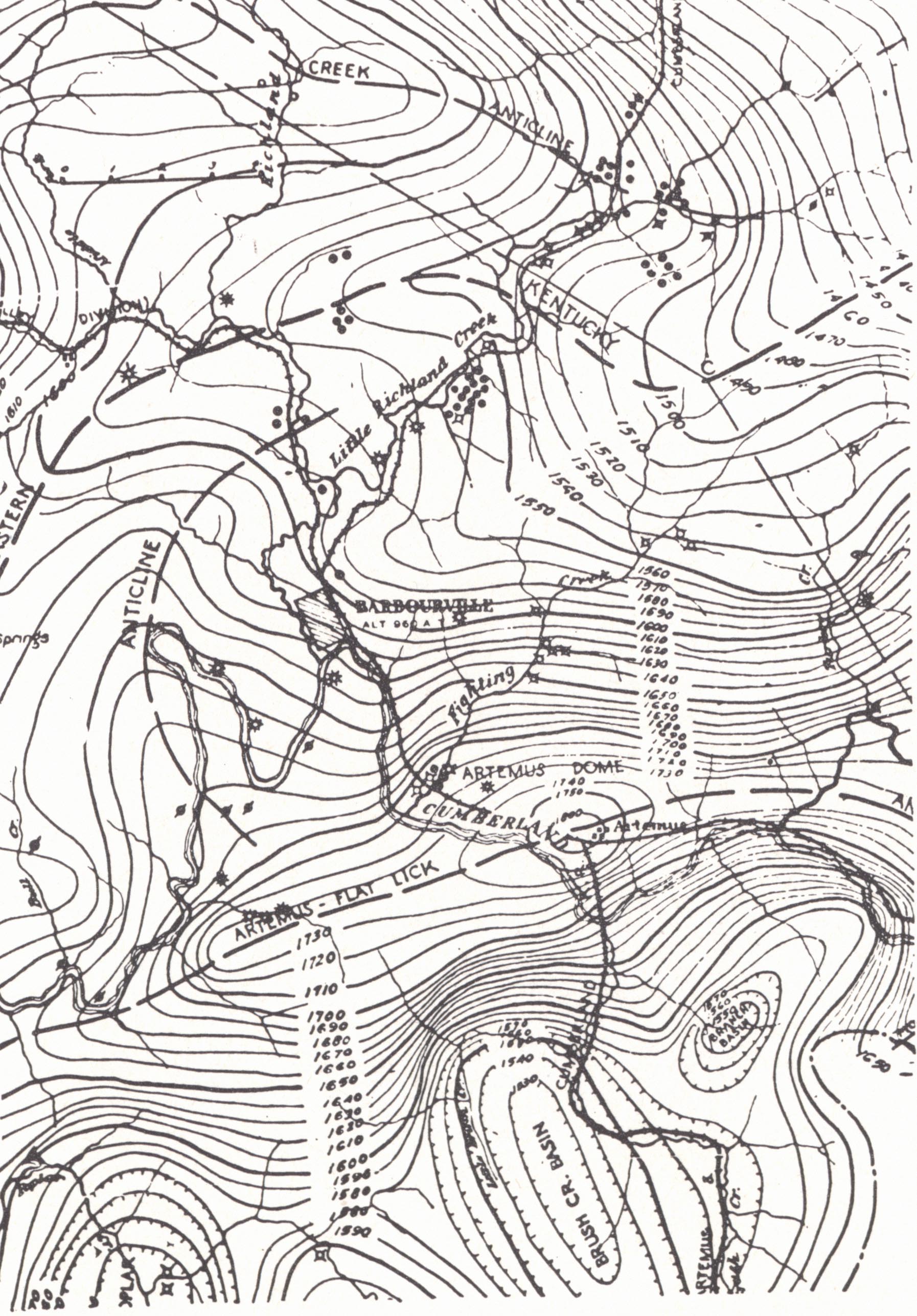
FIG. 2. Structure map of a part of Knox
County showing Artemus anticline and Little Richland Creek production. Contoured on the top of the Fire Clay (Dean) coal (Theis, 1925). |
SECTION E—KNOX-WHITLEY COUNTY POOLS
Oil was discovered in Knox County on Little Richland Creek six miles east of Barbourville in 1840 in drilling for brine. The well flowed at the rate of about 100 barrels per day at a shallow depth. Another well drilled 9 miles north of Barbourville in 1864 was a producer and in 1867 the Hughes No. 1 five miles northeast of Barbourville, the first well drilled for oil, is said to have flowed at 400 feet. In 1896 some oil was found on Road Fork of Stinking Creek. In 1901 gas was encountered at Barbourville at 415 feet. The S. H. Jones drilled in this same year was a gusher at 380 feet and resulted in the drilling of 100 wells in the county in 1902. Production was from the Big Injun and from the Salt Sands, referred to in this part of the state as the Wages, Jones, and Epperson. The latter are erratic in occurrence and character.
Three pools are recognized:
(a) Little Richland.—The Little Richland is Kentucky's second oldest oil pool. No figures on production are available (Hunter et al., 1937) for the oil was shipped out by water or used locally. According to Munn (1912a) many of these wells made a good showing when drilled in, but after being pumped a few days or weeks declined rapidly. Production was from the Salt Sands at only a few hundred feet. The gas well drilled at Barbourville in 1901 was drilled on into salt water and ruined.
(b) Himyar.—In 1931 and 1932, eighteen gas wells were drilled in the Himyar pool, developing 15 M open flow from the Corniferous, Maxon, and Brown shale. Hunter (et al., 1936, p. 8) reported the rock pressure in all sands both shallow and deep at about 300 pounds. "The only explanation the authors can reasonably assume is the fact that the Artemus anticline south of the gas field is traversed by a fault. This, with other disturbances caused by the Pine Mountain overthrust fault, 15 miles to the southeast, has permitted the pressures of the various horizons to equalize." In this paper Hunter listed the structure as a closed and faulted anticline.
(c) Indian Creek Gas Pool.—The Indian Creek gas pool, discovered in 1927, is a producer from the Big Lime at about 1,500 feet, with also a little from the Corniferous. In 1936 there were only three producers and six dry holes and abandoned wells (Jillson, 1937). The discovery well was good for 5 M. This dropped to 1.5 M in a week and later went to salt water. The original rock pressure was 285 pounds.
Structural features in this region are shown in plate CI, figure 2. The Himyar pool occupies the north flank of the Artemus-FIat Lick anticline and a northward projecting nose from the main structure. The Little Richland Creek accumulation is low in the Eastern Kentucky geosyncline, a control apparently by lithology. The Indian Creek pool is associated with a closed anticline (Jillson, 1937). Big Lime production is regarded as from crevice accumulation.
The regional Corniferous isopach map (fig. 31, p. 311) does not include Knox County. However, available logs show a big variation in the thickness of the Corniferous, even to its local absence. This may be of importance in the Artemus-Himyar pool involving an updip wedging of this "sand" or pre-Chattanooga deformation.
Williamsburg Oil and Gas Pool (Whitley County).—The Williamsburg pool was developed in 1902 with production from the Salt Sands (Williams-burg sand) at depths of 300 to 800 feet. The first well flowed 20 to 35 barrels. Deepening of some of the wells in later years led to the discovery of gas in the Big Lime. The largest of these gas wells were good for 3.5 M. Rock pressure varied from 225 to 240 pounds. Oil production never exceeded 175 barrels per month (Hunter, et al., 1936).
Surface structural relationships are shown by Jillson (1926) and Chisholm, Hudnall, and Jillson (1927). The occurrence is low on the front of the Williamsburg anticline on the northwestern flank of the Eastern Kentucky geosyncline. Jillson (1926), on the basis of a thinning of the Lily coal-Pennington interval toward the anticlinal axis, inferred earlier folding and a more pronounced anticline in the Mississippian rocks. Big Lime production is regarded as crevice. The gas has been used locally.
SECTION F—WAYNE COUNTY FIELD20
Development of this field began in the eighties and continued into the early part of this century. Drilling was renewed in 1921-22. The first strike was that of the Fairchild well drilled to 1,100 feet in 1886.
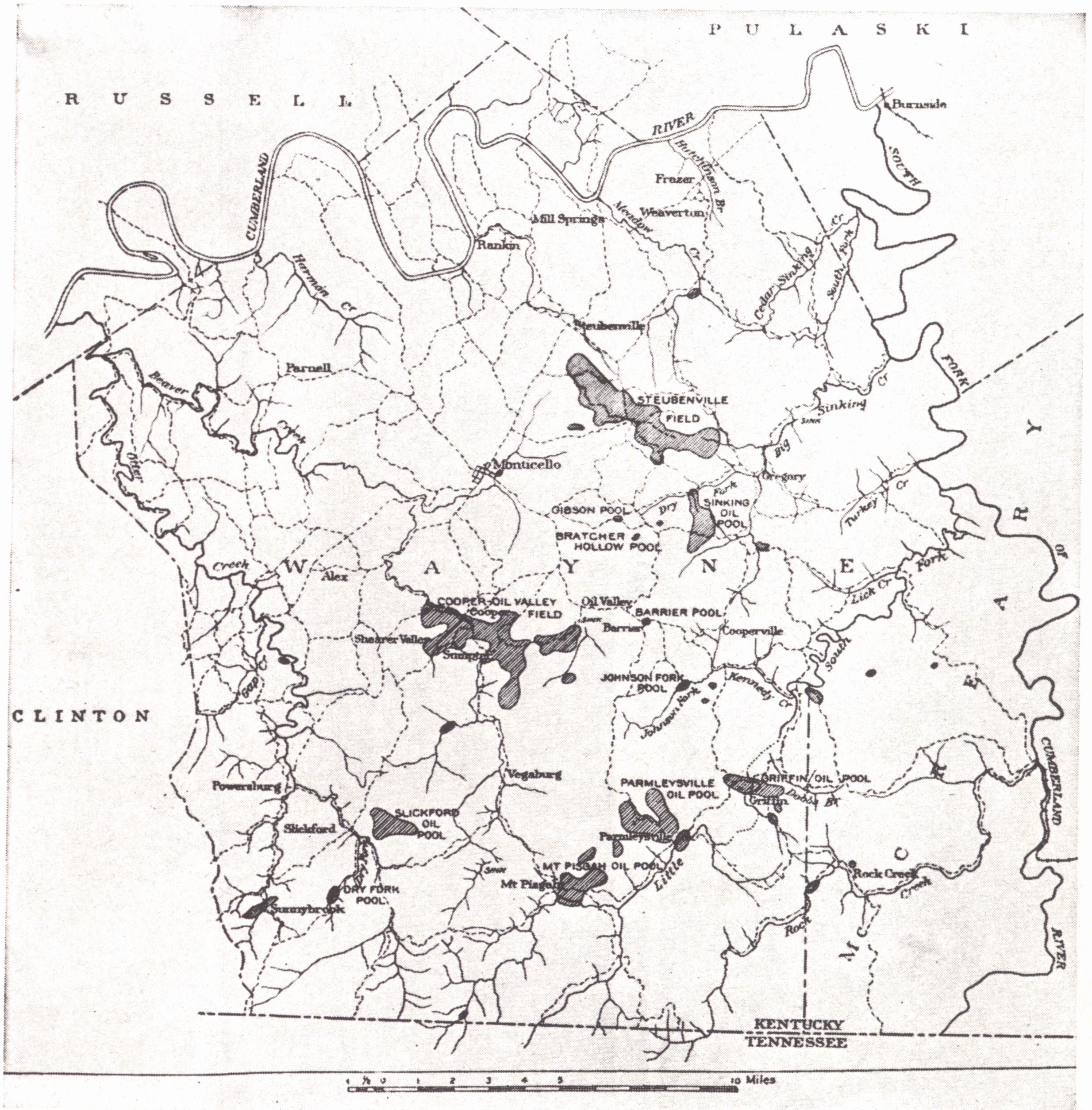 |
| FIG. 35. Sketch map of Wayne County, showing
oil and gas pools (Munn, 1914) |
Producing formations include:
(a) Beaver Creek Sand.—The Beaver Creek sand is a cherty, geode-bearing limestone usually only a few feet (sometimes up to 60 feet) above the Chattanooga shale. It is erratic in occurrence both as to stratigraphic position and horizontal extent. In the Parmleysville pool initial yield was two to 40 barrels. In the Sinking field it was usually less than 25 barrels, though one well came in at 435 barrels and was making 200 at the end of four months. In the Steubenville pool some of the better wells had initials of 100 to 500 barrels. Decline was rapid. Drilling depth varied from a few hundred feet up. Salt water is absent, or present only in small quantities.
(b) Stray or Corder Sand.—The Stray sand consists of 10 to 30 feet of cherty, geode-bearing limestone near the top of the Waverly (Keokuk) 175 to 225 feet above the Chattanooga shale. Production from one well in the Corder pool is reported as coming from a creviced grey limestone. Salt water occurs. Some of the initial production was flashy but the wells were short lived. One well in the Parnell pool reported 2,000 barrels initial.
Gas occurs in both pays and is reported up to 3 M feet. Rock pressure ranges from as low as 50 pounds to 340 pounds (closed) in one well near Monticello.
Structural relationships are not well understood. Munn (1914) recognized a tendency of Beaver production to occupy the sides and bottoms of structural troughs. This is in keeping with the meager presence of salt water. The spotted character indicates a definite control of production by the distribution of reservoir.
| PLATE CII | |
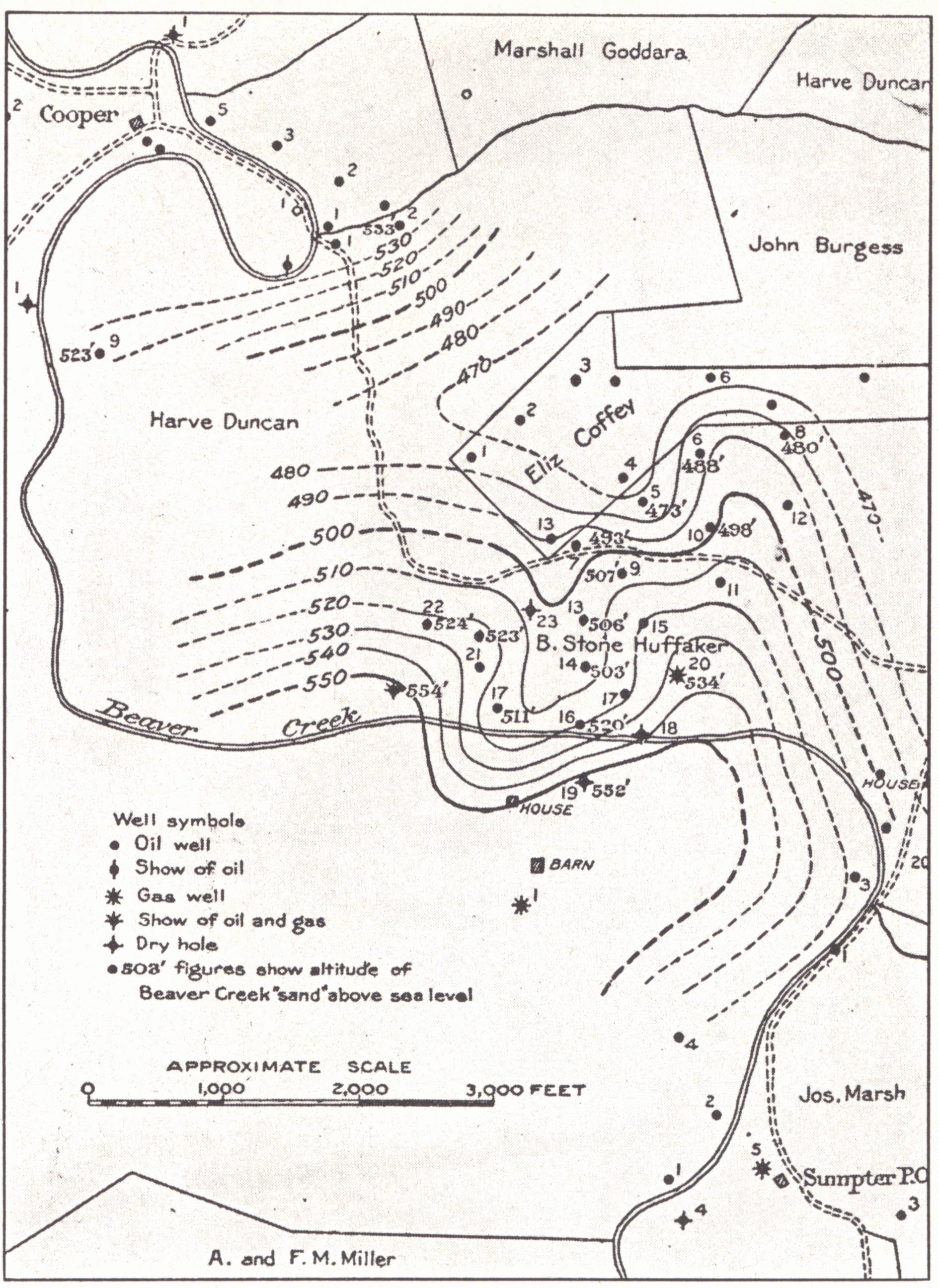 |
 |
| FIG. 1. Structure of part of
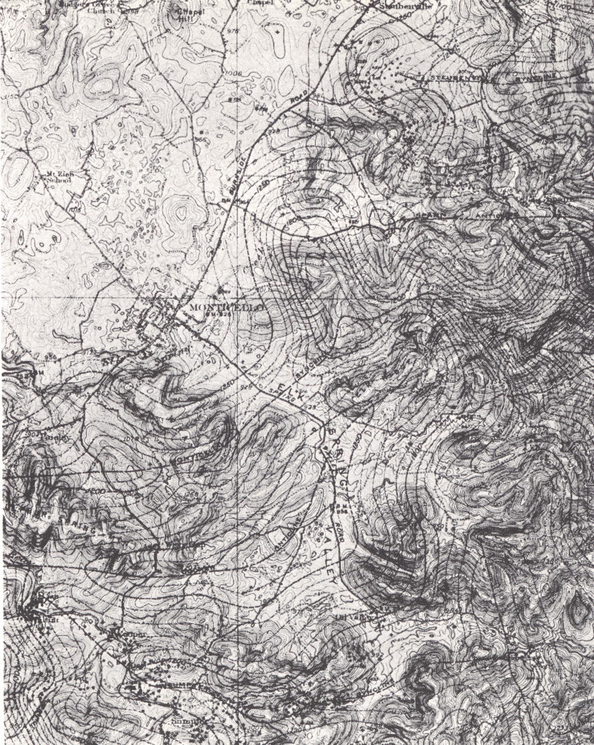
Cooper Valley oil field, Wayne County. Contoured on Beaver Creek sand (Munn, 1914). |
FIG. 2. Southeastern part of
the Monticello quadrangle with oil pools and surface structure. Contoured on top of Spann limestone (ibid.). |
The productive belt of the Steubenville pool occupies the head of the Steubenville syncline but extends eastward on the southern flank, and in the vicinity of Spann occupies the crest of the Spann anticline (surface structure on Spann limestone, plate CII, fig. 2).
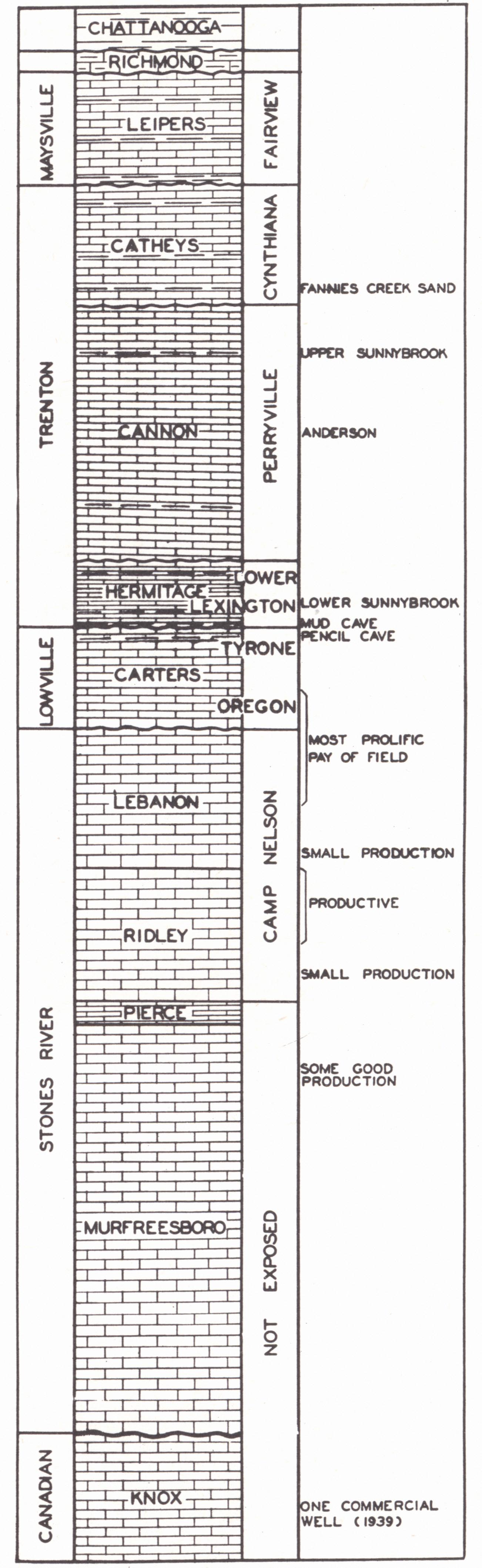 |
| FIG. 36. Stratigraphic section for the Cumberland River oil field (after Born and Burwell, 1939a) |
The Cooper Valley oil field follows the Sumpter syncline (surface structure on the Spann limestone) but rises westward well up to the axis of the Cooper anticline. Structural relationships, as determined on the "pay" of a portion of the field near Sumpter indicate production occupies the northern flank of a nose or southern flank of the adjoining syncline.
Production in the Mt. Pisgah pool occupies the head (western end) of a plunging syncline (structure on the "sand").
Structural relationships are not so well known for the Parmleysville oil pool. Munn (1914, p. 58) suggested that the pool apparently "occupies a broad, flat terrace or a flat-topped anticline in the Beaver Creek 'sand,' where it lies at an altitude of about 400 to 475 feet above sea level."
Surface structure in this county is usually worked out on the Spann limestone, a 3 to 15-foot, cherty, geode-bearing limestone of the Pennington formation. Munn's stratigraphic section shows a sandstone member in the "Newman" limestone. This occupies the position of the Cypress sandstone which is well known in outcrop to the south along the Cumberland (Pottsville of Kentucky) Escarpment of Tennessee.
SECTION G—CUMBERLAND RIVER FIELD21
The Cumberland River field dates back to the Martin Beatty (1819) and Great American (1829) wells. A number of large wells were drilled in the sixties. The strike at Sunny brook in Wayne County in 1901 resulted in extensive drilling in the several years following, but rapid decline and local taxes brought about the abandonment of the field. Again in 1922 there was renewed drilling with the same story of spotted production, frequent gushers and usually rapid decline. The country is rugged as a result of deep dissection by the Cumberland River and its tributaries. As indicated earlier (p. 189) thorough dissection has taken place not only because of proximity to the river but also because of the outcropping of Fort Payne-Waverly, Chattanooga, and older rocks—a stratigraphic assemblage typical of the Knobs. It is a region of shallow, spotted production and usually rapid decline. In some instances wells with small initial have held up well. The field lies on the axis of the Cincinnati arch and numerous small folds are well shown in the river and creek exposures.
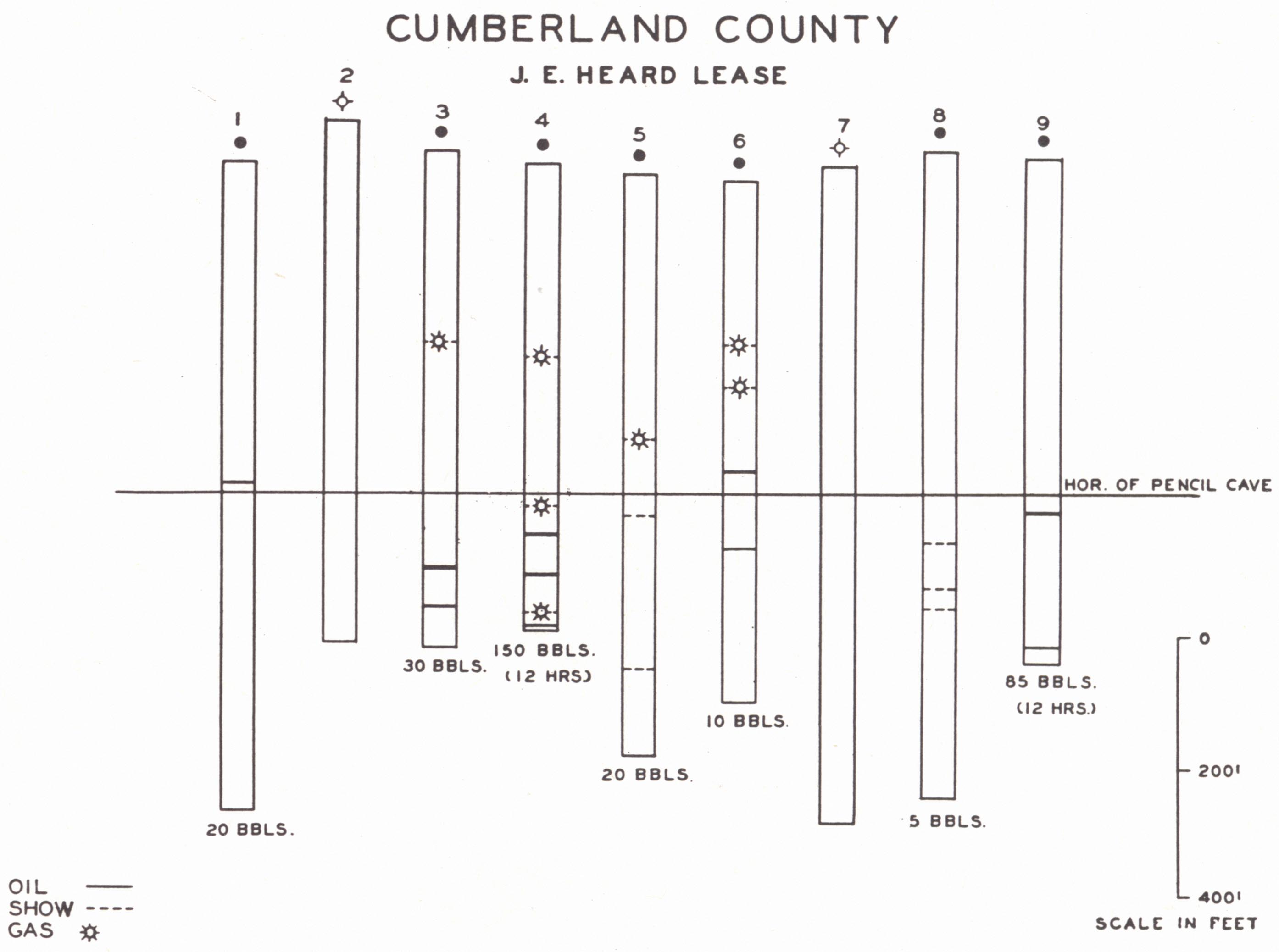 |
|
FIG. 37. Plotted section showing irregular
distribution of pay zones in |
The oldest formation in outcrop is the Leipers (Fairview), which is separated from the Chattanooga shale by five to 15 feet of grey to greenish grey, earthy, often dolomitic limestone with but few fossils. This is the Cumberland River "sandstone" of Shaler (1877) and has been regarded as Richmond, but the author is inclined to regard it as probably Tate. Oil has been encountered in rocks ranging from the Catheys to Knox. Two horizons are particularly useful in subsurface work. The "Pencil Cave" (or second Pencil Cave) is a green, bentonitic shale about 10 feet below the base of the Trenton (Hermitage). It is consistently present and takes its name from the tendency to break into fragments, which mark like a slate pencil, and to cave when wet. At the base of the Trenton (Hermitage) is the "Mud Cave" (or First Pencil Cave), a similar bentonitic shale.
The "Saint Peter sandstone" has been "recognized" in many drill records, old and new, and the term has been applied to any sandy horizon in the limestone succession 500 feet or more below the Pencil Cave. The thickness seldom exceeds five feet. According to Born and Burwell (1939a), the amount of sand is seldom more than five per cent of the rock, occasionally, though, as much as 25 per cent. Their stratigraphic studies showed these sandy streaks to be in the upper Knox dolomite (Canadian); that they are lenticular streaks that do not appear to occupy a definite stratigraphic position; and that the Saint Peter sandstone, as such, is not present in the section.
Producing zones are shown in the accompanying chart (fig. 36). It is believed that much of the porosity of these Ordovician limestones has been the result of fracturing and jointing enlarged by later solution. The same authors recognized that proximity of some of the pays to unconformities is significant. Jointing is better developed in certain beds, and also on the sharper flexures or portions of flexures. The authors found difficulty in accepting the Chattanooga shale as the source rock. Extensive lateral migration is precluded by the irregular distribution of porosity. They suggested the source rock to be that of the local Ordovician section.
SECTION H--BIG LIME PRODUCTION OF OWSLEY COUNTY
Buffalo Creek Pool (southeastern Owsley County).—The Buffalo Creek pool is a small oil pool producing from near the top of the Big Lime. The first commercial well was completed in 1924 with 20 to 25 barrels flush at 1,111 feet (Jillson, 1926). The pool consists of four producers in an area of about 12 acres. Production to the end of 1936 totaled 27,000 plus barrels. It occupies the northwestern flank of an anticlinal nose.
Island Creek Pool.—The Island Creek pool is a small abandoned oil and gas pool of about 20 acres in southwestern Owsley County, which has produced about 10,000 barrels of oil. Production is from the Big Lime and has included some flashy initial yield. An early gas well, the Harve Price No. 11, showed an initial open flow of 1¼ M in 1918. Hunter (et al., 1937) listed the "sand" as cavernous and the structure as monoclinal.
SECTION I-PRODUCTION OF THE PAINT CREEK UPLIFT22
 |
|
* Jillson (1937). |
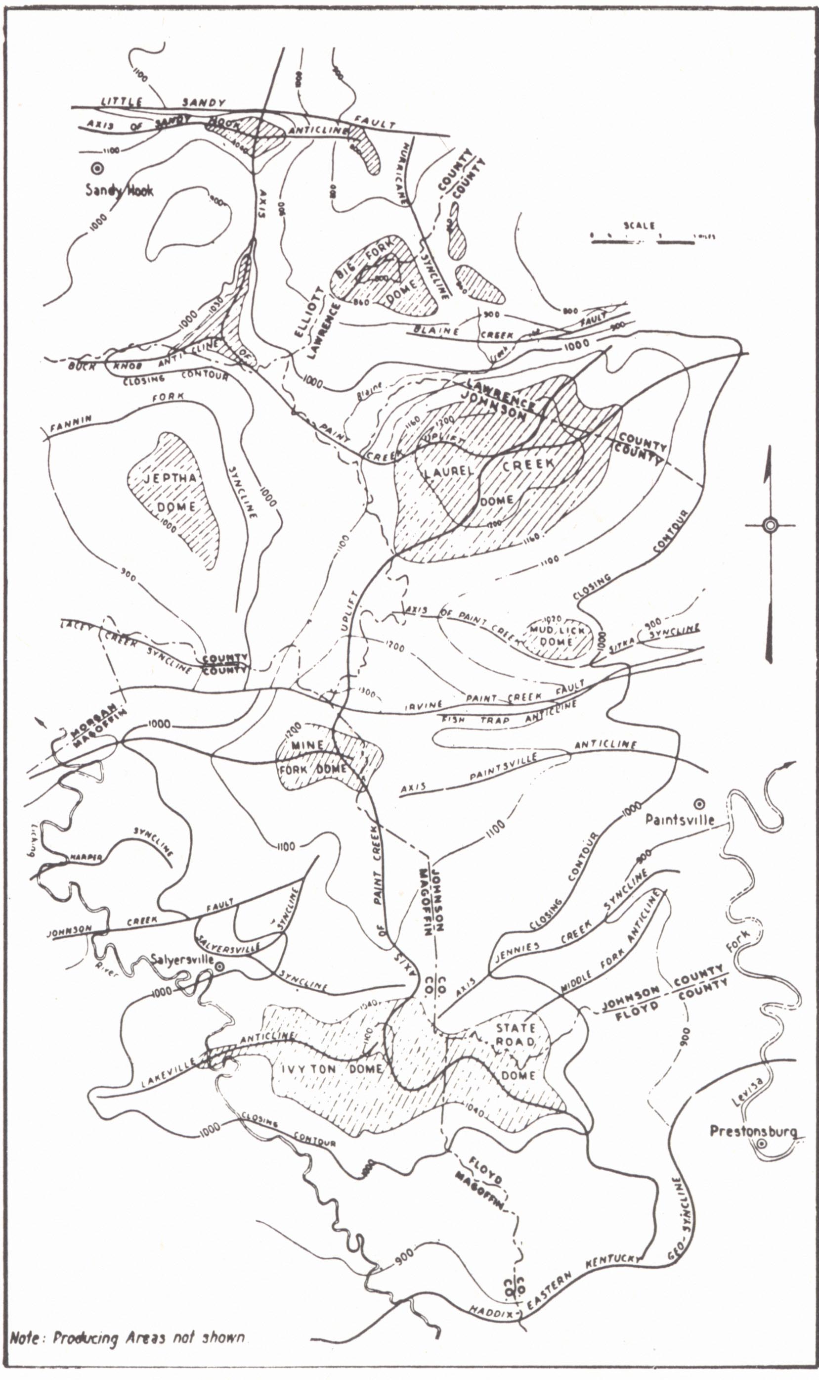
The producing area of the Paint Creek uplift ranks second in eastern Kentucky only to the Big Sinking-Irvine field in oil production and is an important producer of gas as well. This large anticline was recognized and referred to by Crandall as the "Conglomerate uplift," and named the Paint Creek uplift by Hoeing (l913b). The recurrence of the "conglomerate" in outcrop gives a local development of characteristic conglomerate topography in the valley bottoms. It is a large upwarp with north-south major axis and a closed reversal of about 250 feet (pl. XXXII) associated with the eastward termination of the Irvine-Paint Creek fault zone and associated folds.
| Plate CIII |
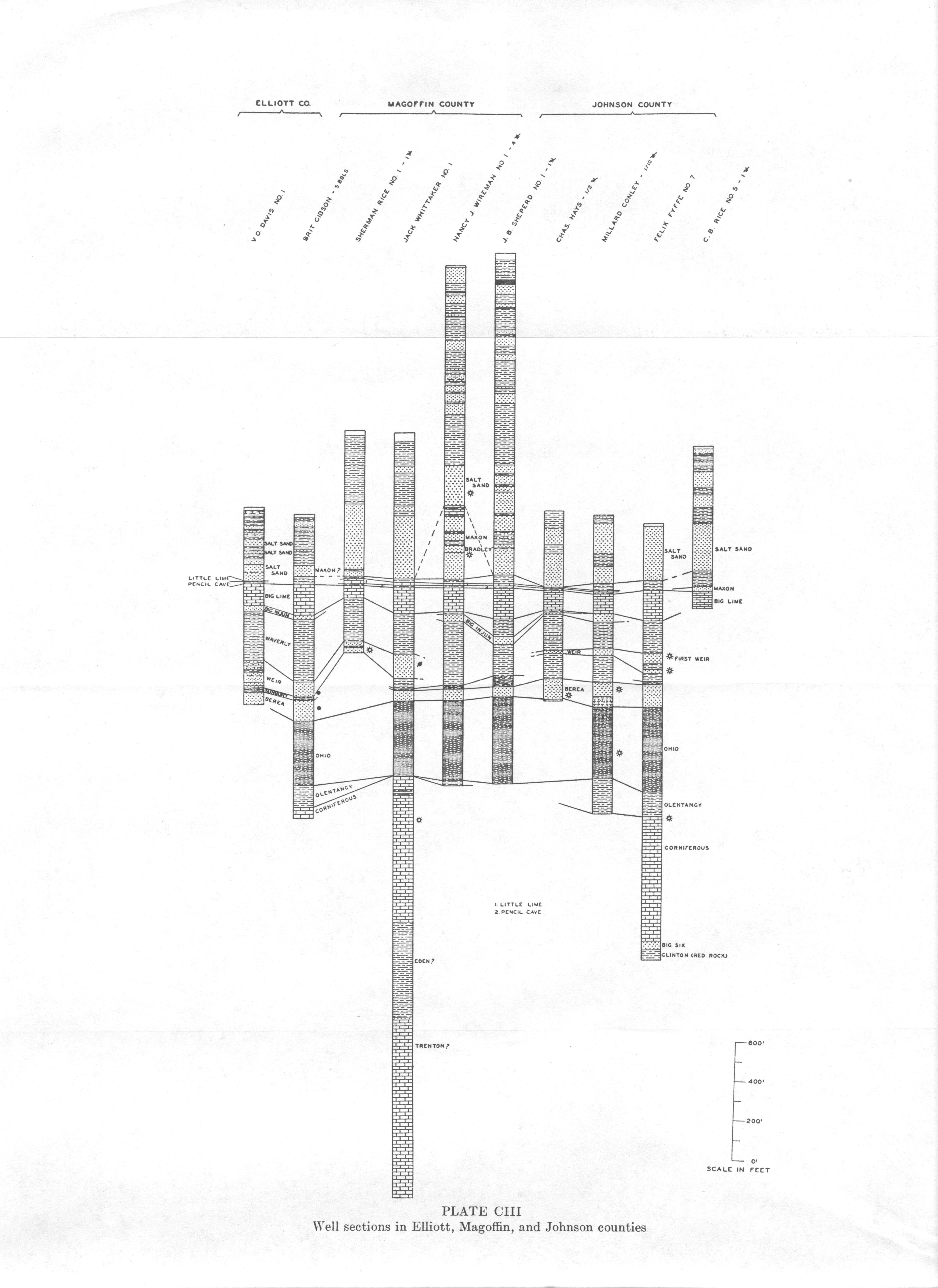 |
| Well sections in Elliott,
Magoffin, and Johnson counties |
Active development began in 1918 and 1919 and resulted in the establishment of the Weir sand as a major commercial producer. Gas wells ranged from 0.5 to 2 M feet open flow and averaged a rock pressure of 380 pounds. To the east on the structure the Wier sand develops shaly partings and becomes nonproductive.
Though an excellent example of anticlinal oil and gas, the field shows considerable divergence from the structure other than that due to local change in lithology of the pay. That the structure was involved in more than one period of folding was first recognized by Hoeing (1913c), and later by Jillson (1921), who called attention among other things to a decrease in interval between the Fire Clay coal and the top of the Big Lime as the crest of the structure was approached. A subsurface closure greater than surface closure is indicated.
Browning (unpublished) has studied the subsurface structure involving this convergence. Structure contoured on the Wier does not explain the distribution of production much better than that drawn on the Fire Clay coal. He has made an important contribution to the understanding of this field by redrawing the structure keyed on the Wier sand on the basis of the structure at the time of deposition of the Fire Clay coal. This earlier structure does not conform in many details with that drawn on the Fire Clay coal. The significant feature is that production conforms better to the pre-Fire Clay coal structure than to the later structure. Obviously distribution of oil and gas was already accomplished at this early date and later migration has not been great.
The lack of production on the northwestern flank of the Mine Fork dome has been interpreted by the same worker as a matter of loss by seepage along the Irvine-Paint Creek fault. Oil seeps are known.
Although the Wier has been the main producer, other sands have contributed. In the southern part of the Ivyton-Licking-Mine Fork area the Salt Sands are locally productive, along with the Black shale, Maxon, Big Injun, and Corniferous. In the northern end of the field about 5 per cent of the gas comes from the Black shale, Big Lime, Berea, and Corniferous.
| PLATE CIV | |
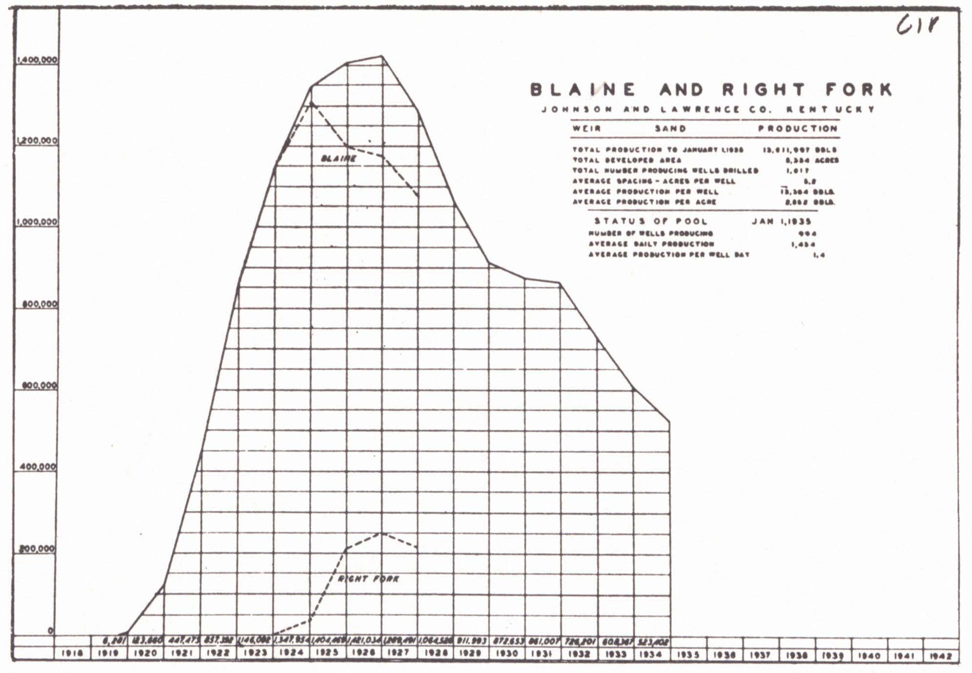 |
 |
| FIG. 1. Production chart,
Blaine and Right Fork pools, Johnson and Lawrence counties, Weir sand (Kentucky Oil and Gas Association, 1935). |
|
 |
|
| FIG. 2. Production chart, Oil
Springs, etc., pool, Magoffin County, Weir production (ibid.). |
FIG. 3. Structure of the Paint
Creek uplift (Jillson, 1928f, after Hudnall and Browning, 1924e). |
In recent work (unpublished manuscript, 1941) Thomas has indicated that Corniferous gas of the Mine Fork dome of Magoffin and Johnson counties and of the Flatgap dome (Laurel Creek dome) of Johnson County was associated with isopach lows on the Corniferous. He found that porosity, and thus available reservoir, was restricted to a limited area in the immediate vicinity of these lows. The situation was interpreted as indicating progressive development of the structure during Corniferous time.
| PLATE CV | |
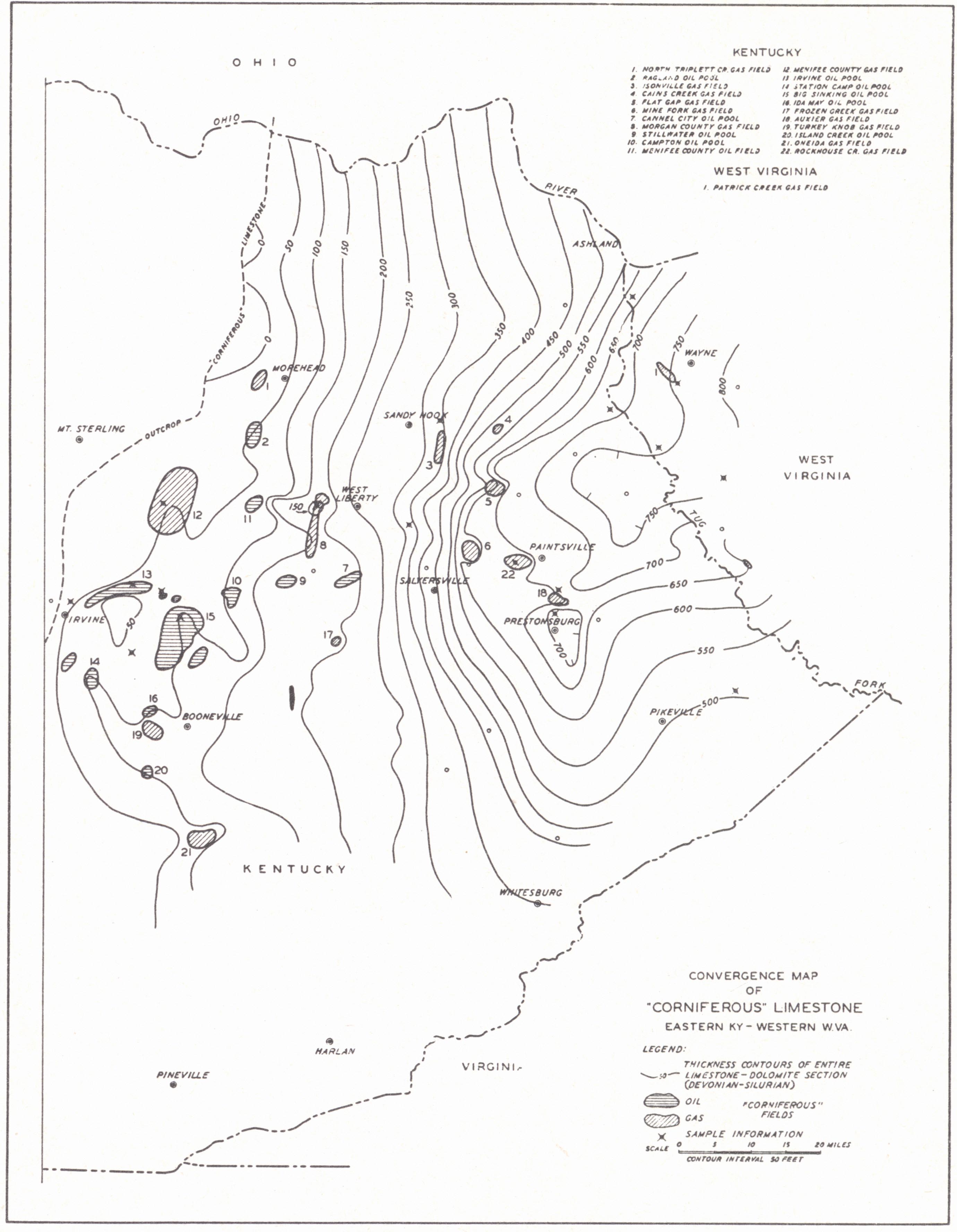 |
Isopach Map of "Corniforous" limestone
The "Corniferous" basin or lagoon indicated seems to be significant in explaining the distribution of Big Six production at the base of the" Corniferous". While these pools occur on the Paint Creek uplift which isolates the Pittsburgh Basin from its extension to the southeast, equally significant is their occurrence along the zone of an old hinge line indicated by the belt of rapidly thickening "Corniferous". The authors recognized that "major positive structural features such as the Irvine-Paint Creek and Warfield uplifts apparently were developing during this period but numerous minor anticlinal features now present in this area are evidently of more recent origin." The Big Six here attains a thickness of 50 feet and it is along this same hinge that the Weir and the Berea sands are best developed and productive. The Black Shale gas field (pl. LXXXII) follows the bottom and southern flank of the basin. The bottom is about 25 miles south of the lowest part of the Pittsburgh Basin in Kentucky. The early structural condition indicated in this part of the Pittsburgh Basin is in contrast to that shown for this area for the Pennsylvanian period by the formations of that system (see p. 137). |
At one time an important gas producer, the field is now well on its way to
depletion. This is true also for oil, though the life is being materially
extended by repressuring. Jillson (I937) listed maximum original production and
rock pressure as Redbush 1 M, R.P. 205 pounds, and Ivyton 2½ M, R. P. 340 per
well. A number of wells in the Win, Redbush, and Newcombe pools have encountered
sulphur gas in the Corniferous.
| PRODUCTION DATA THROUGH 1939 From C. D. Hunter et al., 1940 |
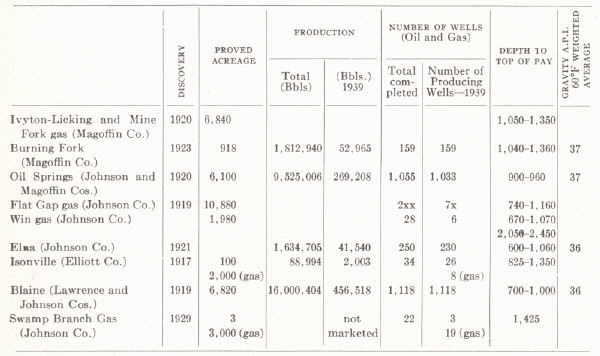 |
Paintsville Gas Field.23—A recent development with gas from the Big Six a few miles west of Paintsville in Johnson County and extending into Floyd County. It is high on the Paint Creek uplift. There are 12 wells (April 1942), 11 producing from the Big Six and one from the basal Corniferous 10 to 15 feet above the contact. The sand occurs 600 feet below the Black shale and ranges up to 50 feet thick. It is calcareous with 30 to 70 percent calcium carbonate. Quartz grains range up to 4 mm in size. The larger wells produce 0.5 M. Depth to the pay is 2200 to 2500 feet. Available porosity and permeability is regarded as the controlling factor.
A little gas from the same pay has been produced in the Win gas field located along the Johnson-Magoffin county line.
SECTION J—GAS FIELDS OF FLOYD, PIKE, KNOTT, AND MARTIN COUNTIES
This is the great region of shale gas production involving a large part of Floyd, western Pike, and northern Knott counties. Other pays include the Salt Sand, Maxon, Big Lime, and Big Injun. Relative importance of these sands in terms of percentage of the total production is given by Hunter and Browning (1935a):
| Plate CVI |
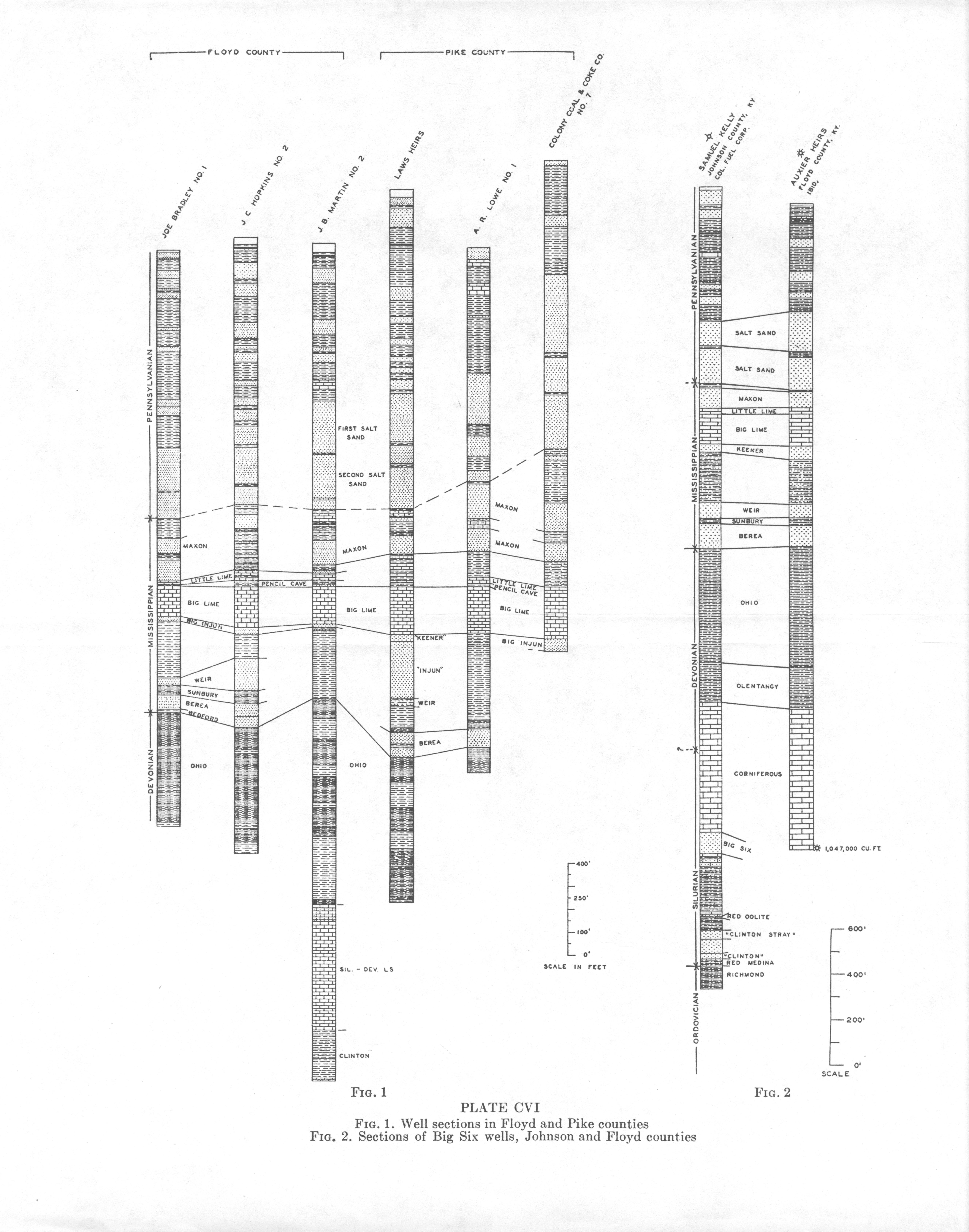 |
| FIG. 1. Well sections in
Floyd and Pike counties FIG. 2. Sections of Big Six wells, Johnson and Floyd counties |
|
Floyd |
Pike |
Knott |
|
|
% |
% |
% |
|
| Salt Sand |
9.2+ |
1.5+ | 3.5 |
| Maxon | 13.7+ | 9.6+ | 9.0 |
| Big Lime, Big Injun | 7.0- | 6.7+ | 8.0 |
| Black shale | 69.0- | 82.1+ | 79.0 |
| Big Six |
(a more recent development) |
||
Success in the exploiting of shale gas has come with the use of gelatin instead of nitro-glycerin. The whole 400- to 550-foot section of shale is shot with 5000 to 6000 pounds of this explosive. Few of the wells are natural producers. Production on a large scale dates back to about 1918 with production at that time mainly from the Maxon. Some gas was used for carbon black. In the past decade shale gas has become outstanding and most discoveries in the higher pays have been made incidental to drilling for the shale. According to Hunter, et al. (1936), structural relationships include almost any type and in most cases production shows no relationship to minor folds.
Structurally the field occurs rather low on the eastern flank of the Eastern Kentucky geosyncline, occupying much of the anticlinal nose (Paint Creek uplift as shown in surface structure) extending northwest and separating that geosyncline from the main body of the Pittsburgh Basin in Martin, Lawrence, etc., counties. This may have some bearing on the location of the field. The situation is somewhat complicated structurally in that the geosyncline is not reflected in structure drawn on the Black shale and whereas the surface rocks show a northwest regional dip the Black shale dips off to the southeast. The development of this structural relationship is discussed on page 137. In so far as the Mississippian pays are concerned the structure must be intermediate and further complicated by the progressive development of the Paint Creek uplift. The Black shale as a reservoir has been discussed on page 293. In so far as the Salt, Maxon, and Big Injun sands are concerned, large structure in connection with lenticular nature of the pay would seem to control occurrence of production.
Some oil is produced locally from the Maxon and Big Lime. This includes the Beaver Creek pool (northeastern Knott and southwestern Floyd counties) and the Betsy Layne pool of central Floyd County. Subsurface structure on top of the Big lime in Floyd County shows many minor irregularities, but production shows little relationship to them.
Martin County Gas Field.—Although production of gas from the shale is dominant in Floyd and Pike counties, in Martin County other pays, including the Maxon, Salt Sand, Big lime, and Big Injun, are relatively more important. Relative importance is given by Hunter and Browning (1935a).
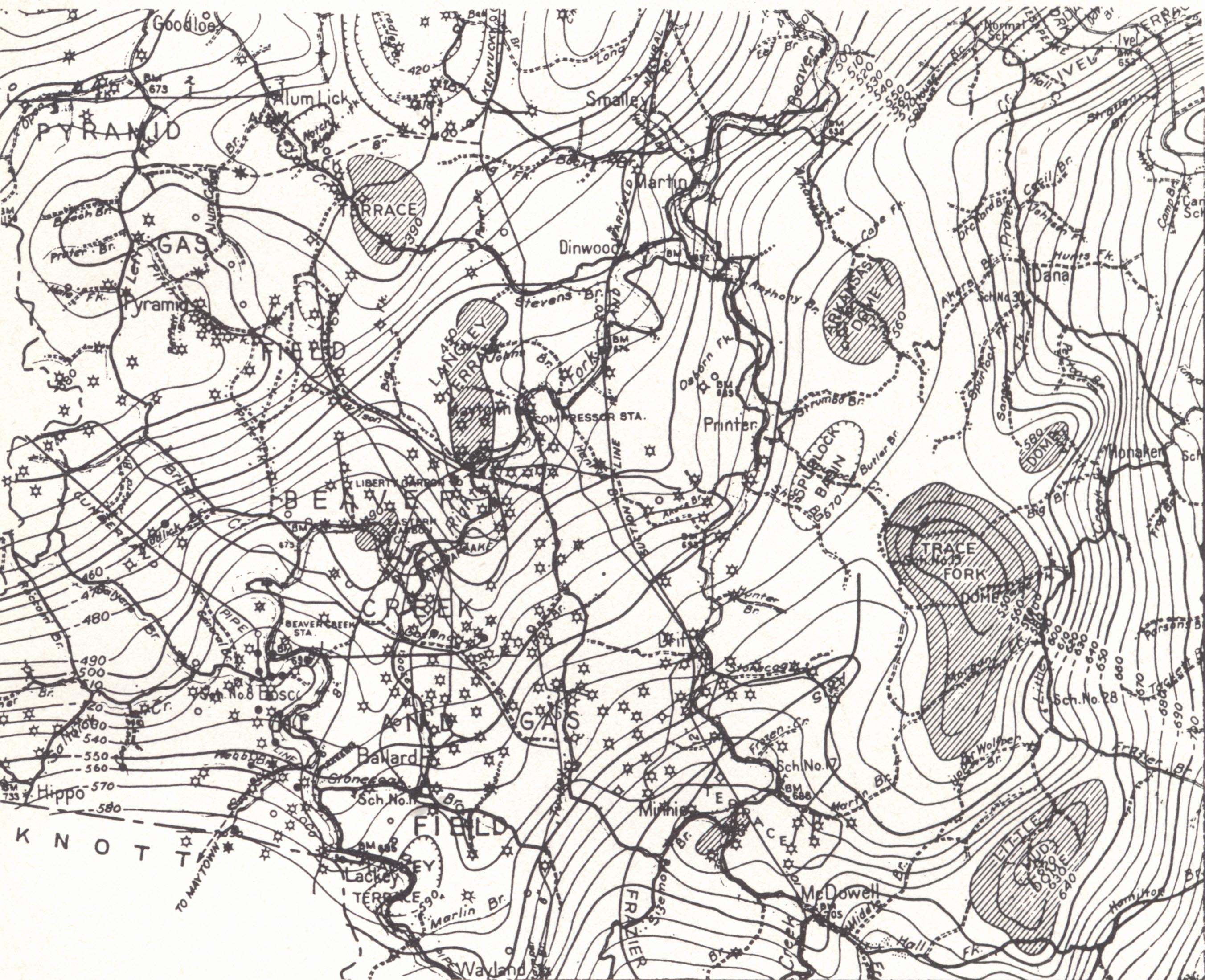 |
| FIG. 38. Subsurface structure
of part of Floyd County (Beaver Creek oil and gas field) contoured on the top of the Big Lime (Miller and Withers, 1928) |
| No. of Wells | ||
| Salt Sand | 19% | (A little from the Berea according to Jillson (1922)) |
| Maxon | 28 | |
| Big Lime-Big Injun | 19 | |
| Black shale | 34 |
The first well was drilled in 1881. Carbon black was manufactured from 1891 to
1901, when the field was connected by pipeline with Ashland, Catlettsburg, and
Ironton and vicinity. In 1912 gas was piped to central Kentucky, replacing the
rapidly declining supply of Menifee County gas. In 1936 there were 225 producers
(Jillson, 1937), about 35 abandoned wells, and some new drilling wells. Wells
ranged up to about 6 M maximum with rock pressure about 400 pounds in the Maxon,
Big Injun, and Wier and 525 pounds in the shale. Maxon and Big Lime production
is spotted. Gas encountered in the Corniferous is sour. Wells in the Salt Sand
and Maxon had lives of 10 to 12 years (Jillson, 1937). Those in the Big Lime
declined more rapidly. The field continues across Tug Fork of Big Sandy into
West Virginia.
| PLATE CVII | |
 |
 |
| FIG. 1. Structure map (surface) of a part of Martin County. Contoured on top of Fire Clay coal (Hudnall, 1923a). | FIG. 2. Subsurface structure map of same area in figure 1. Contoured on the top of the Big Lime (Hudnall, 1924d). |
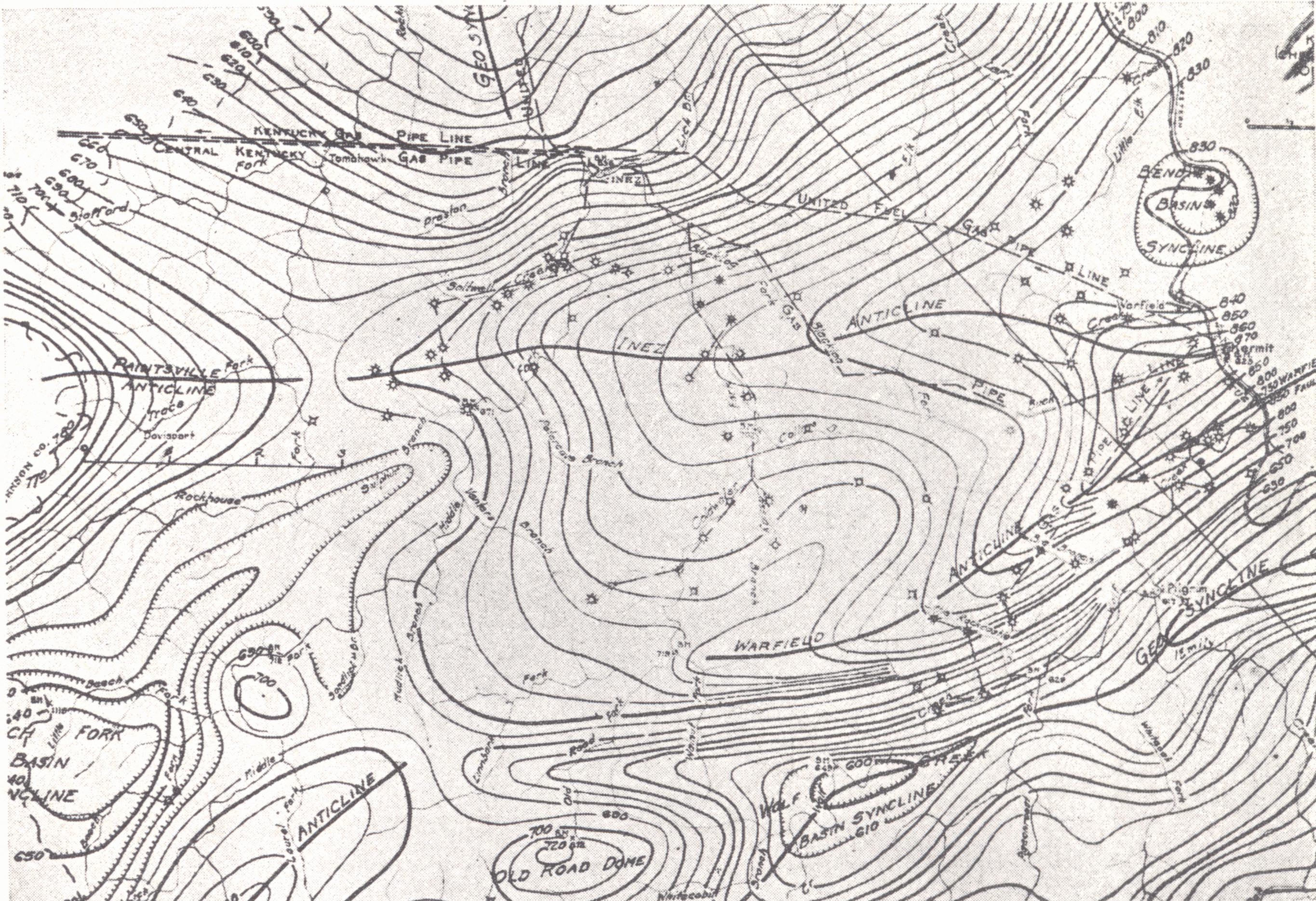
Structure as determined on both the Fire Clay coal (surface) and top of the Big
Lime (Hudnall, 1923d, 1924c) shows production to be anticlinal. Structure
determined on the former shows a large anticline formed by the convergence of
the Warfield and Inez (Irvine-Paint Creek axis) anticlines. Structure on the
latter is somewhat similar, but the Warfield axis is only a terrace and
anticlinal nose on the southern flank of the Inez anticline.
| PRODUCTION DATA THROUGH 1939 From C. D. Hunter et al., 1940 |
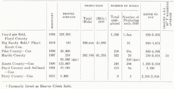 |
The Canada field in north central Pike County in the region between Pond Creek and Big Creek has a large number of gas wells along the D'Invilliers anticline. The main producing zone is the Maxon, some comes from the Black shale and minor amounts from the Big Lime and Salt Sand. There are 40 feet of closure on the Maxon (Jillson, 1937) covering an area of about 12 square miles. Maximum open flow recorded was 1¾ M and original rock pressure was 560 pounds. The peak of production reached in 1935-36 was about 6 M feet (Jillson, 1937).
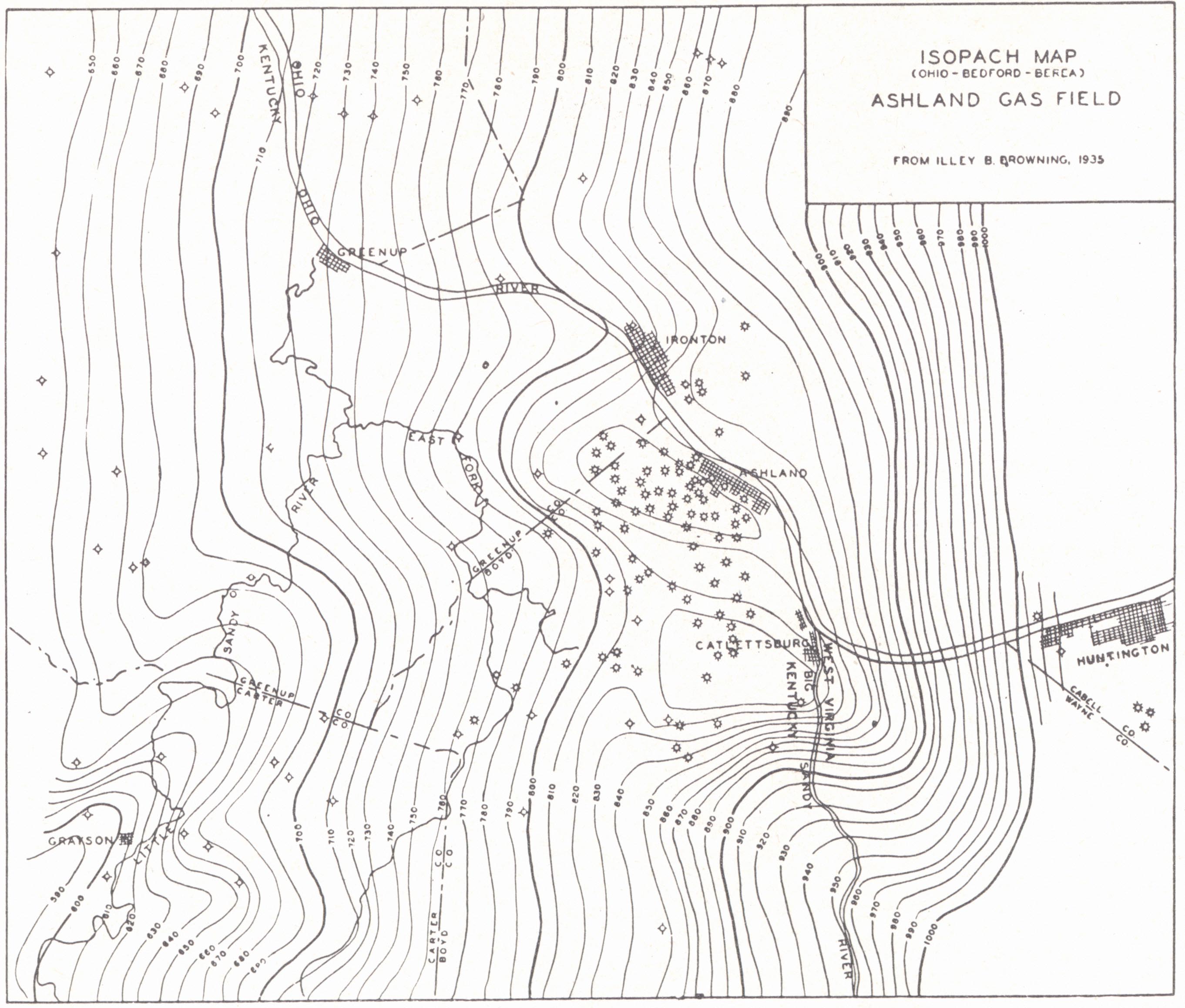
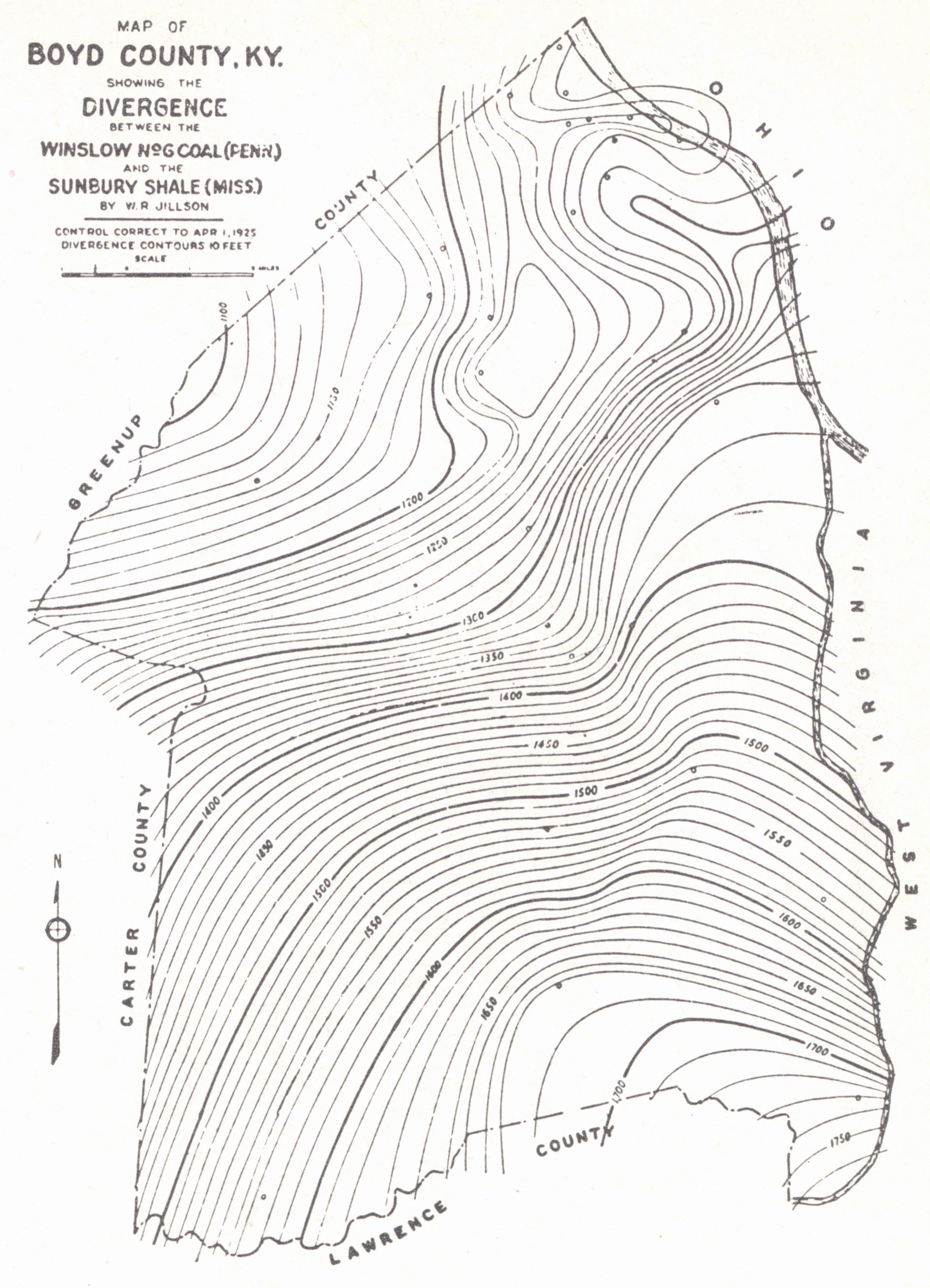
SECTION K—BOYD COUNTY GAS FIELD
The first wells were drilled in the Boyd County field during 1880-1890, and gas was discovered in the Black shale between 1895 and 1900. Jillson (1937) listed a total of 216 drilled wells (including dry holes) and one¬-fourth to one-third of them were within the city limits of Ashland. The field lies within an outlying 60 per cent isocarb. Production is mainly from the Black shale and a part from the Gordon sand, lenticular sandstone bodies within the shale, which produce wells of large open flow. Nowhere else in Kentucky are these productive sand lenses known. The larger part of the shale production, however, is of the type found in Floyd County and vicinity. In addition, gas is produced from the Salt Sand, Big Injun, and Corniferous, and a little oil has been found in the Berea. Production in the shallow sands has proved short lived.
| PLATE CVIII |
 |
| Well sections in Boyd,
Lawrence and Martin counties |
Geologic structure drawn on the Fire Clay coal (Hudnall, 1924) showed a monocline interrupted by a number of small domes. Subsurface structure on the top of the Sunbury (Jillson, 1925a) reduced these to minor irregularities.
Browning (1935) presented an interesting interpretation of the Gordon sands. As shown in plate CIX, figure 1, production is found in areas of isopach low of the shale. These are interpreted as shallows or terraces on the sea floor. Here sediment was within the zone of active wave agitation and the finer material was removed to deeper water, where the greater thickness of shale accumulated.
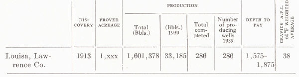
SECTION L—BEREA PRODUCTION FROM THE LOUISA (BUSSEYVILLE AND FALLSBURG) POOLS, LAWRENCE COUNTY
Production of oil from the Berea began about 1912. The wells are not large but are long lived. Starting at eight to 10 barrels they drop off to four or five at the end of the first month and hold up well thereafter.
Structural relationships are shown in figure 39 (structure drawn on the Sunbury
shale). Production around Busseyville occupies the southern flank of a syncline
cut off up the dip by the Wallridge fault. In the vicinity of Louisa and
Fallsburg it extends around the face of an anticlinal nose. The Sunbury shale
directly overlies the Berea, hence reflects the structure of the pay with
accuracy.
| PRODUCTION DATA THROUGH 1939 From C. D. Hunter et al., 1940 |
 |
| PLATE CIX | |
 |
 |
| FIG. 1. Isopach map
(Ohio-Bedford-Berea interval), Ashland gas field (Browning, 1935) |
FIG. 2. Map of Boyd County showing divergence of the Winslow (No.6) coal and the Sunbury shale (Jillson, 1928f) |
 |
|
FIG. 39. Subsurface structure of part of
|
Footnotes
1 Miller, 1919; Jillson, 1919.
2 Freeman (1939a) regarded the lower 40 typically St. Peter. The upper part is
fine grained and calcareous and possibly Stones River.
3 See figure 36, page 353 for other Trenton pays.
4 Gas does occur, though, low in the Corniferous 500 and 600 feet below the
shale in the Mine Fork (Magoffin County), Flat Gap (Johnson County), and Auxier
(Floyd County) fields as well as in the Big Six near Prestonsburg.
5 Paper read before the Appalachian Geological Society, November 8, 1935.
6 From a symposium prepared by the Appalachian Geological Society, 1935.
7 The situation seems to be somewhat like that involved in the distribution of
upper Corniferous production and that of the Big Six and is outlined in a paper
presented before the meeting of the American Association of Petroleum
Geologists, April, 1942, at Denver, Colorado, by R. C. Lafferty and R. N.
Thomas. (See plate CV and notes on pp. 358.)
8 These notes taken from L. B. Freeman, 1938.
9 Some "Corniferous" gas has been found in the Isonville (southern Elliott
County), Flat Gap (northern Johnson County), Mine Fork (northeastern Magoffin
County), and Auxier (northern Floyd County) fields. These are all in the region
of the Paint Creek uplift and are mentioned in connection with Weir sand
production of that region (p. 355).
10 A. M. Miller, 1919, gives the discovery well as on the farm of Uncle Tommy
Ragland.
11 See Irvine-Big Sinking group.
12 These notes are from a study of this field by Phil M. Miles (Master's thesis,
University of Kentucky, 1939) based on data supplied by the Petroleum
Exploration Company of Lexington through the courtesy of Earl Wallace.
13 Structural relationships are summarized in a diagrammatic cross section (Pl.
XXXIII, after Freeman, 1941).
14 As defined by that author.
15 Miller (1919) said only the Beechwood member of the Sellersburg, and this is
confirmed by Savage (1930a).
16 Miller (1919) said up to 60 feet of Osgood to Louisville.
17 Notes mainly from Russell (1934).
18 Notes from Russell, 1934.
19 Notes from Russell, 1934.
20 Sunnybrook production is considered separately with the Burkesville field.
21 The recent report by Kendall Born and H. B. Burwell (1939) on Clay County,
Tennessee is the first comprehensive published work on this field and becomes
the outstanding reference work. His conclusions are equally applicable to
Cumberland, Clinton, and Monroe counties, Kentucky.
22 Mainly Weir sand (Johnson, Lawrence, Magoffin, and Elliott counties).
23 Notes supplied by George Straughan.
24 Now commonly spelled Barlow in referring to the sand.
25 Notes from E. A. Barnes.
26 Notes from E. A. Barnes.
27 Notes from E. A. Barnes.
28 Notes from E. A. Barnes.
29 Notes from E. A. Barnes.
30 Notes from R. C. Lafferty.
31 Notes from R. E. Stouder.
32 These notes from information supplied by D. J. Jones.