FIG. 2. (right) Well sections Birk City pool, Henderson County.
Sections
A. Introduction
B. Pays
C. Corniferous production
D. Big Six gas field
E. Knox-Whitley counties pools
F. Wayne County field
G. Cumberland River field
H. Big Lime production of Owsley County
I. Production of the Paint Creek uplift
J. Gas fields of Floyd, Pike, Knott, and Martin counties
K. Boyd County gas field
L. Berea production of Lawrence County
M. Owensboro field
N. Miscellaneous small oil and gas pools of western Kentucky
O. Gas pools of Meade and Breckinridge counties
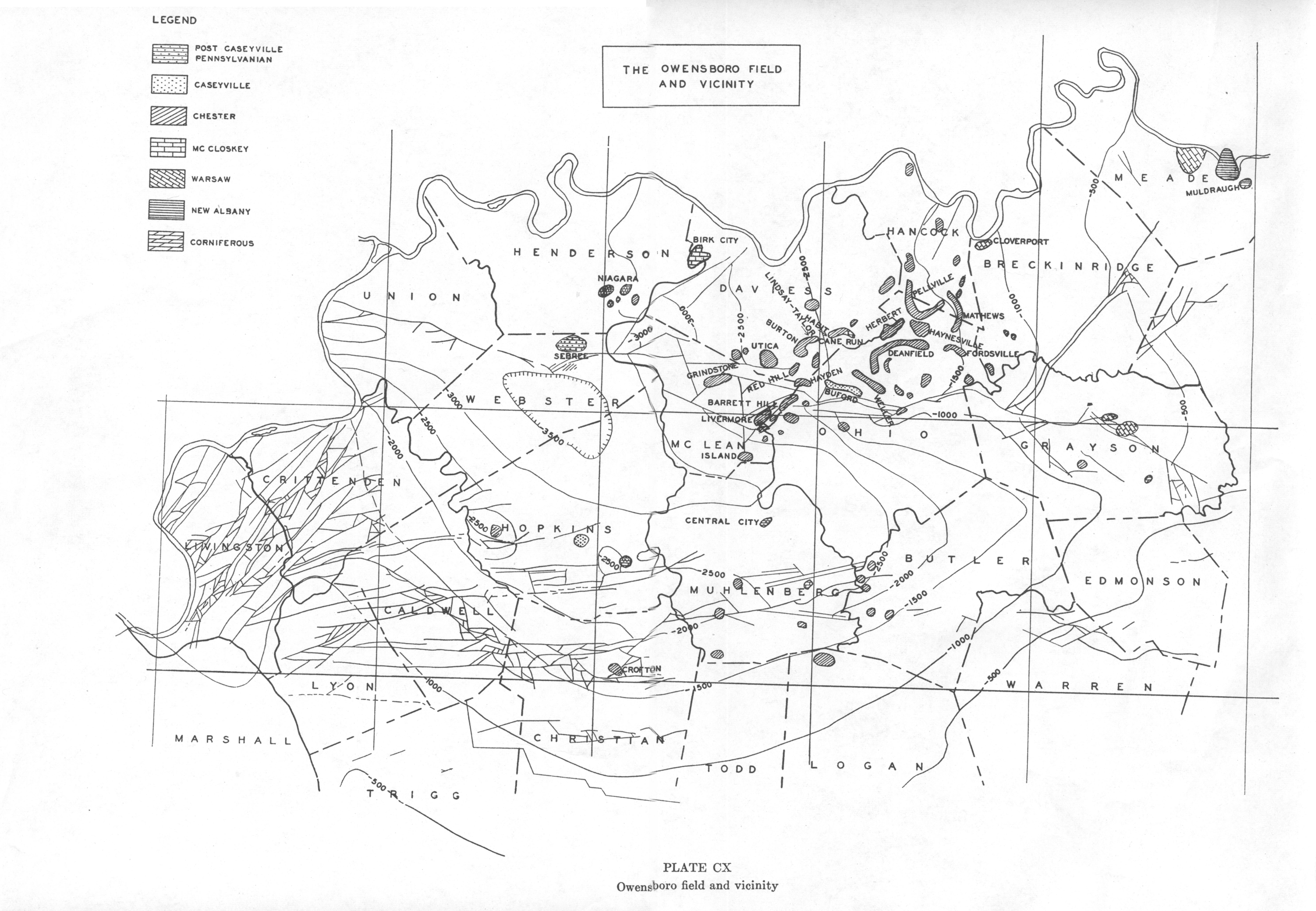
SECTION M—OWENSBORO FIELD
| Plate CX | Plate CXI |
|
|
|
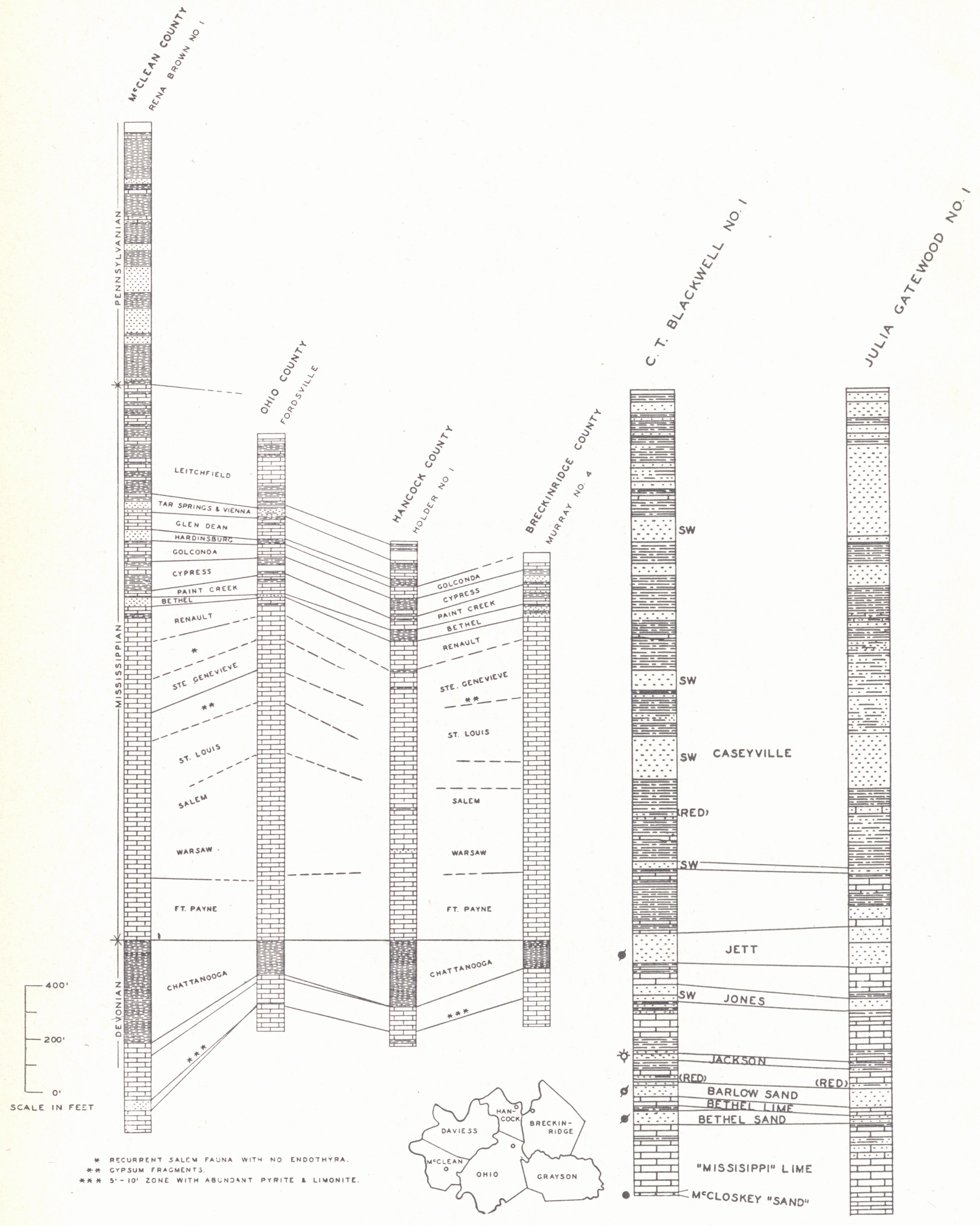
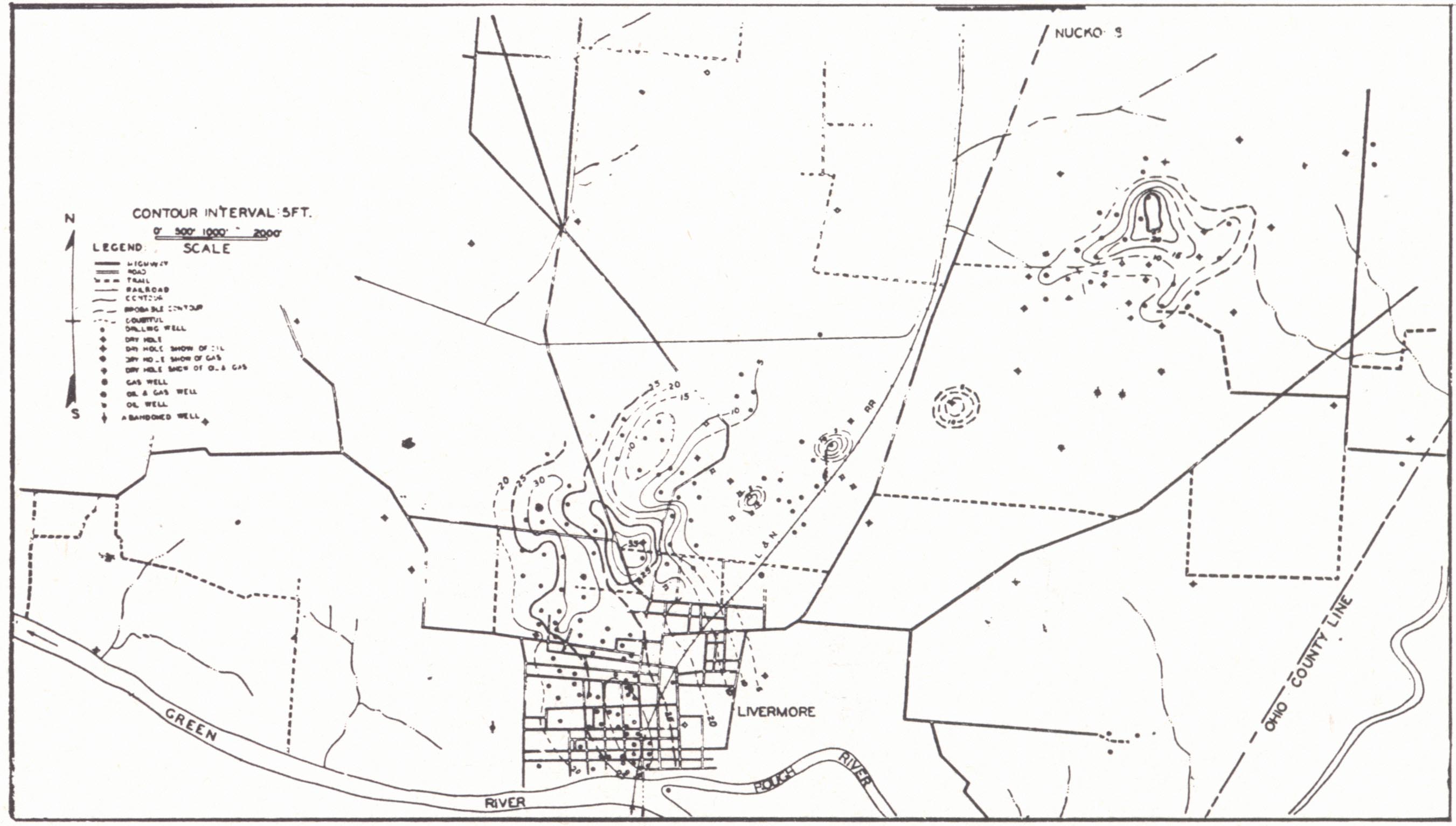
| Owensboro field and vicinity | FIG. 1. (left)
Stratigraphic sections from deep well records and samples, Owensboro field
(from sections and notes by L. B. Freeman). FIG. 2. (right) Well sections Birk City pool, Henderson County. |
Drilling operations date back to 1918-19. As a producer the field had its beginning in 1923 and for the past decade has been the main seat of petroleum activity in the state. It covers a considerable area in Daviess, Ohio, Hancock, McLean, and Henderson counties and includes a large number of pools of rather limited extent. It is a field in which lithology of the sand changes rapidly, and this has been the important factor, combined with local structure.
The field lies in the Western Coal Basin with regional dip south and west, interrupted by folding and faulting. The most pronounced disturbance is the Rough Creek fault zone which crosses the southern part of the field. Production occurs to the north and within this zone. Most of the outcropping rocks belong to the Carbondale formation. The Lead Creek and Providence limestones and the No. 9 and No. 11 coals have been particularly useful as key horizons in surface work.
| PLATE CXII Owensboro field |
|
 |
 |
| FIG. 1.
Structure map, Ambrose-Weller pool, Ohio County. Contoured on the top of the Vienna (Brown Lime) limestone (Shiarella, 1933). The occurrence of oil i s governed by the presence of the sand body rather than structure. |
FIG. 3. Structure map, Herbert pool, Ohio County. Contoured on top of Vienna (Brown Lime) limestone (Shiarella, 1933). In this and the Hayden pool, although the occurrence in each case is on an anticlinal nose, the extent of the sand body is more significant. |
 |
 |
| FIG. 2. Geologic diagram,
Buford pool, Ohio County (Shiarella, 1933). A buried pre-Pennsylvanian channel with local sand bars determines production. |
FIG. 4. Structure map, Hayden pool, Daviess County. Contoured on top of Vienna Limestone = Brown Lime (Shiarel1a, 1933). |
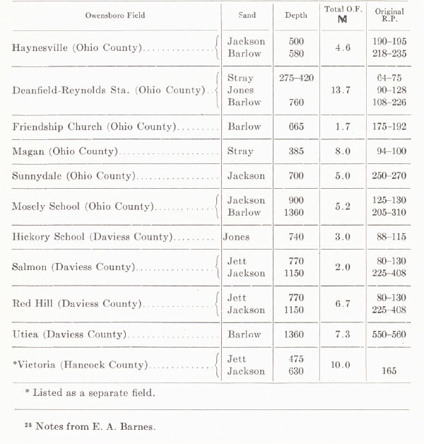
Production comes from the various sandstones (occasionally a limestone) of the Chester, and the Caseyville formation. More recently the McClosky (Ste. Genevieve) sand, which has been a big producer in Illinois, has assumed some importance as a result of the discovery of the Birk City pool of eastern Henderson County. Earlier small McCloskey wells had been drilled in Daviess County and near Greenville in Muhlenberg County. The Corniferous has produced in several small wells near Hartford, and one at Island in McLean County. Neither the Trenton nor St. Peter has been productive.
According to Russell (1932) and Shiarella (1933) the oil has apparently come from a source close to the producing sand bodies, and there has been little vertical (cross stratum) movement. It has been pointed out that gravity of the oil decreases with distance from the Rough Creek fault.
Ambrose-Weller Pool (plate CXII, fig. 1).—The Ambrose-Weller pool is near Taffy in Ohio County. The discovery well was drilled by the Ohio Oil Company on the Ellis and Heflin farm in 1926. It was completed at 667 feet in the Jett, and initial production was 50 barrels. Production came from a small outlying body a few hundred feet north of the main sand body. The latter was discovered shortly afterwards by the drilling of the Weller No. 1 by J. C. Ellis. Structure has little to do with production, which is encountered where sand conditions are good. The sand varies from 12 to 70 feet in thickness. Water occurs on the western side in those wells drilled to 210 feet minus. In this vicinity wells have a slower decline. Most of the wells drilled in 1927 and 1928 had initials of more than 100 barrels. The field in 1933 averaged about two barrels to the well (Shiarella, 1933).
Hayden Pool (Red Hill Pool, plate CXII, fig. 4), Daviess County. — The Hayden
pool was discovered by L. C. Young in 1928. The well was completed at 1019 feet
with 28 feet of pay in the Jett and an initial production of 100 barrels. The
average thickness of the pay is 14 feet, but varies from 2 to 22 feet. It is a
small pool, and accumulation occurs on a southwest-plunging anticline with salt
water down the dip (Shiarella, 1933).
| PLATE CXIII | |
 |
 |
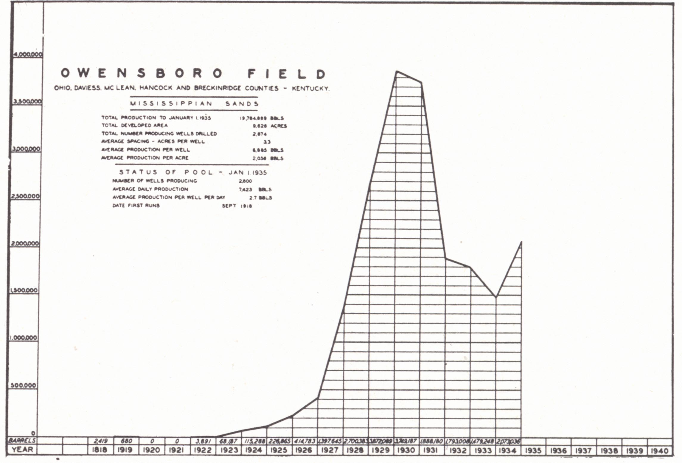
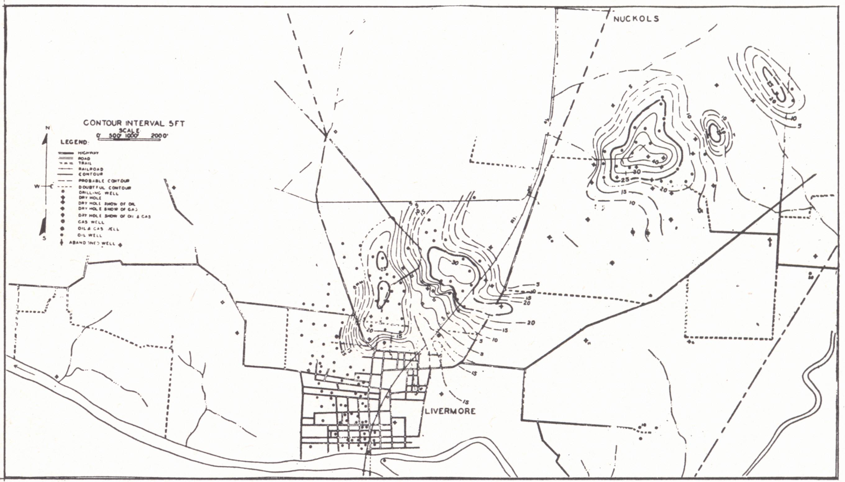
| FIG. 1. Production chart, Owensboro field (Kentucky Oil and Gas Association, 1935). | FIG. 2. Subsurface map of Livermore oil pool, McLean County. Contoured on base of Barlow Lime (Wesley, 1936). |
 |
 |
| FIG. 3. Isopach map of Barlow sand, Livermore pool, McLean County (ibid.). | FIG. 4. Isopach map of Bethel sand, Livermore pool. McLean County (ibid.). |
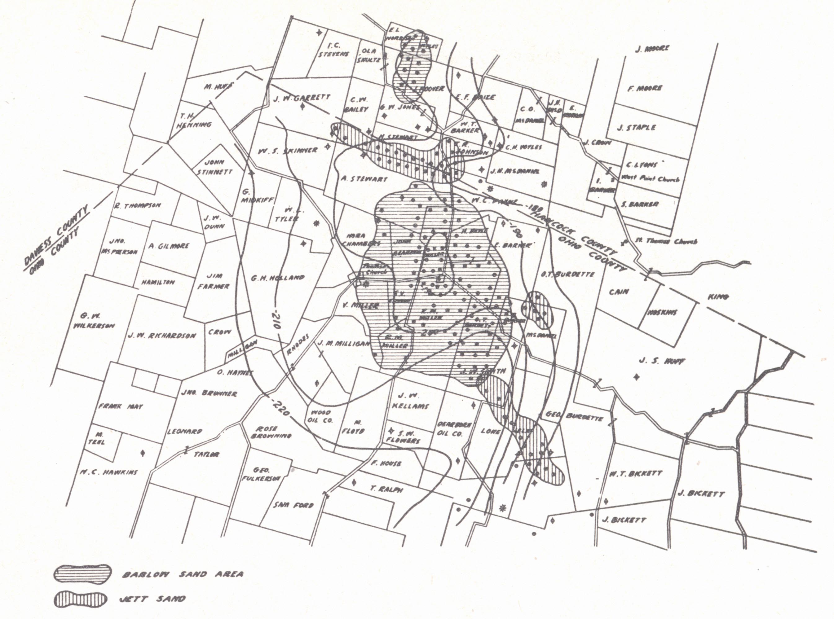
Herbert Pool (near the Herbert School in northern Ohio County near the Hancock County line plate CXII, fig. 3).—The first well in the Herbert pool was drilled in 1920 by Cy Johnston et al., on the Cole Jett farm and produced from the Jett at 446 to 476 feet. In 1921 the Barlowe24 No. 1 by Bert Thompson obtained production in the Barlow sand at 726 to 746 feet. Both pays have taken their names from these wells. Both wells lie north of the main pool which was opened in June, 1922. Most of the wells produce from the Barlow with initials of 30 to 75 barrels. Several produce from both pays. Jett wells were the greater producers, several giving 100 barrels flush. The Jett sand averages 20 to 30 feet thick, the Barlow about 15 feet. The latter, though, is the more uniform in character and of greater extent.
Barlow production is on a terrace on a south westward-plunging anticline and the Jett production is just to the southeast of this terrace. A little water has been encountered down the dip (Shiarella, 1933).
The producing area just to the north in southeastern Hancock County has gone under the name of the Pellville pool which was opened in 1922. Structure (maps by Jillson and Hudnall in Jillson, 1926) on the Jett sand show a westward-dipping anticlinal nose. As in the Herbert pool, the presence of the lenticular sand body seems to be the important thing.
Habit Pool (Habit, Daviess' County).—The discovery well in the Habit Pool was drilled in by the Johnson Oil and Refining Company on the Eaty farm in 1930 in the Fuqua Stray at 902 to 928 feet with an initial of 100 barrels.
"The producing sand is the Fuqua Stray (Waltersburg) and occurs in a channel cut into the "cavy muddy" blue shale that occupies the 50 feet between the Menard and Vienna limestones. The channel here has a width of more or less 1,200 feet. The sand has a thickness of from five to 44 feet with an average of 20 feet. The top is usually dark, shaly, and laminated, showing cross bedding. The bottom 20 feet is usually a fine-grained sand, and in the center of the producing streak is free from silt, and white in color. It is this streak that yields the best wells" (N. W. Shiarella, 1933).
Lindsay-Taylor Pool (near Masonville, Daviess County).—This is a small pool covering less than 15 acres. Its three wells produce from the Jones sand (Hardinsburg). The discovery well was the Taylor No. 2 drilled in at 1122 feet in 1929 with an initial of 120 barrels. The other two had initials of 30 barrels each. The sand is 40 feet thick and produces from the upper 12 feet. The lower part carries salt water. It is lenticular and grades into shale or limestone. Dry holes encountered shaly places (Shiarella, 1933). The structure, which seems to have little significance, is a northwestward-plunging anticline truncated by a fault.
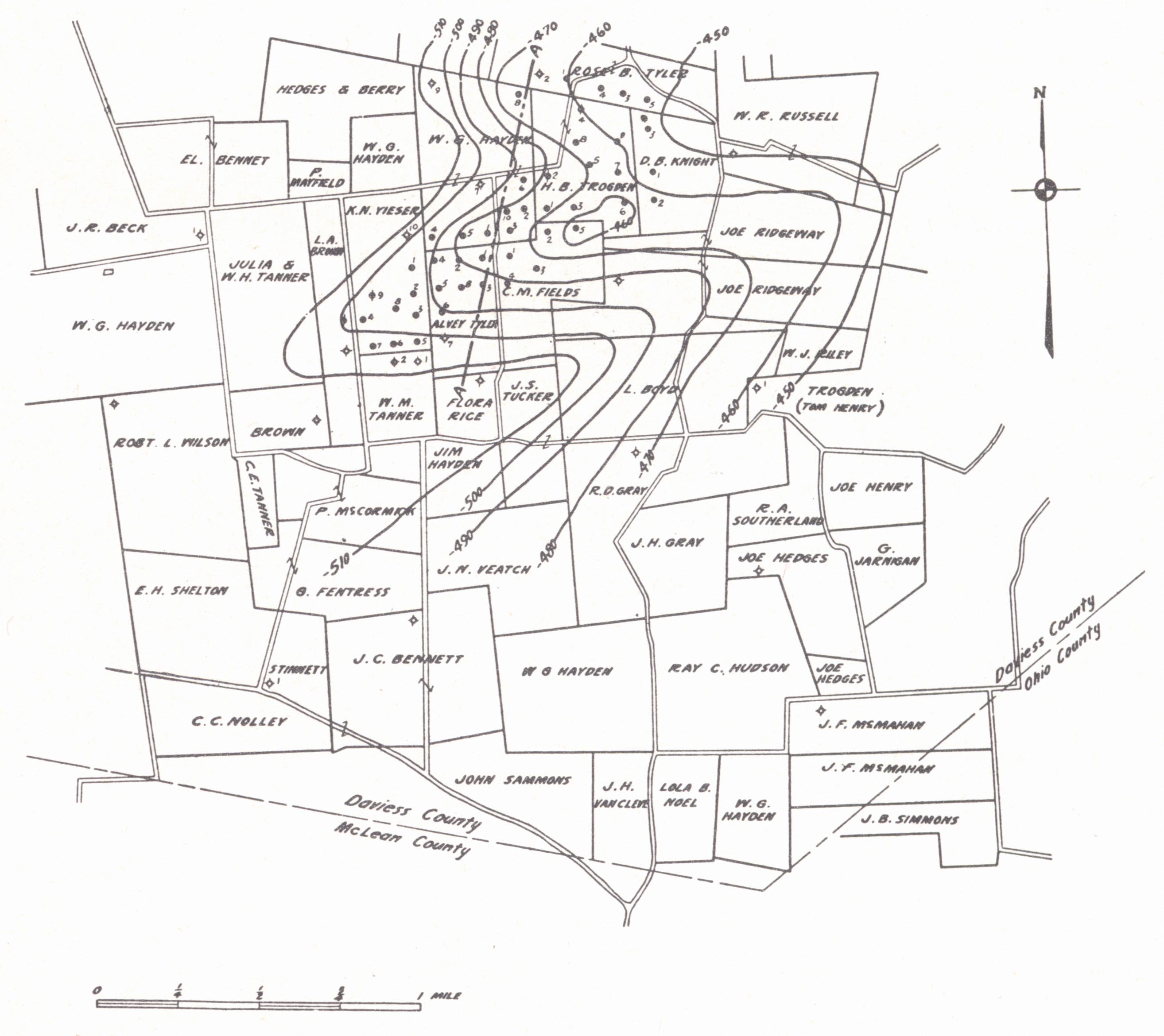
Utica Pool25 (south central Daviess County).—This important oil and gas pool was opened by the Creek Drilling Company with its Jim Brown No. 1 in 1928 from the Hardinsburg (Jones sand) at 1241 feet. Structural control is a dome with 100 feet of closure contoured on the Vienna limestone. In 1938 the pool was extended to the southwest by the drilling of 0. D. Vickers', et al., Ed Bennett No. 1 with initial production of 75 barrels per day, after acidizing, from the McCloskey at 1666 feet. The structure is a nose off the main anticline. Other sands of the Chester have also been productive. There are about 200 wells in the field.
Handyville Pool25 (eastern Daviess County).—Opened in February 1939 by the E. W. Richmond No. 1 of the Masters Oil Company. Production came from the Jett sand at 1177 feet with an initial of 98 barrels per day. Other sands of the Chester have also been productive. The main pay, the Jett, occurs as a sand lens on an anticlinal nose. There are about 50 producing wells.
Buford Pool (near Buford, Ohio County, plate CXII, fig. 2).—The discovery of a buried channel was indicated with the drilling of the J. S. Bartlett No. 1 in 1927. The well missed the usual succession of Chester limestones that occur above the Jett. Production was encountered in the summer of 1929 by the No. 1 on the Barnett Creek Church lot. The well was completed at 600 feet with 15 feet of sand and a production of 300 barrels flush. It is one of the richest pools in western Kentucky. Several wells made between 300 and 500 barrels initial and one made 1750 barrels. The sand is highly permeable and does not require shooting.
Production comes from Caseyville sand bars deposited in this old river channel carved into the Chester. The channel may be seen in outcrop in the Rough Creek uplift at the head of Halls Creek near Marvin Chapel in Ohio County. From here it meanders northwest toward the town of Buford and has been traced as far as Maxwell in Daviess County. Most of the pools in this channel show salt water (Shiarella, 1933).
Barrett Hill Pool (Ohio County).—The Barrett Hill pool produces from the Bethel, Barlow, and Jackson sands listed in order of importance, with minor production from the Fuqua, Jett, Brown Lime, and McCloskey. The structure is a faulted anticline forming a horst. Within this structure the lenticular nature of the sands determines distribution of production.
Livermore Pool (in and near the town of Livermore in northeastern McLean County, pl. CXIII, figs. 2, 3, and 4).—The discovery well in the Livermore pool was the Josh Ellenwood No. 1 drilled into the Bethel sand in 1935. Barlow production was discovered in the Ollie Givens No. 1 which was good for 20 barrels of oil and 1.3 M cubic feet of gas. The pool is located on the southern flank of the Rough Creek uplift. The structure is much like that of the Barrett Hill pool, an arched and much faulted (horst) structure. Production comes principally from the two sands mentioned with flush production up to several hundred barrels. As in other pools of the field stratigraphic traps are of first importance. Each sand lens is independent of others at the same horizon. Bethel and Barlow sand bodies have not coincided in position and wells have produced from one or the other. The Bethel is estimated as containing 18,000 barrels of oil per acre, the Barlow 22,500. The latter requires a somewhat heavier shot than the Bethel. Barlow production extended into the city limits of Livermore and caused a town lot development with rapid decline in production and pressure and resulted in considerable losses (Wesley, 1936).
A McCloskey well was drilled in 1940 at 1636 feet in a southwest extension of this field (Lula Edmonds No. 1 by J. C. Ellis) and more recently on a town lot in Livermore. There are 12 producing wells in this southwest extension.
Island Pool26 (eastern McLean County).—The Island pool was opened in July 1937 by the South Penn Oil Company's H. K. Kirtley No. 1 with initial production of 50 barrels per day from the Jett at 1442 feet. Production comes from a sand lens situated on a terrace on the side of a low pitching anticline. There are about 20 producing wells. All wells are shot and the field is now being repressured. A little oil has also been encountered in the McCloskey.
Fordsville Pool (Ohio County).—Several small Jett pools, which were developed in 1935, are included in the Fordsville pool. Wells are shallow, producing at 300 to 400 feet with initials of around 150 barrels. The regional dip is modified only by minor structures, and the occurrence seems to have been determined by availability of the reservoir.
Bates Knob Pool (McLean County).—This pool was developed in 1936 and is unusual in volume of gas produced. One well in the Jett showed an open flow of 21 M and three from the Pottsville showed 13 M, 8 M, and 4 M respectively at 750 to 790 feet (Hunter, et al., 1937). For the whole Owensboro field the same authors reported 72 new gas wells in 1936 with combined initial open flow of 70 M feet.
Grindstone Hill Pool27 (northern McLean County).—The discovery well was the Ohio Oil Company's McManama No. 1 drilled in the fall of 1928 with production from the Jackson sand (Cypress sandstone) at 1325 feet. This is an important pool with ±55 producers developed on a closed structure in a fault block (horst). The G. B. McManama No. 2 was deepened to the lower McCloskey in September 1940 and made 156 barrels per day after acidizing.
Hebbardsville Pool27 (eastern Henderson County).—This Jett pool was discovered in the fall of 1938 with the drilling of Shoemaker's, et al., E. O. Busby No. 1 with production at 1465 feet. The occurrence is anticlinal and there are 16 producing wells out of about 30 drilled.
Birk City Pool (Henderson and Daviess counties).—The discovery well in the Birk City pool was the Blackwell No. 1, in which the McCloskey sand was encountered at 1871 feet in 1938. At a depth of one foot in the formation the well came in, flowing at the rate of 1,200 barrels per day. The flow continued for four weeks, and then the well was pumped. On August 24 the field had 40 producers and eight dry holes, all in the McCloskey and included 1,100 acres. The Blackwell No. 1 is the only well to date which flowed naturally, although several have flowed after acid treatment. The average initial production has been 435 barrels per well, and the production in July of that year constituted 18 per cent of the state's total. Rotary tools have been used with few exceptions. The gravity of the oil is 37.2 B'.
Surface structure (Theis, 1927a) drawn on the No. 9 coal shows a north-east-southwest anticline paralleling the Curdsville fault to the north and on the upthrow side. Subsurface structure on the top of the Ste. Genevieve (Jones and Freeman, 1938) shows a couple of southwest-plunging anticlinal noses, but production occurs in the syncline passing through Birk City. Production is from the large oolitic phase of the Ste. Genevieve. Some water has been encountered down dip. The occurrence of the McCloskey phase (large oolite) of the Ste. Genevieve, though, is the real controlling factor (Jones and Freeman, 1938a). There are 135 producing wells.
The decline is rapid, and based on a study by Ballentine (1938), the opinion was expressed by Earl Wallace (introduction to same report) that no net profit would be attained by operators spacing wells closer than one to 15 or 20 acres.
A little production has been found a few miles to the southwest at 2117 feet in what is known as the Gilmore pool. More recent strikes in the McCloskey at Corydon, Reed, and Spottsville in Henderson County have amounted to little. At Spottsville28 the Magnolia Oil Company's Sam Green No.1, drilled in in November 1938, produced from the McCloskey at 2176 feet with an initial of 437 barrels in 16½ hours through two-inch tubing. There was a good oil show in the Cunningham. Six producing wells are located on a structure described as a small closure on an anticlinal nose. Surface structure on the No.9 coal (Theis, 1927a) shows a well-marked dome.
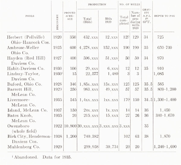
Jillson (l931c) listed 11 gas pools in the Owensboro field which he referred to as the "Panther Creek gas field." The following figures are taken from his report:
 |
SECTION N—MISCELLANEOUS POOLS OF THE WESTERN COAL FIELD
Central City Gas Field.—The Central City field is a small abandoned field, drilled in 1910, a short distance northeast of Central City. Jillson (1931c) reported 20 wells. Production is found a few hundred feet below No. 9 coal. There is little information on structure. The pool lies to the south of the Moorman syncline. No information is available on production.
Sebree Pool.—The Sebree pool is located just north of Sebree in north-eastern Webster County. Gas occurs on a closed anticline about a mile northwest of the Curdsville fault and north of the Sebree fault: The main gas pay is a sandstone 400 feet below No. 9 coal. The first well, which was drilled near the top of the structure, found gas in three sandstones with total open flow of about 5. The sand mentioned above occurred at 390 feet. One hundred feet higher in the section the first gas sand yielded oil on the western side of the structure. Gas was piped to Henderson (Russell, 1934a).
In May 1938 the Iley Browning's No. 5, J. R. Ramsey, drilled to 3217 feet was plugged back to 1405 feet and became a producer in the McCloskey. An initial of 3 barrels per day natural was increased to 50 barrels by acidizing. The well is located a mile south of Sebree on the Sebree anticline.
Niagara Pool.—The Niagara pool is southeast of Niagara in Henderson County on a southwest-plunging anticline, a part of the anticlinal structure north of and paralleling the Curdsville fault. It is the same general structure in which the Birk City pool to the northeast has more recently been opened. Production comes from the same sand as in the Sebree at depths of 500 to 600 feet.
Silver City Pool29 (southern Butler County).—A field of 30 to 40 producing wells in the Jones (Hardinsburg) sand. The wells are small. Production was first encountered in the Brown No. 1 of Evans and Phillips, July 1938 at 506 feet with an initial of 25 barrels. The structure is described as a nose or terrace.
Crofton Gas Field30 (Northern Christian County).—This field is located near Crofton in a large fault block (fault pattern shown on county map, Sutton, 1928). Production is from the Bethel sand on an anticlinal structure with about 40 feet of closure against a north-south fault. Water is encountered down the dip. Wells range up to about 2 M feet.
Belton Pool.29—A small pool with only a few producing wells in the McCloskey in southeastern Muhlenberg County. The pool was discovered in February 1939 with the drilling of Fred Phillips' Shearn Coal Company No. 1 with production at 1545 feet. The structure is an anticline margined by a fault.
Spring Grove Pool.—A small pool of nine producing wells in west central Union County opened by the Sun Oil Company's F. P. Rayburn No. 2. Production is from the Caseyville (Mansfield of Indiana) sandstone at 1342 with initial production of 85 barrels in 18 hours natural. The production is anticlinal and the pool is limited by the small areal extent of the sand lens.
In addition, minor gas strikes have been made:
(a) Near Greenville, Muhlenberg County, in the Bethel.
(b) Near Earlington, Hopkins County, in the Chester and Lower Pennsylvanian. Production is anticlinal with water down the dip.
(c) At Southard, Hopkins County, in the Caseyville.
(d) Near Diamond Springs in Logan County, where a little oil and gas was found in what is probably the Cypress sandstone.
(e) Near Kirkwood, Hopkins County, in the Chester. Production is anticlinal and wells range up to ½ M feet.
SECTION O—GAS POOLS OF MEADE AND BRECKINRIDGE COUNTIES
Meade County Shale Gas Pool.—The early development of gas in Meade County came as a result of drilling for petroleum and is described by Orton (1891). Twenty to 30 wells were drilled between 1863 and 1865 near the site of an old oil-salt water spring on Doe Run southeast of Brandenburg. A well drilled on the Olonzo Moreman farm found a strong flow of gas and salt water at 527 feet, and in 1872 a salt works was established in which the gas was used for evaporation of the brine. The output was eight barrels a day which was increased by the drilling of a couple of additional wells. The search for gas was revived in 1886 after the discovery of Trenton gas in Ohio and Indiana. Renewed drilling in the Doe Run vicinity was not particularly successful. The gas company of Brandenburg drilled about 12 miles upstream from that city and was successful. The first test yielded .8 M in the New Albany shale at 400 feet. Rock pressure was somewhat less than 100 pounds. About 18 wells were drilled in 1887-89 capable of producing 11 M feet. The gas was piped to Louisville and constituted its entire source of natural gas for some years. Jillson (1922c) reported the largest well as having been good for 2 M cubic feet with a rock pressure of 51 pounds.
The occurrence is anticlinal but the local character of the Black shale here, permitting it to act as a reservoir, is not known. Jillson (1931) reported two new drilling wells along with 101 old ones in the Meade County field. He reported the maximum open flow of individual wells at 4½ M and stated that nine recent wells averaged 1½ M each. Some gas is also found below the shale in the Corniferous.
| PRODUCTION DATA THROUGH 1939 From C. D. Hunter et al., 1940 |
 |
Cloverport Pool.—The old Cloverport pool, which is now abandoned, was opened in June 1889, with the completion of a well in the valley of Clover Creek within or near the limits of the town at a depth of 896 feet. The pay was a porous grey limestone, which cannot be correlated closer than Lower Mississippian. Salt water was encountered at 400 and 600 feet. Other wells followed, some for brine rather than gas, and Jillson et al., (1930) showed 14 old wells. The best of the wells is reported to have produced 3½ M initial. Two other wells supplied Cloverport, which is said to have been the first Kentucky town to be supplied with natural gas. Geological conditions controlling production are not known.
Muldraugh Gas Pool (Meade County).31—The Muldraugh pool is a small pool discovered about a dozen years ago producing from the Corniferous and, to a lesser extent, from the New Albany shale. Gas from the former is sour. The structure, as outlined on the Warsaw, is a sharp dome with about 260 feet of closure. The local thinning of Lower Mississippian toward the crest of the dome indicates an early and progressive development of the structure.
The discovery well gauged 2¼ M feet, the average about 3 M, with rock pressure of 122 pounds open flow, and the maximum encountered 9 M. Average depth is somewhat less than 500 feet. The pool is used in part as a storage reservoir for gas piped in from eastern Kentucky and used in Louisville.
Meadow Gas Field.—Shale gas has also been produced in a small shallow field in the Ohio River bottoms of southwestern Jefferson County near Kosmosdale, referred to by Jillson (1931c) as the Meadow gas field. It is encountered in the New Albany shale at 250 to 300 feet. The field has not been a commercial one.
Shrewsbury Field.32—In the last few years an east-west elongated dome near Shrewsbury in southern Grayson County has proved productive of gas from the Chattanooga (New Albany) shale, Beaver sand, and Spergen. The Black shale may prove to be the chief pay. This again raises the question as to the reasons for the local availability of shale gas. It is reported by Stouder (personal communication, 1941) that the thickness of the shale in this vicinity changes rapidly. This same feature has been pointed out (see p. 294) for the shale gas field of Floyd County, etc., in eastern Kentucky.
There seems to be definite structural control, and about 30 square miles on the structure is regarded as proved acreage with an estimated reserve of perhaps 14 billion cubic feet of gas. Rock pressure in the Spergen limestone is about 330 pounds, in the Beaver sand about 500, and in the shale about 540 pounds. The Corniferous is encountered at 1600 to 1850 feet. The wells are shut in awaiting a pipe line.
Sonora Field.32—The Sonora field is a small field in southeastern Hardin County with a limestone pay 50 feet below the Chattanooga, probably the Louisville or Laurel limestone, at about 950 feet. There are eight wells shut in awaiting a market.
A few small low-pressure gas wells have been drilled three miles east of Hodgenville with a total open flow of not more than 1 M feet.
Footnotes
1 Miller, 1919; Jillson, 1919.
2 Freeman (1939a) regarded the lower 40 typically St. Peter. The upper part is
fine grained and calcareous and possibly Stones River.
3 See figure 36, page 353 for other Trenton pays.
4 Gas does occur, though, low in the Corniferous 500 and 600 feet below the
shale in the Mine Fork (Magoffin County), Flat Gap (Johnson County), and Auxier
(Floyd County) fields as well as in the Big Six near Prestonsburg.
5 Paper read before the Appalachian Geological Society, November 8, 1935.
6 From a symposium prepared by the Appalachian Geological Society, 1935.
7 The situation seems to be somewhat like that involved in the distribution of
upper Corniferous production and that of the Big Six and is outlined in a paper
presented before the meeting of the American Association of Petroleum
Geologists, April, 1942, at Denver, Colorado, by R. C. Lafferty and R. N.
Thomas. (See plate CV and notes on pp. 358.)
8 These notes taken from L. B. Freeman, 1938.
9 Some "Corniferous" gas has been found in the Isonville (southern Elliott
County), Flat Gap (northern Johnson County), Mine Fork (northeastern Magoffin
County), and Auxier (northern Floyd County) fields. These are all in the region
of the Paint Creek uplift and are mentioned in connection with Weir sand
production of that region (p. 355).
10 A. M. Miller, 1919, gives the discovery well as on the farm of Uncle Tommy
Ragland.
11 See Irvine-Big Sinking group.
12 These notes are from a study of this field by Phil M. Miles (Master's thesis,
University of Kentucky, 1939) based on data supplied by the Petroleum
Exploration Company of Lexington through the courtesy of Earl Wallace.
13 Structural relationships are summarized in a diagrammatic cross section (Pl.
XXXIII, after Freeman, 1941).
14 As defined by that author.
15 Miller (1919) said only the Beechwood member of the Sellersburg, and this is
confirmed by Savage (1930a).
16 Miller (1919) said up to 60 feet of Osgood to Louisville.
17 Notes mainly from Russell (1934).
18 Notes from Russell, 1934.
19 Notes from Russell, 1934.
20 Sunnybrook production is considered separately with the Burkesville field.
21 The recent report by Kendall Born and H. B. Burwell (1939) on Clay County,
Tennessee is the first comprehensive published work on this field and becomes
the outstanding reference work. His conclusions are equally applicable to
Cumberland, Clinton, and Monroe counties, Kentucky.
22 Mainly Weir sand (Johnson, Lawrence, Magoffin, and Elliott counties).
23 Notes supplied by George Straughan.
24 Now commonly spelled Barlow in referring to the sand.
25 Notes from E. A. Barnes.
26 Notes from E. A. Barnes.
27 Notes from E. A. Barnes.
28 Notes from E. A. Barnes.
29 Notes from E. A. Barnes.
30 Notes from R. C. Lafferty.
31 Notes from R. E. Stouder.
32 These notes from information supplied by D. J. Jones.