
The Kentucky Geological Survey has archived this material, meaning (1) it is for reference, research, or recordkeeping; (2) it was created before April 24, 2026; (3) and the material has not been changed or altered since being archived. Please refer to our KGS Accessibility page for more information.
KGS Home > News and Announcements
New Eastern Kentucky Geologic Map Released by KGS
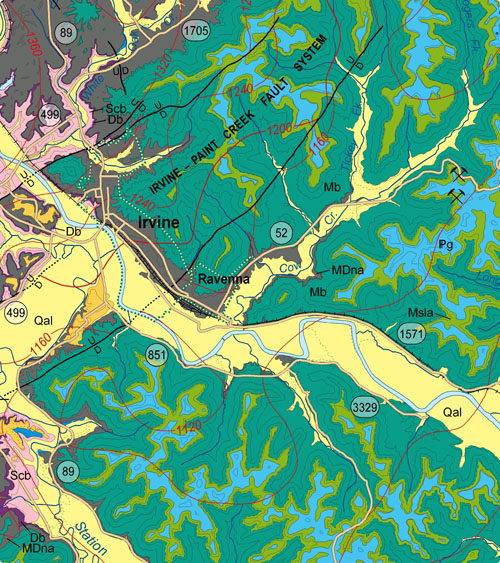
Lexington, KY. (September 4, 2008) - The latest in a series of maps from the Kentucky Geological Survey at the University of Kentucky depicts the economic and engineering geology of the Irvine/Stanton to Salyersville area and surrounding counties of east-central Kentucky. The map, entitled Geologic Map of the Irvine 30 x 60 Minute Quadrangle, Eastern Kentucky, is available in digital form at the KGS web site or as a printed publication from the KGS.
Thirty-two digitized 7.5-minute geologic quadrangles of the area, known as Digitally Vectorized Geologic Quadrangle (DVGQ) maps, were assembled to create the new geologic map.It was compiled and authored by Tom Sparks and Warren Anderson of KGS and Lance Morris, formerly a KGS geologist now with the City of Owensboro, Ky. It is the 15th of a series of such maps developed and published by KGS.
Kentucky is geologically mapped at a scale of 1:24,000 by a total of 707 of the 7.5-minute geologic quadrangle maps. KGS has converted the original paper versions of these large scale maps to digital vector format. The newly compiled map, at a scale of 1:100,000, has kept the accuracy and detail of the original ones used to create it while also allowing a regional perspective on the geologic setting at the new scale.
The map, encompassing an area of approximately 1,900 square miles, includes all or significant portions of the Kentucky counties of Montgomery, Powell, Estill, Menifee, Lee, Wolfe, Breathitt, Morgan, and Magoffin. The cities of Irvine, Ravenna, Beattyville, Campton, Frenchburg, Jackson, West Liberty, Salyersville, Stanton, Clay City, Jeffersonville, and Camargo are also located on the map.
The mapped area includes two major fault systems, the Kentucky River and Irvine-Paint Creek Fault Systems. Several oil fields have been developed along these systems, where petroleum resources have accumulated. In addition, the mapped area extends almost completely across the middle of the Eastern Kentucky Coal Field, where coal has been mined for over a century. Text portions of the publication detail the information on these resources.
Community planners will find valuable information on the map on topics including geologic hazards, such as landslides and soil creep. Logging, removal of vegetation, and mining, among other human activities, can destabilize slopes and contribute to land sliding, which threatens buildings and infrastructure in the region.
The digital vector files used to create this map are available from KGS on CD-ROM for $10 per individual DVGQ and can be used in geographic information systems (GIS) and other computer software. The digital data sets allow GIS users to combine the geologic map data with other data for multiple purposes, including geologic hazard mitigation and assessment of energy and mineral resources. The digital data sets can also be used to create custom maps; they are ideal for land-use development and planning.
To view this publication on-line, go to the KGS Publications & Map catalog at https://kgs.uky.edu/kgsweb/findpubsmain.asp. Enter the publication number, 17226, in the box next to “Enter Publication Number or SkuCode;” to the right of this box select "exact publication id" from the menu. Clicking the “Search” button opens a new page with a link to the map.
Paper copies of the map are available from the KGS Public Information Center for $10 each plus shipping and may be ordered by calling (859) 257-3896 or toll free at (877) 778-7827.
NOTE: New online KGS publication Foundation Problems and Pyrite Oxidation in the Chattanooga Shale, Estill County, Kentucky, publication # 17221, detailing a specific geotechnical issue relating to building damages in the same mapped area, may be of interest to readers of the above publication.