Lexington, Ky. (December 11, 2014) A new online map service has been created by the Kentucky Geological Survey at the University of Kentucky to provide locations and detailed information on Kentucky disposal wells. These wells are used for the safe disposal of industrial wastewater, hazardous chemicals, and brines (salt water) produced in the petroleum, chemical, and limestone mining industries. Others are used for the injection of brines, water, and other fluids for enhanced oil recovery projects. The map service, located at https://goo.gl/xQZ2QD, is an updated and interactive version of a KGS publication released in 2013, "Class I Waste-Disposal Wells and Class II Brine-Injection Wells in Kentucky" (Map and Chart 204, 2013, available at https://goo.gl/6S1SRO).
"The primary focus of the 2013 publication was depiction of the physical locations and operational data on Kentucky’s industrial waste and saltwater disposal wells that fall under the U.S EPA’s Underground Injection Control Program," says Tom Sparks of the KGS Energy and Minerals Section. "The new online service has added considerably more EPA-regulated injection and disposal wells, particularly enhanced recovery wells. We determined that an interactive website would be the best method of presenting spatial and tabular data for the larger number of wells."Sparks is the chief author of both the publication and the new map service.
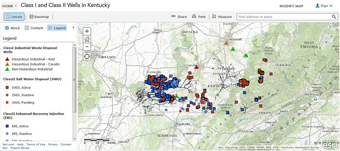
A total of 3,083 Kentucky wells are depicted by symbols on the map service: 11 Class I industrial waste-disposal wells, 135 Class II saltwater disposal wells, and 2,937 Class II enhanced oil recovery injection wells. Clicking on a well’s symbol will bring up available information about it, including EPA identification number, KGS record number, well type, status, and injection formation.
The map service, which can benefit the oil and gas exploration industry, also provides information on gas and oil fields in Kentucky. Clicking inside the outlines of a field will show this information. A map legend on the left side of the interactive map provides a guide to the symbols, as well as map layers and attributes users can select.
Doug Curl, manager of the KGS Geoscience Information Section, assisted Sparks in creating the database and map service.
For more information on the EPA Underground Injection Control program, see https://water.epa.gov/type/groundwater/uic/.