
The Kentucky Geological Survey has archived this material, meaning (1) it is for reference, research, or recordkeeping; (2) it was created before April 24, 2026; (3) and the material has not been changed or altered since being archived. Please refer to our KGS Accessibility page for more information.
KGS Home > News and Announcements
New map of waste disposal wells in Kentucky released by Kentucky Geological Survey
A new map, available for free downloading, has been released by the Kentucky Geological Survey at the University of Kentucky, providing locations and other information on wells used for the disposal of industrial waste water, hazardous chemicals, and brines (salt water). The publication, Class I Waste-Disposal Wells and Class II Brine-Injection Wells in Kentucky (Map and Chart 204, 2013), will be useful for the oil- and gas-production industry in Kentucky as well as anyone interested in the safe practice of underground waste disposal in the state.
"The map provides information about type, name, and location of these wells in Kentucky, as well as the geology and depth of injection zone for these disposal wells across the state," says the principal author, Tom Sparks, of the KGS Energy and Minerals Section. “Such wells are designed to protect underground water that may be used for human consumption." The wells shown on the map are U.S. EPA-permitted Class I wells, used for industrial and municipal waste-disposal, and Class II wells for deep injection of brine from oil and gas drilling operations. Information about 11 Class I wells and 87 Class II wells, including plugged, inactive, and currently operating ones, are depicted.
Sparks requested information in 2012 on the Underground Injection Control (UIC) program wells as permitted by EPA so that the information could be compared with the KGS oil and gas well database. “Some oil and gas wells are converted to disposal wells after their useful lifetime," Sparks says. “We don’t always know which wells have been converted, and the EPA UIC permit information helped us to identify these wells."
A large map of Kentucky occupies most of the 35 inch by 20 inch map, with the well locations marked. Color-coded symbols and text indicate the type of well as well as the geology, age, and depth of the injection zone. The text on the publication provides the background and purpose of the publication, and several tables give information on each well, such as operator, well name, status, and ID numbers (if available), for all Class II disposal wells.
Sparks says the information can help industries determine the best sites for wastes that can be injected for permanent deep storage. Co-authors on the map are Dave Harris and Rick Bowersox, also of the KGS Energy and Minerals Section.
The map can be viewed and downloaded from this KGS Web page https://kgs.uky.edu/kgsweb/olops/pub/kgs/MC204_12.pdf. Paper copies of the map are available from the KGS Public Information Center on the UK campus for $10 each plus shipping. They may be ordered by calling (859) 257-3896, or toll free at (877) 778-7827, and asking for publication number 17724.
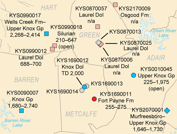
Detailed section from Class I Waste-Disposal Wells and Class II Brine-Injection Wells in Kentucky.
Click here to download map (pdf)