|
|
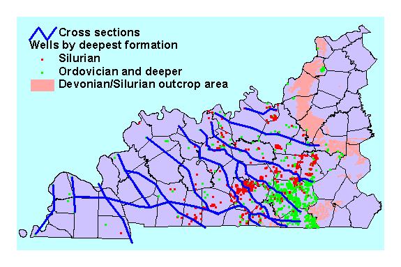
| Cross section network for the subsurface study of the Silurian and Devonian of western Kentucky |
Contact: Ann Watson
|
|
| Cross section network for the subsurface study of the Silurian and Devonian of western Kentucky |
 Commonly referred to as the "Corniferous," Silurian and
Devonian rocks on either side of the Cincinnati Arch have produced a significant portion of Kentucky's oil. Because most production has been associated with trapping along erosional unconformities
next to the arch, little has been known about the Corniferous stratigraphy in the deeper parts of adjacent basins.
Commonly referred to as the "Corniferous," Silurian and
Devonian rocks on either side of the Cincinnati Arch have produced a significant portion of Kentucky's oil. Because most production has been associated with trapping along erosional unconformities
next to the arch, little has been known about the Corniferous stratigraphy in the deeper parts of adjacent basins.
The western Kentucky portion of the Illinois Basin is bounded on the east and southeast by the Cincinnati Arch, and is superimposed on the Rough Creek Graben, a Cambrian basement rift zone. In the past few years, new geophysical-log data and studies of the basement structure of western Kentucky have become available, making feasible a more thorough investigation of the Silurian-Devonian subsurface than has been done previously.
For the first segment of the study, a series of structural and stratigraphic cross sections has been defined, which will be followed by subsurface mapping. The cross-section grid placement is based on previous mapping, which suggests two major Silurian carbonate depocenters in southeastern Illinois and southwestern Indiana, and a comparatively minor depocenter paralleling the Rough Creek Graben. Well-sample descriptions, and gamma-ray, photoelectric, formation-density, and neutron-log data are being used to determine stratigraphic tops. These data will be integrated with basement structure to gain a greater appreciation of unconformable relationships within the strata, and a more thorough understanding of tectonic effects on sediment deposition during Silurian and Middle Devonian time.
In cooperation with the ongoing digital geologic mapping project, this project will also assume responsibility for digitizing 10 of the 7.5-minute geologic quadrangle maps that cover Corniferous outcrops in west-central Kentucky. The research will combine these digital surface geologic maps with subsurface correlations to produce an integrated three-dimensional model of Corniferous geology.