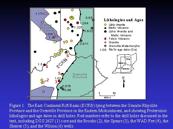
The East Continent Rift Basin (ECRB) was defined by Drahovzal and others (1992) as a largely Proterozoic sedimentary basin with associated volcanic rocks lying west of the Grenville Front in Kentucky, Indiana, and Ohio (Fig. 1). The potential for carbon sequestration in the clastic and mafic rocks that have been drilled in the region has not been previously discussed. The following is a discussion of what is known of the extent and nature of some of these Proterozoic rocks and their potential for future carbon sequestration efforts.
In 1989, 1,922 feet of Middle Run Formation, a lithic arenite, was penetrated in core hole DGS 2627 (Fig. 1, well 1) in southwestern Ohio (Shrake, 1991; Shrake and others, 1990, 1991). Subsequent work by the Cincinnati Arch Consortium indicated that rocks of a similar lithology underlaid a far more extensive area of the eastern Midcontinent (Drahovzal and others, 1992). In some instances the lithic arenites are interbedded with mafic and felsic volcanic rocks. Indications are that the arenites represent alluvial fan or distal facies equivalents in an arid continental, volcanically active rift zone. The core and drill cuttings and the wireline logs from wells in the area indicate that the lithic arenites show negligible porosity and permeability and are therefore poor reservoirs (Drahovzal and others, 1992). One possible exception is the K II No.1 Brooks well in Hart Co., Ky., drilled in 1997 (Fig. 1, well 2; Fig. 2).
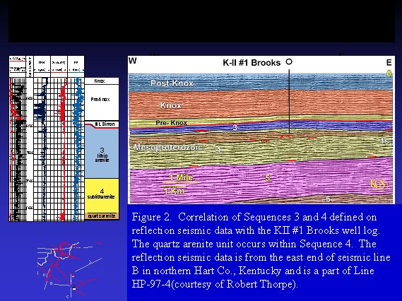
The Brooks well penetrated 1,789 feet of three slightly different types of Proterozoic lithic arenite lithologies and was drilled to a total depth of 8,257 feet (Fig. 2). Just beneath the Precambrian unconformity at 6468 feet is 982 feet of a red-brown, medium-grained lithic arenite with rhyolite rock fragments, which is closely similar to the Middle Run of Ohio and may be its equivalent. A comparison of drill cuttings from the Brooks well and those of the Ohio core (Fig. 1, well 1) are indistinguishable under a binocular microscope. Below the lithic arenite is a 650-foot interval of gray-pink, medium- to coarse-grained sublitharenite, being less lithic rich and more quartz rich than the interval above. The distinction between the two units is barely noticeable on the gamma ray log, but is readily seen on the photoelectric log (PE), with higher PE values for the lithic arenite interval. The distinctive nature of the unit was first indicated on reflection seismic data analysis and then confirmed by re-examination of the well cuttings. At the base of the well is 157 feet of gray-pink, medium-grained quartzarenite to sublitharenite that is more quartz rich than the sublitharenite. This interval is distinct in that it contains disaggregated quartz grains, indicating poor cementation and possible porosity. The suggestion of porosity is confirmed by the markedly higher sonic porosity values in the quartzarenite interval.
It is this lowermost interval of quartzarenite that may hold the most significance for future carbon sequestration efforts. As the interval was being drilled, pressured gas of unknown composition blew drilling mud to the drilling-rig floor (Robert Thorpe, personal communication, 1997). This occurrence suggests that the quartzarenite zone, in addition to being porous, may have considerable permeability and could be a zone for consideration relative to carbon sequestration. About 9 months after the drilling, the company set pipe in the hole and perforated the zone, but the interval did not show any type of flow response. Unfortunately, quantitative measurements are not available from this test. The company reentered the hole in 2002 and attempted to fracture the interval, but was unable to do so with reasonable pressure buildups (Robert Thorpe, personal communication, 2002). It is possible that formation damage occurred during the time that the hole remained uncompleted, preventing the formation from showing further indications of permeability. Robert Thorpe is not certain, however, that the proper interval was pressured during the fracing procedure. The full thickness of the quartzarenite permeable zone is unknown from drill data in the area.
Seismic data available in the area, however, shed additional light on the quartzarenite
zone and the thick interval of clastic and volcanic rocks that make up the Proterozoic
geology of central Kentucky. Two primary sequences and a secondary unit have
been defined that correspond to changes in lithology noted in drill cuttings
from the Brooks well (Fig 2). The lack of seismic data farther north preclude
correlations into northern Kentucky and adjacent Indiana and Ohio (Fig. 3).
Seismic data correlations west of the Louisville Fault in Kentucky are uncertain.
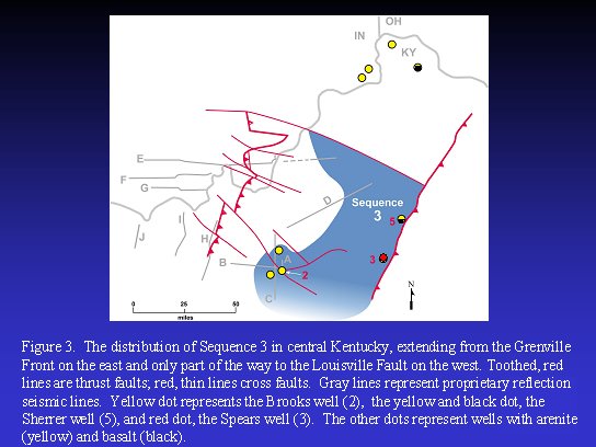
The sequence directly beneath the Precambrian unconformity has been arbitrarily referred to as sequence 3 on seismic data (sequences 1 and 2 are younger and known only from seismic data farther northeast of the Brooks well along the east end of seismic line E). Sequence 3 correlates to the lithic arenite and, as noted above, is likely equivalent to the Middle Run drilled in the DGS 2627 well in southwest Ohio. Sequence 3 in Kentucky is confined to the eastern part of central Kentucky, being sharply truncated by the deep downcutting Precambrian unconformity to the west of the Brooks well (Fig. 3). Farther north, the unconformity dips more gently westward. Where data are available in central Kentucky, its thickness ranges from a feather edge to the west and up to more than 6,200 feet to the east. Near the Grenville Front, its thickness may be even greater. Sequence 3 onlaps onto the underlying sequence 4 rocks both to the east and to the west (note red lines indicating onlap onto a preexisting high near the well in Figure 2) and shows a distinct angular relationship locally where sequence 4 is deformed by earlier structural activity. This suggests that the hiatus between the two sequences is considerable. Sequence 3 shows evidence of contemporaneous rifting, later thrusting, and even later wrench faulting. Based on the California No. 1 Spears well, near the Grenville Front (Fig. 3, well 3), sequence 3 apparently interfingers with rhyolite whose age is1.02 Ga (Bass, written communication, 1969; Drahovzal and others, 1992). This age is apparently representative of a part of sequence 3.
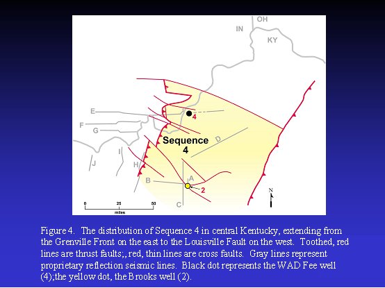
Sequence 4, composed of sublitharenite and quartzarenite, is present over the
entire area of central Kentucky, being poorly known to the north and not distinguishable
west of the Louisville Fault (Fig. 4). To the north near seismic line E, part
of the sequence is composed of volcanic rock that apparently interfingers with
the arenites. The DuPont No. 1 WAD Fee well drilled 82 feet of basalt (Lidiak
and Zietz, 1976; also referred to as gabbro by Steve Bergman, written communication,
1993) directly beneath the Precambrian unconformity (Fig. 4, well 4). The arenites
of sequence 4 are characterized by mounded reflectors that are common near the
top and at the base of the sequence (note red lines indicating downlap near
the base of the brown zone in Figure 2). Sequence 4 attains a thickness of more
than 9,800 feet to the south of the Brooks well. To the northwest, just east
of the Rough Creek Graben, the thickness of the unit is diminished to about
3,300 feet by the sharp westward downcutting of the Precambrian unconformity.
Farther to the north, near the east end of seismic line E, and apparently deeper
into the basin, the sequence is more than 7,800 feet thick. However, thrusting
is responsible for much of this apparent thickening. The sequence shows gentle
eastward onlap onto the underlying sequence 5 (note red lines indicating onlap
at the base of sequence 4 in Figure 2). Sequence 4 is generally cut by wrench
faults, and folded and cut by thrust faults. The apparent age range of part
of the sequence is on the order of 1.5 Ga, based on the age of the basalt in
the WAD Fee well (Fig. 4, well 4; Steve Bergman, written communication, 1993).
The basalt in this well, however, is on an eroded high and represents some of
the oldest parts of the sequence. Presumably much of the sequence is younger.
Part of sequence 4 is characterized by the permeable quartzarenite discussed above. Reflection seismic data reveal more about its distribution, thickness, and depositional environment. Based on seismic data, the quartzarenite could be on the order of 650 feet thick in the vicinity of the well, being situated in a local eroded low (Fig. 2). The seismic data show that the unit thickens to the west up to more than 1,200 feet and thins to the east to as little as 340 feet. About 12 miles to the west on seismic line B, the unit pinches out by the downcutting of sequence 3. Several apparent mounded reflectors and the somewhat incised nature of the lower contact suggest that the unit represents a fan deposit that locally scoured the underlying part of sequence 4 (note red lines indicating downlap near the base of the brown zone in Figure 2). The suggestion of fan deposits at the base suggests that an arenaceous lithology probably persists throughout much of the unit. The thinning to the east suggests that there may be a limited volume of carbon-sequestration capacity in the unit in central Kentucky, but much more information from both drill and reflection seismic data will be needed to more fully evaluate it for its future potential.
Future studies may also reveal other clastic units within this thick sequence of Proterozoic arenaceous rocks that may be appropriate for carbon sequestration. In addition, seismic reflection studies in areas to the west and north, in Indiana, Ohio, western Kentucky, and Illinois, have revealed the possibility of similar clastic rocks expressed in seismic data as layered reflectors lying beneath the Precambrian unconformity (Pratt and others, 1989, 1992; Wolfe and others, 1993; Stark, 1995, 1997a, b; Bear and others, 1997; Drahovzal, 1997; Potter and others, 1997; McBride and Kolata, 1999; Dean and Baranoski, 2002a, b). The rocks represented by Proterozoic layered reflectors in these areas also need to be examined for their potential as carbon dioxide sinks.
In addition to the clastic units, the Proterozoic mafic volcanic rocks present in several wells could also offer future sites for mineral sequestration of carbon dioxide. They include the basalt in the WAD Fee and the Texaco No. 1 Sherrer wells (Fig. 1, wells 4 and 5, respectively). Proterozoic mafic volcanic rocks are also present in the Ashland Oil No.1 Wilson well in northern Kentucky (Fig. 1, well 6) and other mafic rocks occur in wells in both Ohio and Indiana. In all of these cases, the degree of fracturing of the mafic volcanic rocks is unknown.
Bear, G.W., Rupp, J.A., and Rudman, A.J., 1997, Seismic interpretation of the deep structure of the Wabash Valley Fault system: Seismological Research Letters, v. 68, p. 624-640.
Dean, S.L., and Baranoski, M.T., 2002a, Ohio Precambrian 1: A look at western Ohio's Precambrian tectonic setting: Oil and Gas Journal, v. 100, no. 29, p. 34-37.
Dean, S.L., and Baranoski, M.T., 2002b, Ohio Precambrian 2: Deeper study of Precambrian warranted in western Ohio: Oil and Gas Journal, v. 100, no. 30, p. 37-40.
Drahovzal, J.A., 1997, Proterozoic sequences and their implications for Precambrian and Cambrian geologic evolution of western Kentucky: Evidence from seismic-reflection data: Seismological Research Letters, v. 68, no. 4, p. 553-566.
Drahovzal, J.A., Harris, D.C., Wickstrom, L.H., Walker, D., Baranoski, M.T., Keith, B.D., and Furer, L.C., 1992, The East Continent Rift Basin: A new discovery: Kentucky Geological Survey, ser. 11, Special Publication 18, 25 p.
Lidiak, E.G., and Zietz, I., 1976, Interpretation of aeromagnetic anomalies between latitudes 37°N and 38°N in the eastern and central United States: Geological Society of America Special Paper 167, 37 p.
McBride, J.H., and Kolata, D.R., 1999, Upper crust beneath the central Illinois Basin, United States: Geological Society of America Bulletin, v. 11, no. 3, p. 375-394.
Pratt, T., Culotta,R., Hauser, E., Nelson, D., Brown, L., Kaufman, S., Oliver, J., and Hinze, W., 1989, Major Proterozoic basement features of the eastern Midcontinent of North America revealed by recent COCORP profiling: Geology, v. 17, p. 505-509.
Pratt, T., Culotta, R.C., Hauser, E.C., and Nelson, K.D., 1992, Widespread buried Precambrian layered sequences in the U.S. Midcontinent: American Association of Petroleum Geologists Bulletin, v. 76, p. 1384-1401.
Potter, D.J., Drahovzal, J.A., Sargent, M.L., and McBride, J.H., 1997, Proterozoic structure, Cambrian rifting, and younger faulting as revealed by a regional seismic reflection network in the southern Illinois Basin: Seismological Research Letters, v. 68, no. 4, p. 537-552.
Shrake, D.L., 1991, The Middle Run Formation: A new stratigraphic unit in the subsurface of southwestern Ohio: Ohio Journal of Science, v. 91, p. 49-55.
Shrake, D.L., Carlton, R.W., Wickstrom, L.H., Potter, P.E., Richard, B.H., Wolfe, P.J., and Sitler, G.W., 1991, Pre-Mount Simon Basin under the Cincinnati Arch: Geology, v. 19, p. 139-142.
Shrake, D.L., Wolfe, P.J., Richard, B.H., Swinford, E.M., Wickstrom, L.H., Potter, P.E., and Sitler, G.W., 1990, Lithologic and geophysical description of a continuously cored hole in Warren County, Ohio, including description of the Middle Run Formation (Precambrian?) and a seismic profile across core site: Ohio Geological Survey Information Circular 56, 11 p.
Stark, T.J., 1995, In search of the East Continent Rift Complex: Evidence and conclusions, in Ojakangas, R.W., et al, eds., Basement tectonics: Dordrecht, The Netherlands, Kluwer, v. 10, p. 103-105.
Stark , T.J., 1997a, The East Continent Rift Complex: Evidence and conclusions, in Ojakangas, R.W., Dickas, A.B., and Green, J.C., eds., Middle Proterozoic to Cambrian rifting, central North America: Geological Society of America Special Paper 312, p. 253-266.
Stark, T.J., 1997b, The English Graben: A possible Precambrian rift segment of the eastern Midcontinent, in Ojakangas, R.W., Dickas, A.B., and Green, J.C., eds., Middle Proterozoic to Cambrian rifting, central North America: Geological Society of America Special Paper 312, p. 267-285.
Wolfe, P.J., Richard, B.H., and Potter, P.E., 1993, Potential seen in Middle Run basins of western Ohio: Oil and Gas Journal, v. 91, no. 14, p. 68-73.