SILURIAN
 |
|
(After Foerste, 1931, p. 173.)
* Centerville (Foerste, 1931).-The type section is at Centerville, Ohio, and
consists of 2½
feet of indurated
clay
formerly regarded as the top of the Elkhorn. The
fauna consists of a number of Silurian forms associated
with
others of an
Ordovician aspect. Foerste correlated it provisionally with the Edgewood of
Illinois.
This
horizon
has not been identified in Kentucky but is known at West Union,
Ohio, six miles north of the Ohio River. |
The Silurian outcrops in a narrow band on the eastern and western margin of the
Blue Grass. Along the southern margin it is overlapped from both the east and
west by the Mid-Devonian limestone (Boyle-Jeffersonville), which, along the
axis of the Arch in Boyle County, rests on the Ordovician as low as the Tate.
Locally also the Boyle limestone is missing and the Ohio shale rests on the
pre-Devonian.
EAST SIDE OF CINCINNATI ARCH
Brassfield.1—The Brassfield is the only one of the Silurian formations which has
been identified on both sides of the Arch. It is Orton's Ohio Clinton, named by
Foerste (1906) and correlated with the Cataract (Alexandrian). The type section
along the Louisville and Atlantic Railroad between Brassfield and Panola in
Madison County, Kentucky shows:
|
Feet
Ferruginous limestone............................................... 1.5
Horizon with large crinoid beads and Whitfieldella subquadrata
Irregularly
bedded limestone with very little clay.................... 2
Clay, forming from one-half to three-fourths of the section, interbedded
with thin limestone.............................................. 2.3
Limestone, irregularly bedded with thin clay partings................ 8.2
Very massive bluish limestone, apparently unfossiliferous............ 6
20.0 |
Northward it thickens to 40 or even 50 feet in Adams and Highland counties,
Ohio, and then thins westward into Indiana. In the southern Blue Grass the
Brassfield thins westward and is eliminated from the section near Stanford,
where the Devonian overlaps on the Ordovician. A small outlying remnant occurs
on Scrub Grass Creek, 3 miles southwest of Mitchellsburg in western Boyle
County, Kentucky. Small discontinuous areas occur along the Cumberland River
about 15 miles west of Burnside and on Fishing Creek west of Somerset. On the
west of the Arch the Brassfield has a thickness of about 5 feet in Trimble and
Oldham counties, 3 feet east of Louisville (7 feet locally), and somewhat more
in Nelson and western Marion counties.
The formation consists of medium to coarsely crystalline grey to pink dolomitic
limestone, commonly sandy in appearance and weathering brown. The lower part is
usually massive. Above, it is relatively thin bedded, is associated with shale,
and is more fossiliferous. Large characteristic crinoid "beads" one-half to 1
inch in diameter, many with a cogwheel (scalloped) outline, occur near the top.
This is overlain by the zone of Whitfieldella subquadrata. Whitfieldella
quadrangularis occupies the same horizon in Adams County, Ohio. The top layers
are often ripple marked. The layers above the crinoidal zone are frequently
ferruginous from Clay City northward, and near Olympia in Bath County carry the
Clinton type of flaxseed (oolitic) hematite ore. The lower Brassfield is very
cherty from Bath County northward, and a cherty phase is also developed near
Bardstown. On Jeptha Knob in Shelby County Silurian dolomites, resting with
angular unconformity on the Ordovician, contain lenses of breccia showing a
mixture of Brassfield and Ordovician fossils.
The Brassfield is rather sparingly fossiliferous in the southern area of outcrop
in central Kentucky, but is quite fossiliferous in Ohio and Indiana and
adjoining parts of Kentucky. The zone of large crinoid "beads" and the overlying
Whitfieldella beds are characteristic of the uppermost layers in the eastern
area of outcrop. The rather thin-bedded zone below has yielded the greater part
of the fauna in which brachiopods, bryozoans, and corals are most common. The
more common and consistently present forms include:
Camarotoechia neglecta
Dalmanella elegantula
Leptaena rhomboidalis
Orthis flabellites
Platystrophia daytonensis
Platystrophia reversata
Sowerbyella transversalis |
Strophonella daytonensis
Rhinopora verrucosa
Enterolasma caliculum
Zaphrentis celator var. daytonensis
Cyclonema daytonense
Calymene niagarensis
Calymene vogdesi |
It is a widely distributed formation with fauna of southern origin and is known
from Oklahoma, Arkansas, and Alabama through to Indiana, Illinois, western New
York, and Ontario (Foerste, 1935). At Birmingham, Alabama that part of the Red
Mountain formation below the Big seam, including the Irondale seam and other
seams of "Clinton ore," is Brassfield (Butts, 1927).
"Approximately the same horizon is exposed by the Sexton Creek limestone in
southwestern Illinois and adjacent part of Missouri, and by the Kankakee
limestone in northeastern Illinois. In southern Ontario the faunas most similar
to the Brassfield of Ohio are those of the Cabot Head shale and of the
underlying Manitoulin dolomite, the bryozoans being more common in the shale
though most species are common to both" (Foerste, 1935, p. 189).
Plum Creek Shale (Foerste, 1906).—The Plum Creek is a local shale formation with
a little interbedded limestone and about 5 feet thick known from the vicinity of
Indian Fields (Clark County) north to Clay City in Powell County. Both to the
north and south it loses its identity, as limestone becomes more common. Fossils
are few.
Oldham limestone2 (Foerste, 1906).—The Oldham is thin to medium and unevenly
bedded magnesium limestone interbedded with blue shale. Many surfaces show
fucoidal markings. Selenite crystals occur in some of the shales.
The formation is less well-marked southwest of Berea because of the lack of
fossils and change in lithology. It has been traced north to near Owingsville.
At Ribolt, 10 miles west of Vanceburg in Lewis County, the limestone overlying
the Brassfield is regarded as Dayton (Foerste, 1935).
In its typical development the top of the limestone is characterized by abundant
Stricklandinia norwoodi. Foerste (1935) called attention to the occurrence of
the Pentamerus zone (Dayton) above the Stricklandinia zone at Birmingham, thus
suggesting the relative ages of the two. They are unknown in the same section in
Kentucky. Thickness, 10 to 15 feet.
Alger (Foerste, 1906).—The remainder of the Crab Orchard is composed of the
Lulbegrud shale, Waco limestone, and Estill clay. To the north of Powell and
Clark counties the Waco limestone disappears as a recognizable unit and the
undifferentiated shale succession was referred to by Foerste as the Alger. The
upper part of these shales is fossiliferous, and has since been differentiated
as the Ribolt.
Lulbegrud clay (Foerste, 1906).—A blue unfossiliferous shale about 13 feet thick
in exposures on Lulbegrud Creek, where it forms the boundary between Powell and
Clark counties. At Crab Orchard it is only 6 feet thick. Its northern extent and
differentiation from the Estill clay is determined by the northern limit of the
Waco limestone. Ground water in it is often impregnated with epsom salts, and
selenite crystals are not uncommon.
Waco limestone (Foerste, 1906).—A magnesian limestone ranging up to 10 feet
thick. The base is marked by a one- to two-foot heavy layer succeeded by
interbedded thin limestones and shale. Miller (1919) mentioned radial fucoid
markings as characteristic. It has not been differentiated in the section
except in Madison, Clark, Powell, and Estill counties.
The Waco is quite fossiliferous. The fauna consists largely of corals and
resembles the Dayton in this respect. It does not resemble other known Clinton
faunas. Characteristic forms include Strombodes mamillaris var. distans, S.
granulosus, Favosites gothlandicus, Lindstromia lingulifera, Heliolites
spongiosus, and Meekopora bassleri.
Estill clay (Foerste, 1906).—The Estill Clay consists of nonfossiliferous blue
shales, which locally attain a thickness of 100 feet. At the type locality near
Estill Springs the thickness is 56 feet. In the absence of the Waco limestone it
is part of the undifferentiated Alger. From Clark and Madison counties south it
is overlain by the Devonian.
Ribolt (Foerste, 1931).—In Lewis County a clay shale at least 100 feet thick
overlies the Dayton limestone. Thin indurated layers, often only one-fourth inch
thick, are interbedded with the shale in the upper part. For this upper part
with its distinctive Mastigobolbina typus fauna the name Ribolt was proposed.
For the lower shales the term Alger is retained. The fauna, characteristic of
the middle part of the upper Clinton is well known in Virginia, West Virginia,
Maryland, and Pennsylvania (Foerste, 1931). It is 30 feet thick in Lewis County,
is known to be present in Ohio, but not farther south in Kentucky.
Bisher (Foerste, 1917).—The Bisher is typically developed in Adams and Highland
counties, Ohio; is known in Lewis County, Kentucky, and in outcrop as far south
as the northern edge of Fleming County. It is an impure grey even-bedded rather
fine-grained granular dolomite, which weathers to a yellow and brown "sandy"
rock. Fossils are commonly present as moulds. There are interbedded crinoidal
layers. A fossiliferous zone about 10 feet above the base is characterized by
Whitfieldella cylindrica. Associated with it are Stropheodonta plana,
Schuchertella proserri, Spirifer radiatus, Atrypa elongata, Camarotoechia roadsi,
Dalmanites limulurus var. brevicaudatus, and Bumastus ioxus.
Lilley (Foerste, 1917).—This is a medium- to coarse-grained rather soft grey
dolomite, much of it highly crinoidal. It weathers brown. Bedding planes are
rather uneven and hackley. Many layers contain fragments of Cladopora which is
distinctive. Corals occur in considerable numbers, particularly at the base.
Halysites and a small Stromatoporoid are common. Holophragma calceoides is
common in a shale zone near the top.
A number of corals including Coenites verticillatus, Cystiphyllum niagarense,
Omphyma verrucosa, Plasmopora follis, and Strombodes striatus suggest a
Louisville (Lockport) age. It is not known in outcrop in Kentucky but has been
identified (McFarlan, 1938d) as an oil producing formation in the Irvine oil
field, Estill County. Diamond cores have shown a thickness of 43 feet, but there
is no reason to believe the formation was drilled through.
Peebles (Foerste, 1929).—The Peebles has been traced south to the Ohio River in
Adams County and adjoining parts of Kentucky. It is unknown in outcrop farther
south but has been recognized in drill cores from the Irvine field, Estill
County, where it is an outstanding producer of petroleum, and with the Lilley
constitutes the "Corniferous" pay (McFarlan, 1938d). Here it has a known
thickness up to 30 feet. The abundant asphaltic residue in the Peebles at the
Basic Products Quarry east of Peebles, Ohio, is in keeping with this.
It is fine-grained hard grey dolomite weathering light grey. A rather
characteristic feature is a texture involving an irregular patchy distribution
of fine to dense and somewhat coarser grained patches that are petroliferous,
In the eastern end of the Irvine oil pool a sandstone facies is developed in the
lower part.
The formation is highly fossiliferous and has been referred to as the Pentamerus
zone. The upper part contains a Guelph assemblage including Megalomus canadensis,
Trimerella ohioensis, Pycnostylus guelphensis and various gastropods (Foerste,
1935). Halysites is common as are also Stromatoporoids. It has been regarded as
Cedarville but was correlated by Foerste (1931, 1935) with the Guelph and would
thus overlap the Cedarville.
UPPER SILURIAN
The Cayugan is unrepresented in the exposed section in Kentucky, nor is it shown
in the drill cores of the Irvine pool mentioned above. However, the limestone
section between the Ohio shale and Crab Orchard thickens eastward from a few
feet to 500 and 600 feet in Magoffin and Lawrence counties. With the presence of
the Cayugan and Helderberg in the section where these beds again come to the
surface at Big Stone Gap, Virginia, the Cayugan would seem to be present under
the Eastern Coal Field. Ballard (1938) has recently recognized both Cayugan and
Helderberg in the subsurface section in Wolfe County and eastward, thus
completing the picture of the Mid-Devonian overlap. He also described a
sandstone (Big Six oil sand) at the base of the Cayugan, which he regarded as
erosional debris occupying the position normally held by the Niagara dolomite.3
It has a known range in thickness up to 60 feet and is overlain by dolomite with
anhydrite scattered through it.
WEST SIDE OF CINCINNATI ARCH
Brassfield.—Described on page 35.
Osgood (Foerste, 1897).—The Osgood formation includes the beds between the
well-defined Brassfield below and Laurel above.
In Jefferson County Butts recognized four divisions with a total thickness of
about 30 feet.
(d) Upper shale, 2 to 3 feet of soft, fairly fissile, greenish grey shale,
(c) Five to 8 feet of fine-grained magnesian limestone in one-foot layers,
(b) Twelve to 20 feet of coarse, lumpy, grey, calcareous and magnesian shale,
(a) About 2 feet of limestone much like that of the Brassfield but resting
disconformably on it.
The divisions are persistent. The Osgood itself is known from Tennessee to
southern Indiana, and in Kentucky may be traced south into Nelson County.
Fossils are present but not to the same extent that they are present in the
region of the type locality in Indiana. The rather limited fauna that Butts
found in Jefferson County includes:
Enterolasma caliculum
Favosites cristatus
Striatopora sp.?
Holocystites cf. parvulus
Eucalyptocrinus caelatus?
Stephanocrinus gemmiformis
Hallopora elegantula
Pachydictya crassa |
Atrypa reticularis
Dalmanella elegantula
Leptaena rhomboidalis
Orthis flabellites
Rhipidomella hybrida
Rhynchotreta cuneata var. americana
Sowerbyella transversalis
Spirifer niagarensis
Spirifer radiatus
Diaphorostoma niagarense
Dawsonoceras annulatum
Calymene niagarensis |
The Osgood seems to be the equivalent of the Rochester of New York. "The nearest
approach to the Osgood formation on the east side of the Cincinnati anticline
appears to be the Bisher formation, but faunally this Bisher formation is
related more closely to the Rochester of New York, Pennsylvania, and Maryland
than to the Osgood of Indiana." (Foerste, 1931, p. 178).
Laurel (Foerste, 1896).—The Laurel is a bluish to light grey medium fine-grained
heavy-bedded dolomitic limestone. Analysis shows more than 30 per cent magnesian
carbonate. The upper part is in evenly bedded layers about 1 foot thick, which
are particularly suitable for building purposes. The lower layers are less even
and less compact. It outcrops southward as far as southwestern Nelson County.
Thickness, 35 to 45 feet.
Few fossils are found in the Kentucky Laurel. The species listed below are the
known forms that have been found in Nelson and Jefferson counties (Butts, 1915;
Foerste, 1931).
| Striatopora gorbyi Eucalyptocrinus crassus
Stephanocrinus gemmiformis
Atrypa reticularis
Camarotoechia whitii
Dalmanella elegantula
Schuchertella subplana
Spirifer (Delthyris) crispus
Uncinulus stricklandi |
Diaphorostoma niagarense Dawsonoceras annulatum
Calymene niagarensis
Dalmanites limulurus
|
The formation reappears in outcrop in Sumner and Wayne counties, Tennessee. Near
St. Paul, Indiana, an upper 5- to 15-foot zone is much more fossiliferous. The
crinoids show a closer relationship to the Beech River division of the
Brownsport of western Tennessee than to the Racine of northern Illinois and
southwestern Wisconsin (Foerste, 1931). One-third of the genera are listed from
the Silurian of Gotland and England. Dalmanites limulurus, an excellent
Rochester guide fossil, occurs in the lower part.
Waldron shale (Elrod, 1883).—The Waldron is a highly calcareous and magnesian
shale, greenish grey, coarse-textured, nonfissile, and breaks into irregular
pieces or lumps. On weathering it disintegrates readily into a greenish clay. It
is richly fossiliferous in the Waldron, Indiana, region and again near Newsom,
Tennessee, but sparingly so in Kentucky. Thickness, 10 to 12 feet.
Two-thirds of the fauna is composed of brachiopods, bryozoans, and crinoids. The
rather meager fauna found in Jefferson and Nelson counties includes (Butts,
1915; Foerste, 1931):
| Dictyonema sp. Pachydictya crassa
Atrypa reticularis
Camarotoechia (?) acinus
Camarotoechiar (Stegerhynchus)
neglecta
Dalmanella elegantula
Homoeospira evax |
Rhynchotreta cuneata
var. americana
Spirifer (Delthyris)
crispus var. simplex
Spirifer (Eospirifer) eudora
Spirifer (Eospirifer) radiatus
Calymene sp.?
Calymene breviceps |
The formation is typically developed in southeastern Indiana, western Kentucky,
and the northern part of western Tennessee. Its distribution in western Kentucky
is essentially the same as that of the Osgood and Laurel, and it is overlain
disconformably by the Louisville limestone. In central Tennessee over 200 feet
of limestone intervene between the Waldron and the Louisville equivalent.
Foerste (1935) noted a similar fauna in the Liston Creek formation of
northeastern Indiana and in the Massie clay of Ohio.
Louisville limestone (Foerste, 1897).—The formation is typically developed in
Jefferson and Oldham counties, Kentucky, and consists of 40 to 100 feet of
massive grey fine-grained low magnesian limestone. From the overlying massive
Jeffersonville limestone it differs both in texture and fauna. Two layers near
the top, known to quarrymen as the "Blue Ledges," are high magnesian limestones
analyzing 25.30 and 29.76 per cent respectively. The formation may be traced
south to southwestern Nelson County, where it is overlapped by the Devonian. It
reappears in outcrop in Sumner County, Tennessee.
Most of the known fauna comes from the vicinity of Louisville and is made up
dominantly of corals and brachiopods, which come principally from the upper 8
feet. Pate and Bassler (1908) correlated it with the Lobelville division of the
Brownsport of Tennessee. Foerste regarded the Louisville and Brownsport seas as
southern invasions. "The surmise here adopted is that the Louisville is older
than the Cedarville, the latter being the Ohio phase of the Racine" (Foerste,
1931, p. 184). Among the more common and distinctive forms are:
Alveolites louisvillensis
Amplexus davisi
Amplexus shumardi
Anisophyllum unilargum
Calceola (Rhizophyllum) attenuatus
Calceola (Rhizophyllum) corniculum
Cladopora reticulata
Coenites verticillatus
Cyathophyllum radicula
Cystiphyllum niagarense
Eridophyllum rugosum
Eridophyllum sentum
Favosites favosus
Favosites forbesi
Favosites niagarensis
Halysites catenularia
Heliolites interstinctus
Heliolites megastoma
Lindstromia (?) herzeri
Lyellia papillata
Omphyma verrucosa
Plasmopora follis
Ptychophyllum ipomoea
Ptychophyllum stokesi
Streptelasma spongaxis
Stombodes mamillaris
Strombodes striatus var. pentagonus
Thecia major
Caryocrinites indianensis
Anastrophia internascens
Atrypa calvini
Atrypa reticularis var. niagarensis |
Camarotoechia (?) acinus
Camarotoechia (?) indianensis
Camarotoechia pisa
Clorinda ventricosa
Coelocaulus petila
Conchidium knappi
Conchidium littoni
Conchidium nettelrothi
Conchidium nysius
Conchidium tenuicostatum
Cyrtia exporrecta
Cyrtia exporrecta var. myrtia
Dalmanella elegantula
Gypidula knotti
Gypidula (Sieberella) nucleus
Gypidula (Sieberella) uniplicata
Hebertella (Glyptorthis) rugiplicata
Meristina maria
Orthis nettelrothi
Orthostrophia (Schizoramma) nisis
Pentamerus oblongus var. cylindricus
Poleumita rugaelineata
Reticularia dubia
Rhipidomella hybrida
Rhynchonella rugicosta
Rhynchospira (?) helena
Rhynchotreta cuneata var. americana
Stricklandinia (?) louisvillensis
Spirifer crispus
Spirifer (Eospirifer) rostellum
Uncinulus stricklandi
Whitfieldella nitida
Wilsonia saffordi
Wilsonia saffordi var. depressa |
| PLATE VII |
 |
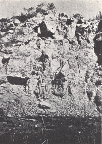 |
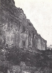
FIG. 1. Peebles dolomite (Guelph)
overlain
by the Greenfield dolomite (Cayugan)
with
the Olentangy and Chattanooga
above. Basic
Products Quarry east of
Peebles, Ohio. The
Peebles, unknown in
outcrop in Kentucky
except near the
Ohio River in Lewis County, is
the upper
part of the important Irvine pay
("Corniferous") of Estill County. The
Peebles
here in outcrop is quite petroliferous. |
FIG. 2. Lilley
dolomite (= Louisville
limestone) with the Peebles above. Quarry
1 mile
east of Lynx and about 10 miles east
of West Union, Adams County, Ohio.
The Lilley is also an important reservoir
rock comprising the lower part
of the
"Corniferous" of the Irvine pool. |
 |
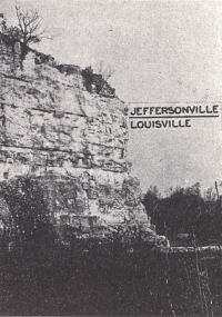 |
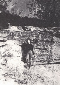
FIG. 3. Disconformable
contact of the
Louisville and Jeffersonville limestones,
Louisville. The upper few feet of the
Louisville are cherty and quite
fossiliferous
with abundant Halysites
catenularia,
Strombodes striatus,
Cladopora
reticulata, etc. |
FIG. 4.
Disconformable contact of the
Louisville and Jeffersonville limestones,
Louisville, Kentucky. |
|
 |
|
Plate VIII.—Silurian sections |
Footnotes
1 Belfast.—The name was applied by Foerste (1896) to 3 to 6 feet of bluish
argillaceous and arenaceous, usually massive limestone underlying the
Brassfield in Highland County, Ohio. It is known as far south as Hillsboro in
Fleming County, Kentucky. The same writer has since (1931) shown it to be a
local phase of the basal Brassfield.
2 Indian Fields.—The name was given by Foerste (1906) to the succession of beds
included in the Plum Creek and Oldham formations. In 1931 he dropped the term
and referred the Plum Creek shale to the Medinan.
3 This is another sandstone as the Big Six occupies a lower stratigraphic
position.