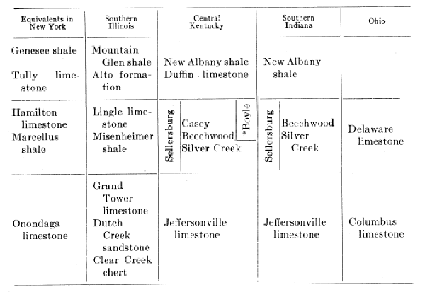
(After Savage, 1931, p. 218, with minor
additions.)
* Kiddville layer at base.
|
|
|
(After Savage, 1931, p. 218, with minor
additions.) |
The Devonian outcrop is mainly along the outer edge of the Blue Grass and adjoining Knobs, but occurs also in the Cumberland River region of southern Kentucky and along Pine Mountain. In these two localities it is represented only by the Black shale. The Devonian overlap across older beds toward the crest of the Cincinnati arch is noteworthy. In the southern Blue Grass the overlap is by the Boyle limestone and equivalent, rather than the Ohio shale, but it, in turn, is locally cut through by the latter.
Jeffersonville limestone (Kindle, 1899).-- The Jeffersonville is a grey, more or less coarsely crystalline heavy-bedded dolomitic limestone with some cherty beds. Simple and compound corals occur in great profusion and overlie the Mid-Silurian Louisville limestone, similarly rich in corals. Stromatopora is also abundant. Butts (1915) gave the following section:
Section of Jeffersonville Limestone at the Whirlpool 1 Mile West of
Jeffersonville,
Indiana. Partly compiled
Feet
5. Limestone, massive, rather coarse-grained, light gray, a little black chert
locally. Whitish and shelly on weathering. Exfoliates diagonally to the bedding.
Spirifer acuminatus about in top. Stropheodonta hemispherica, abundant and
conspicuous, bryozoa abundant, includes bryozoan and Nucleocrinus subzones of
authors. Spirifer acuminatus zone.............................. 9±
4. Limestone, siliceous, cherty, bluish-gray, fine grained, very hard. Spirifer
gregarius, very abundant. Favosites hemisphericus, Turbo shumardiy etc.
Spirifer
gregarius zone.................... 2
3. Limestone, 6 inches to 1 foot layers, medium coarse grained, light pinkish,
bluish, or brownish gray. In places largely made up of Stromatopora.................................................
7
2. Limestone, medium thick-bedded, very coarse crystalline, brownish in part.
Crowded with corals. Coral layer..................... 7
Certainly Jeffersonville........................................... 25
1. Limestone, covered with water, not identified..................... 3
The formation has a maximum known thickness of 30 feet and is locally missing in Jefferson County. It is known in outcrop only in Jefferson and Oldham counties. To the south it is overlapped by the Beechwood member of the Sellersburg which rests on the Louisville.
The Jeffersonville limestone corresponds in age with some part of the Onondaga of New York. Its relationship to the Grand Tower (Onondaga) of Illinois is indicated by Savage (1931, p. 220).
"In Kentucky the layers containing very numerous shells of Spirifer gregarius occur near the base of the Jeffersonville limestone, while in Illinois this Spirifer gregarius zone is found at the top of the Grand Tower limestone. In Kentucky the strata containing Spirifer acuminatus are present in the Jeffersonville limestone a number of feet above the Spirifer gregarius zone, while in Illinois the horizon of upper Jeffersonville strata containing Spirifer acuminatus is absent, but there are present in Illinois a thickness of 40 or more feet of Grand Tower (Onondaga) strata below the coral reef zone which are entirely absent in Kentucky."
He also mentioned (1930a, p. 89) the presence in Illinois of "100 or more feet of Onondaga (Grand Tower) limestone belonging below the oldest of the Onondaga rocks present in Kentucky."
The fauna is conspicuously a coral one. Among the more common fossils are (Savage, 1930a):
|
Acrophyllum clarki Aulacophyllum mutabile Aulacophyllum cf. unguloideum Cyathophyllum coalitum Cyathophyllum exiguum Cyathophyllum greeni Cyathophyllum multigemmatum Cyathophyllum rugosum Cystiphyllum theissi Diphyphyllum bellis Eridophyllum arundinaceum Favosites amplexissimus Favosites cariosus Favosites convexus Favosites emmonsi Favosites fustiformis Favosites hemispherica Favosites limitaris Favosites radiciformis Favosites ramulosus Favosites quercus Michelinia cylindrica Zaphrentis compressa Zaphrentis gigantea |
Zaphrentis linneyi Zaphrentis prolifica Zaphrentis ungula Zaphrentis sp. Atrypa reticularis Camarotoechia sappho Camarotoechia tethys Pentamerella cf. arata Pholidostrophia iowensis Productella spinulicosta Spirifer acuminatus (see S. acuminatus zone) Spirifer gregarius (see S. gregarius zone) Stropheodonta demissa Stropheodonta hemispherica Stropheodonta inequistriata Conocardium cuneus Platyceras cf. ventricosum Pleuronotus decewi Turbo shumardi Phacops sp. Proetus sp. |
SELLERSBURG LIMESTONE (Kindle, 1899).—This is the Delaware limestone of Ohio
and is divided into the Silver Creek and Beech wood members. To these Savage
(1930) added an upper Casey limestone member.
Silver Creek limestone (Siebenthal, 1901).—In Kentucky this member has been recognized only in a narrow belt bordering the Ohio River in, and for a short distance north of, Louisville. It is a thick-bedded dark grey fine-grained low to high magnesian, siliceous, and aluminous limestone. Magnesium carbonate ranges from 16 to 35 per cent. Bands of chert weather to a chalky white. Considerable calcareous shale occurs at some levels. A thickness of 16 feet occurs on the north bank of the Ohio near the Falls, but other observed thicknesses in Kentucky do not exceed 8 to 10 feet. It is moderately fossiliferous.
Beechwood limestone (Butts, 1915).—The Beechwood can be recognized in its typical lithologic and faunal character at only a few points south of northern Bullitt County. Among them is the type locality of the Casey limestone near Kidd's store in southwestern Casey County. It consists of grey, rather thick-bedded coarse-grained crinoidal limestone below, finer grained and darker colored limestone in the upper part. Crinoid stem plates are exceedingly abundant. Maximum known thickness, 6 to 8 feet. Rounded black phosphatic nodules occur in the lower few inches. It is moderately fossiliferous.
Casey limestone (Savage, 1930a).—Savage defined the formation as the limestone between the Beechwood and the Duffin layer. The upper part is thick-bedded, grey, and rather fine-grained and contains numerous irregular masses of chert. This is underlain in many places by a thinner bedded, grey, and somewhat sandy limestone, 2 or more feet thick in the lower part of which there is a 2-inch band crowded with Ambocoelia umbonata. Overlying the Beechwood, it is the youngest recognized Hamilton in the state. The same horizon is recognized to the east in the upper part of Foerste's Boyle limestone throughout much of its extent.
The Sellersburg contains a considerable fauna, of which the following are some of the more common and distinctive forms: (Butts, 1915, and Savage, 1930a)
|
Cystiphyllum americanum *Favosites emmonsi Favosites goodwini *Heliophyllum halli Heliophyllum juvene
Ambocoelia umbonata
|
*Spirifer audaculus *Spirifer divaricatus Spirifer fornacula Spirifer hobbsi Spirifer oweni *Spirifer segmentum *Spirifer varicosus Stropheodonta concava *Stropheodonta demissa *Stropheodonta perplana Tropidoleptus carinatus
Clinopistha antiqua
Loxonema hydraulicum
Gomphoceras turbiniforme Phacops rana |
* These forms also present in the Jeffersonville.
Boyle limestone1 (Foerste, 1906).—South of Bullitt County in central Kentucky the Devonian limestone does not present the lithology or faunal character of either the Jeffersonville or Sellersburg. Its most characteristic fossils are regarded as Hamilton and include (Savage 1930a, p. 14):
|
Cystiphyllum americanum Heliophyllum halli Ambocoelia umbonata Athyris spiriferoides Camarotoechia sappho Pentamerella pavilionensis Spirifer granulosus Tropidoleptus carinatus |
But species suggestive of the Onondaga are present. For this limestone of
uncertain affiliation Foerste proposed the name "Boyle." As defined, it includes
massive medium- to fine-grained cherty dolomitic limestone at the top (Casey
limestone of Savage), with thinner and more evenly bedded dolomitic limestone
below which contains little chert. It rests unconformably on Silurian or
Ordovician and in most places disconformably underlies the Duffin layer. Both
the Boyle limestone and Duffin layer are locally missing, and the New Albany
(Ohio) rests on the Silurian and Ordovician. Such areas include:
Many of these localities are structurally high on the Arch, but the occurrence of the limestone in Boyle County is along the axis. It is known to be locally absent underground in the Irvine oil field of Estill County (McFarlan, 1938d) and the region immediately to the east (Freeman, 1941) though present in outcrop only a few miles to the west.
A thickness of 42 feet is attained in Casey County but the usual range is 10 to 15 feet.
Kiddville layer (Foerste, 1906).—A layer at the base of the Boyle lime-stone characterized by the presence of abundant fish remains in the form of spines, plates, and teeth associated with small black phosphatic nodules. The rock varies from the usual dolomitic limestone to sandy limestone and in places a thin sandstone. The thickness of the more characteristic part of this zone is only a few inches, but fish plates are also found in the rock immediately above.
The recognition of what is apparently the Kiddville layer at the base of the Beechwood member of the Sellersburg (L. B. Freeman) west of the Arch establishes the correlation of the Boyle limestone.
Duffin layer (Foerste, 1906).—This is a massive sandy grey dolomitic limestone which on weathering gives a pseudobrecciated appearance. Locally a little black shale is found below, and locally similar beds are found interbedded with the basal 9 to 15 feet of the shale. For this reason Savage (1930a) regarded it as the basal member of the New Albany (Ohio) rather than a part of the Boyle.
Fossils from this bed were given by Savage (1930a, p. 17):
(a) From interbedded lenses of dolomite 8 to 10 feet above the base of the New Albany near Irvine—Ambocoelia cf. umbonata, Chonetes cf. mucronatus, Gypidula cf. comis, Hypothyris cuboides, Leiorhynchus quadri-costatus, Leiorhynchus sp., Martinia subumbona, Spirifer cf. pennatus var. tulliensis, and Spirifer sp.
(b) From the Duffin layer 1 to 2 miles west of Clay City—Ambocoelia cf. umbonata, Asterolepis sp., Camarotoechia cf. sappho, Camarotoechia sp., Hypothyris cf. cuboides and Strophalosia sp.
He correlated the Duffin with the Tully of New York.
New Albany-Chattanooga-Ohio.—Succeeding the Devonian limestones is a succession of black shales which in the western area of outcrop has been known as the New Albany (Borden, 1874), along the eastern belt of Knobs as the Ohio shale (Andrews, 1870), and in southern and southeastern Kentucky usually as the Chattanooga shale (Hayes, 1891).
The Ohio is a black fissile shale which includes locally layers of green shale and in the bottom in places “thin laminae or layers of sandstone and in other places thin calcareous layers” (Butts, 1922, p. 6). These have been mentioned in connection with the Duffin layer. At Vanceburg the lower 30 feet of shale carry limestone concretions up to 2½ to 3 feet in diameter. This zone has been differentiated in Ohio as the Huron shale. When freshly fractured, the rock seems without lamination but this structure is brought out by weathering. The rock consists of clay, fine particles of quartz, pyrite, and a few other minerals and black organic matter. Few fossils are present. Spore cases (Sporangites) are relatively common. Petrified wood (Callixylon newberryi) is found locally and "six other species (plants) have been collected from the nodules at the top of the Black shale ½ mile west of Junction City" (Butts, 1922, p. 10). Invertebrate fossils include mainly a number of inarticulate brachiopods and conodonts. Fish remains have been found in Ohio.
Correlation.—The fauna listed from the Duffin layer dates the beginning of deposition of black shale in Kentucky as Tully. The age and subdivisions of the shale has been an unsettled problem for years, principally because of the scarcity of fossils and the indecisive value of most of those found. At Vanceburg and vicinity the Ohio shale with a thickness of 300 feet is overlain by the Bedford and Berea and in turn by the very similar Sunbury black shale. Southward the Berea wedges out, followed by the Bedford, and in the vicinity of Irvine 95 feet of Ohio shale is separated from 3 feet of Sunbury by 18 inches of Bedford. The latter is not known farther south, giving rise to uncertainty of the upper Devonian or lower Mississippian age of all or part of the Black shale in the rest of the state. Numerous contributions to the solution of this problem have been made:
(A) Bassler (1932, p. 133) states, "In northern Tennessee the lower part of the Black shale is separated from the upper by a well-marked unconformity, and, moreover, contains Devonian fossils. This Devonian part of the shale does not apparently extend southward over the Nashville Dome to any great distance." The Chattanooga shale which is widespread in the Nashville Basin while originally assigned an upper Devonian age by Hayes (1890) was later referred by Ulrich to the Mississippian. "Dr. Ulrich and the writer (Bassler, 1932, p. 137) found that of more than 50 species from the black shales of Alabama and Tennessee not one was identical with an equally large number of species from the Devonian black shales of New York, although many of them are identical with those found in the Mississippian shales of northern Ohio."
(B) Swartz (1924, 1926, 1927, 1929) divided the Chattanooga of eastern Tennessee into three members:
(3) Big Stone Gap member.
(2) Olinger member—a pure to sandy grey shale.
(1) Cumberland Gap member—a very black shale.
The Olinger carries a Bedford-Berea fauna, and interfingers with the upper Cumberland Gap shale. The Chattanooga shale thus, with the possible exception of the lower Cumberland Gap member, is Mississippian throughout. These observations are applicable to the southeastern Kentucky exposures.
(C) Savage (1930a) recognized the Tully age of the Duffin layer which is persistent on both sides of the Arch and dates the beginning of deposition of black shale. He concluded that inasmuch as at no place in the state is there evidence of an hiatus within this formation, the New Albany, (including Ohio) formation in Kentucky is thought to represent a continuous succession of deposition during some part of Tully and Genesee time.
(D) In a later paper Savage and Sutton (1931a) called attention to a Kinderhook fauna in a cherty zone 20 feet above the base of the Black shale, where it has a thickness of 27½ feet in the southeastern corner of the Scottsville quadrangle (Allen County). This Mississippian part they regard as a local development.
(E) Pohl (1930) divided the Black shale of Tennessee into three units—the upper two of Mississippian age, and correlated with the Cleveland and Sunbury shales of Ohio. They constitute the bulk of the Black shale in central Tennessee and in Allen County, Kentucky. The third division, his Trousdale shale, only locally developed, is correlated with the Genesee-Portage. Savage and Sutton, though, question the Mississippian age of the Cleveland and regard it as more probably Devonian.
(F) Huddle (1933,1934) in his work on the New Albany shale of Indiana recognized the Devonian age of the shale up to within 5 to 10 feet of the top of the formation, basing his determination on:
(a) the presence of Callixylon newberryi this high in the section.
(b) a Devonian brachiopod fauna 5 feet below the top of the formation from 2 miles north of Rockford, Indiana. The fauna included Rhipidomella vanuxemi newalbanensis, Chonetes yandellanus seymourensis, Camarotoechia eximia, Platyrachella cf. macbridei, Delthyris sp., Orthotetes, sp., Platyceras sp.
With this fauna are associated the species of his upper conodont fauna, of which, from a total of 81 species, 64 are new, eight are known from the Chattanooga, six from the Portage, two from the Genesee and Portage, and one from the Woodford (Devonian(?) of central-southern, and southeastern Oklahoma). A sharks tooth, Cladodus springeri, from these same beds is known from the Kinderhook. Evidence concerning this upper 5- to 10-foot zone is indefinite with definite evidence of Mississippian age still lacking.
(G) Campbell (1937) concluded:
(1) The New Albany shale at its type area (New Albany, Indiana) represents deposition from Genesee until later than Sunbury.
(2) Four zones were recognized:
(d) Lingula melie zone. Includes a layer of phosphatic nodules. This represents the interval from the top of the Cleveland to the top of the Sunbury and probably later.
(c) Silicified Callixylon newberryi zone.
(b) Barriosella subspatulata zone. Interbedded fissile black shale and grey argillaceous shale. In a grey shale at the base Spathiocaris sp. occurs in addition to Barriosella. This is correlated with the Olentangy of Ohio.
(a) Schizobolus truncatus zone.
(3) All of the zones occur in all four states (Ohio, Indiana, Kentucky, and Tennessee) except the Schizobolus zone, which is absent from Ohio and central Tennessee.
"It is apparently conceded by all that the part of the Ohio (or Chattanooga) shale carrying Schizobolus, as herein described, is of Genesee age. It is believed by Ulrich, however, . . . that the Genesee representative in Ohio and Kentucky is confined to detached areas" (Butts, 1922, p. 11).
(4) The Maury shale in its type area in Tennessee is younger than the layer of phosphatic nodules (Maury) of Kentucky.
(H) An interesting interpretation of the Black shale problem has been advanced by Klepser (1937) quoted by Stockdale (1939) in which the Chattanooga, Maury, New Providence, and Fort Payne formations are regarded as time transgressing lithologic types formed as the result of a southward transgressing sea. The Chattanooga ranges in age from Kinderhook in the north to Keokuk in the south (central Tennessee).
Quoting from H. J. Klepser (1937):
"One cannot help being impressed by the progressive absence of the lower beds of Mississippian age in a southward direction, and at the same time by the apparent conformity existing between the individual formations throughout the Eastern Highland Rim. More specifically, the New Providence formation, of Fern Glen or Lower Burlington age, thins from 50 feet in Pulaski County, Kentucky, to 2 feet in the vicinity of the Tennessee state line. The basal two feet has a more definite green color, everywhere contains phosphate nodules and grades into the black shale below. This portion, which alone is represented between the Chattanooga and the Fort Payne southward from central Cumberland County, Kentucky, is called the Maury green shale, but is not separated as a distinct unit in Kentucky where the New Providence is present. The Fort Payne formation conformably overlies the New Providence in southern Kentucky, yet south of there in Tennessee where the New Providence is missing, the Fort Payne apparently conformably succeeds the Maury shale. In northern Tennessee where the Fort Payne is 250 feet thick, it contains upper Burlington and Keokuk fossils, but southward the Burlington portion thins to the vicinity of southern Overton County, where Keokuk forms are found directly above the Maury. Southward the formation continues to thin and finally in the southern part of the State, where it is about 50 feet, represents only the upper portion of the Fort Payne of northern Tennessee and Kentucky. Since the Maury is conformably overlain by formations of various ages, ranging from Fern Glen to upper Keokuk, it follows therefore, that the Maury, and the Chattanooga which everywhere grades up into the Maury, must be time transgressing units, representing the basal shore phase of a sea advancing southward.2
"The Maury and Chattanooga, thus are merely shore phases represented northward by the more normal sediments of the New Providence and Fort Payne formations. For example, while the New Providence muds were accumulating some distance from the land, black muds and green muds with phosphate nodules were forming along the shore. As the sea encroached farther on the land, the black muds were deposited on the old erosion surface, the green muds overlapped the black deposits and the New Providence clays overlapped the green muds. This process continued at least throughout New Providence and Fort Payne time, and as a result two thin but persistent formations, the Chattanooga and Maury, were formed. These two formations, therefore, are not time units, but merely lithologic deposits resulting from a particular environment. A number of years ago Grabau (1906) introduced this same hypothesis of the origin of the Chattanooga shale, but he did not present detailed faunal evidence to support his views, and his theory was apparently not given much serious thought. . . .
"The advocates of a Mississippian age for the Chattanooga shale have, with few exceptions, stated that the shale is of Kinderhookian age. As the evidence to be introduced in this dissertation will attempt to show, however, the Chattanooga shale of east-central Tennessee is largely post-Kinderhookian, or in other words almost if not entirely of Osagian age. In addition, it is highly probable that southward in Alabama it may be of a younger age, Warsaw and possibly even St. Louis."
| PLATE IX | |
 |
 |
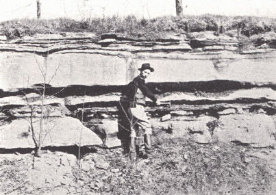
| FIG. 1. Duffin layer,
dolomitic limestone interbedded with black shale, about 1 mile southeast of Trap, Clark County. Savage includes these beds in the basal Ohio rather than with the Boyle limestone below. At this particular locality the Boyle limestone is missing and the Duffin layer rests on the lower Crab Orchard. |
FIG. 2. Massive
Duffin limestone about 1 mile north of Cartersville, Garrard County. |
 |
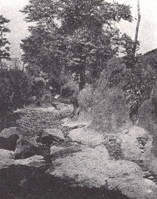
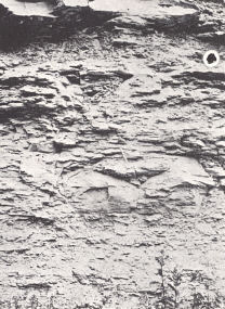
 |
| FIG. 3.
Characteristically cherty Casey limestone 2 to 3 miles southeast of Trap, Estill County. |
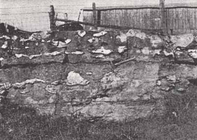
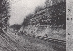
FIG. 4. Louisville and
Nashville Railroad cut near Agawam Station, 7 miles southeast of Winchester. The Liberty formation (L.-perhaps also including the Whitewater) is overlain by the Brassfield (Br.) and in turn by the Ohio (0.) shale. A few miles to the east the Boyle limestone wedges in between the Brassfield and Ohio. Higher on the Cincinnati arch the Boyle limestone and Ohio shale overlap onto the Maysville. |
| Plate X | |
 |
|
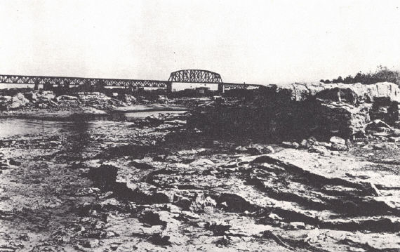
| FIG. 1. Falls of the Ohio at Louisville at low water exposing the Jeffersonville limestone. | |
 |
 |
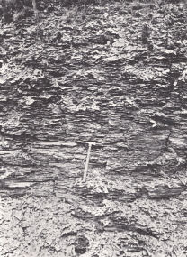
| FIG. 2. Ohio shale. Road cut
between Winchester and Clay City in western Powell County. |
FIG. 3. New Providence shale.
Railroad cut near Glen Cairn Station about a mile southeast of Natural Bridge, Powell County. |
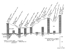 |
| Plate XI.—Devonian sections |
Footnotes
1 As indicated on p. 39 Ballard has recognized the Helderberg in the unexposed
section in Wolfe County and eastward, overlapped to the west by the
Mid-Devonian. The recent work of Freeman has shown it to be present, and
similarly overlapped by the Mid-Devonian in the Western Coal Field (see pl.
XXXIII).
2 Not italicized in original.