|
|
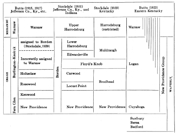
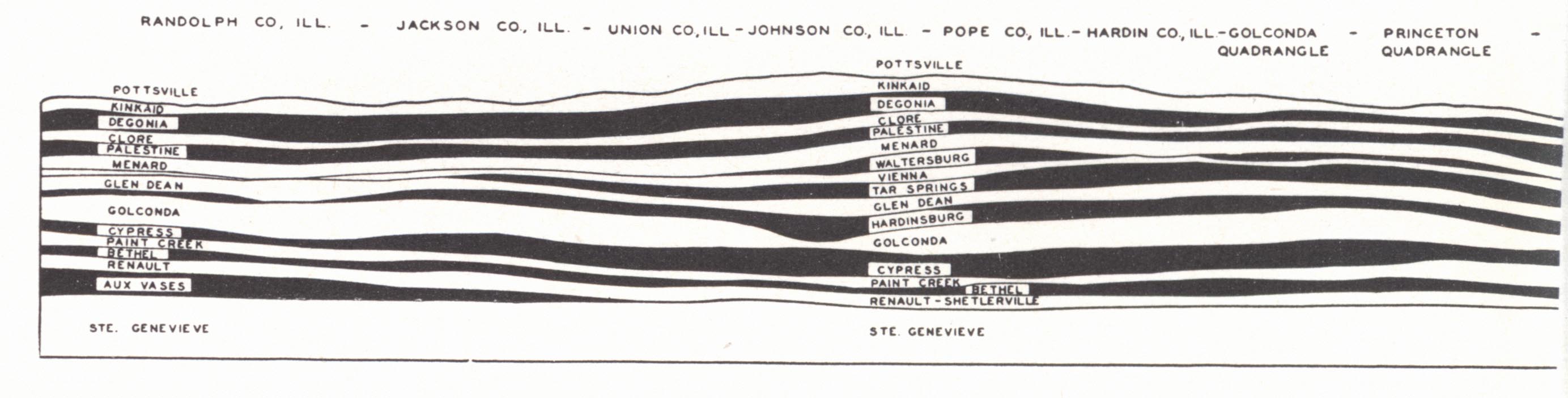
| (Correlations after Stockdale, 1939.) |
The lower Mississippian outcrops in the Knobs and vicinity, and in the Cumberland River region of south central Kentucky. The Meramec and Chester occupy the region of the Mississippian Plateaus. The whole section is again brought to the surface in the Pine Mountain overthrust and on the eastern flank of Cumberland Mountain in Virginia and Tennessee.
KINDERHOOK
Bedford shale (Newberry, 1870).--From Bedford, Cuyahoga County, Ohio, where, 75 feet thick, it occupies the interval between the Berea sandstone and Cleveland shale. Twenhofel (1931, p. 167) used the term "Chattanoogan" for the Chattanooga, Bedford, Berea, and Sunbury, and regarded the Kinderhook as absent in Kentucky unless "represented in the basal beds of the New Providence." Weller (1931) classified the Bedford, Berea, and Sunbury as Kinderhook.
The Bedford in the type area is a soft laminated blue clay shale but in Kentucky is commonly silty and involves some interbedded siltstone and greenish grey sandstone. From Vanceburg, where it has a thickness of slightly more than 100 feet, the Bedford thins southward to 1½ feet near Irvine (Butts, 1922), and it has been recognized by Stockdale (1939) only a few inches thick in southeastern Clark, southern Montgomery, and western and northern Powell counties. Foerste (1909d) identified a Bedford fauna from similarly a few inches of the clay near Indian Fields, Clark County. In southeastern Montgomery County thicknesses of 5 inches to 12 feet have been measured, 14 feet at Salt Lick in Bath County, and about 35 feet in Fleming County. The first hint of the appearance of the Berea in the section to the north is in southwestern Lewis County where thin ripple-marked fine-grained sandstone layers about an inch thick are interbedded in the upper part of the Bedford. East of Vanceburg both in outcrop and under cover, the Ohio-Sunbury interval is occupied chiefly by sandstone which seems to involve both the Bedford and Berea.
Butts (1922) listed the following fauna, including his collections and those of Foerste:
|
Ambocoelia norwoodi* Very abundant Camarotoechia sp. Chonetes sp.? Cryptonella-like brachiopod*? Lingula irvinensis Orbiculoidea, 2 sp. Orthotetes (Schuchertella) herricki* Orthotetes (Schuchertella) morsei Rhipidomella sp.*? Cypricardella cf. reservatus* Figured by Herrick as Microdon bellistriatus |
Macrodon irvinensis.* Same as Bedford shale form identified as M. hamiltonae Nuculana, 2 sp.* One, small, figured by Herrick as N. diversa Bellerophon, 2 sp. Loxonema* Same as figured by Herrick as L. delphicola? Pleurotomaria*? Tropidodiscus aff. cyrtolites* |
* Identified with Bedford shale species in the area of its typical development in Ohio.
*? Doubtfully identified with these species.
The fauna is closely related to the Hamilton and because of this aspect has been regarded by some as Devonian.
Berea sandstone (Newberry, 1870).—The Berea was described as the Berea grit, since the sandstone has been used extensively for grindstones and whetstones.
It outcrops along the Ohio River in eastern Kentucky, but in its characteristic development extends only a few miles to the south. Under cover it is recognized in drill records to the east and is an important producer of gas in Martin and Lawrence counties. It is a thick-bedded fine-grained rather loosely cemented and soft grey sandstone; when weathered, iron-stained. The grains are subangular and the surfaces of many beds are beautifully ripple marked. These rippled surfaces are rather characteristic. No fossils are known.
Sunbury Shale (Hicks, 1878).—The Sunbury is a black fissile shale of the same general character as the Ohio. In outcrop at Vanceburg it is 16 feet thick but thins southward to 3 feet at Irvine where it is separated from the Ohio by the thinned edge of the Bedford. Farther south there is difficulty in separating these shales.
The principal fossils include Lingula melie and Orbiculoidea newberryi (identified 0. herzeri by Hall and Clarke). Fish remains are known in Ohio, less commonly in Kentucky. In Ohio a rich conodont fauna is present and regarded as characteristic. The presence of these same conodont species in the Chattanooga is one reason for Ulrich's correlation of it with the Sunbury. The correlation of the Sunbury and other black shales is discussed under the Ohio shale (pp. 51-53),
These three formations constitute the basal Waverly of Ohio.
OSAGE
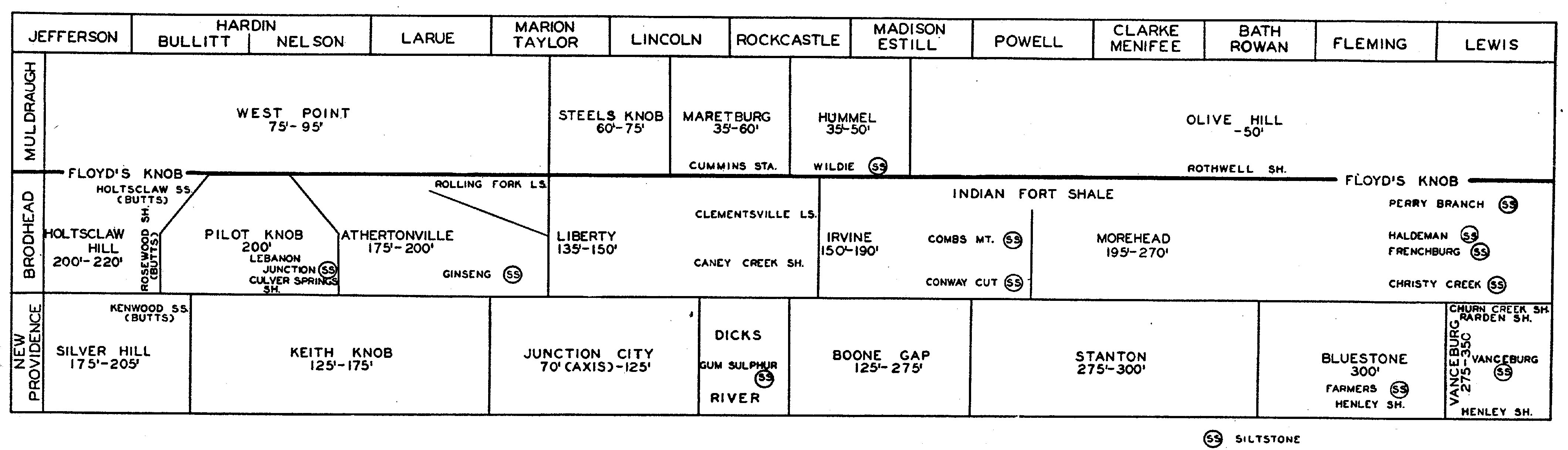
The rocks of the Osage begin with the New Providence at the base and extend up to the Warsaw (Harrodsburg limestone of Indiana). As such, they constitute the post-Sunbury portion of the Waverly of Ohio, have been referred to as the New Providence group by Butts (1922) in eastern Kentucky, and constitute Stockdale's (1931) Borden group. An outline of the classification of these rocks, including the more recent revision by Stockdale (1939), is given on p. 57.
WAVERLY (Mather, 1838).—The Waverly group in Ohio and eastern Kentucky is about the equivalent of the Borden of Indiana but includes in addition the Bedford, Berea, and Sunbury at the base. In northeastern Kentucky and Ohio, also, the uppermost Borden rocks are unrepresented (Stockdale, 1939).
Cuyahoga (Neuberry, 1870, and Hyde, 1915).—This is a shale-siltstone formation of the lower Waverly. Stockdale has shown it to be the equivalent of the New Providence of Jefferson County and it is described under that heading.
Logan formation (Andrews, 1870 and Hyde, 1915).—This is the upper Waverly of eastern Kentucky and finds its equivalent in the MacCrady shale = upper Price sandstone of Virginia. It was regarded by Butts (1922) as the upper part of his New Providence group, which in turn he correlated with the New Providence formation of Jefferson County. Stockdale's (1939) revision, assigning it to the Burlington-Keokuk, has been indicated in an earlier page and in the correlation charts (pl. XVI). As such, it is his Brodhead, Floyd's Knob, and Muldraugh formations described below. Because of unconformity much of the formation is missing in the Ohio River counties. Spirifer milleranus has been regarded as rather distinctive.
Butts (1922) recognized an upper member, the Morris Mountain shale member (from Morris Mountain, Powell County). It was described as dominantly shale with some sandstone and limestone or calcareous fossiliferous material with a thickness of normally 50 to 60 feet, but ranging up to 100 feet. It was recognized from Berea to Lewis County and throughout this area was said to carry a New Providence fauna.
Stockdale (1939) has identified the Floyd's Knob formation in the middle of the Morris Mountain shale and this member is thus shown to be composed of his Indian Fort shale member of the Brodhead, the Floyd's Knob, and Rothwell shale member at the base of the Muldraugh formation. The post-New Providence age of the Logan has already been indicated.
Fort Payne (Hayes, 1891).—According to Butts (1922) the Fort Payne throughout its area of outcrop in southern Kentucky is chiefly a dark to grey sometimes greenish stiff silty shale of the type found in the Rosewood, cleaving diagonal to the bedding. Associated with it is limestone varying in quantity but constituting about one-third (sometimes more than half) of the formation. The limestone varies from thick-bedded coarse-grained light to bluish grey crinoidal, to medium-bedded fine-grained unfossiliferous and siliceous. Chert is commonly present as nodules and beds, or if disseminated, it appears on weathering as nodules in the residual soil. The rock is unlike either the typical Fort Payne of Alabama or Keokuk of Iowa. Butts assigned a thickness of 250 feet (base of Warsaw placed ±50 feet too low, hence ±300 feet) in Jefferson County to 200 feet in Barren and Wayne counties to not over 75 feet in Pulaski, Lincoln, and Boyle counties. Fifteen feet of thin-bedded chert represents the formation at Cumberland Gap.
Klepser (1937) recognized a Greasy Creek facies from the creek of that name in central Russell County. It is described as varying from silty shale to grey massive siltstone, which is the prevailing type, to crinoidal limestone. Abrupt and frequent lateral change is the rule. The massive crinoidal limestones mark bioherms developed in quiet waters between points of distributary discharge on a delta front. They are lenticular and not known north of the vicinity of Lebanon, Kentucky.
The name Fort Payne is used only in the southern area of outcrop and finds its equivalent in the Logan (Brodhead-Muldraugh) farther north. It includes in southern Kentucky and northern Tennessee strata which have in the past been referred to the New Providence. It is a lithologic unit progressively younger to the south, and constitutes one of Stockdale's time-transgressing units (1939). The contact with the overlying Warsaw is transitional.
New Providence (Borden, 1874).—from New Providence (now known as Borden), Clark County, Indiana where it was defined as constituting the lower 80 to 126 feet of the Knobstone group. The New Providence rests on the New Albany shale in the western area of outcrop, and Chattanooga shale to the south, but from Irvine and vicinity northward it (Cuyahoga) rests on the differentiated Sunbury black shale. The fauna is that of the Fern Glen-Burlington. As used by Butts (1922) the New Providence was regarded as the equivalent of the Waverly, excluding the Bedford, Berea, and Sunbury, which are unknown in the southern and western Knobs. In his recent work, though, Stockdale (1939) has shown the Keokuk age of the upper Waverly (Logan) and correlated the New Providence with the Cuyahoga. The formation thins toward the axis of the Arch. It also dwindles southward across Kentucky and disappears near the Tennessee line. "New Providence" strata heretofore recognized in Tennessee belong to the Brodhead formation (Stockdale, 1939).
It is characteristically a soft grey to green clay shale which weathers into plastic clay. In northeastern Kentucky minor amounts of red and maroon shale are included. In many places lamination and fissility are lacking, and where fresh the shale breaks down with conchoidal fracture into irregular pieces. Gullied slopes are common where vegetation is absent. A striking feature of the typical New Providence, and less so of the Cuyahoga, is the development of heavy brittle masses of rock containing much iron and other carbonates in the form of flattened concretions ("kidney boulders," "ironstones," and "iron concretions"), lenses, and layers up to 18 inches thick. These break down into brittle, yellow to brown chips and are rather characteristic of the lower part of the formation.
Limestone lenses, often highly fossiliferous, are locally developed. Button Mould Knob, 12 miles south of Louisville in northern Bullitt County, is a famous fossil locality. Similarly siltstone and sandstone facies are locally present. To the north and east the formation becomes more sandy but is still a dominantly shale formation and is known under the name Cuyahoga (Newberry, 1870). Taonurus is particularly abundant on the bedding surfaces of the siltstones of the New Providence, but ranges up through the entire Borden.
Throughout the area of outcrop, except to the northeast where the Bedford-Berea-Sunbury unit intervenes, the New Providence rests on the Ohio-New Albany shale with an intervening foot or two of clay-shale bearing phosphatic nodules (Maury1). There is no evidence of unconformity. In southern Indiana the thin Rockford limestone is present below.2 The top of the formation is commonly transitional with overlying beds, and it is difficult to draw a satisfactory boundary. The soft olive to blue-grey clay-shales with abundant ferruginous concretions give way to a more sandy and less plastic material. Characteristic small worm markings appear in the rocks above. Fossils are not common enough to be of much use. The lower Logan with its massive siltstones in the northeast contrasts with the silty shales of the Cuyahoga below.
|
|
|
PLATE XII |
A number of facies and members of the New Providence have been recognized by Stockdale (1939):
1. The Silver Hill facies of southern Jefferson and northern Bullitt counties is the typical soft green to grey clay-shale, plastic when wet, with abundant concretions and ferruginous layers. Thickness, 205 to 175 feet (south). Locally, as at Button Mould Knob, lenses of highly fossiliferous and somewhat ferruginous limestone occur. The shale itself is devoid of fossils. The Kenwood sandstone (siltstone) member (Butts, 1922, used as a separate formation overlying the New Providence) at the top is 40 feet thick in the Knobs south of Louisville. In its limited area of development it is a massive grey to brown fine-grained sandstone with subordinate shale partings. To the south the sandstone gives way to shale and in Bullitt County cannot be separated from the Rosewood above.
2. The Keith Knob facies (developed in southern and southwestern Bullitt, Nelson, Hardin, and Larue counties) contrasts with the preceding in the absence of the Kenwood sandstone member, in the presence of even beds of siltstone within the lower part, and in the absence of fossiliferous limestone lenses. The upper boundary is difficult to establish other than by the change in type of shale. The uppermost iron band or bed of concretions is regarded as reasonably satisfactory for this purpose. Thickness, 175 to 125 feet (south). Fossils are few, but gullied shale slopes often show fossils washed down from a fossiliferous shale zone above (Brodhead).
3. The Junction City facies3 (developed in the area south of the Blue Grass from Marion to Lincoln County) is typical New Providence soft clay shale at the base grading into the more silty and sandy shales of the Brodhead formation above. The thickness varies from 70 to 125 feet with the minimum along the axis of the Arch.
4. The Dicks River facies (developed in eastern Lincoln and Rockcastle counties) section consists of a more or less massive 40-foot cliff-forming siltstone (Gum Sulphur siltstone member) with up to 45 feet clay to silty shale below and 75 feet of typical New Providence clay-shale and ironstones above. To the west and northeast the middle siltstone member gradually gives way to shale. Average thickness, 125 feet.
5. The Boone Gap facies (developed in northern Rockcastle, southern Madison and Estill counties) is the usual clay shale with maroon patches in the lower part alternating with more resistant silty shale zones. Sporadic "ribs" of siltstone or brittle dense grey limestone occur. Ferruginous concretions are unusually large, irregular, and locally abundant. Thickness, 125 feet in Rockcastle County to 275 feet in northeastern Estill County. The upper contact is fairly well defined by the rather massive Conway Cut siltstone member of the Brodhead formation above.
6. Stanton facies (developed in Powell, southeastern Montgomery and southern Bath counties).—This is mainly clay-shale with reddish maroon and purple shale zones in the lower part4 and more silty shale above. The usual ferruginous concretions, ledges, and "ribs" are present. Thickness, 275 to 300 feet (northeast). A fairly prominent siltstone lens up to 15 feet thick with abundant Taonurus markings occurs about 75 feet below the top. The Clay City siltstone member is a ½- to 3-foot resistant calcareous siltstone in the lower 5 feet of the formation.
This is the southernmost occurrence of New Providence resting on the Bedford-Sunbury wedge, and the Maury shale is not present, nor is it in counties to the north.
7. Bluestone facies (developed in southeastern Bath, Rowan, Fleming, and southwestern Lewis counties).—This facies marks the introduction of even-bedded siltstone layers alternating with shale in the lower part, a feature more extensively developed farther north. Thickness, about 300 feet. The upper contact is marked by the prominent cliff-forming siltstone of the Christy Creek member of the Brodhead. The typical section includes:
(e) One hundred and thirty to 150 feet muddy siltstone, massive to shaly.
(d) Up to 50 feet shale free of siltstone.
(c) Thirty to 50 feet clay to silty shale with scattered siltstone layers—essentially the Stanton facies in character.
(b) Twenty-five to 45 feet even-bedded and -textured siltstone beds (freestone) with subordinate shale partings—the Farmers siltstone member, quarried at Farmers and vicinity. Taonurus common. This type of rock disappears within a few miles to the southwest and south. The normal thickness of layers is 1 to 2 feet, but ranges up to 5 feet. It represents a part of Orton's (1874) Buena Vista sandstone member.
(a) Henley Clay shale member (Hyde, 1915), up to 12 feet of soft green clay shale.
8. Vanceburg facies (Hyde, 1915—developed in Lewis County).—The characteristic feature is the preponderance of siltstone in smooth even beds alternating with the zones of shale for 200 feet or more above the base of the formation. This marks a northward expansion of the Farmers siltstone. In the rest of the 275- to 350-foot (northeast) section silty shale becomes more prominent at the expense of siltstone. Fossils are few except Taonurus and the curly worm marks. In the vicinity of Vanceburg the upper contact is one of transition with the more massive siltstone (Byers sandstone of the Logan of southern Ohio) of the Brodhead. To the northeast the more shaly upper New Providence makes a sharp contact.
Subdivisions recognized include:
(d) Churn Creek shale member (Hyde, 1915). An upper 75- to 100-foot zone of mainly argillaceous to silty shales.
(c) Rarden shale member (ibid.). A thin zone (8J feet at Vanceburg) of alternating red and grey clay shales.
(b) Vanceburg siltstone member (ibid., "Vanceburg sandstone")- A great succession of even-bedded siltstones with lesser amounts of intervening shales. This is the quarry rock. It is more or less E. Orton's (1874) Buena Vista sandstone member which was redefined by Hyde as constituting only the lower and massive ledge which was widely known as the "city ledge" because of its extensive use in Cincinnati. Stockdale finds a ±200-foot section of this quarry rock.
(a) Henley shale member (Hyde, 1915). Nine to 10 feet of soft green (including a little red) clay shale intervening between the Sunbury and first siltstone.
The Beaver Creek oil sand is the main oil producing zone in Wayne County where it also occurs in outcrop. It is a dense bluish limestone, weathering yellow, with locally drusy or cavernous quartz inclusions several inches in diameter. It has a thickness of one to 25 feet and occurs from 5 to 40 feet above the base of the formation. It was included by Klepser (1937) as a member of his Forbush Creek facies of the New Providence formation.
The New Providence formation ranges in thickness from 150 feet in Jefferson County to 350 feet at the Ohio River on the eastern side of the Arch, and a similar thickness is attained in Pine and Cumberland mountains. To the east it is represented in the Price formation of Virginia and the lower Pocono of West Virginia and Pennsylvania. The latter constitutes the subaerial part of a delta grading westward into the marine Cuyahoga and Logan and then into the New Providence-Keokuk foreset and bottomset beds in the southern and western areas of outcrop (Butts, 1922 and Twenhofel, 1931).
The New Providence is locally quite fossiliferous. A conspicuous form in eastern Kentucky is Taonurus caudigalli (the rooster tail fucoid). Associated with it are found similarly abundant reed-like impressions. Both are abundant in, and more or less restricted to, the siltstone and silty shale facies of both New Providence (Cuyahoga) and Logan. They thus gradually disappear to the south and west. The clay-shales usually have few fossils but in places the silty shales and siltstones show abundant external and internal moulds. To the west limestone lenses have a fauna rich in bryozoans and corals and locally in crinoids. Cyathaxonia cynodon and Rhipidomella oweni are rather distinctive. Ptychospira sexplicata, Spirifer vernonensis and S. fernglenensis are characteristic Fern Glen forms. Brachythyris suborbicularis and Echinoconchus alternatus are not known below the lower Burlington in the Mississippi Valley. Upper Burlington fossils are unknown. Schuchertella lens and Athyris hannibalensis in that same region are restricted to the Kinderhook, suggesting that the New Providence may range this low (Weller, 1931).
Brodhead formation (Stockdale, 1939).—The formation is defined as including the section between the New Providence below and the thin but persistent Floyd's Knob formation above. The thickness is more uniform than that of the New Providence and ranges from 135 to 140 feet in Pulaski and Casey counties to 220 feet in Jefferson County and 250 to 270 feet in Greenup County. It is correlated with the Burlington- Keokuk; includes Stockdale's Locust Point and Carwood formations of the Borden group in Indiana (1931), Butts' (1915, 1922) Rosewood shale and Holtsclaw sandstone of Jefferson County and vicinity, and the greater part of the Logan of eastern Kentucky.
The formation consists of silty shale, shaly siltstone, massive siltstone, and fine-grained sandstone with many regional variations. The shaly phases are more prominent in the lower part in the western belt of outcrop but from Rockcastle County north a prominent shale member (lower part of the Morris Mountain shale member of Butts) is developed in the upper part. The siltstones typically lack the even bedding of the Farmers and Vanceburg siltstone members of the New Providence and are often massive, but locally as in parts of Rowan, Menifee, and Powell counties such layers occur. The shales are silty, gritty, and brittle in contrast to those of the New Providence. A drab grey color prevails and the variegated colors are missing. In parts of Hardin, eastern Larue, and western Nelson counties limestone dominates the section.5
Faunally there is considerable contrast. Taonurus is not so persistent as in the New Providence and small curly worm marks are much more common. Fossils are more common, particularly in the eastern area, occurring in the siltstones. The fauna is regarded as having a Keokuk aspect with such forms as Dictyoclostus cf. crawfordsvillensis, Orthotetes keokuk, Pseudosyrinx gigas, Spirifer floydensis, S. logani, S. montgomeryensis, S. mortonanus and Syringothyris textus.
Facies and members recognized include (Stockdale, 1939):
1. Holtsclaw Hill facies (developed in southwestern Jefferson and northern Bullitt and Hardin counties).—The section consists of 200 to 220 feet of unevenly fissile and silty shale grading upward into a massive bluff-forming siltstone containing much clay as binder. The lowest shales are argillaceous, much like those of the New Providence, but the contact is well marked by the fine-grained sandstones of the Kenwood member of the New Providence. Butts (1915 and 1917) applied the name Holtsclaw sandstone6 to the upper 24 feet of massive rock in which he found Orthotetes keokuk, Syringothyris textus, Marginicinctus wortheni, Reticularia pseudolineata, Rhynchopora beecheri, Spirifer rostellatus and S. keokuk. To the underlying shales he applied the name Rosewood shale. Both formational names were discarded by Stockdale (1939). The massive character of the Holtsclaw exists only in the fresh state, and when weathered the rock breaks down into a shaly mass much like the Rosewood with which it has been confused. The characteristic fauna listed for the Holtsclaw has been found to extend far down in the Rosewood.
2. Pilot Knob facies (developed in southern Bullitt and northern Nelson counties).—Thickness, 200 feet. This facies is quite variable in character. A 40-foot Lebanon Junction siltstone member of roughly bedded siltstone is developed near the base in part of the area overlying a 40-foot richly fossiliferous basal shale zone, the Culver Springs shale member. The shale contains many bryozoans and the abundant brachiopods Athyris lamellosa, Chonetes shumardanus, Cliothyridina sp., Dictyoclostus cf. crawfordsvillensis, Ptychospira sexplicata, Spirifer cf. marionensis, S. montgomery ensis, S. mortonanus, Spiriferina subelliptica, and others. Particularly prevalent are specimens of Dictyoclostus and of the several species of Spirifer. The absence of the Kenwood sandstone below makes the recognition of a lower boundary difficult.
The upper part is typically massive, poorly bedded siltstone with shale zones and is a prominent cliff-former in southern Bullitt County. Siliceous to crinoidal limestone occurs at the top, grading into similar rock above in the Floyd's Knob formation. This limestone facies thickens rapidly downward to the west forming a dominantly limestone section, much of it massive crinoidal in the upper 100 feet. One mile south of Pitts Point in southwestern Bullitt County a 45-foot zone of coarsely crinoidal limestone in the middle of the formation is a prominent cliff-former.
3. Athertonville facies (developed in Hardin, Bullitt, Larue, Nelson, and western Marion counties).—Thickness, 175 to 200 feet. It is characterized by the continued increase in thickness of the limestone section downward until as much as the upper half is mainly limestone. The lower half is the usual silty shale with some silt layers bearing Taonurus. This limestone was the lower part of Butts' (1915 and 1917) much thickened Warsaw (see p. 74). The limestone varies from impure siliceous to pure crinoidal, sometimes cherty, and with or without much interbedded shale. Bioherms are common. Lateral variation is characteristic. The lower boundary is difficult to establish for there is little contrast in lithology. It is approximated on the basis of the change from clay-shale (Keith Knob and Junction City facies) to silty shale, the more abundant presence of small curly worm markings, and the dwindling in number of ferruginous concretions. There is also difficulty in identifying the Floyds Knob formation within the limestone succession.
Two members are recognized:
(2) Rolling Fork limestone member—a ±60-foot cliff-forming siliceous to crinoidal limestone forming the upper part of the section.
(1) Ginseng siltstone member—a 25-foot massive cliff-forming siltstone about 80 feet above the base of the formation.
4. Liberty facies (developed in a belt from Marion, Adair, and Taylor counties to Lincoln and Rockcastle).—Thickness, 135 to 150 feet. Three general zones are recognized:
(3) Thirty-five to 70 feet of varied and rapidly changing rock types. In the west it is a massive, often cliff-forming to shaly siltstone with the attenuated edges of bioherms from the Atherton facies. In eastern Taylor, northeastern Adair, and western Casey counties a 10- to 15-foot cliff-forming impure siliceous to crinoidal limestone is known as the Clementsville member. Limestone dominates the section in northern Casey County but grades to siltstone both to the east and west. East of Brodhead and north of Mt. Vernon a local crinoidal limestone bioherm occurs 25 to 50 feet below the top of the formation.
(2) Forty to 55 feet of mixed shale and siltstone with richly fossiliferous patches, fairly massive and cliff-forming to the north but changing to shale to the south. These beds, rich in brachiopods and bryozoans, are known as the Caney Creek member near Lebanon. The McKinney Knob member of northern Casey and western Lincoln counties is a 30-foot massive cliff-forming siltstone in the upper part of this division. It weathers to thin slabs and shows abundant worm marks and Taonurus. At Chapel Gap in eastern Lincoln County an unnamed 50-foot massive siltstone carries a great abundance of bryozoa of the genera Fenestrellina, Sulcoretepora, Pinnatopora, Polypora, and Rhombopora. The more commonly occurring brachiopods in this facies include Athyris lamellosa, Chonetes logani, C. shumardanus, C. sp., Cliothyridina glenparkensis, C. obmaxima, C. sp., Dictyoclostus cf. crawfordsvillensis, Dielasmella compressa, Productus sp., Pseudosyrinx gigas (sampsoni?), P. sp., Rhipidomella burlingtonensis, Spirifer cf. floydensis, S. cf. imbrex, S. cf. marionensis, S. montgomeryensis, S. vernonensis, and S.. n. sp. Taonurus is found in the more silty beds.
(1) Thirty-five to 45 feet of grey to drab, silty shale with abundant worm marks. The lower contact is well differentiated only in the western area of out¬crop.
5. Irvine facies (developed in northern Rockcastle, Madison, Jackson, Estill, Lee, and southernmost Powell counties). Thickness, 150 feet in Rockcastle County to 195 feet in eastern Estill County. The formation is massive siltstone with much silty shale and argillaceous shale in the upper part. Large rough spherical granular (in contrast to the dense ones of the New Providence) concretions of calcium and iron carbonate up to 2 feet in diameter are locally abundant. There is considerable regularity in the lithology and three members are recognized:
(3) Indian Fort shale member—25 to 35 feet of shale, partly maroon to purple and bearing rich patches of bryozoans and crinoids. It constitutes the lower part of Butts' (1922) Morris Mountain shale member of the Logan.
(2) Combs Mountain siltstone member—a 75- to 90-foot zone of mixed lithology ranging from siltstone to silty shale. Thin limestone lenses and calcareous patches are present which yield abundant fossils.
(1) Conway siltstone member—75 feet of massive cliff-forming generally non-fossiliferous siltstone.
6. Morehead facies (developed northward from Powell County to the Ohio River).—Thickness, 195 to 270 feet. This facies differs from the Irvine in:
(a) the more even-bedded stone.
(b) less shale in the upper part.
(c) fewer intercalated limestone lenses.
(d) comparatively few calcareous-ferruginous concretions.
(e) the fauna in which horn corals are conspicuous in addition to brachiopods, bryozoans, crinoids, etc.
Four members are recognized:
(d) The Indian Fort shale member (upper) of the Irvine facies may be traced as a shale zone as described above across the southwestern third of this facies in Rowan County where it gives way to thin, even-bedded siltstone with alternating shale in the lower part forming the Perry Branch siltstone member.
(c) The Haldeman siltstone is a fossil-bearing soft clayey siltstone in the upper part of the middle division. Thickness, 35 to 60 feet. Taonurus is abundant. The fossils are mainly zaphrentid corals.
(b) The Frenchburg siltstone member is a 10- to 17-foot zone of even-bedded siltstone near the center of the formation, which has been quarried (freestone) near Frenchburg. The individual beds range up to 6 feet thick.
(a) The Christy Creek siltstone member is a correlative and similar to, but not continuous with, the Conway Cut member of the lower Irvine facies. Thickness, 80 to 90 feet.
The lower contact is not well defined in the southern part of the area but becomes conspicuous with the development of the massive Christy Creek member.
Floyds Knob formation (Stockdale, 1931).—This is Malott's Steven's Creek limestone (preempted) and Charles Butts' (1915, 1917) oolitic limestone and glauconitic layer of Jefferson and Bullitt counties which, with some uncertainty and erroneously (Stockdale, 1931), he referred to the basal Warsaw.
The formation is a calcareous zone seldom more than 5 feet thick and usually only 1 to 2 feet. In much of Kentucky and parts of Indiana it is an impure siliceous limestone or slightly calcareous bed of silt associated —at the top, bottom, or both—with a thin streak of glauconitic silt. In many places in the state a glauconitic streak alone marks the horizon.
It is an important key for stratigraphic work in the lower Mississippian and has been traced by Stockdale (1939) throughout the area of outcrop bordering the Blue Grass and as far south as southwestern Pulaski County, with the exception of the area of development of the thick limestone (Atherton facies of the Brodhead formation) in parts of Hardin, Bullitt, Larue, and Nelson counties, where its position could only be approximated. The formation is cut out by the Pottsville unconformity in parts of north-eastern Kentucky.
Limestone is not so commonly developed in Kentucky but has been observed by Stockdale in Jefferson County (Butts, 1915) in the Knobs south of Lebanon, Marion County (16 feet of granular fossiliferous lime-stone formerly quarried) and at Steels Knob near Liberty, Casey County (5 feet of massive granular partly oolitic and partly crinoidal limestone with glauconitic streaks above and below). A 1-foot indurated glauconitic layer 10 feet above the base of the Floyds Knob limestone near Kirby Post Office in Jackson County was "exploited for gold" a few years ago. Other occasional glauconitic zones cause some confusion but the characteristic "impure siliceous limestone which weathers yellow-buff to chocolate and leaches to an ocherous residuum" (Stockdale 1939, p. 197) was found to occur often enough to differentiate it from the extra glauconitic zones. This difficulty was not encountered in the western half of the area of outcrop. The occurrence of this stratum in the middle of Butts' (1922) Morris Mountain member of the Logan established the correlation of these beds with the section west of the Arch.
Fossils are abundant, and a striking Keokuk affinity is shown by the presence of Spirifer montgomeryensis, S. mortonanus, S. cf. floydensis, and S. logani (Stockdale, 1939). Species of Sulcoretepora, Fenestrellina, and Polypora are common.
Muldraugh formation (Stockdale, 1939).—In Indiana, the Edwardsville (uppermost Borden) and lower Harrodsburg occupy the interval between the Floyds Knob and Warsaw (Harrodsburg restricted). They contrast in lithology, the Edwardsville consisting of silty shale, siltstone, and fine-grained sandstone, the lower Harrodsburg a shaly to siliceous limestone carrying chert and with interbedded crinoidal limestone. With change in facies to the south, the whole succession on the western side of the Arch, extending down into the Brodhead, is one of calcareous cherty rock. On the east it is mainly shale and siltstone. For the undifferentiated rocks of this Floyds Knob-Harrodsburg (restricted) interval the name Muldraugh was proposed. It is present throughout the area of outcrop, except in the northeastern area where parts or all are missing because of the unconformity at the base of the Ste. Genevieve limestone and the more prominent one at the base of the Pottsville. The fauna is that of the Keokuk.
Facies recognized by Stockdale (1939) include:
1. West Point calcareous facies (developed in southwestern Jefferson, Bullitt, Hardin, Lame, Marion, and Taylor counties).—Thickness, 75 to 95 feet, thickening to the north in Indiana.
The formation is a varying mixture of calcareous rocks with chert and scattered shale partings. A common type is a hard brittle bedded siliceous grey limestone (bastard limestone), approaching a calcareous siltstone locally, some of it almost lithographic in texture. It weathers into a buff to yellow rock and spalls into brittle chips with conchoidal surfaces. Some of the limestone is shaly and in many places full of bryozoans. Some beds are pure white-grey limestone, others crinoidal. There is much lateral change in character. Small geodes are numerous. Curly markings are uncommon and Taonurus is rare but on the other hand is common to the north in the equivalent silty facies of Indiana.
The underlying Floyds Knob is recognizable in parts of the area but elsewhere lost in the confused limestone succession of the Brodhead and Muldraugh formations. At the top is the generally massive, sometimes cross-bedded Warsaw (Harrodsburg restricted).
2. Steels Knob cherty facies (developed in eastern Taylor, Casey, Adair, Pulaski, and western Lincoln counties).—Thickness, 60 to 75 feet. The most distinctive feature is the bedded chert in layers up to 4 feet thick and constituting up to half of the formation, associated with the impure limestone of the type of the West Point facies. A slightly calcareous sandstone 2 to 6 feet thick was observed at the top of the formation at several places. Near the base in southern Boyle and Western Lincoln counties a thin zone of glauconitic silt occurs a few feet above the Floyds Knob formation.
3. Maretburg facies (restricted to eastern Lincoln and western Rockcastle counties).—Thickness, 35 to 60 feet. The formation is characterized by much less chert and an increase in the amount of clastic sediment. The dominant type of limestone is grey to buff dense siliceous, weathering yellow, with scattered lenses of coarsely granular fossiliferous and crinoidal limestone. Shale zones range up to 5 or 6 feet. A basal 12- to 18-foot zone of slightly silty grey to olive green shale with thin interbedded silt layers is named the Cummins Station member. These develop to the northeast into the Wildie sandstone. Small geodes are common. A persistent glauconitic silt zone occurs at the top of this member as well as in the Floyds Knob formation below. Disseminated glauconite gives locally a dark green color. Patches of maroon to purplish shale occur locally. These glauconitic shales were incorrectly referred to the Warsaw by Butts (1922). Unconformity with the overlying Salem and St. Louis causes some variation in thickness.
| PLATE XIII | |
 |
 |
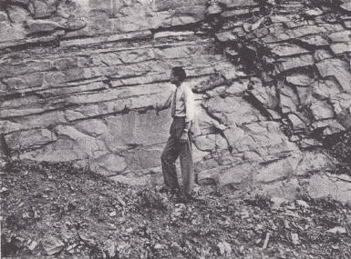
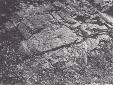
| Fig.2. Bethel sandstone
(right) faulted down against the Renault limestone, Walche's Cut on the Illinois Central Railroad near Claxton Station southeast of Princeton, Caldwell County. |
|
 |
|
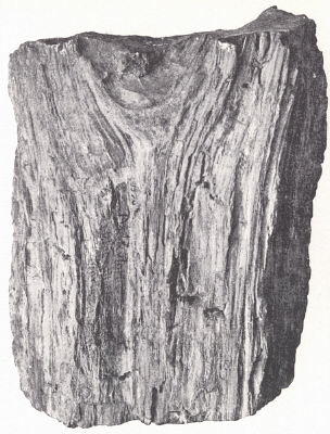
| Fig. 1. Petrified wood from the Ohio shale, Marion County. | Fig. 3. Farmers siltstone
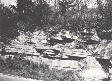
member of the New Providence formation. This member shows exceptionally even-bedding and is the commercial building stone known as the Rowan County freestone. Road cut west of Morehead (Stockdale, 1939). |
4. Hummel facies (developed in northern Rockcastle, Madison, and Jackson counties). Thickness, 35 to 50 feet or more. Two zones are recognized:
(b) Impure siliceous and argillaceous cherty limestones of the usual Muldraugh type up to about 20 feet thick. Other impure limestones.and shales intervene between these and the semilithographic, Lithostrotion-bearing St. Louis above. Their age is uncertain, and they are tentatively included in the Muldraugh. The normal Salem and the massive, cross-bedded Harrodsburg (restricted) limestone with many bryozoa are not developed in this region.
(a) Wildie siltstone member. (Wildie sandstone member of Butts (1922, p. 102) regarded by him as basal Warsaw. The underlying Floyds Knob he described as "fifteen inches of highly glauconitic shale with black nodules having the appearance of phosphatic nodules. Below the glauconitic layer is about 2 feet of impure fossiliferous limestone" (Fort Payne)). The member as developed near Wildie in Rockcastle County consists of 20 to 30 feet of bedded gritty siltstone with subordinate amounts of shale, but within a few miles in all directions shale rapidly increases at the expense of siltstone. This is the quarry rock known as the Rockcastle freestone. It is bounded above and below by glauconitic silt.
5. Olive Hill facies (developed from Estill County northward). Thickness, up to 50 feet. The section consists of:
(b) Twenty to 30 feet of argillaceous limestones with shale partings of uncertain age but tentatively referred to the Muldraugh. These beds are missing in the area to the north because of unconformity.
(a) Rothwell shale member. Thickness, 0 to 30 feet. It is the equivalent of the Wildie siltstone member. The rock is plastic clay shale varying from grey and green to maroon and purple, at places mottled, and with interbedded thin siltstones and occasionally thin fossiliferous limestone lenses. Some of the shale is glauconitic and there is a highly glauconitic silt in the middle of the formation. This shale member along with the Floyd's Knob formation and the Indian Fort shale member at the top of the Brodhead formation constitute Butts' (1922) Morris Mountain shale member of the Logan.
Unconformity at the base of the St. Louis, Ste. Genevieve, and Pottsville vary the extent of the section. No Warsaw is known though impure limestones (zone b above) in the southern area have not been definitely correlated. These are missing at Natural Bridge, Powell County, in Menifee County, and to the north. With the disappearance of the St. Louis northward the Ste. Genevieve rests on various levels down to and within the Brodhead. The Pottsville contact is similarly irregular and even more so, cutting deep into the Waverly.
MERAMEC
Warsaw (James Hall, 1857).—The upper and lower boundaries of the Warsaw limestone as described by Butts (1915, 1917, 1922) have been revised through the detailed work of Stockdale (1939). According to that author, errors in delimiting the Warsaw in western and southern Kentucky came from: (1) Failure to recognize a progressive change in the upper Borden from the clastic to a calcareous facies southward. The whole section as low as 120 feet below the Floyds Knob formation in eastern Larue County is limestone and these beds were included by Butts (1922) in his 240 feet of Warsaw in Hardin County. (2) Failure to recognize the Salem in Kentucky, the basal beds of which are represented in his "Somerset shale member of the Warsaw." (3) The recurrence of the Orthotetes keokuk fauna.
Stockdale assigned the lower 30 feet (lower Harrodsburg—impure siliceous and mixed limestone) of the 65 to 80 feet of Harrodsburg at Harrodsburg, Indiana, to the upper Borden. These beds together with the Edwardsville of Indiana constitute his Muldraugh formation. Three members in the Warsaw were named by Butts (1922):
(a) Wildie sandstone at the base. This has become the Wildie siltstone member of the basal Muldraugh.
(b) The Somerset shale member is correlated with the basal Salem.
(c) Garrett Mill sandstone member. This uppermost member was described as a flaggy sandstone, 5 to 10 feet thick, extending north from Overton County, Tennessee, to Pulaski County, Kentucky. It was described as being represented by a few inches of sandy limestone at Burnside and probably also by a fine quartz conglomerate in the vicinity of Mt. Vernon, Rockcastle County. Butts found it useful in marking the contact between Warsaw and St. Louis. This conglomerate, a silty to argillaceous limestone with streaks and patches of small quartz pebbles up to the size of a pea, is recognized by Stockdale (1939) in his section between Maretburg and Brodhead in Rockcastle County in the upper Salem or forming the top of it, though the determination of the latter here was not made with certainty.
The Warsaw is known to the west and south of the Blue Grass, but its presence has not been demonstrated in the area from Rockcastle and Jackson counties north. The normal type of massive cross-bedded Harrodsburg is not present, but impure limestones with shaly partings of uncertain age do occur in the southern part of this area between the impure siliceous argillaceous cherty limestone of the Muldraugh type and the semilithographic Lithostrotion-bearing limestone of the St. Louis.
As restricted (upper Harrodsburg) the Warsaw has a thickness of 15 to 25 feet throughout its area of known outcrop around the Blue Grass and constitutes a relatively small part of the limestone section hitherto assigned to it. The limestone is variable but is typically massive and cross-bedded in the lower part, in part crinoidal, sometimes cherty. Bryozoans are particularly abundant in the upper layers.
Butts (1922, p. 109) lists Metablastus wortheni, Talarocrinus simplex, Triccelocrinus woodmani, Athyris densa, Orthotetes keokuk (occurs in Keokuk), Marginirugus magnus, Spirifer keokuk (also in Keokuk but not abundant), Spirifer lateralis, and S. washingtonensis as introduced in the basal Warsaw almost without intermixture with Keokuk forms.
A very large part of the Warsaw fauna does not range up into the St. Louis. Included among these forms are Triplophyllum compressa, Palæacis cuneiformis, Metablastus wortheni, Pentremites conoideus, Talarocrinus simplex, several species of Glyptopora, Athyris densa, Brachythyris subcardiformis, Spirifer lateralis, S. washingtonensis, and Spiriferella neglecta (Butts, 1922, p. 110).7
| PLATE XIV | |
 |
 |
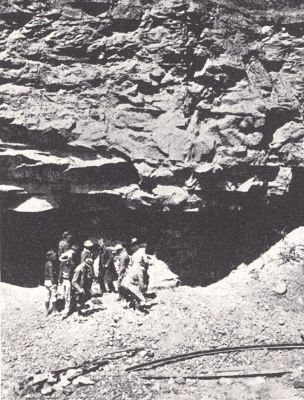
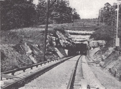
| FIG. 1. Glen Dean formation in
the severely faulted belt of Caldwell, Livingston, and Crittenden counties. Walche's Cut on the Illinois Central Railroad near Claxton Station, southeast of Princeton, Caldwell County. |
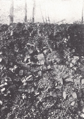
FIG. 2. Fort
Payne chert exposed in road cut on U. S. Highway 68 on east side of Tennessee River Valley between Cadiz and Murray. |
 |
 |
| FIG..3. Rock asphalt in the
Cypress sandstone near Summit, Grayson County. |
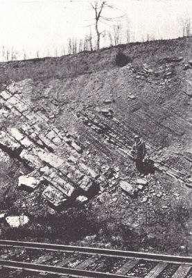
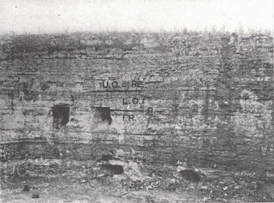
FIG. 4. Muldraugh,
Harrodsburg, and Salem limestones as marked. Quarry at West Point, Hardin County (from Stockdale, 1939). |
Spergen limestone (Ulrich, 1904, 1905).—The name was adopted by the United States Geological Survey in 1904 and is a synonym for the Salem = Bedford limestone of Indiana. It carries a distinctive diminutive fauna, one seldom found except in oolitic limestone and of little value for correlation where that type of rock is not developed. The most conspicuous fossil is the foram Endothyra baileyi.
The formation was recognized as far south as the Ohio River by Butts. At the same time he expressed the opinion (1922) that the formation in its normal development was absent in Kentucky and that it was a local lithologic facies of the upper Warsaw characterized by a peculiar diminutive fauna. This observation is essentially confirmed by Stockdale who finds that the ±20 feet of grey calcareous shale to argillaceous limestone at the base of the Salem in southern Indiana is Butts’ Somerset shale member of the upper Warsaw. The Salem was traced across Kentucky from Jefferson County as far as the Cumberland River in southern Pulaski County. The "Somerset shale member" has its type locality in that county and this lower zone has been recognized throughout the area examined, which, however, did not include the Cumberland River counties along the Tennessee border. The lithology, although locally similar or even identical with the typical formation in Indiana, shows a general change to more argillaceous limestone with fossiliferous shale zones southward. As indicated earlier a sandy upper zone constitutes Butts' Garrett Mill sandstone which forms the top of his Warsaw. The limestone is massive to shaly, fine to coarse grained, and some beds are oolitic. A thickness of as much as 90 feet is listed in Hardin County (other sections 30 to 55 feet), 65 feet in Larue, and 30 to 50 feet elsewhere with the lower shaly member usually about 15 feet thick but ranging up to 25 feet.
St. Louis limestone (Engelmann, 1847).—As originally defined the St. Louis included beds now recognized as Warsaw, Spergen, and Ste. Genevieve, and was more or less used in this sense by early Kentucky writers. The formation is a thick-bedded cherty limestone but some thin limestones and shales are present. "The succession from the Warsaw through argillaceous thick-bedded limestone with fucoids and Archeocidaris and commonly Melonites plates, to pure, bluish limestone with Lithostrotion is a constant feature of the basal St. Louis in Kentucky and Tennessee, and probably also in Indiana" (Butts, 1922, pp. 123, 124). Accompanying this lithologic change is the disappearance of the characteristic Warsaw fossils which terminate upward with the coarse crinoidal limestone at the top of the "Warsaw" (Salem) (above). The upper limit is recognized by the introduction of oolitic limestone and the abundant presence of Platycrinus penicillus (P. huntsvillae), which, however, is occasionally met with in the upper St. Louis.
The lithology is mainly that of a medium thick-bedded fine-grained commonly semilithographic medium to dark or black limestone. Butts recognized some coarse-grained rock in western Kentucky but stated (1922, p. 125) that "no such coarse, crinoidal, cross-bedded limestone as that which is so prominent a constituent of the Warsaw formation occurs in the St. Louis of Kentucky.” The St. Louis yields everywhere great quantities of compact yellowish chert, much of which is chalky in texture. Some compact layers of a lithographic texture have been commercialized in the vicinity of Brandenburg. In Hardin County earthy siliceous geode-bearing beds, rather suggestive of Warsaw, are developed more or less throughout the section. All along its outcrop in eastern Kentucky the top 10 feet or so is full of nodules of black flint associated with Lithostrotion. North of Rockcastle County the St. Louis is represented by an increasing thickness of compact yellow often spally limestone. From Irvine northward the lower argillaceous beds (Salem, p. 77) are missing and the yellow limestone overlies the New Providence and is in turn overlain by the black flint-bearing beds (total thickness at Irvine 25 feet, of which 8 feet are the upper beds).
The St. Louis is present throughout western Kentucky with a thickness of about 300 feet. At Green River Knob in Casey County it is 120 feet. Along the Pottsville Escarpment in eastern Kentucky it ranges from 100 feet at Somerset to 25 feet at Irvine, 25 feet at Natural Bridge, and 30 feet at Frenchburg. This locality was listed by Butts (1922) as the northernmost point observed, and 15 miles to the northeast he observed the Ste. Genevieve resting on the "New Providence" (Waverly). The St. Louis, though, has been observed in a 6- to 8-foot exposure near Red Hot and else-where in southern Greenup County. Near the Ohio River in that county a basal conglomerate in the Pottsville is composed of fossiliferous St. Louis chert slabs in a sandstone matrix. Chert drift is common all along the hilltops to the south. At Pineville the thickness is 115 feet.
The most useful guide fossils are the two species of Lithostrotion—L. basaltiforme8 (canadensis) and L. proliferum. Both are abundant. The former is restricted to the St. Louis and the latter is said to occur sparingly in the basal Ste. Genevieve. Among forms commonly present are fenestellids, Sulcoretepora lineata and pustulosa, Spirifer pellaensis, S. tenuicostatus, S. bifurcatus and a number of species of "Productus" (now Diaphragmus, Dictyoclostus, etc.).
Ste. Genevieve (Shumard, 1859).—In western Illinois and Missouri the Ste. Genevieve is bounded below by the St. Louis limestone and above by the Aux Vases sandstone, which is not present in outcrop in Kentucky. The formation is present throughout the area of outcrop in Kentucky except locally where it is cut out by the basal Pennsylvanian unconformity, as in parts of Greenup County where the Pottsville is in contact with the Waverly, and in southern Larue County and vicinity where the Pottsville rests on the St. Louis.
In Eastern Kentucky there is evidence of unconformity at the base. Butts (1922) called attention to: (1) the irregular contact apparently involving only slight erosion, (2) the conglomeritic character of the basal foot where it rests on the New Providence at Olive Hill and Carter, and (3) the presence of angular black chert fragments in the lower 10 feet of limestone where it rests on the St. Louis in the region between Burnside and Mt. Vernon. This is also present in Wolfe and Powell counties.
The situation in western Kentucky is more difficult and it is seldom possible to draw a precise boundary between the two. Such criteria as the appearance of oolitic limestone and Platycrinus penicillus (P. huntsvillae) in the section, and the disappearance of Lithostrotion basaltiforme and L. proliferum are commonly used. Butts (1922) suggested that the horizon of beds present in Hardin County, Illinois, below the oolitic beds and containing P. penicillus may not be represented in the section elsewhere.
A threefold division is recognized in the western counties: the Fredonia oolite, Rosiclare sandstone, and Ohara limestone. These divisions are recognizable eastward to Christian County at least, but the sandstone member is not recognized in Warren and Butler counties.
1. Fredonia oolite (Ulrich, 1905).—This lower division is mainly a thick-bedded, coarsely oolitic, predominantly light grey limestone interbedded with non-oolitic compact to crystalline, drab to light grey limestone. The latter constitutes perhaps half of the formation. Cross-bedding is often conspicuous. Fragmental fossils are common, particularly crinoidal remains. Some beds have abundant chert, and residual Ste. Genevieve soils, deep red like those of the St. Louis, are full of it. The oolitic beds are of high purity. This limestone is quarried in Meade County and used by the Kosmosdale Cement Company.
The Fredonia constitutes the main mass of the Ste. Genevieve and is known to extend from Ste. Genevieve, Missouri, south to Huntsville. Alabama, and north into southeastern Iowa.
2. Rosiclare sandstone (Ulrich, 1905).—The Rosiclare sandstone is known as far east as Christian County, where it has a thickness of 2 to 20 feet (Sutton, 1928). It is a calcareous sandstone with angular grains.
3. Ohara limestone (Ulrich, 1905). The Ohara has been a fruitful source of controversy. Ulrich has placed the whole of the Ste. Genevieve in the Chester because of the Chester nature of Ohara faunas, collected however from the upper part. Stuart Weller (1920, and later publications) has shown that the Ohara as recognized is a composite unit, the two divisions separated by an unconformity. Evidence for it is found in (a) the local development of limestone conglomerate, and (b) a notable change in fauna at this level. He correlated the Upper Ohara with the Renault (Chester).
Levias (Sutton and Weller, 1932).—Sutton and Weller (1932, p. 439) suggested the abandonment of the name Ohara, "made useless by thirty years of misinterpretation,” and proposed the term Levias for the upper member of the Ste. Genevieve, i.e., those beds intervening between the Rosiclare and the Aux Vases (or Renault = Upper Ohara = lower Gasper where the Aux Vases is absent). The Levias has essentially the same character as the Fredonia.
In eastern Kentucky Butts (1922) recognized a relatively thin zone of persistent thick-bedded limestone and oolite with locally abundant Pentremites princetonensis and Metablastus glaber. He has traced it from Overton County, Tennessee, to Carter, Kentucky. It is set off above and below by "thin but persistent layers of shale or shaly limestone at places accompanied by thin limestone conglomerate or by limestone cobbles of small size” (pp. 144,145). He regarded this limestone as the Upper Ohara of western Kentucky. His Gasper in these sections thus did not include the Upper Ohara (Renault), which is generally 5 to 10 feet thick but locally (Somerset vicinity) ranges up to 40 feet.
Between Berea and Mt. Vernon the Ste. Genevieve limestone becomes thin bedded. At Irvine the mass of the formation is composed of the thin-bedded oolite, which is underlain by 10 to 12 feet of thick-bedded bouldery oolite, the planes of separation pronounced and conspicuous. At Carter the usual thick-bedded character is again found. A conspicuous feature of this vicinity and northward to the Ohio River is the introduction of very small quartz pebbles and sand grains in abundance in a cross-laminated rock. At Limeville (Greenup County) and elsewhere the rock is so siliceous that it resembles in its weathered aspect a sandstone. At Pineville and Cumberland Gap the formation is the normal limestone.
The Ste. Genevieve varies considerably in thickness. In the western counties (Caldwell, Crittenden, Livingston, etc.) it has a thickness of 250 feet or more, of which 40 to 50 feet constitutes the Levias (lower Ohara), a maximum of 20 feet the Rosiclare, and the balance, approximately 200 feet, the Fredonia. Christian County has about the same section. Meade and Barren counties show 160 to 200 feet without the Rosiclare member. Along the eastern Pottsville Escarpment the section is thinner, around 50 to 60 feet to the south, and thinning northward to as little as 20 feet. At Pineville it is 80 to 100 feet thick.
The most distinctive guide fossil is Platycrinus penicillus (P. huntsvillae), whose toothed stem segments are easily recognized and abundant. It is rare, though, in the northern part of the eastern outcrop. While unknown above the Ste. Genevieve, it is known in the upper St. Louis. Similarly, the characteristic Lithostrotion proliferum of the St. Louis is said to occur in the lower beds of the Ste. Genevieve. Pugnoides ottumwa is characteristic and common in the southern and western area of outcrop. The corals Michelinia subramosa and Lithostrotion harmodites are also distinctive and not uncommon in the middle of the formation.
CHESTER
 |
| * After Malott (1919) in Indiana. Some of these may be traced for considerable distances into Kentucky and are recognized in drill records. |
The term was first used by Swallow (1858) as a formational name for a sandstone now known as the Palestine. His "Ferruginous sandstone" was another Chester sandstone, the Aux Vases. In the early literature the Chester formations appeared under a number of designations. Owen (1838) used the term Archimedes limestone in Indiana, but then through miscorrelation applied the same term to beds of Keokuk age in Iowa (Owen, 1852). Swallow (1855) also used the same term for Keokuk, Warsaw, and Spergen beds in Missouri. Hall (1857) differentiated the three Archimedes limestones, naming the upper one Kaskaskia, which thereby became a synonym of Chester. The first systematic subdivision of the Chester was that of Ulrich, whose classification of the formations of the Chester has been considerably modified and extended.
In a recent paper Dana and Scobey (1941) have questioned the validity, of the recognized Chester section below the Hardinsburg sandstone in Indiana and adjoining parts of Kentucky as correlated with the standard section of southwestern Illinois. Their findings based on a study of sample logs across the coal basin are indicated in the accompanying chart which is reproduced from their paper.
| CORRELATION OF SUBSURFACE NOMENCLATURE OF
THE CHESTER (After Dana and Scobey) |
 |
| *After Malott (1919) in Indiana. Some of
these may be traced for considerable distances into Kentucky and are recognized in drill records. |
The basal Paint Creek was found to be a distinctive zone and as indicated emerges from beneath the Coal Measures as the top of the Ste. Genevieve of Indiana and Hancock, etc., counties, Kentucky. Similarly, the Cypress sandstone is represented by what in this state would be the Elwren sandstone (middle Paint Creek).
That such miscorrelations, especially that of the Ste. Genevieve-Chester contact, have been made seem to the writer unlikely. Should the Cypress of Kentucky prove to be not the Cypress of the type locality in Union County, Illinois, a revival of the old term Big Clifty would seem to be warranted.
LOWER CHESTER
Aux Vases sandstone (Keyes, 1892).—This is the "Ferruginous sand-stone” of earlier geologists. For some years it was confused with the Cypress and the name was for a while abandoned. The name Brewerville sandstone (Stuart Weller, 1913) has been used. It is typically developed in the Mississippi River bluffs of Randolph County, Illinois, and Ste. Genevieve County, Missouri, and is not known to extend in outcrop into Kentucky.
Renault limestone (Stuart Weller, 1913).—In Kentucky the Renault is mainly thick-bedded limestone, but in the Mississippi Valley region sand-stone and shale units occur. Here it rests disconformably on the Aux Vases, Ste. Genevieve, and St. Louis formations, with locally a basal conglomerate. In Ste. Genevieve County, Missouri, the pebbles are mostly chert, occasionally igneous (Weller, 1920). The limestone varies from crystalline to earthy to oolitic. In western Kentucky the Renault rests on the Levias (Lower Ohara). Weller recognized an important unconformity at this contact based on change in fauna. It is also locally marked by a limestone conglomerate.
Fossils are not particularly abundant and are essentially the same as in the Paint Creek where they occur in greater numbers. This horizon is characterized by the appearance of a wealth of species and individuals of the crinoid genus Talarocrinus. This Talarocrinus fauna marks the introduction of the Chester.
In southwestern Illinois and vicinity the Renault is well marked off by the Aux Vases sandstone below and the Bethel sandstone above. With the disappearance of the Aux Vases eastward, the limestone succession intervening between the Rosiclare and the Bethel was called the Ohara by Ulrich (1905). In his many papers Stuart Weller has called attention to the two-fold nature of the Ohara, a Lower Ohara with the characteristic Ste. Genevieve fauna and an upper Ohara (Renault) with the Chester Talarocrinus fauna. With the disappearance of the Bethel to the east, a similar difficulty arises in separating the Renault from the Paint Creek.
| PLATE XV | |
 |
 |
| FIG. 1. Big Injun sand (upper
Waverly), Pound Gap section, Letcher County. The outcrop is in the Pine Mountain thrust block. Under cover the Big Injun is a producer of oil and gas. |
FIG. 2. Maxon
sand (Pennington), Pound Gap section on Pine Mountain, Letcher County. |
 |
 |
| FIG. 3. Glen Dean
formation exposed in tunnel and cut of the Southern Railroad at Sloan's Valley, Pulaski County. This is a famous fossil locality from which many of Ulrich's types from the Glen Dean came. Much of the material was collected in the dump just south of the tunnel. |
FIG. 4. Ste. Genevieve-Renault
section, Cedar Hill Quarry, 3 miles southeast of Princeton, Caldwell County. (See figure and section by Butts, 1915, pl. 13, p. 54.) Bethel ss................................................................................................ . 10 ft. Upper Ohara (Renault) ls. with limestone conglomerate at base... .72 ft. STE. GENEVIEVE Lower Ohara Is........................................................................................ 25 ft. Rosiclare ss................................................................................................ 2 ft. Fredonia |
In Indiana Malott (1919, 1920) subdivided the Renault and Paint Creek limestones each into three divisions on the basis of sandstone members in the middle of the formation. Stouder (1938) has traced these divisions into Kentucky along the eastern margin of the Western Coal Field. In this work he called attention to the southward disappearance in ascending order of the clastic members of the Lower Chester.
There are three divisions of the Renault:
1. Paoli limestone.—This is described as a dark grey to white compact to crystalline and oolitic fossiliferous limestone. Stouder (1938) recognized a limestone in Hardin County in this position. He referred to it as unnamed, and it is not certain that it involves the same beds to which the name Paoli was given. It is not always present in the section. Platycrinus penicillus (P. huntsvillae) occurs below. Campophyllum gasperense was not seen in it, but it is present in the limestone above up to the Sample sandstone (Stouder, 1938). Thickness, 0 to 23 feet.
2. Mooretown sandstone.—This gnarly sandstone member, including also calcareous shale and a thin but rather persistent streak of coal, is known throughout Meade, Breckinridge, and most of Hardin County, and may be recognized as far south as Hart County. It rests on either the "Paoli" or Ste. Genevieve with irregular contact as indicated by local excessive thickness up to 75 feet. The normal thickness seems to be about 8 to 25 feet. It weathers to gnarled lumps of sandstone with many Lepidodendron casts and root fragments. It is recognized in the Owensboro oil field (Wesley, 1936) as the Cunningham break.
3. Beaver Bend limestone.—This upper member of the Renault was de-scribed in Indiana by Malott as oolitic and often massive, but was described by Stouder (1938) in Kentucky as a siliceous, ferruginous, coarsely crystalline limestone. It is about 15 feet thick in Breckinridge County, and thickens and becomes purer toward the south. Pentremites godoni makes its appearance in the section at this level and P. pyriformis is common. Other Lower Chester fossils include Spirifer leidyi and Chonetes chesterensis. It is the zone of Campophyllum gasperense.
Shetlerville formation (Stuart Weller, 1920).-This is a basal shale facies of the Renault, locally, developed in Hardin County, Illinois, and Crittenden County, Kentucky. The fauna is somewhat different from that normally present in the Renault and Stuart Weller (1920) regarded Amplexus geniculatus, Spiriferina subspinosa, Talarocrinus buttsi and Globocrinus unionensis as diagnostic. It has a thickness of about 15 feet.
Bethel sandstone (Butts, 1917).-The Bethel is a more or less massive medium- to fine-grained sandstone, similar in character to most of the other Chester sandstones. The color is yellow to brown and there is much cross lamination. Small quartz pebbles are locally present in the lower part. A few fossil land plants have been found.
A thickness of 60 to 75 feet is found in northern Livingston County with a local maximum of 100 feet. In Caldwell County it is 25 to 40 feet thick and thins eastward to 10 feet at the Christian-Todd county line and is unknown in the section farther east. Northward along the eastern flank of the Western Coal Field it reappears in Hart County and is well developed in Breckinridge and Meade counties where it has gone under the name of Sample sandstone of Butts (1917). The correlation of these two sandstones has been a controversial point for years (see papers by Butts and Stuart Weller, and more recently Butts, 1929, and Sutton and J. M. Weller, 1932), but their equivalence now seems well established. In southwest Illinois this formation is represented by the Yankeetown chert (Stuart Weller, 1913).
  |
|
FIG. 6. Stratigraphic relationships of the Chester formations (western half after Stuart Weller, 1920) |
Paint Creek (Stuart Weller, 1913).-In the westernmost exposures in Crittenden and Livingston counties the formation is made up of black to grey fissile shale with a little impure limestone in the lower part. Above the shales come thin-bedded calcareous sandstones weathering to yellow or brown porous sandstone. Over most of its area of outcrop the formation consists of limestone with interbedded shale, and is frequently highly fossiliferous. The limestone varies from crystalline to oolitic to sandy. The thickness varies in Livingston, Caldwell, and Crittenden counties from 40 to 175 feet. It is recognized as a distinct formational unit eastward until the pinching of the Bethel sandstone renders its differentiation from the Renault impossible.
In Indiana Malott (1919) has recognized three divisions.-The Elwren sandstone constitutes the middle member. It is a sandstone about 40 feet thick in Breckinridge County, thins southward and is represented by 3 feet of shale at Girken in Warren County. Below it is the Reelsville limestone, an oolitic limestone much like the Ste. Genevieve. Common fossils include Pentremites godoni, Productus elegans, Pentremites pyriformis, Girtyella brevilobata, Chonetes chesterensis, and Spirifer pellaensis. It is a persistent formation 25 to 30 feet thick in Breckinridge County and somewhat thicker to the south. Stouder (1938) mentions a greyish blue argillaceous limestone at the top and a persistent 2 feet of mudstone 12 feet below the top, both useful for structural work. The upper member, the Beech Creek limestone, was referred to as the "Productus" inflatus zone by Butts (1917). It ranges from 4 to 12 feet thick and is known from the Ohio River south to Warren County. The limestone is coarsely crystalline. In recent work Malott (personal communication) has identified this member in the vicinity of Sloan's Valley, Pulaski County, in eastern Kentucky, where it is characterized by an abundance of very large crinoid stems. This zone of large crinoids was recognized by Butts (1922) in his upper Gasper, and can be traced northward at least to the vicinity of Natural Bridge.
Renault-Paint Creek-Gasper-Girken.-As noted above the Bethel sandstone pinches to the east and is last known in the vicinity of the Christian-Todd county line. Farther east there is little basis for separating the Renault and Paint Creek. Butts (1917) proposed the name Gasper to replace the name Tribune, an earlier and misused term. J. M. Weller (1927) used the term Renault-Paint Creek for these beds in Edmonson County. Sutton and J. M. Weller (1932) proposed the name Girken for the undifferentiated Renault-Paint Creek instead of Gasper. The writer is inclined to like the simplicity of the term Renault-Paint Creek which defines itself. At the same time the term Gasper is rather widely used in the state for this part of the section.
The faunal change at the base of the Chester is the most marked one within the Mississippian (Stuart Weller, various papers). This marks the disappearance of Platycrinus penicillus (P. huntsvillae), Pugnoides ottumwa, and other distinctive Ste. Genevieve forms and the introduction of many species and individuals of Talarocrinus, which has given rise to the term Talarocrinus fauna. Species of this genus are easily recognized in fragmental remains by the bilobed bases and rectangular radial plates. Pentremites pyriformis and relatives are introduced and the genus Lyropora is locally abundant. Aggassizocrinus makes its first appearance. With only one known specimen at a lower horizon, Septopora begins its range at this level. Archimedes compactus and A. communis are abundant and more typically developed here than in the higher horizons where related forms with wider spaced volutions (A. intermedius, A. swallovanus, etc.), are more common.9 In the western counties Sulcoretepora10 labiosa is very common and characteristic and Glyptopora punctipora is also characteristic.
Faunally the Renault and Paint Creek are rather closely related, the main points of difference being:
1. The rather limited number of Archimedes and Pentremites in the Renault, and at the same time a greater abundance of Talarocrinus.
2. Pterotocrinus makes its appearance in the Paint Creek.
Campophyllum gasperense has been found as a persistent and widespread zone 20 to 40 feet above the base of the Gasper (Butts). Recent finds (Button and J. M. Weller, 1932) show that this coral occurs both above and below the Bethel, hence apparently in both the Renault and Paint Creek.
MIDDLE CHESTER
Cypress sandstone (Engelmann, 1863).—In its typical development the Cypress is a massive grey cliff-forming sandstone, commonly cross-bedded and frequently showing current ripple marks. Locally it is thin-bedded and shaly as in the Princeton quadrangle. Locally also the sand is almost pure white.
It is the most uniform in extent of any of the Chester sandstones in Kentucky and forms the cap rock of the Dripping Springs Escarpment. It is not known on the eastern side of the Arch in Kentucky unless represented by 10 feet of sandstone which occurs at about this horizon 12 miles southeast of Monticello (Munn, 1914; J. M. Weller, 1931). Southward in Tennessee it outcrops along the front of the Cumberland Escarpment (continuation of Pottsville Escarpment in Tennessee).
The thickness varies from a maximum of 125 feet in northern Livingston County to 30 or 40 feet in Caldwell County, 80 feet in Butler and Warren counties, and 60 feet in northern Breckinridge County.
Fragmentary remains of plants with an occasional Lepidodendron trunk are found. Coal streaks are locally developed. A list of fossil plants from the upper part was given by Noe (J. M. Weller, 1927). Marine invertebrates are occasionally found.
The Cypress sandstone is the Big Clifty sandstone of Norwood. Butts (1922) correlated it with the "Newman" sandstone lentil of the Newman limestone in the Standingstone and Wartbury quadrangles of eastern Tennessee and with the Hartselle sandstone of Alabama and Sequatchie Valley of Tennessee.
Golconda formation (Brokaw, 1917, and Butts, 1917).—The Golconda is the equivalent of the lower part of Stuart Weller's Okaw (1913)11 of western Illinois. The formation varies greatly from the lithology shown at the type locality, ranging from as much as 90 per cent shale to as much as half limestone. The limestone is oolitic, crystalline, or formed of broken fossils. A rather characteristic feature from Hart County northward is the abundance of rectangular white chert blocks in the weathered outcrop. The shales are equally varied, ranging from grey to green to black and locally red.
Butts (1922) regarded the Golconda as being represented east of the Cincinnati arch in Kentucky by a bed of marly green shale, containing streaks of red shale and in places some limestone. This shale parting has been regarded as the "Pencil Cave"12 of eastern Kentucky logs.
The recognition of the Beech Creek limestone (upper Paint Creek) in the upper "Gasper" at Sloan's Valley and elsewhere (see p. 87) indicates a Golconda age for the limestones intervening between this zone of large crinoid stems, and the "Pencil Cave" and Glen Dean above. Chert is present and is rather distinctive.
The most distinctive fossil is Pterotocrinus capitalis although this crinoid, recognized usually by the wing plates of the calyx, is at least not so well developed in the Warren-Butler-Edmonson County region as farther west. Camarophoria explanata is introduced at this level, Rhynchopora perryensis is restricted to it, and these two forms are associated with the more widely ranging Composita trinuclea and Cliothyridina sublamellosa. Agassizocrinus is common. Other forms restricted to the formation, as far as known, are Pentremites obesus, P. platybasis, and Archimedes lativolvis. In the Warren-Edmonson-Butler County vicinity the usually characteristic Glen Dean forms Archimedes laxus and Prismopora serrulata are found in the Golconda. (See also footnote p. 88)
Hardinsburg sandstone (Butts, 1917).—The Hardinsburg sandstone is known throughout the area of outcrop of Chester in western Kentucky but is seldom the conspicuous cliff-former that the Cypress is. It is not present in the section on the eastern side of the Arch. Fresh exposures more or less resemble those of the Cypress. It is medium- to fine-grained massive to thin-bedded flaggy yellow sandstone. In Butler County it is dominantly shale with only 5 to 10 feet of sandstone. In Crittenden County the thickness ranges up to 140 feet. The formation thins to 20 to 60 feet in Caldwell County and 30 to 40 feet in Edmonson County. This thickness is maintained north to the Ohio River.
Glen Dean limestone (Butts, 1917).—The lithology is much like that of the Golconda consisting of interbedded fine to coarsely crystalline lime-stone and shale but varying widely in character and proportions of lime-stone and shale. The limestones are commonly fossiliferous, blue to grey, often thick-bedded. The shale varies from black to grey or green. It is known throughout both western and eastern areas of Chester outcrop.
The thickness varies from 60 to 80 feet in Crittenden and Livingston counties. Locally in Breckinridge County Butts (1917) found a thickness of 180 feet. In eastern Kentucky it is 35 feet near Mt. Vernon but thickens southward to 140 feet in Overt on County, Tennessee.
The Glen Dean is locally highly fossiliferous. A vast number of fossils have been collected and described from an upper shaly zone at Sloan's Valley, Pulaski County. The assemblage of fossils is very characteristic and includes Prismopora serrulata, Archimedes laxus, Archimedes sublaxus, Cheilotrypa hispida, Tabulipora ramosa, Tabulipora meekana, Pentremites spicatus, Pterotocrinus acutus and P. bifurcatus. Of these, Archimedes laxus, Prismopora serrulata, and Cheilotrypa hispida are particularly useful, though the first two mentioned occur in the Golconda in the Edmonson-Warren-Butler County region. Prismopora serrulata has also been observed in the Vienna and more rarely in the Menard (J. M. Weller, 1931). Cheilotrypa hispida in the writer's experience has been the most consistent and at the same time is abundant. The Glen Dean constitutes the upper part of the Bangor limestone of Alabama and of the Newman limestone of the region of Cumberland Gap and Big Stone Gap, Virginia.
UPPER CHESTER
Tar Springs sandstone (Owen, 1856).—The name is taken from Tar Springs, 3 miles south of Cloverport, Breckinridge County. Here a bituminous spring emerges from this sandstone. The name was revived by Butts (1917). The formation varies greatly in character, even within short distances, from cliff-forming like the Cypress to thin-bedded and shaly. A rather consistent feature in the western counties is a shale bed near the middle of the formation, which is frequently carbonaceous and often includes a seam of impure coal. The Tar Springs pinches to the east and is last known in Warren County. In Butler and Edmonson counties it is sporadically developed and in the latter County was included by J. M. Weller (1927) in his Leitchfield formation.
A maximum thickness of about 200 feet is found in Caldwell County and vicinity and about 100 feet in Livingston and Crittenden counties. Eastward it thins to a maximum of 45 feet in Butler County, 35 feet in Warren County, and about 55 feet in Breckinridge County. It does not occur as a formational unit on the east side of the Arch, where it is a part of the Pennington formation.
Plant remains are rather common. Butts (1917) listed the fern Cardiopteris and the well-known Stigmaria, Sigillaria, and Lepidodendron. Stuart Weller (1920) found considerable well-preserved plant material in a shale bed in Hardin County, Illinois.
Vienna limestone (Stuart Weller, 1920).—This is a thin Chester unit but remarkably uniform in character in the western counties as far east as Christian County. In the west the lower part of the formation is characterized by the presence of a great deal of chert in thin layers. To the east, with the disappearance of the Waltersburg sandstone and the cherty character of the limestone, it is difficult to separate from the Menard. It is included in J. M. Weller's (1927) Leitchfield formation of Edmonson County and vicinity and Butts' (1917) Buffalo Wallow formation. Russell (1934) identified a limestone horizon 35 to 50 feet above the Glen Dean in Hart County as the Vienna. Here it is not cherty and apparently corresponds to a limestone member of the Leitchfield which J. M. Weller (1927) described as massive, 4 to 20 feet thick, and about 45 feet above the Glen Dean. Stouder (1938) recognized it again to the north in Breckinridge County, where it is cherty and has a thickness of 15 feet.
There is nothing particularly distinctive paleontologically. As noted earlier, the characteristic Glen Dean Prismopora serrulata has been found and Sulcatopinna missouriensis, which is rather characteristic of the Menard makes its first appearance.
Waltersburg sandstone (Stuart Weller, 1920).—This sandstone formation is best represented in the westernmost counties. A massive phase is developed in Illinois where it attains a thickness of 60 to 70 feet. Eastward in Kentucky it thins to 7 to 20 feet in Caldwell County and at the same time becomes thin-bedded but usually even-bedded. The sandstone is associated with dark to yellow shale which may comprise half of the section. A characteristic feature in this thin-bedded shaly phase is the development of a high degree of jointing, breaking the sandstone layers into sliver-like blocks a few inches across and a foot or more in length. This is locally a useful feature for field identification. From Warren to Breckinridge County it has been included in the undifferentiated Upper Chester as a part of the Buffalo Wallow = Leitchfield formation. Stouder (1938) has more recently differentiated some of these beds and found the Waltersburg represented in the northern of these counties by a 75-foot shale-sandstone succession with a well-marked 12-foot sandstone zone at the top.
Menard limestone (Stuart Weller, 1913).—The Menard is present throughout the western counties in Kentucky but disappears eastward to form a part of the Leitchfield (Buffalo Wallow) formation. Stouder (1938) recognized it as consistently present along the western margin of the Western Coal Field north of Warren County. It is not known as a formational unit to the east of the Cincinnati arch.
The formation is compact to dense, grey to dark blue, sometimes massive limestone with uneven bedding, associated with shale of similar color. A zone of mudstone near the middle is a consistent feature in the eastern area. The shale is usually subordinate except in a 20- to 30-foot highly fossiliferous lower zone which is developed in the western counties. Locally (Caldwell County and vicinity) a little sandstone occurs in the upper part. A little chert is often present. The thickness ranges from 80 to 140 feet in the western area and is about 20 feet from Breckinridge to Edmonson County.
This horizon is marked by the introduction of a number of upper Chester forms. Composita subquadrata, Eumetria costata, and the typical Spirifer increbescens replace the lower ranging, C. trinuclea, E. vera, and the smaller and less typical S. increbescens. Sulcatopinna missouriensis is locally abundant and is regarded as characteristic. Pentremites fohsi and Pterotocrinus menardensis are not known from other horizons (J. M. Weller, 1931). Agassizocrinus conicus, Pentremites pyramidatus, and Linoproductus ovatus are common.
Palestine sandstone (Stuart Weller, 1913).—The Palestine is well developed in the western counties and as far east as Christian County. The lithology is much the same as other Chester sandstones. It is fine to medium grained, locally massive, usually flaggy to thin-bedded, and contains much sandy shale. In the western counties it has a thickness of 40 to 75 feet and ranges up to 100 feet in Christian County. Farther east it is represented but not identified within the Leitchfield formation. Stouder recognized it to the north in Breckinridge County where the sandstone (quartzitic) does not exceed 6 feet and occupies an interval of not more than 15 feet between the Menard and Clore.
Clore limestone (Stuart Weller, 1914).—The formation is composed of interbedded limestone and shale. The former is commonly compact and hard, in beds seldom exceeding 1 or 2 feet in thickness, and often shaly and highly fossiliferous. It has much the character of the Menard. The Clore is typically developed in the western counties and has been differentiated as far east as Christian County. The thickness varies from 30 to 60 feet. Eastward it is a part of the Leitchfield (Buffalo Wallow) formation. Stouder has differentiated it as a 20-foot shale-limestone unit within the Buffalo Wallow in Breckinridge County.
The most characteristic feature of the fauna is the presence of an abundance of Batostomella nitidula and other minute dendroid bryozoans. Composita subquadrata and Spirifer increbescens are abundantly present as in other Upper Chester faunas.
Degonia sandstone (Stuart Weller, 1920).—The Degonia sandstone is confined to the western counties, extending east as far as Christian County. In western Illinois it is a massive cliff-forming sandstone, but in Kentucky it is usually thin-bedded and is only locally massive. It is fine to medium grained but coarser grained in western Illinois, where it has been mistakenly identified as Pottsville. It has a thickness of up to 50 feet in Livingston County, 20 to 30 feet in Caldwell, and 10 to 20 feet in. Christian County. Stouder (1938) correlated it with a 52-foot shale interval in the Buffalo Wallow of Breckinridge County.
Kinkaid limestone (Stuart Weller, 1920). The Kinkaid is known as far east as Caldwell County and again in Breckinridge County and vicinity. In Livingston and Crittenden counties it has a known thickness of up to 200 feet but is normally much less. Considerable variation in thickness comes from disconformity with the Pottsville. Lithologically it is much like the Menard, consisting of hard dense grey limestone in beds up to 2 feet or more thick. These are interbedded with considerable quantities of shale varying from olive green to blue to carbonaceous. Locally sandstone is developed in the lower part in Livingston and Caldwell counties, and in this same region and westward into Illinois a massive white to black chert up to 5 feet thick and weathering into cubical blocks is rather characteristic of the lower part. In Breckinridge County an interval of not more than 20 feet of limestone and shale was correlated (Stouder, 1938) with the Kinkaid.
The known fauna does not include a great number of species, and nothing particularly distinctive has been recognized in the western counties. In Breckinridge County and vicinity Stouder found an abundant colonial coral regarded as Chaetetes to be a useful index.
Leitchfield (Norwood, 1876).—The name was more or less overlooked, though used by Moore (1878), Shaler (1887), and Glenn (1921), until revived by J. M. Weller (1927).
The term, as used (from exposures near Leitchfield, Grayson County), includes at its base the Tar Springs sandstone while the Buffalo Wallow, as defined by Butts (1917), included only the post-Tar Springs beds. Both constitute the undifferentiated Upper Chester. These shales attracted attention of early workers because of their high potash content and were recognized along the border of both the Western and Eastern (here known as Pennington shale) coal fields.
The formation consists principally of shale with occasional zones of interbedded limestone and sandstone. The shale is generally grey to blue but includes conspicuous amounts of red and green color. Some of the shales weather into plastic clays. Stouder (1938) has restudied the Buffalo Wallow section at its type locality 2 miles east of Cloverport, Breckinridge County, and has recognized the usual Upper Chester succession within it.
Pennsylvanian sandstone on top of hill
Shale, blue green...................................... 6 ft.
Limestone............................................. 3 (Kinkaid)
Shale, variably colored................................ 52 (Degonia)
Shale and limestone mixed............................. 20 (Clore)
Sandstone, thin and quartzitic......................... 2 (Palestine)
Shale, greenish........................................ 6
Limestone, shale and marl............................. 17 (Menard)
J. M. Weller (1927) recognized several persistent limestone zones within his Leitchfield but did not attempt a correlation. In Butler County a massive cliff-forming sandstone within 50 feet or less of the top is a conspicuous member.
The thickness of the formation has a known maximum of about 240 feet in Butler County. Considerable variation in thickness occurs because of the unconformity with the Pennsylvanian.
The fauna is much the same as in other Upper Chester formations.
Pennington formation (Campbell, 1893).—The Pennington as used in eastern Kentucky is essentially the Leitchfield and Buffalo Wallow of western Kentucky. It includes the undifferentiated post-Glen Dean Chester. As originally defined, it was used for the undifferentiated shales, etc., intervening between the Newman limestone (upper part = Glen Dean) and the Pottsville. The formation outcrops along Pine Mountain from the Breaks of the Sandy to the Tennessee line; similarly, along Cumberland Mountain. Along the Pottsville Escarpment it is present as far north as the vicinity of Berea, where the Pottsville overlaps onto older Mississippian formations.
The formation is mainly shale with minor amounts of sandstone and limestone. The shale is grey to green but with conspicuous zones of red. Butts (1922) regarded these as the southern extension of the red Mauch Chunk to a part of which the Pennington is equivalent.
With further work on the formation it may be possible to recognize a number of members. A cliff-forming sandstone member is well shown at Pound Gap and elsewhere, constituting the widespread Maxon "sand" of eastern gas fields. In his report on the Wayne County oil field Munn (1914) recognized a Spann limestone member in the lower part of the formation. This is a massive dark cherty geode-bearing limestone.
The thickness of the Pennington is 200 feet at Cumberland Gap, 135 feet at Burnside, and 35 feet near Berea and Mt. Vernon. At Big Stone Gap, Virginia, it has a thickness of 1100 feet.
 |
 |
 |
| Plate XVI.—Lower and Middle Mississippian section in western Kentucky |
Plate XVII.—Chester sections in western Kentucky |
Plate XVIII.—Mississippian sections in eastern Kentucky |
Footnotes
1 The Maury green shale is a thin unit named from Maury County, Tennessee, where
it intervenes between the Chattanooga and Fort Payne. In Kentucky it is a ±
2-foot zone of green to grey clay-shale, carrying phosphate nodules at the base
and not differentiated from the overlying New Providence. It grades into the
Black shale below. At Junction City, Boyle County, the nodules contain
crustacean and other remains (Foerste, 1906; Scott and Jeffrey, 1914). This zone
is widespread in Kentucky dying out to the northeast as the Bedford-Sunbury
wedge appears in Estill County. Along with the Black shale it was regarded by
Klepser (1936 and 1937) as a time-transgressing unit.
2 The Rockford limestone (Goniatite limestone) is a ± 2-foot bed of dense
brittle and persistent limestone below the New Providence in southern Indiana
which locally, as at Rockford, Jackson County, carries many fossil goniatites.
It was assigned a Kinderfoook age by Meek and Worthen (1861) and this was
corroborated by Kindle (1899). This bed has been traced south to New Albany but
has not been identified in Kentucky.
3 The term "Linietta clay" was used for the soft green New Providence shales
from Linietta Springs, near Junction City, Boyle County, by Foerste (1905b),
before their correlation with the New Providence was established.
4 At the horizon of the similar Rarden shale member of Hyde in southern Ohio but
not so well developed this far south.
5 Beds formerly assigned to the Warsaw.
6 The Riverside sandstone, a facies of the Edwardsville in Indiana has been
erroneously identified as Holtsclaw, and the name was used by Twenhofel (1931)
in preference to the other.
7 Somerset shale = Salem included in the Warsaw and recognized as an important
source of Warsaw fossils.
8 A single specimen of Lithostrotion basaltiforme has been reported found in the
lower few feet of the oolitic Ste. Genevieve associated with Pugnoides ottumwa
in Tennessee (Kendall Born, personal communication).
9 In contrast to this statement which was based on a study by the author of
collections from Illinois and neighboring counties in Kentucky, Stouder (1938)
found that in Meade, Hardin, and Breckinridge counties Archimedes compactus is a
characteristic and abundant fossil of the Golconda.
10 Cystodictya Ulrich
11 Sutton (1934) has shown that the Okaw represents not only the Golconda-Glen
Dean interval but includes also the Tar Springs, Vienna, and Waltersburg
horizons.
12 The "Pencil Cave" marks off the "Little Lime" (Glen Dean) above from the Big
Lime (variable but ranging from Warsaw or St. Louis through the Ste. Genevieve
and Renault-Paint Creek) below. It is mostly 3 to 5 feet thick but is known to
reach 40 feet. In most places it has been regarded as a good horizon marker, but
in West Virginia and probably also in adjoining counties of Kentucky as many as
five Pencil Caves are known in a 50-foot zone of thin limestones (Lafferty,
1941). The third is regarded as the usual "Pencil Cave." It is doubtful that the
"Pencil Cave" of the Eastern Coal Field, as recorded in logs, always occupies
the same stratigraphic level.