|
|
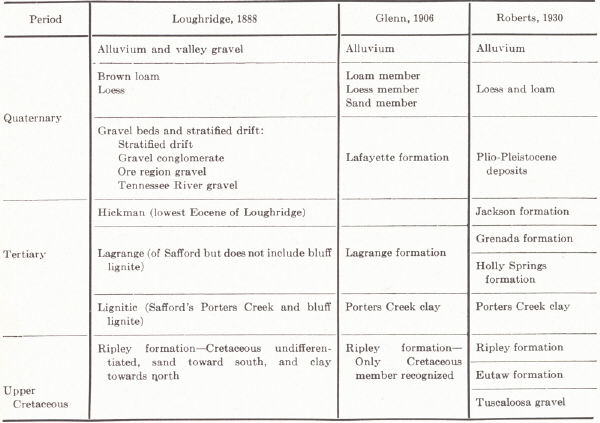
| Plate XXIX.—FIG. 1. Geologic column in the Jackson Purchase region (Roberts, 1931a) |
The Cretaceous outcrop is restricted to a narrow belt along the western margin of the Purchase and adjoining edge of the Pennyroyal. Here it rests on the Fort Payne chert and St. Louis limestone with mild angular unconformity, because of the eastward dip of these beds beneath the Pennsylvanian of the Western Coal Field. To the west it is covered by the Tertiary. Exposures are few as a result of cover by the Lafayette gravels and more recent alluvium.
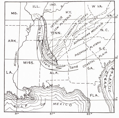 |
| FIG. 9. Probable physiographic provinces and
drainage in Tuscaloosa time, extending from Georgia into Kentucky (Roberts, 1929b—modified after Berry, U.S. Geol. Surv., Prof. Paper 112, 1919, p. 27). |
Tuscaloosa (Smith and Johnson, 1887).—The name was applied to the basal Cretaceous in the vicinity of Tuscaloosa, Alabama. It was traced northward through western Tennessee by Wade (1914) and first recognized in Kentucky by Roberts (1927). These beds are well known in "Between the Rivers" but Roberts reported only one outcrop west of the Tennessee River.
The Tuscaloosa consists of poorly assorted unindurated beds of gravel. They are of light color and mainly chert, but some limestone is present. Fossils indicate their derivation mainly from the underlying Mississippian (Ft. Payne—St. Louis). The pebbles are well rounded, average 1 to 2 inches in diameter, but range as high as 15 inches. The matrix is of finely divided calcareous and siliceous material, much of which is clay and constitutes up to 15 per cent of the mass. Iron oxide is limited to a few layers and there is little organic material. Local lenses of clay occur and occasionally pockets of limonite.
In their high degree of rounding as well as in color these rocks contrast with the Lafayette. The pebbles of the latter are contained in a sand matrix of reddish brown to yellow color and are coated with iron oxides. Fossils other than reworked Mississippian specimens have not been found. The Tuscaloosa was regarded by Roberts (1929b) as marine but Twenhofel (1931) interpreted it as probably fluviatile.
The formation is 170 feet thick in the exposure on the Davis Highway in Trigg County and constitutes the entire Cretaceous section east of the Cumberland River. Northward it becomes discontinuous in Livingston County. Near Smithland, Roberts recorded 10 feet of gravel. This is the nearest occurrence to the Ohio River.
Eutaw (Tuomey, 1850).2—In the absence of fossils the Eutaw is difficult to separate from the Ripley above. The main lithologic contrast is the lack of clay. Exposures are known in Galloway and Marshall counties, none of them more than 5 to 10 feet thick. It appears to wedge out in Marshall and is unknown in McCracken County. Between the Tennessee and Cumberland Rivers it is known only in Trigg County. The Eutaw overlies the Tuscaloosa unconformably in Tennessee and Roberts and Meacham (unpublished manuscript) recognized this relationship in Trigg County. The contact has not been observed in the Purchase proper.
The Eutaw is composed of reddish brown, coarse to medium sand. In Tennessee colored clay and lignitized wood occur but these are unknown in Kentucky. The sand is composed of quartz with small amounts of feldspar, mica, etc., and is colored by hydrated iron oxide. There is a variable amount of clay in the sand, at times small pebbles of quartz and chert. Thin layers of sand are locally indurated by iron oxide. Cross-bedding is common.
Along the Davis Highway west of Golden Pond these sands are about 40 feet thick. Glenn (1906) has recognized the formation in deep wells at Paducah, La Center, and Hickman, and it probably underlies most of the Purchase.
A. Section along the Jefferson Davis Highway between Golden Pond and the Tennessee River, Trigg County (J. K. Roberts, 1929, pp. 304-305).
Tertiary (Lafayette?) gravels exposed over a very narrow belt along the top of
the divide. Heavily stained with iron oxides; unconsolidated and more uniform in
size than the Cretaceous
gravels..................................................... 2+ ft.
————Unconformity————
Eutaw sands—medium to a deep red, coarse to a medium texture, micaceous and much
of the mica weathered to chlorite; a few indurated layers due to iron oxides.
Occurs on flanks of the divide..................................... 40 ft.
——?—Unconformity—?——
Tuscaloosa gravels—well exposed on both sides of the divide. Gravels well
rounded, and varying up to 3 inches in diameter, composed of chert and to a less
extent of limestone. Matrix composed of clayey matter with iron oxides, the
latter giving rise to thick masses of consolidated gravels. The gravels are well
exposed .9 mile west of Golden Pond and on the west side of the
divide................................................ 170 ft.
————Unconformity————
Mississippian cherty limestone—exposed in the vicinity of Golden Pond, and much
talus material seen both along the east and west sides of the divide.
B. Section of the Illinois Central Railway Cut Four Miles Southwest of Kuttawa, near the Overhead Bridge (J. K. Roberts, 1929, p. 305).
Tertiary (Lafayette?) gravels—well rounded and of light to medium red color,
range in sizes small averaging less than an inch in diameter; matrix consists of
a light red fine to coarse sand; beds dip about 18 degrees to the west. Several
clay lenses and one with a thickness of about 5½ feet. .............. 10-25 ft.
————Unconformity———
Tuscaloosa gravels—well rounded, the gravels and matrix show a gray color,
clayey matrix, frequent bodies of dove-colored sandy clay. Gravels average
around one to two inches in diameter, and consist of chert and a few of
limestone. Near the base of the gravels and resting upon the uneven surfaces of
the Mississippian limestone are irregular masses of limo-nite as much as three
feet thick, also a few pockets in the gravel near their
base...................................... 20 ft.
————Unconformity—— —
Mississippian limestone.
Selma.—The Selma has not been recognized in Kentucky. That it may be developed in another facies and included in the Ripley is likely.
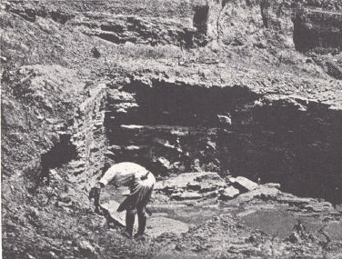 |
| PLATE XXX.—FIG. 3. Clay pit in Ripley
formation near Briensburg, Marshall County. Photos by Roberts. |
Ripley.—The name was proposed by Hilgard (1860) for beds exposed near Ripley, Tippah County, Mississippi. In contrast to the Ripley of Tennessee (Wade, 1926) marine fossils are unknown in Kentucky. Poorly preserved plant stems and leaves have been found in some of the clays of Marshall County.
The Ripley is well exposed in Galloway and Marshall counties and to a small extent in McCracken County in the vicinity of Paducah. It consists of clay and sand, sometimes indurated, and small amounts of free gravel. There is much lateral gradation. The clay and sand vary from white to grey, red, and purple. The clay is jointed. Mottled and variegated often cross-bedded beds of sand are common. Marcasite concretions occur in the clay and fragments of silicified wood in the sand. In the southern parts of Galloway County and the Purchase, in general, clay is subordinate. To the north in Galloway County and in Marshall County clay predominates and is of commercial value. The color varies from medium or dark grey to brown and black. It is commonly lignitic and often gritty. In contrast to the Lafayette coating of the sand grains by ferrous oxides is not very common.
A maximum thickness of 40 to 60 feet is known. The normal thickness is usually not in excess of 20 feet. The Ripley is best recognized by the association of clay and sand in lenticular form and by the physical character of the clay.
Footnotes
1 The source of much of this information in addition to references cited is an
un-published manuscript of the Kentucky Geological Survey by Roberts and
Meacham, The Geology of the Jackson Purchase Region, Kentucky.
2 First Biennial Report on the Geology of Alabama, pp. 118-120, Tuscaloosa,
1850. The term was given official use by Hilgard in 1860 (Report on the Geology
and Agriculture of Mississippi, 391 pp., Jackson, 1860). As used, the
Tuscaloosa was included and some of the upper beds were omitted.