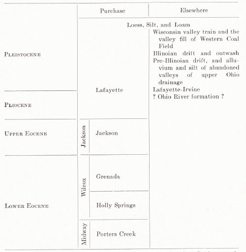
manuscript, Ky. Geol. Surv.).
|
|
| (After Roberts and Meacham, Geology of the
Jackson Purchase Region, unpublished manuscript, Ky. Geol. Surv.). |
The Tertiary involves only the Eocene and Pliocene, insofar as is known. Marine conditions apparently existed only in the Eocene, and then only in Porters Creek (Midway) time. Studies of the Tertiary of Tennessee were begun by Roberts and Collins in 1925 (Roberts and Collins, 1926), and these studies were then extended northward into Kentucky by Roberts and Meacham.
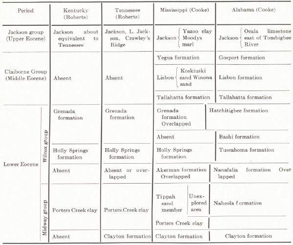 |
| Plate XXIX.—Fig. 2. Correlation of the
Eocene of Kentucky with that of Tennessee, Mississippi and Alabama (Roberts, 1931a). |
MIDWAY
Porters Creek clay.—This is a persistent unit and uniform in character. Clay comprises the greater part of the formation and is easily recognized by its color and habit of weathering. It is fine smooth-textured clay, which, when dry and comparatively fresh, is lead to dove grey in color. The wet clay ranges from dark grey to greyish black. An outstanding characteristic is the system of vertical joints and attendant conchoidal fracture yielding characteristic small blocks. Another feature is its porous nature making dry fragments appreciably lighter than other clays. It carries only a few indurated beds. Locally thin layers of fine sand are interbedded. Fossils are marine and usually poorly preserved moulds of gastropods and pelecypods. At only one locality (south of Paducah) are they known to be at all abundant. Fish scales have been found.
Sandstone dikes ranging up to 18 inches wide cut the Porters Creek at many points. These are composed of fine angular dark to light grey micaceous sand. They cut across the beds at all angles but have not been found cutting beds either older or younger than this clay. The same is true in Tennessee. They have been interpreted by Glenn (1906) as due to Eocene earthquake movement.
A thickness of 40 feet has been measured in Galloway and Marshall counties. The Porters Creek rests unconformably on the Ripley and similarly beneath the Wilcox.
WILCOX
Holly Springs formation (Lowe, 1913—from Holly Springs, Marshall County, Mississippi).—These sediments extend across Tennessee into Kentucky and disappear in McCracken and Ballard counties beneath younger sediments.
|
Plate XXX |
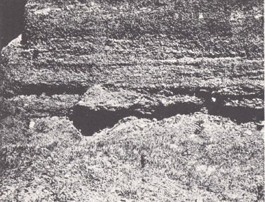 |
|
FIG. 1. Lafayette gravel, 8 miles east of Murray, Galloway County. |
 |
| FIG. 2. Holly Springs clay, Wickliffe, Ballard County. (FIG 3 in Ch.8) |
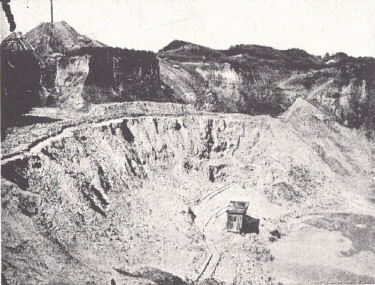 |
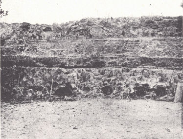
| FIG. 4. Holly Springs formation, Cooley clay pit north of
Mayfield, Graves County. Photos by Roberts. |
The Holly Springs consists of sand, clay, a small amount of clay conglomerate, and occasional thin seams of lignite and indurated ferruginous sand and clay. The sand ranges from coarse to fine, and is mostly quartz with small amounts of feldspar, muscovite, etc. It is greenish brown, occasionally grey, and to the south some is purple. Cross-bedding is common. The clay, like the sand, is lenticular. Some is smooth, light colored to white, and is shipped as ball clay. The rest varies from yellow to brown to almost black. Many beds yield beautifully preserved leaves, and to a small extent fruits and flowers, of which 257 species are known. These have been described by Lesquereux (1859) and Berry (1916). One of the best fossil localities is 1 mile west of Viola, Graves County, in the pit of the Kentucky Clay Mining Company.
The thickness is nowhere over 50 feet. Jointing in the clay is common. The Holly Springs and Grenada have been mapped as a unit (Wilcox) by Roberts, for in the absence of a well-preserved flora in the Grenada they are difficult of separation.1
Grenada.—The name was proposed by Lowe (1913). In Mississippi it carries a distinctive flora which may be recognized in Tennessee but fossils are unknown in Kentucky except for unidentifiable fragments of stems and leaves. The extent is more limited than that of the Holly Springs, but it outcrops in several places in Graves, Hickman, and Fulton counties. It unconformably overlies the Holly Springs in Mississippi and Tennessee and presumably does so in Kentucky.
The formation consists of sand and clay. The former is relatively clean, usually grey, the quartz angular, transparent, and with little mica present. Limonite concretions are occasionally present. The clay is usually light colored, some of it dove. The former is gritty and only the dove clay has much plasticity. The habit of weathering is similar to that of the Porters Creek clay. The most characteristic and reasonably persistent feature is the presence of small gypsum crystals with average length of about 2 millimeters. They are usually abundant and interfere with commercial usage. None of the clay is lignitic. Bedding is well developed in both sand and clay.
The maximum thickness observed in outcrop is 25 feet.
JACKSON
Jackson formation (Hilgard, 1860).—Loughridge (1888) used the name Hickman. It is exposed in Fulton, Hickman, and Carlisle counties in the bluffs of the Mississippi, and consists of clay and sand, the former dominating toward the south and the latter toward the north.2
The clay is smooth to gritty, well bedded, well jointed, dove to medium grey, and is rather suggestive of light blue limestone. It is indurated to a fair degree, but there is only a trace of calcareous material. Plants are found in the smoother variety. Small cavities occur some of which suggest an origin by decay of leaves and stems. The sand is very fine, angular, and lead to white grey. Most of it is evenly bedded, apparently without cross-bedding.
The formation is characterized by its plant remains, the extreme fineness and uniformity in texture of the sand with high percentage of quartz, and induration of the clay, which has a peculiar habit of jointing oblique to the bedding. The thickness does not exceed 40 feet.
PLIO-PLEISTOCENE
Lafayette.—The name Lafayette is from the county of that name in northern Mississippi and was first used by Hilgard (1891). Glenn (1906) regarded these beds as Pliocene. In Tennessee the term Plio-Pleistocene is used by Roberts, as apparently both epochs are represented. It mantles the whole Purchase, rests on anything from Keokuk up, and conceals outcrop about as completely as the glacial drift in Ohio and other states.
The Lafayette consists mainly of gravel, sand, and a little clay. The gravel phase is mainly chert with small amounts of quartzite and limestone. It is apparently derived from Mississippian and other cherts and represents terrace deposits. In size the pebbles range up to several inches, and are commonly coated with iron oxide, enough in some instances to cement them into a conglomerate. They are all well rounded or flattened in contrast to those of the Tuscaloosa.
The sand ranges from coarse to fine and has about the same composition as the gravel. It occurs either interstratified with the gravel or as a matrix for it. The grains are sometimes coated with iron oxide, giving a yellow to brown color. Bedding is well developed and cross-bedding is common. Large quartzite boulders that may be of glacial origin have been found in three places.
The formation is recognized by the weathered condition of the sediment, the brown to yellow color, coarse texture, and the well worn form of the gravels.
These widespread gravels of the Gulf Embayment are continued up the main stream valleys of the Ohio River and Kentucky River and are apparently continuous with the Irvine formation of Campbell (1898). This formation was described as "unconsolidated sand, gravel, and clay (some of it commercial)3 which originally covered the intermediate valley of the Kentucky River near the eastern edge of this quadrangle (Richmond),3 but which are now found capping the river hills—the few remnants of what was once an extensive and continuous surface." Hilltops sag well below the Lexington plain level in the vicinity of the Kentucky River forming a dissected terrace, indicating minor uplift and the forming of a broad valley prior to the main uplift and trenching of the river. Dating of these deposits can be done only with reference to the time of completion of the Lexington peneplain, regarded as mid-Tertiary. Near Irvine they have an altitude of about 900 feet. Such gravels occur at lower levels downstream—800 feet (plus) in Franklin County, 735 feet in Breckinridge County, and 625 feet near Hawesville, Hancock County. On down the Ohio the belt of gravel widens and occupies the whole area of hilltops between the Ohio and Green rivers. It is known as far up the Green River drainage as Warren County. In the Purchase the level ranges from 550 feet to 500 feet (Malott, 1922; Leverett, 1929).
The nature of the Irvine-Lafayette is determined by the source of detritus available upstream. Quartz pebbles from the Rockcastle, Caseyville, and other conglomerates are of course common. Geodes derived from Keokuk and Warsaw are particularly common in the Irvine of the Blue Grass. Farther downstream chert from the St. Louis and Ft. Payne becomes conspicuous. Considerable uncertainty has existed among writers as to the age, correlation, and nature of these deposits.
Ohio River Formation (Ashley, 1903).—The name was applied to considerable deposits of sand with some small quartz pebbles, often cross-bedded, found at scattered points in Harrison and Washington counties, Indiana. Cherty conglomerate locally occurs at the base. It occupies the upland about 400 feet above the Ohio River, but is not restricted to the vicinity of the river. The greatest thickness in Indiana is 80 feet.
Similar deposits of apparently the same formation occur in Meade and Hardin counties, Kentucky. At two points, where commercialized as glass sand, it occupies sinkholes in the St. Louis limestone. At Tip Top the sand has been opened to a depth of 50 feet; near Guston the thickness does not exceed 20 feet.
The origin and age of these deposits are not well known. Malott (1922) thought the Indiana deposits had the appearance of a beach formation. Butts (quoted by Leverett, 1929) suggested that they may represent cave fillings, perhaps derived from the erosion of the Cypress sandstone, and subsequently exposed on the upland behind Muldraugh's Hill. Leverett (1929) also mentioned hilltop deposits of molding sand near Newport and Covington that may be related to these Ohio River beds. They are 10 to 30 feet thick and at an elevation of 820 to 860 feet.
PLEISTOCENE
Pleistocene deposits include:4
I. Pre-Illinoian:
(a) Pre-Illinoian alluvium of the fluvial plains of the predecessors of parts of the present Ohio River drainage. Remnants of such gradation plains, though best developed upstream in southeastern Ohio, northeastern Kentucky, and West Virginia, have been observed along the Ohio River down to Breckinridge County 200 feet above the river (Leverett, 1929).
(b) Pre-Illinoian silt with a thickness up to 100 feet in the abandoned sections of the upper Ohio and its tributaries overlying the fluvial deposits. The silt is a matter of glacial ponding. Some Illinoian and possibly Wisconsin silt may be included (Leverett, 1929).
(c) Erratics of the Pre-Illinoian in the eastern Knobs and Eastern Coal Field. These include the ± 16-ton Epworth (Lewis County) boulder of schistose quartzite at 986 feet and the ± 3-ton Farmers granite gneiss boulder (Rowan County) at 700 feet (Jillson, 1924 n, 1, 1925d, 1927m). The position of the latter is such as to indicate that it was originally probably deposited at a higher level. According to Leverett (1929, p. 40) they "appear to have an average degree of weathering somewhat greater than that of the Illinoian drift pebbles.”' The Epworth boulder was deeply disintegrated. Microscopic study by Wright of these and a norite gneiss from Lawrence County seems to indicate their derivation from some area "northeast of a line from Ottawa to the southwest side of the Adirondack Mountains, and very probably from the area in Quebec between Ottawa and Quebec City." (Leverett, 1929, p. 44.)
Erratics are known in the Knobs of Meade and Bullitt counties at elevations up to 700 and 800 feet. There are reasons to believe (Leverett, 1929) that they were rafted there by floating ice. Boulders up to several feet in diameter have been found at Sturgis (Union County) and near Carrsville (Livingston County). Proximity to the Ohio River and their topographic position leaves the possibility that they also floated in on ice. This explanation was at first suggested by Jillson for the above mentioned erratics of eastern Kentucky but was later abandoned in favor of deposition by pre-Illinoian ice.
(d) A small area of deeply weathered till is known west and southwest of Covington on the ridges between Bromley Creek and the Ohio and Licking rivers at a level of 800 to 900 feet. Included stones are none of them as fresh as in the associated Illinoian drift, and limestone fragments have been removed by solution.
II. Illinoian:
Illinoian drift is found for a short distance south of the Ohio River from Oldham to Bracken County. It varies from scattered erratics up to 3 or 4 feet in diameter to local deposits of some thickness. It is rarely a factor in determining topography. At Cincinnati Fenneman (1916) described the till on the upland as varying from 0 to 10 or 15 feet thick. It is hard and blue, contains not more than 1 or 2 per cent igneous and metamorphic material and is highly calcareous except where leached near the surface.
 |
|
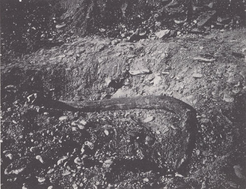
FIG. 10. Mammoth tusk in gravel pit near Cincinnati, Ohio |
In Carrol County just above the mouth of the Kentucky River, clay till fills a gap in the Ohio River bluff 40 to 60 feet above the Wisconsin fill. Split Rock in Boone County is a point of local interest. It is a mass of stony till detached from the main mass, and rises 100 feet above the river. The material is mainly local limestone with a few quartz, chert, and crystalline boulders. One-half mile north of Mentor (Campbell County) a drift-filled valley rising 160 feet above water level is shown in the Ohio River bluff. It marks the former outlet into the Ohio of a stream now a part of Twelve Mile Creek drainage. One mile east of Augusta (Bracken County) a similar till composed mainly of local limestone rises 150 to 175 feet above the Ohio River to form a barrier around which Big Brother Creek loops to enter the Ohio.
The Illinoian terrace along the Ohio River and tributaries from the north near Cincinnati is described by Fenneman (1916) at the 620- to 640-foot level. It consists of interbedded till and outwash. Evidence of this valley fill disappears downstream from Louisville, as the level comes close to that of the later Wisconsin fill. Theis5 finds some suggestion of it in Henderson County.
III. Wisconsin:
The Wisconsin ice sheet did not reach the Ohio River but gave rise to an outwash plain along that stream and tributaries from the north. At Cincinnati this terrace stands at 540 feet plus. Much of the business sections of Cincinnati, Newport, Covington, and Louisville stand on it. Theis6 recognized the same Wisconsin terrace in Henderson County at ± 390 feet, and another slightly lower. Alluvial fill in backwater from glacial flooding and alluviation of the Ohio Valley are found in tributaries from the south. These are particularly conspicuous in the main stream valleys of the Western Coal Field to depths of up to 200 feet. Illinoian fill may also be involved.
Loess occurs as a blanket deposit in the counties bordering the Mississippi and Ohio rivers in the Purchase region and Western Coal Field. Away from the river it grades into a loam. East of Green River there is little typical loess but instead some silt or silt loam where slopes are gentle enough to retain it. There is some near Louisville, somewhat coarser and used as molding sand. In the area of the Illinoian drift a thin coating of silt occurs over the till sometimes showing an intervening soil bed correlated with the Sangamon. In his Henderson County report Theis7 interpreted the loess as originating in several stages of the Pleistocene.
Footnotes
1 These two formations along with the Jackson were formerly grouped together as
the Lagrange. Safford: On the Cretaceous and Superior Formations of West
Tennessee, Amer. Jour. Sci., Ser. 2, Vol. 37, pp. 360-372, 1864.
2 Roberts and Meacham, Geology of the Jackson Purchase Region, unpublished
manuscript, Ky. Geol. Surv.
3 Remarks in parenthesis inserted by the writer.
4 Leverett (1929) gives a comprehensive summary of what is known of these
deposits.
5 Geology of Henderson County, Kentucky, unpublished manuscript, Ky. Geol.
Surv.
6 Ibid.
7 Ibid.