PLATE XXXI.—Structural map of Kentucky. Key bed—top of Black shale (after Jillson, 1931)
Cincinnati Arch.—The Cincinnati arch is one of several structural highs which determine the distribution of outcrop in the central interior of the United States. The axis passes through central Tennessee and Kentucky in a north by east direction and splits in northern Kentucky with one limb passing on each side of the Michigan Basin. To the west, as the structure rises again on the flank of the Ozark uplift, a part of the area of Paleozoic outcrop is buried beneath Cretaceous, Tertiary, and later beds of the Gulf Embayment.
|
|
|
PLATE XXXI.—Structural map of Kentucky. Key bed—top of Black shale (after Jillson, 1931) |
Two domed structures are developed along the axis: (a) the Jessamine dome of central Kentucky (from Jessamine County); and (b) the Nashville or Rutherford dome of central Tennessee. The two are separated by a sag (saddle) in the structure centering over Cumberland County, Kentucky. The Jessamine dome dominates the structure of the greater part of the state. Dips average 20 to 30 feet per mile to the east and west and about 10 feet to the mile north and south along the axis.
The oldest exposed rocks in the state are the Camp Nelson beds, which outcrop with maximum exposed thickness in the Kentucky River gorge at Camp Nelson from which they take their name. However, the structure rises a little higher for a half dozen miles southward to the vicinity of Burdett Knob, Garrard County, where the dome is cut by the Kentucky River fault. This fault system intersecting the Arch high on the structure abruptly terminates the area of outcrop of the pre-Cincinnatian to the southeast and south, giving in effect a truncated half dome. The deep trenching of the Cumberland River in the Mississippian plateau region of the saddle exposes Cincinnatian strata again in the valley bottoms. Here they directly underlie the Black shale.
The Arch has been the significant feature in the determination of the regional topography of much of the state. It has been an important factor in determining the distribution of oil and gas production and of other resources.
Two main periods in the building of the dome are recognized; one in the pre-Mid-Devonian and a second at the time of the Appalachian Revolution. Notes on the progressive development of the Arch have appeared in the literature for many years and in Schuchert and Dunbar's Historical Geology the development of the Arch is given as having been initiated in the Mid-Ordovician. Wilson (1935) discussed in some detail evidence of early Mid-Ordovician uplift in the region of the Nashville dome. Insofar as the Jessamine dome is concerned, significant warping is not indicated until the Mid-Devonian.
Some points of interest involving earlier rocks include:
(a) Meacham (1933) recognized a notable gap in the pre-Trenton section encountered in drilled wells in central Kentucky. However the more recent work of Freeman (1939a) seems to indicate that Meacham was in error in his interpretation of the section and that a more or less uniform Stones River-Lowville succession, thickening to the southeast, is present in central Kentucky.
(b) The writer (1938c) has shown the relationship of the Lexington limestone to later Trenton rocks to be such as to indicate a shallow east-west syncline through the central Blue Grass region (fig. 3).
(c) The distribution of the Perryville is in keeping with pre-Cynthiana arching in the region of the crest of the Jessamine dome. The occurrence of the Perryville is more or less limited to the western and southern flank and the more restricted occurrence of the Cornishville member farther out on the flank to the southwest and south suggests regressive overlap and is more or less in keeping with the Cynthiana record. The formation is unknown on the east except in the West Hickman graben and just to the east of it, where the beds dip in toward the downfaulted block. The preservation of this remnant of Perryville between the Lexington and Cynthiana in this structural low suggests the beginning of this structure in the pre-Cynthiana.
(d) The Cynthiana formation shows a basal overlap from all directions on to an area centering around Lexington and Frankfort (fig. 4 and p. 21). But the uppermost member of that formation (Rogers Gap) shows uniform submergence within the area of outcrop.
(e) The basal Eden (Fulton) also shows a minor "island" area.
The significance of these features is open to question. They do not necessarily imply the beginnings of the Jessamine dome and may represent either: (1) minor high spots on a sea floor left temporarily bare with a lowering of sea level; or (2) minor up warps which may have been only a few of many. They assume apparent significance only because they coincide geographically with the position of the later movement, and the involved beds and their structural relationships are exposed to view only in this central are.
However, there does seem to be a contrast with the pre-Trenton. Instead of the more or less uniform Stones River-Lowville, the section has become one of changing facies, unconformities, and overlaps.
(f) Foerste (1906, 1931, and 1935) called attention to the similarity of Brassfield faunas to the east and west of the Arch. Later dissimilar faunas of the Clinton and Niagara he interpreted as probably due to a barrier along the rising Arch. The barrier is not regarded as involving necessarily complete east-west isolation but sufficient at least to obstruct free faunal intermigration.
The most striking unconformity of the Kentucky Paleozoic, except that of the Mississippian-Pennsylvanian contact, is the overlap of the Mid-Devonian limestone on to successively older formations as the axis of the Arch is approached. Between Crab Orchard and Irvine the Boyle limestone (Hamilton) rests on the Crab Orchard shales (Clinton). Toward the axis the Boyle overlaps the Crab Orchard and Brassfield to rest on the Richmond and Maysville. A similar overlap is shown on the west. To the east under cover the Bisher (Clinton) and Lilley-Peebles (Niagaran) dolomites come in below the Boyle within 5 miles of outcrop. Farther east Ballard (1938) has shown that the Cayugan and Helderberg are also added to the section as the limestone succession between the Black shale and Clinton thickens to 500 and 600 feet. This overlap by the Mid-Devonian from Helderberg to Maysville would seem to indicate an early Arch not incomparable in extent to the later fully developed one.
Although the Boyle limestone occurs rather consistently in the region of the crest of the dome, it is in places cut through by the Ohio shale. In Ohio and Tennessee and from drill records in places in Kentucky the Black shale seems to be the overlapping formation. Local folding and erosion in the pre-Ohio is known from drill records and samples in a number of oil pools in the state. Among these may be mentioned a number of the so-called trend pools where production seems to be controlled by the beveling of several limestone formations by the Ohio shale.1 The direction of these trends, and the general alignment of the Corniferous pools of the state as well, is northeast-southwest parallel to the axis of the Rockcastle River uplift and the Appalachian folds to the east.
That the early "upwarp" does not necessarily mean an early island condition of any great extent or height is shown by the presence of the Ohio and New Providence (lower Waverly) formations locally preserved on the crest of the Arch in downfaulted blocks. The most prominent of these is along the Kentucky River fault zone at Burdett Knob in Garrard County, a knob capped with Waverly. It is believed that the St. Louis limestone formerly capped this knob and that this limestone thus formerly extended over the Arch. This belief is based on the presence of Burdett Knob as a monadnock rising above the Lexington plain (uplifted Mid-Tertiary peneplain). Nothing in the present lithologic constitution of the Knob explains such a monadnock. A former cap rock subsequently removed by erosion must be assumed, and on the basis of the exposed section in the Muldraugh's Hill cuesta 20 miles to the south, this would seem to be the St. Louis limestone.
The contact of the Ohio shale and underlying Richmond at Burdett Knob shows a buried surface with local relief of 20 to 30 feet, as the uppermost Ordovician present ranges from upper Arnheim to Waynesville. This could, of course, be due to mild angular discordance.
There is some evidence of a former Pottsville cover in outlying remnants of Pottsville conglomerate and sands far removed from the Pottsville Escarpment and residual conglomerate boulders on the uplands.
The Pennsylvanian-Mississippian contact is one of marked disconformity and one of considerable relief as shown in a number of known Pottsville-filled valleys (see p. 96). This uplift, though, was a regional upwarp unrelated to any movement of the Cincinnati arch. Stouder (1938) has also called attention to a somewhat similar erosion surface between the Ste. Genevieve and Mooretown sandstone (Renault). Further consideration of the development of the Cincinnati arch involves also the "Eastern Kentucky geosyncline" and Western Coal Basin.
Were the Eastern and Western Coal Fields (Appalachian and Central Interior) Formerly Continuous Across the Arch?—It is generally regarded that this was the case. Widespread submergence in the axial region is known to have followed the pre-Mid-Devonian folding. Miller (1910) suggested that a series of outliers represented the former continuity of a large Pennsylvanian sandstone-filled channel from Edmonson County to Laurel County in the east. He further correlated the two conglomerates of the Caseyville of the Western Field with the Rockcastle and Corbin conglomerates of the Eastern Field. Ashley (1907) found little evidence of such a connection at least across Indiana and Ohio in the post Mansfield (Sharon-Rockcastle). Wanless (1939) found some similarities in the lower Pennsylvanian section of the Appalachian Field with the probable equivalents in the Central Interior Field. This suggests former continuity of the two coal-producing areas. These include:
|
Appalachian Field |
Central Interior Field |
| (a) Middle Kittanning coal of Ohio and Pennsylvania. | Kentucky No. 11, (Illinois No. 6 and Indiana No. VI). |
| (b) Van Port limestone and beds beneath of Ohio and Boyd counties, Kentucky. | Seahorne limestone, et al., of western Illinois. |
| (c) Putnam Hill limestone of Ohio. | Stonefort limestone of southern Illinois |
| (d) Fire Clay coal of eastern Kentucky. | Upper DeLong coal of Illinois (also a widespread clay—not fire clay— parting). |
| (e) Lower Mercer limestone (Ohio). | Seville limestone (western Illinois). |
| (f) Certain shales below the Campbells Creek coal (Kentucky, West Virginia, and Virginia). | Similar shales below the horizon of the Finnie sandstone. |
| (g) Rockcastle and Corbin conglomerates (eastern Kentucky). | Two conglomerates of the Caseyville of western Kentucky. |
| (h) Sharon ore (Ohio). | Sellers limestone (Illinois). |
| (i) Marine conglomeritic Harrison ore (Ohio). | Marine zone near base of Wayside formation in southern Illinois. |
Eastern Kentucky Geosyncline.2—The structure referred to as the Eastern Kentucky geosyncline is hardly of the order of magnitude or nature of a geosyncline (a progressively sinking trough accommodating a great thick-ness of sediment), but the term has been used for some time. It constitutes the southern end of the Pittsburgh-Huntington Basin in which the Permian is preserved in West Virginia, Ohio, and Pennsylvania. In Johnson, Magoffin, Lawrence, Morgan, and Floyd counties this syncline is crossed by the Paint Creek uplift with a general north-south axis, which isolates its southern extremity as a closed basin with approximate closure on the 1,000-foot contour (Fire Clay coal horizon). This basin centers in Breathitt, northern Perry, and northwestern Knott counties.
 |
| Plate XXXII.—Geologic structure map of eastern Kentucky. Key bed: Fire Clay coal. (Compiled from Kentucky Geological Survey county maps) |
Attention is called to the fact that this reversal of eastern dip, as drawn on the Fire Clay coal (pl. XXXII), is not reflected in the structure of the Black shale (pl. XXXI [at top of page]). This lack of accordance between surface and subsurface structure is interpreted as due to progressive sinking to the east and southeast, particularly in the early Pennsylvanian, along the western flank of the Appalachian geosyncline.3 It is indicated in the tremendous increase in interval between the Fire Clay coal and the base of the Pottsville toward the southeast. This coal at the time of deposition represented a topographic as well as stratigraphic plane. The later forming of the Eastern Kentucky geosyncline as portrayed on the Fire Clay coal, merely flattened the convexity of the Black shale developed by the progressive subsidence mentioned above (fig. 11). But prior to the final folding an eastern flank of the Jessamine dome was well developed as a result of this and earlier subsidence. On surface outcrop the Jessamine dome terminates to the east with the trough of the Eastern Kentucky geosyncline. In subsurface at the horizon of the Black shale or below, this structure is continued eastward to the Pine Mountain thrust. In considering the Pittsburgh-Huntington Basin, no suggestion of progressive development is found in Kentucky but rather to the contrary. This basin is certainly a product of the Appalachian Revolution.4 This is shown by the Pennsylvanian section, which, though of greater stratigraphic range (involving the Pottsville-Conemaugh), is represented by a thickness of a few hundred feet as compared to a few thousand feet of Pottsville to the southeast outside the basin, thus a reversal from something of a condition of structural high to structural low.
 |
|
FIG. 11. Diagram to explain the disappearance with depth of the eastern Kentucky geosyncline (McFarlan, 1939) |
Western Coal Basin.—This is a local term covering that part of the Eastern Interior Coal Basin in Kentucky. The Illinois Basin, as the term is used, is bounded on the south by the Rough Creek uplift and thus, does not include the southern part of the larger basin.
 |
| PLATE XXXIII.—Pre-Chattanooga formations and
Mid-Devonian overlap in the Western Coal Basin (adapted from work by L. B. Freeman) |
In regard to this basin Russell (1932, 1931) recognized differential settling as early as the Devonian. Devonian, Mississippian, and Pennsylvanian strata thicken in general toward the central part of the basin. Weller (1936) called attention to the early and progressive development of the Michigan Basin, and similarly an early development of an Illinois basin which extended farther to the south than the present area of Pennsylvanian outcrop. Russell (1932) found some suggestion that the Rough Creek fault movement may have begun in the Mississippian. Evidence consisted of the thin sections of that system encountered in some drilled wells on this structure.
Freeman (1939, 1941) has shown a well defined pre-Onondaga (Grand Tower-Jeffersonville) basin. The general stratigraphic setup is shown on plate XXXIII adapted from that author's work.5 To it sections in outcrop high on the Arch have been added. The large scale stratigraphic wedging up the dip with overlap by the Onondaga and in turn by the Chattanooga shale is important in connection with the Corniferous producing areas of western Kentucky. Ancient shore lines along the flank of the Arch, involving primary or secondary porosity or both, are part of the picture.
Ballard (1938) recognized a western basin in the Mississippian and Pennsylvanian with some shifting of the deeper part from time to time. In the Chester it was in Gallatin County, southern Illinois, which was north of its position in the Pennsylvanian but corresponded with that in the Meramec. In the Osage it was listed as located in Union County, Illinois.
The coal basin may be regarded as having been shaped at the close of the Paleozoic from a part of an earlier and larger geosynclinal area.
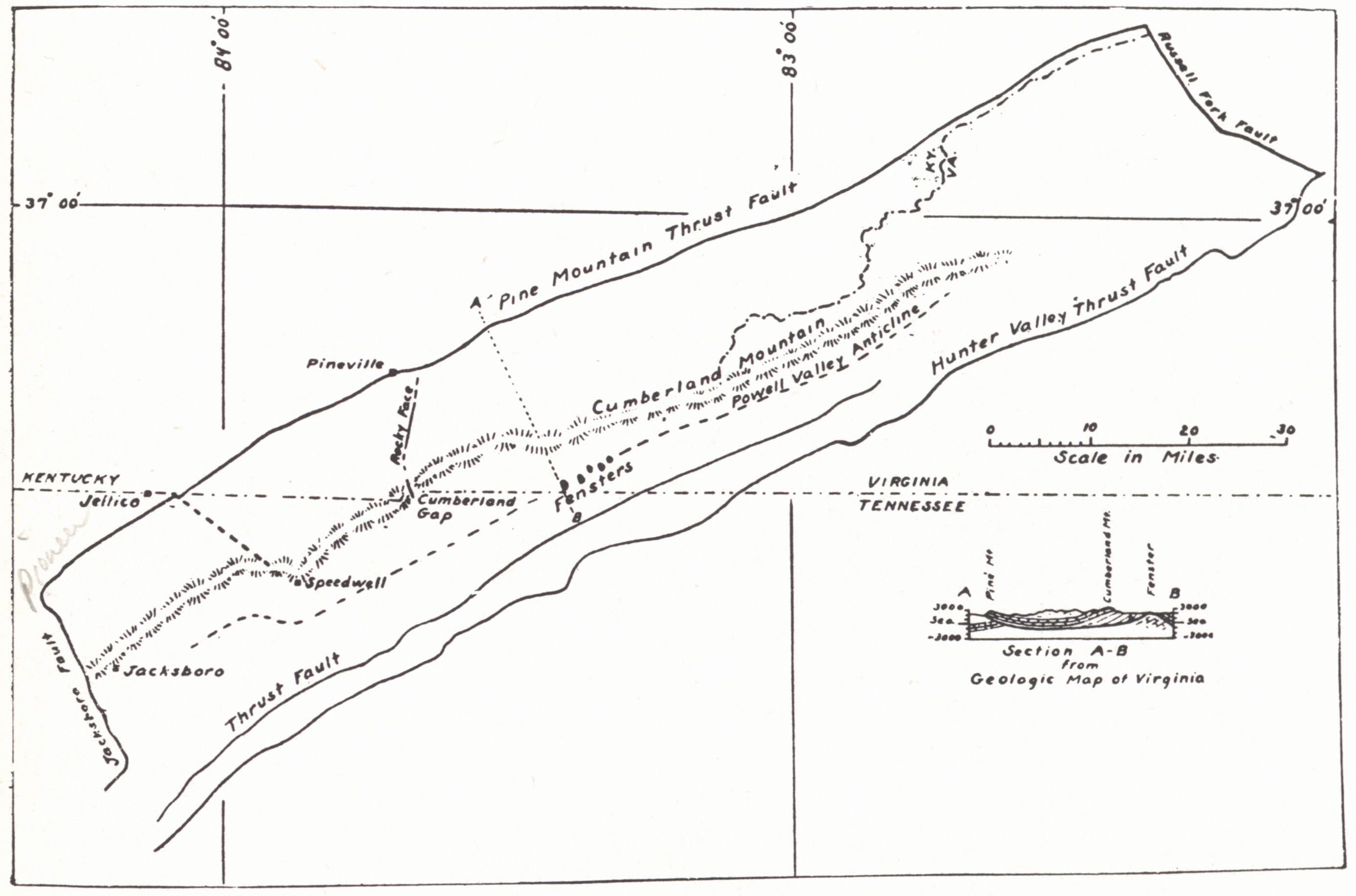
Pine Mountain Overthrust (Cumberland thrust block).—The thrust block, the easternmost of the "Newer Appalachian" structures, has been described in some detail by Wentworth (1921), Butts (1927a), and Rich (1933, 1934). It has been defined as bordered by the Pine Mountain fault (northwest), Jacksboro fault (southwest), Russell Fork fault (northeast), and Hunter's Valley fault (southeast). The last-named fault parallels and overlies the Pine Mountain thrust. The Jacksboro and Russell Fork faults along with the Pine Mountain fault may be regarded as constituting the continuous trace of one fault plane, which turns up sharply at each end to form the sides of the block. Rich (1934) has used the term "tear fault" for them. The movement of the Russell Fork fault is dominantly horizontal and to the northwest, and with only small vertical displacement. It differs from the Jacksboro fault in being high angled with a dip of 75 to 90 degrees to the southwest. The low saddle at Skegg Gap on Pine Mountain is described as formed in the crushed and weakened rocks along this fault.
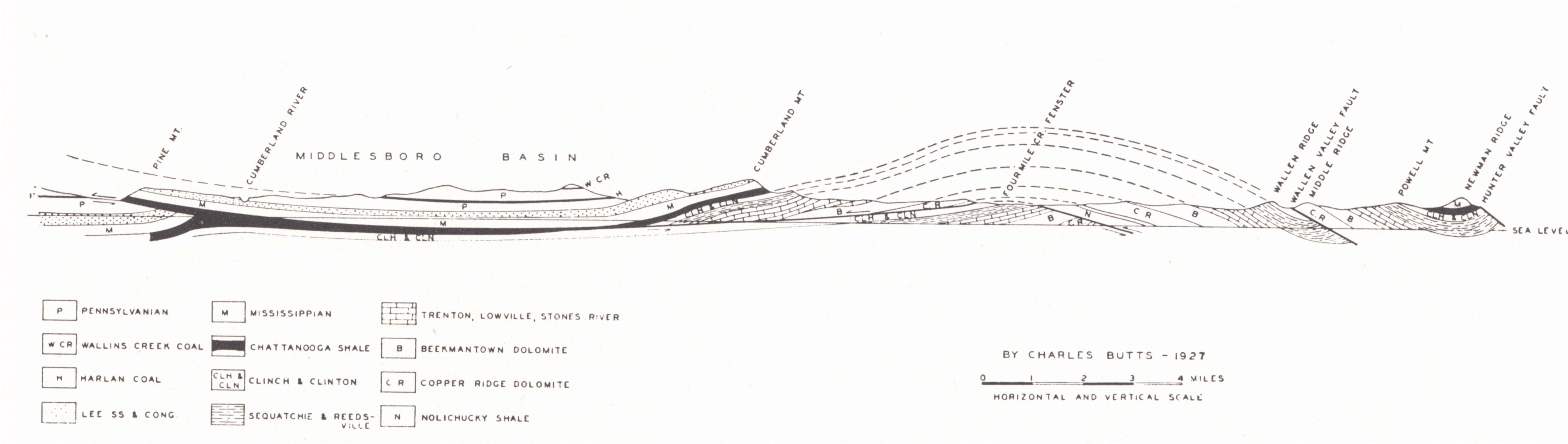 |
| FIG. 12. Cross-section showing fenster in
Cumberland overthrust block (Butts, 1927a). A fault on the southeast flank of Cumber¬land Mountain at Cumberland Gap and not shown in this diagram causes a repetition of outcrop of the Mississippian limestone and Waverly. This also brings down the Lee to form Powell Mountain which parallels Cumberland Mountain to the southwest of the Gap (Middlesboro topographic sheet). The fault, with downthrow to the southeast, apparently displaces the overthrust. |
 |
|
FIG. 13. Cumberland overthrust (Rich, 1933) |
The overthrust along the northern end of the block is about 2 miles; at the Jacksboro end about 10 miles (Wentworth, 1921). Lateral overthrusting, mainly at the southern end but to some extent also in the Russell Fork fault, resulted from the converging of the two bordering faults toward the northwest. Four thrust planes are involved at the southern end of the block (Wentworth, 1921), but the structure becomes simpler to the north. Where it outcrops in the face of Pine Mountain at Pineville, two thrust planes are well shown in the railroad cut exposures and face of the Cumberland River gorge.
Butts (1927a) described three fensters a few miles to the east of Cumberland Gap in the vicinity of Rose Hill, Lee County, Virginia, in addition to an earlier known one, in which the upturned and outcropping Pine Mountain fault exposes Clinton and Cincinnatian rocks beneath upper Cambrian limestone and dolomite. The fensters occur along the axis of the broad Powell Valley anticline in which the opposing dips in the overthrust rocks on each side of the axis are about 15 degrees. The northwest thrust at this point is about 7 miles.
The thrust plane "certainly cuts as deep as the Chattanooga shale, because the Chattanooga is brought up to the surface above it all along the northwest base of Pine Mountain. There is no evidence, however, that the thrust plane cuts into or below the Clinton formation, except toward the southwest end of Pine Mountain in Tennessee where, as mapped by Keith in the Briceville Folio, the Clinton is brought up to the surface above the fault" (Butts, 1927a, p. 9). The Clinton is not known to outcrop in the face of Pine Mountain in Kentucky. Butts regarded the Chattanooga as a reasonable position in the section for the thrust plane-a "zone of weakness on which yielding and movement might easily have taken place." A well with oil at 1118 feet in the Trenton was recently drilled by Floyd Fitch in the fenster southeast of Ewing.
The thrust block is broken in three wedge-shaped segments by two transverse shear zones similar to those at the ends:
(a) A zone running from Speedwell northwest toward Jellico Gap in Pine Mountain.
(b) The Rocky Face fault extends north from Cumberland Gap along the western side of Rocky Face to the vicinity of the Cumberland River Gap at Pineville. "The block between these two shear zones has the form of a wedge pointing southeastward and appears to have been moved north-westward a shorter distance than the blocks on either side" (Rich, 1933, p. 1227). Rocky Face is a prominent westward facing scarp made by the conglomeritic sandstone of the Lee formation. It outcrops in an elongate half dome bordered by steep thrusting on the west side. Ashley and Glenn (1906) estimated the north-south shortening to have been 1,300 to 2,000 feet. The upward thrust toward the west bringing the Lee to the surface is similar to that at the Jacksboro fault though not so great and was brought about by the differential northwest movement of the adjoining wedges. This fault zone is a part of the main structure and was formed at the same time (Rich, 1933).
In a more recent paper Rich (1934) called attention to the superficial nature of the structure shown in beds above the thrust plane, these structures being confined to the thrust block and not extending below the fault plane. The development of the Powell Valley anticline he explained as a result of the faulting. The arching was accomplished by an upthrust as the fault plane jumped from one gliding plane in the section to a higher. The warped fault plane might well be interpreted, however, as curvature due to the tendency of the fracture (fault) to follow the anticlinal structure (grain) of the rock.
Wanless (1939, p. 7) called attention to the contrasting succession of Pennsylvanian strata on opposite sides of the Pine Mountain fault and referred to this structure as "contemporaneous with Pennsylvanian sedimentation." The section to the southeast is much thicker, in places double or more. Similar difficulties are encountered in attempting to correlate coals across the Rocky Face fault but the difference in thickness, while present, is not so striking.
Middlesboro Basin.—As used in a restricted sense, the Middlesboro Basin is a roughly circular topographic alluvium-filled basin west of Cumberland Gap occupied in part by the city of Middlesboro. There is no structural reason for its existence other than the observed crushing of the rocks in that vicinity by the Rocky Face movement, which rendered it subject to more rapid erosion. Rich (1933) pointed out the general convergence of drainage lines to Cumberland Gap prior to piracy. The resulting more concentrated local erosion may well have removed the more resistant rocks higher in the section, so that in a later cycle degradation was more easily accomplished. The great depth of alluviation, though, must be accounted for. This according to Ashley and Glenn (1906) is at least 30 to 40 feet and may be as much as 175 feet if records of a reported drilled well are correct. They regarded necessary (a) upward movement along the fault at Rocky Face where crossed by Yellow Creek which drains the basin, or (b) a local sinking of the basin, or (c) a combination of the two. In any case "it is almost certain that there have been earth movements of some magnitude in this region, probably as late as Pleistocene or late Tertiary" (Ashley and Glenn 1906, p. 28).
Rich (1933) offered an attractive hypothesis to account for such recent movement. Since the Rocky Face fault terminates downward in the Pine Mountain thrust and is an integral part of this block, it cannot be regarded as an independent zone of weakness along which there may have been later movement. Further, since the Pine Mountain thrust approaches the surface and is even exposed at places (fensters), there can have been no recent renewal of movement along this thrust. He (1933, p. 1229) regarded it likely that "a dome, held up by the competent Lee and Newman formations would have been produced on the site of the Middlesboro basin" caused by stresses and movement associated with the development of the Cumberland Mountain monocline and Rocky Face fault zone. This dome he regarded as likely to have been almost without support from below but held up by the Lee and Newman limestone formations which formed its lower part and were continuous over a large area outside the dome. With removal of these beds south of Cumberland Mountain in the region of the Powell Valley anticline, sinking was facilitated and accomplished by a southeast retrograde movement along one of the shale zones as a gliding plane. Settling would be accompanied by minor lateral thrust which may well have produced some rise along the Rocky Face shear zone. The movement is thus regarded as one of readjustment.
Paint Creek—Warfield Anticline6—This northeast-southwest regional structure is known under several local names for different parts of it. The Irvine-Paint Creek fault and anticline is an east-west anticline accompanied by normal faulting and is an important Corniferous oil-producing structure. It extends eastward into the region of the Paint Creek uplift. The latter is a north-south anticline involving about 250 feet of closure (pl. XXXII). It is important in Weir oil and gas production (p. 355). An interesting feature is the early and progressive warping so that there is considerable divergence between surface and subsurface structure. Wanless (1939) called attention to this structure as the boundary separating two natural coal districts, between which there are striking differences in the section and resulting difficulty in correlation. The name Warfield anticline is applied to a continuation of the general Irvine-Paint Creek structure as it crosses Martin County into West Virginia. It is an important gas producer.
Rockcastle River Uplift.—This structure is described by Jillson (1926) and shown in the structural maps of the several counties involved. It is a closed anticline about 30 miles long and 10 miles wide, involving parts of Laurel, Clay, and Owsley counties with reversal up to 230 feet and maximum closure of 80 feet. High points along the axis are found in closures of 70 feet, 80 feet, and 20 feet each. No faulting is involved. Jillson (19r26) found some evidence suggesting pre-Pennsylvanian movement with more marked structure in the Big Lime than the Pennsylvanian. Such well records as were available showed a general "shortening" of the Coal Measure section as the crest of the Rockcastle uplift was approached. Some Corniferous gas has been found on the structure.
 |
|
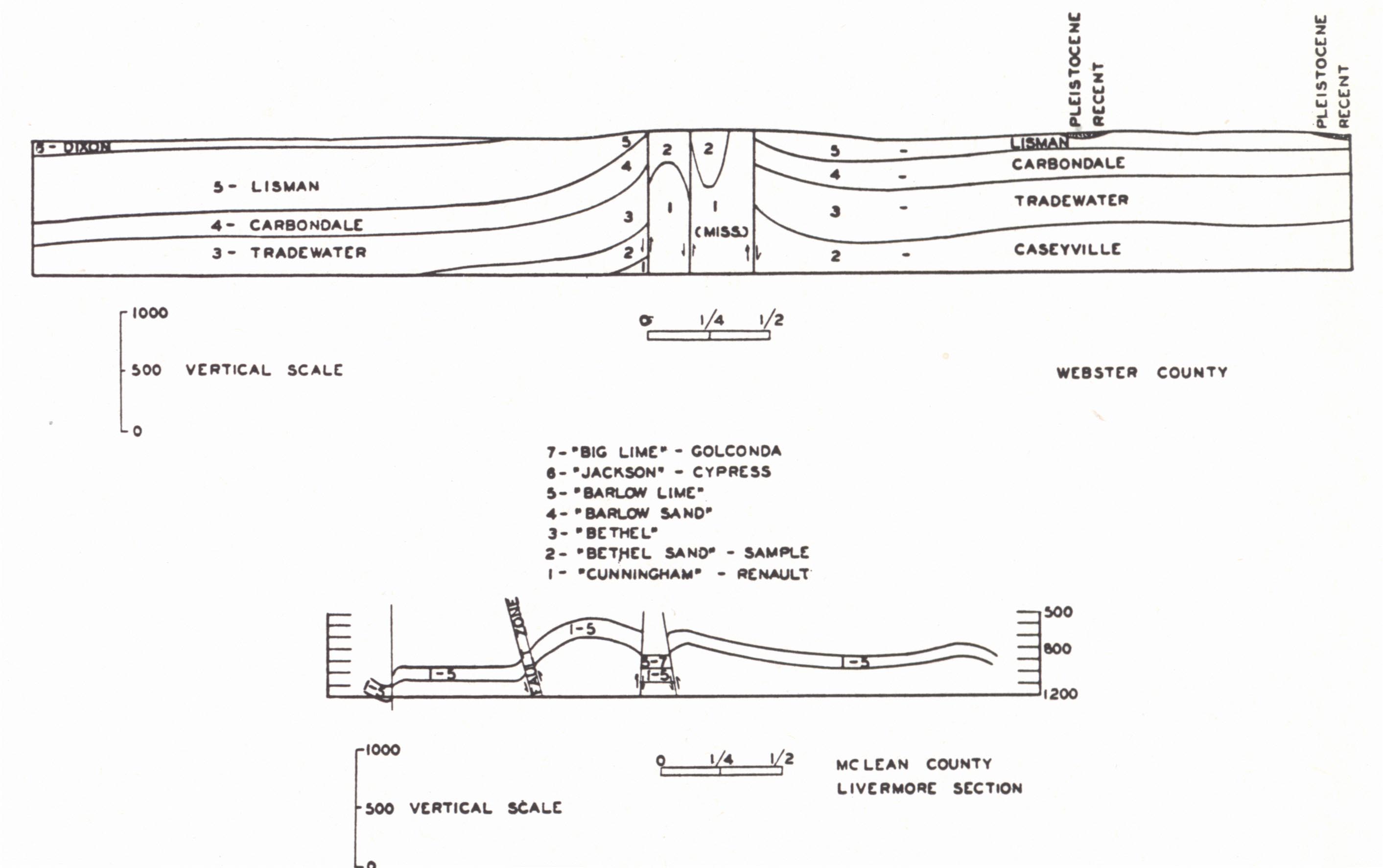
FIG. 14. Rough Creek fault (Webster County
after Glenn, 1923; McLean County |
Rough Creek Fault Zone or Uplift.—This structure was named the Rough Creek anticline by Norwood (1884) and is an eastward continuation of Owen's (1856) Shawneetown fault (= Gold Hill fault). It is an east-west structure extending from Grayson County to Webster and Union counties and divides the Western Coal Basin into two parts, the northern one of which is a part of the Illinois Basin. It is a structural uplift varying greatly in detail from place to place, but typically an anticline or series of steep anticlines with reversed faulting from the south accompanied by en echelon normal faulting. Uplift varies from a few hundred feet to 1500 and 2500 feet or more (Glenn, 1922) bringing the Caseyville sandstone and even Mississippian beds again into outcrop. The highly deformed sandstones near the fault plane are commonly more highly indurated, in some instances quartzitic. Russell (1933 and 1938) saw a suggestion of pre-Pennsylvanian movement in the thinner sections of Mississippian encountered in some wells drilled on this structure, but Wanless (1939) found essentially the same Pennsylvanian succession on opposite sides of the structure, which minimizes the probability of progressive development.
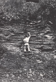
Kentucky River Fault.—The Kentucky River fault is a zone of en echelon normal faults which may be traced from the vicinity of Mt. Sterling in Montgomery County southwest to Lincoln County. Northward its continuation is recognized in the monocline of the Ragland Oil Field of Bath County. Southeast of Danville faults break off to the west, and one following near the base of Muldraugh's Hill (fault line scarp) may be traced to the vicinity of Lebanon, Marion County. Through much of the course of the Kentucky River fault zone the structure is a graben. A conspicuous feature is the commonly well-developed dip beyond the secondary or outer fault, or outside the single fault where but one is present. This is well shown in the exposed section at Agawam Station, Clark County (fig. 5) and along the southern border of the Blue Grass (fig. 15). Here there is a more downward movement in the flexing of the beds than in the fault displacement itself. The fault over part of its course rather sharply marks off the Inner Blue Grass, and forms a sharp boundary between the Blue Grass and the Knobs elsewhere. Here the belt of Knobs is quite narrow. Maximum displacement is at Burdett Knob where the Ohio Shale and Waverly have been faulted down 500 to 600 feet in contact with the Lexington limestone.
| PLATE XXXIV | |
 |
 |
| FIG. 1. John
Burdett barite vein along one of the Kentucky River faults, exposed on Boone Creek about 4 miles northwest of Lancaster, Garrard County. The fault forms the eastern margin of a graben in which the Million on the west (left) is downfaulted against the Perryville (right). Barite occurs as both a fissure filling and replacement and is associated with calcite, sphalerite, and a little fluorspar. |
FIG. 2. Sandstone dike cutting
the Jessamine limestone in a road cut on U. S. Highway 25 at Clay's Ferry in northern Madison County about 250 feet from the fault on the downthrow side. The sandstone is rather coarse grained and angular with calcite cement. It is interpreted as an earthquake fissure filling and the sand as Mid-Tertiary (Irvine). It is suggested (see text) that the fissure was opened as a result of Mid- Tertiary rupturing of the Kentucky River fault along with uplift of the Lexington peneplain. |
 |
|
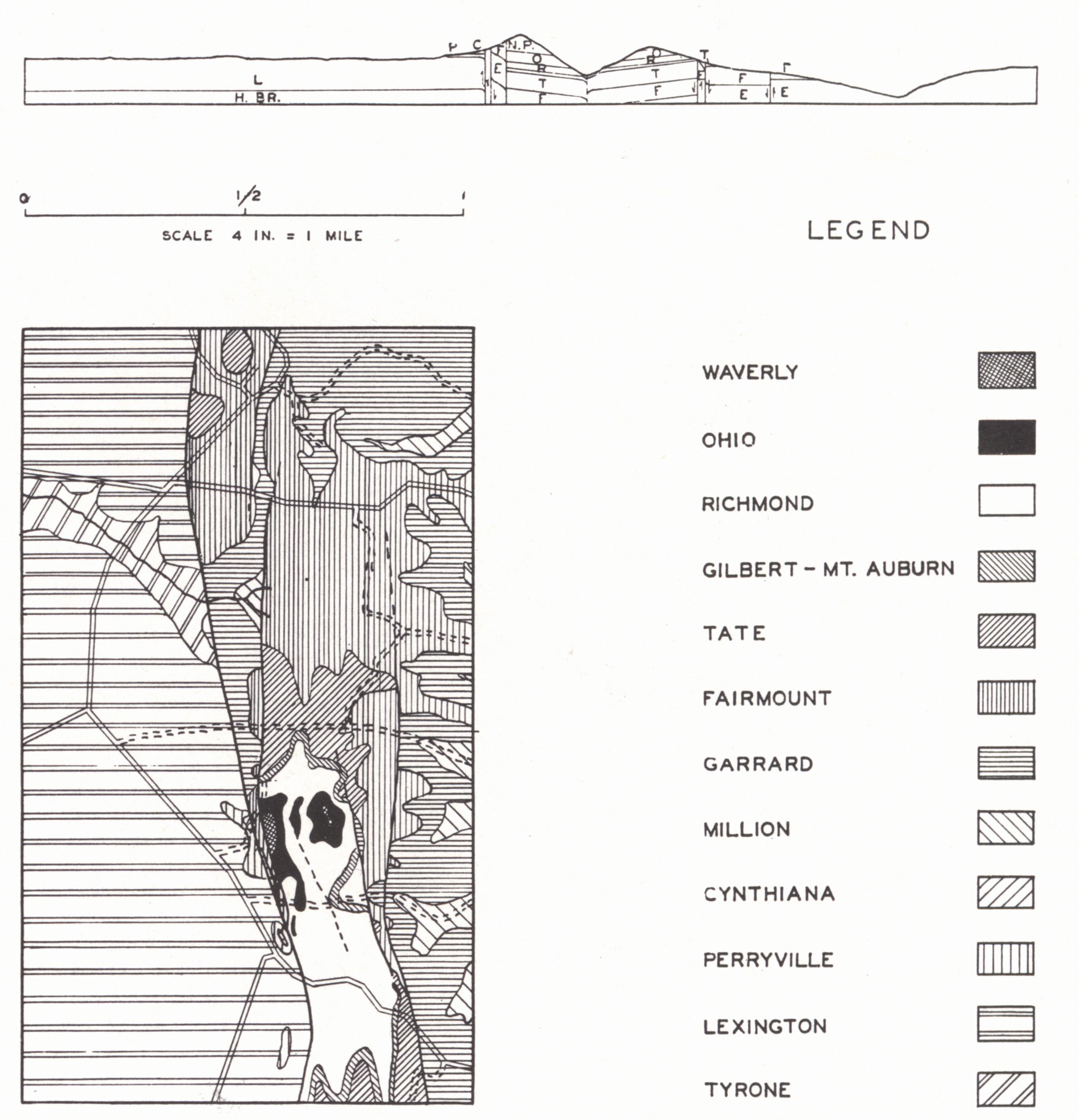
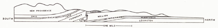
| FIG. 3. Geologic
map and sections of the Kentucky River fault zone at Burdett Knob and vicinity, northern Garrard County. |
|
There seems to be some relationship between this fault and the Kentucky River for that stream, entering the Blue Grass from the southeast, veers sharply to the southwest and follows the fault zone for some miles before again resuming its normal course to the north. In this distance the river crosses the fault nine times. The valley varies from broad and open, where carved in the Lexington-Eden, to a gorge, where carved in the massive limestones of the High Bridge rocks.
 |
|
FIG. 15. Structure section 2 miles east of
Parksville, Boyle County, Kentucky, showing Kentucky River fault bordering
Muldraugh's |
At Clay's Ferry in northern Madison County a sandstone dike a few inches across occupies a joint 250 feet south of the fault. The sand has been cemented with calcite. The dike is interpreted by the writer as Irvine sand washed into an "earthquake fissure" resulting from renewed though minor movement along the old fault accompanying the late Tertiary (post-Irvine) uplift of the Lexington plain. Loose blocks of sandstone up to a foot or more across derived from the weathering of a similar dike have been found along the same fault near Valley View in southwest Fayette and southeast Jessamine counties. The fault may be traced for a distance of about one-half mile by the line of loose crumbling sandstone blocks.
| PLATE XXXV | |
 |
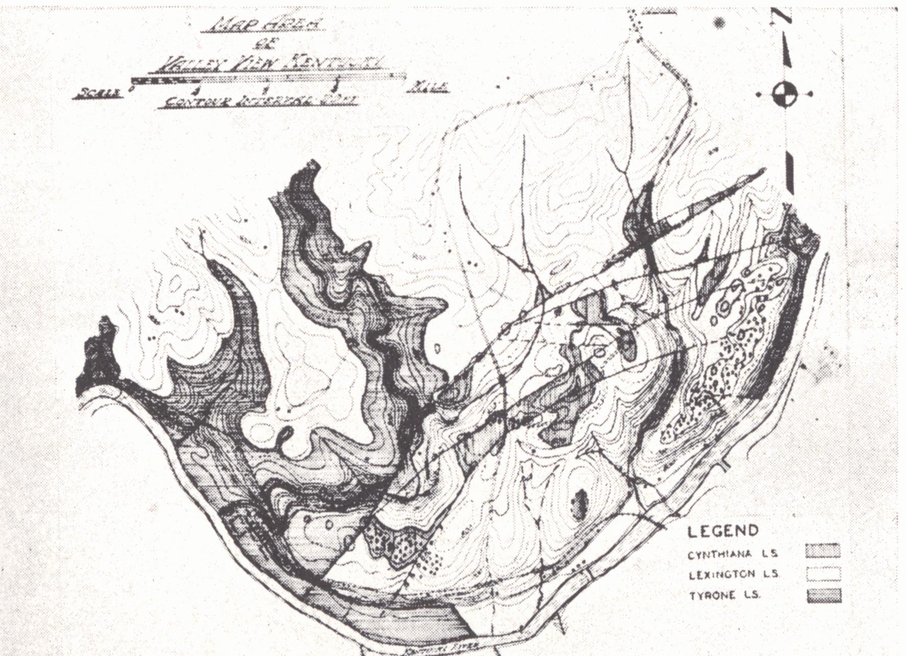 |
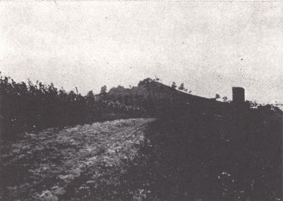
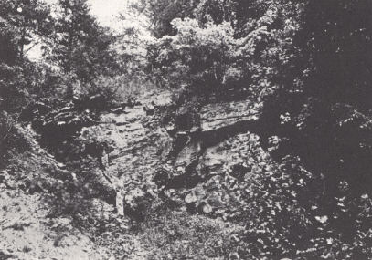
| FIG. 1. Burdett Knob, northern Garrard County. This is an outlying knob 12 to 13 miles north of the Knobs region and Muldraugh's Hill south of Stanford. It is an outlier of the Ohio and Waverly formation downfaulted and preserved in an area of Mid-Ordovician outcrop on the crest of the Jessamine dome. | FIG. 2. Kentucky River fault zone near Valley View in southeastern Jessamine and southwestern Fayette counties. |
 |
 |
| FIG. 3. Irvine fault, locally known as the Glen Cairn fault. The Big Lime (St. Louis-Chester) is faulted down to the level of the Waverly (left-west). | FIG. 4. Graben in Spillman's Branch 1 mile below Kennedy's Bridge, Lake Herrington. The thin-bedded limestone and shale outcropping on the bank is the Jessamine formation faulted down to lake level. Just to the left of the picture the Camp Nelson is at water level. The Tyrone limestone forms the cliff to the right center on the upthrow of the second fault. |
The West Hickman (Lexington-Maysville) Fault Zone is similar to the Kentucky River fault. It is terminated by that fault to the south and extends northward, though mapped with some uncertainty, as a single fault to Maysville. The southern half of the zone is similarly a graben. Through the central Blue Grass it is marked by the preservation of Eden shales, the tight clay soils of which have given rise to the term "Buffalo Trail" and its vegetation to the term "Beech Ridge."
Faulting of the Western Kentucky Fluorspar Region.—The region involved in Caldwell, Crittenden, and Livingston counties and vicinity and extending into Hardin and Pope counties, Illinois, is an intensely faulted one and comprises the fluorspar region of western Kentucky and Illinois. It is 50 to 60 miles in diameter and is notable in the degree of faulting in contrast with other parts of the Interior Low Plateaus. Along with the intense faulting, peridotite dikes and veins of fluorspar occur to constitute the world's greatest fluorspar producing region.
The faults are in the main normal, but there are some associated high angled thrusts. The fault planes are high angled, usually 70 to 85 degrees, with displacements as high as 1300 to 1500 feet. Brecciation of the wall rock gives a fractured zone up to 100 feet wide but the limestone fractures are usually "healed" with calcite. The sandstone breccia remains uncemented, or close to the fissures, the fractures may be completely filled with quartz and to a minor degree with fluorspar (Currier, 1923).
In Crittenden and Livingston counties, Kentucky, and Hardin County, Illinois, the general trend of the main faults is northeast-southwest, but in Caldwell County it swings to east-west. This suggests part of a radial pattern. The main faults are joined by diagonal cross faults breaking the area into an intensely broken fault mosaic.
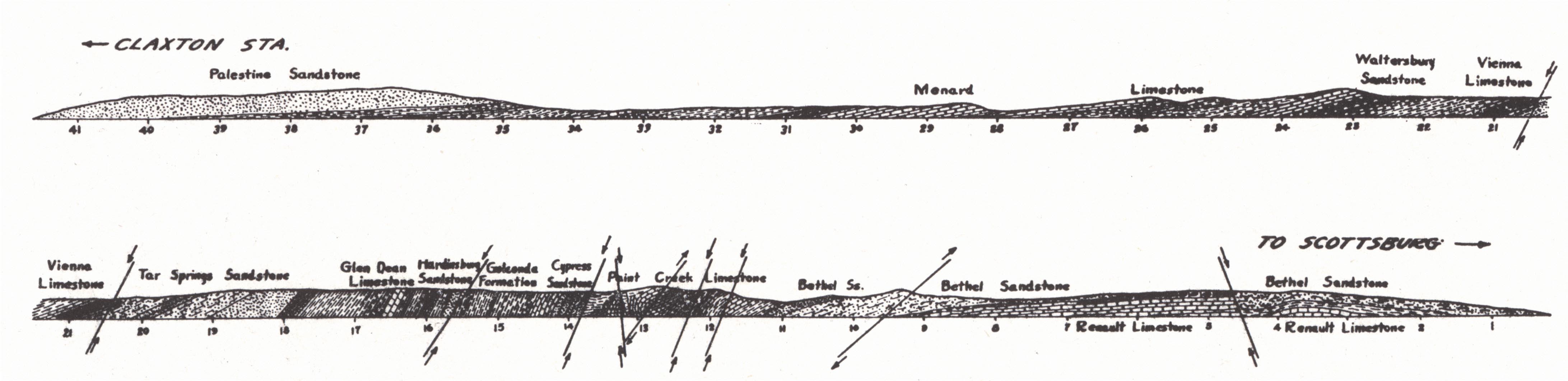 |
| FIG. 16. Structure section, Walche's Cut on
Illinois Central Railroad, Claxton Station vicinity, Caldwell County, Kentucky. Horizontal scale: 1 inch = 300 feet (after Stuart Weller, 1923) |
These faults intersecting Mississippian and Pennsylvanian strata are post-Pennsylvanian in origin. To the southeast the faults terminate in outcrop with the Cretaceous and Tertiary cover of the Mississippi Embayment. It has been regarded likely that the New Madrid earthquake of 1811 and formation of Reelfoot Lake, Tennessee, were caused by renewal of movement alone one of these fractures. To the west of the embayment in Ste. Genevieve County, Missouri, (Weller and St. Clair, 1928) a somewhat similar mosaic along a narrow belt has a northwest-southeast trend. Here two periods of faulting are recognized: (a) late Devonian normal faulting, and (b) late Paleozoic thrust faulting. It has been customary to associate these tension faults with igneous intrusion as a cause.
In a recent paper Rhoads and Mistler (1941) have shown that faulting on a small scale has continued on into the Tertiary. Field evidence included a number of observed faults in these later rocks, local steep dips, sandstone and clay dikes, and local excessive thicknesses of sediment regarded as caused by deposition within sagging blocks of the earth's crust. The very nature of the Purchase sediments precludes the frequent preservation of evidence of such structures in surface outcrop.
Cumberland Arch.—A broad arch is shown on the state geological map with axis in the region "Between the Rivers" near where the Keokuk is overlapped by the Cretaceous and Tertiary of the Gulf Embayment. The same arch is shown on the state structure map with contours drawn on top of the Chattanooga shale. The presence of this arch is open to question, (a) The Mississippian limestone in the western area of outcrop dips to the northeast beneath the Pennsylvanian of the Western Coal Field. This dip is a part of the regional structure bringing the early Paleozoics and Pre-Cambrian to the surface again in the Ozark uplift. The structure is late Paleozoic in origin, though earlier contributing movements are recognized, (b) The Cretaceous and Tertiary of the Purchase have a gentle southwesterly dip taking the older beds beneath the younger toward the axis of the Embayment, a matter of progressive subsidence along this axis. This subsidence superimposes a later westward tilt on the eastward dipping Mississippian and older beds. Whether a reversal of dip was brought about depends on the relative magnitudes of the two movements.
The northeastward dip of the outcropping Mississippian is about 40 feet per mile toward the Western Coal Field. There are not sufficient good well records in the Purchase to determine the position of the tilted erosion surface beveling the Mississippian and none in which the subdivisions of the Cretaceous may be traced. These would give some indication of the amount of down warping toward the axis of the Gulf Embayment. The log of the Roney, Mitchell, and Bruer well 8 miles southwest of Hickman in Fulton County gives a section of Tertiary and Cretaceous (as interpreted) of 2270 feet. A subsidence of this amount would involve a westward tilt of less (±30 feet per mile) than that mentioned for the regional dip of the Mississippian indicated above. There seems to be suggested a terracing of the regional eastward dip of the buried Mississippian on the eastern flank of the Ozark structure rather than reversal.7 West of the axis of the Gulf Embayment there would be, of course, a corresponding steepening of the earlier dip leading to Pre-Cambrian outcrop in the Ozarks.
 |
|
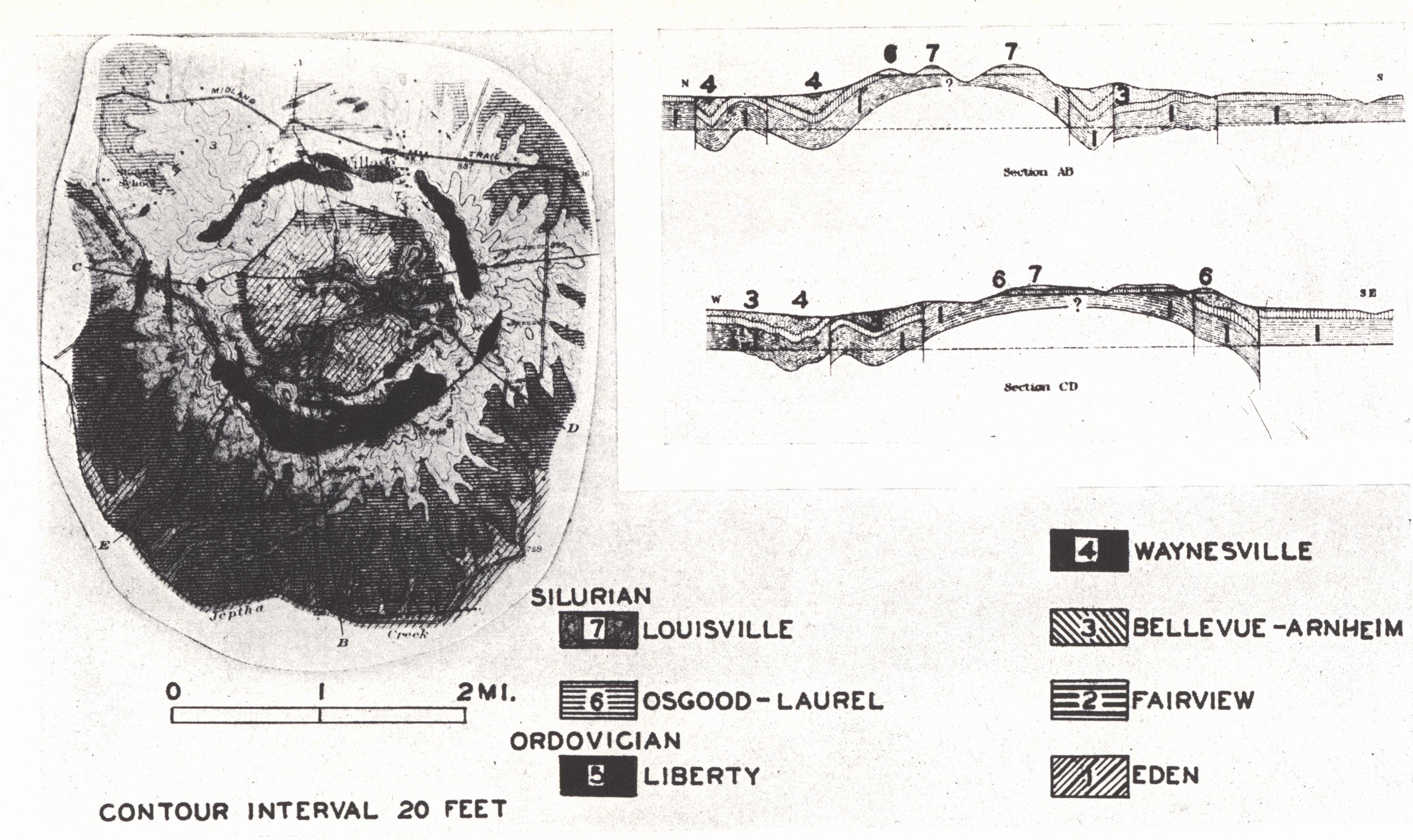
FIG. 17. Jeptha Knob, Shelby County.
Geologic map and structure sections |
Cryptovolcanic Structures.—The term has been applied to a type of structure represented by Jeptha Knob in Shelby County, Kentucky, (Bucher, 1925a) and several others in the adjoining states of Ohio, Indiana, and Tennessee. A characteristic feature held in common by the Jeptha Knob and the Adams County (Serpent Mound), Ohio, structures is:
"They lie in undisturbed plateau sediments, are circular (four and two miles in diameter respectively) and also show a central portion pushed up in irregular blocks above the normal level, surrounded by a ring-shaped, marginal portion within which the rocks dropped to varying depths below it. No trace of heat effects is seen. . . . The writer considers it probable that structures of Serpent Mound type are the result of choked phraetic explosion; that is of explosions at too great depth in proportion to their violence to cause a blasting out of the surface" (Bucher, 1925b, p. 149).
These structures in a region of relatively undisturbed strata, and devoid of igneous phenomena except for the Elliott County and western Kentucky dikes, are significant in their suggestion of deep lying igneous intrusives. The Jeptha Knob structure (Bucher, 1925a) is early Silurian in origin, as indicated by a flat-lying cap of Mid-Silurian. The Adams County (Ohio) structure (Bucher, 1921, 1925b, 1936) involves the Waverly. The Flynn Creek structure (Tennessee) is post-Leipers (Maysville)—pre-Chattanooga (Wilson and Born, 1936) and the Wells Creek structure is post-Meramec. The Howell structure (Tennessee) is interpreted as post-Trenton—pre-Fernvale (Richmond) but the latter beds are also somewhat disturbed apparently by a later renewal of deformation (Born and Wilson, 1939). The Kentland, Indiana, structure (Shrock and Raasch, 1935) involves only Ordovician beds, and no later beds occur in the vicinity. Undisturbed capping beds pre-dating the deformation are present only in the Jeptha Knob, Flynn Creek, and Howell structures. At least three periods of intrusive activity are indicated.
Boon and Albritton (1936) have suggested that these structures were the result of meteorite impact. The original meteorite crater would, of course, have long since disappeared as well as any meteorite material. More recently it has been suggested that Jeptha Knob was an ancient landslide phenomenon (Wheeler, 1938). Field evidence is entirely to the contrary.
Jeptha Knob is an isolated hill in eastern Shelby County just south of Clay Village. It is a couple of miles in diameter and rises to an elevation of 1176 feet, more than 300 feet above the general upland level of the surrounding country—a monadnock rising above the level of the Lexington plain. Structural features and the strata involved are indicated in the accompanying figures. The structure has been drilled for gas without success.
Footnotes
1 The Irvine-Big Sinking field of eastern Kentucky is located on a pre-Ohio
buried anticline. The northeast extension of the Davenport pool (Warren County),
the Green River gas field (Green and Taylor counties), and the LeGrande and
Logsden Valley oil pools (Hart County) are examples of such trend pools.
2 Discussed by the author (1939).
3 The greatest depth of this trough from the end of the Silurian through the
Pottsville, as indicated by maximum combined thickness of these systems, lay
along, or a few miles to the east of, the present Allegheny-Cumberland front.
Along the position of this axis Appalachian type of structure-gives way to the
milder structures of the Plateau, and earlier Paleozoic outcrop is replaced by
that characteristic of the Appalachian Coal Field (Price, 1931). This structural
axis is referred to by that author as a "structural front" in contrast to the "erosional
front" of the Allegheny and Cumberland plateaus.
4 On the other hand a more localized earlier movement is indicated in a
recent and as yet unpublished paper by Lafferty and Thomas (see legend for pl.
CV) who show a "Corniferous" basin centering in Johnson and Martin counties,
thus corresponding with part, but not the deepest part, of the present basin in
Kentucky.
5 Includes her findings since publication of the work in 1941. As a result of
this later work the identification of some stratigraphic units has been changed.
6 Gardner (1915) called attention to a structural disturbance extending from
central Pennsylvania where it is known as the Chestnut Ridge anticline, across
West Virginia and Kentucky into southern Illinois. In Kentucky this structural
line includes the Warfield anticline, the Irvine-Paint Creek uplift, the
Kentucky River fault and the Rough Creek fault.
7 In a recent structural map of central Tennessee contoured on the top of the
Chattanooga shale, Wilson and Born (unpublished manuscript) show a reversal
along a north-south axis in Decatur and Benton counties, Tennessee, and refer to
it as the West Tennessee arch. This is in line with the Cumberland arch of
Kentucky.