EASTERN KENTUCKY MOUNTAINS
The Eastern Kentucky Mountains include that part of the state east of the
westward-facing Pottsville Escarpment. It includes the Cumberland (Allegheny)
Plateau and the Cumberland Mountains, a term recently employed for Pine and
Cumberland mountains and the intervening Middlesboro Basin (Fenneman, 1938). The
western margin from the Tennessee line to Rowan County is a west-facing cuesta.
This is the Pottsville Escarpment. Throughout most of its extent this cuesta is
capped by the resistant eastward dipping Rockcastle conglomerate with a summit
level of about 1400 feet. The Corbin sandstone forms a minor cuesta to the east.
South of Somerset the level rises and near the Tennessee line reaches 1800 feet.
In this region heavy sandstones intervene between the Rockcastle and Corbin, and
the entire Lee section forms the cuesta. Northward the Escarpment breaks down
with the pinching of the Rockcastle conglomerate, and the regional boundary is
replaced by the somewhat less conspicuous Waverly Escarpment, which in Ohio is
the more prominent of the two.
| PLATE XLI |
 |
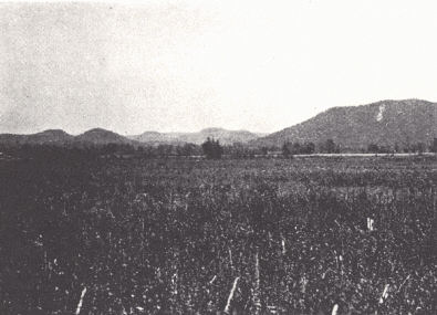 |
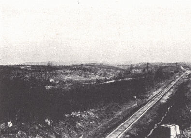
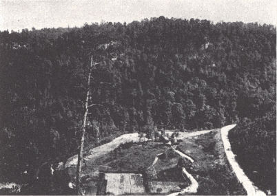
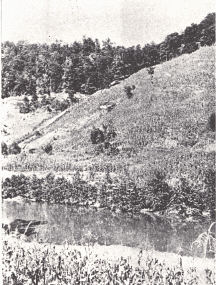
FIG. 1. Pottsville Escarpment
from 10 miles west of Irvine. The hilltop
level of the lowland in the
foreground is that of the Lexington
peneplain. |
FIG. 2. Red River valley in
the vicinity of Stanton, Powell County. The
broad valley floor is developed
in the Ohio and Waverly shales. |
 |
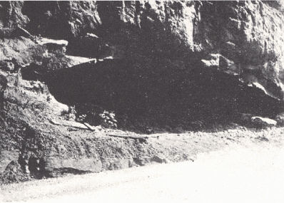 |
FIG. 3. A small cultivated
area looking east from Sky Bridge, northeastern
Powell County in the rugged
western margin of the Eastern Coal Field. |
FIG. 4. A small rock shelter
in the Rockcastle sandstone near Sky Bridge,
northeastern Powell County. The
development of such a shelter on a
narrow divide is the first step in the
forming of one type of natural bridge. |
Cumberland Plateau.—The Cumberland (Allegheny) Plateau is a maturely dissected
plateau of varying altitude and relief and with local variation in character
which is the expression of variation in rock outcrop and character. It is a
region of dendritic drainage with its complementary maze of irregularly winding
narrow-crested ridges and deep narrow valleys. Flat land, either upland or
lowland, is at a minimum, though locally in areas of shale outcrop considerable
bottoms have been developed. Also massive sandstones have given rise to local
upland flats.
The crest of the Waverly Escarpment in the vicinity of the Ohio River is at 1200
to 1300 feet from which the upland level drops off with the dip to the southeast
to about 1,100 feet at the western edge of the area of Pottsville outcrop, and
farther east along the Ohio and Big Sandy rivers to 900 feet. Near Irvine the
crest of the Pottsville Escarpment is at about 1400 feet from which the hilltop
level drops off down the dip to form a lowland area at about 1000+ feet around
Beattyville; similarly, elsewhere (pl. XXXVII). These lowland areas east of the
Pottsville and Waverly escarpments are regarded as eastward extensions of the
Lexington (Harrisburg) peneplain.
South of Jackson County the Escarpment rises above the Pennyroyal instead of the
Blue Grass and attains an altitude of about 1,800 feet in southern Kentucky. The
Pennyroyal surface (stripped plain) slopes southward from 1,300 to 1,400 feet at
Muldraugh’s Hill to about 1,000 feet in southern Kentucky, above which the
Pottsville Escarpment stands ±700 feet higher.
To the southeast of this marginal cuesta there is general increase in hilltop
level, and with it relief, to altitudes of 2000 feet and more, above which Pine
Mountain and others to the east rise. Relief along the western border ranges
from ±700 feet at the north to ±1000 feet near the Tennessee line. At Pikeville
and Barbourville relief is 900 to 1000 feet and ±750 feet respectively.
Davis (1923) recognized and named two sections:
The Ridge Top (and Limestone Valley) Settlements comprise mainly the region of
outcrop of the Rockcastle conglomerate, the region of the westward-facing
Pottsville cuesta with its deeply dissected eastward sloping strip plain.
Streams have trenched themselves in steep-sided and precipitous-walled valleys,
capped with cliffs often several hundred feet high. It is a region of rock
shelters and natural bridges, and toward the east rapids and waterfalls, as the
conglomerate passes from hillside to valley bottom. In the western portion near
the Escarpment divides are narrow but they involve considerable summit area
eastward. Valleys in the western portion tend to be of fair width with
considerable bottom land. Here streams have widened their valleys in the
outcropping Ohio and Waverly shales. To the east as the Mississippian limestones
and the Lee conglomerate come down to stream level, the bottom land disappears
in narrow gorge-like valleys, to widen again eastward as these beds pass below
drainage.
The ridge land is inferior with its thin sandstone soils and rapid erosion. In
the broad stream bottoms of the western edge the extensive alluvial soils are
productive.
The region of the Waverly cuesta in the northern counties is similar but less
rugged.
The area of Creek Bottom Settlements comprises the rest of the coal field to the
east. It is relatively low in its western part with altitudes of 1,100 and 1,200
feet, and near the Ohio River as low as 900 feet. From here, though, there is a
regional increase in altitude, and with it relief and ruggedness of landscape
southeastward to Pine Mountain. Dissection is more mature than in the region of
Rockcastle outcrop. Ridges are almost without flat land except locally where
stripped plains have been formed on some of the more resistant local
cliff-forming sandstones.
The little flat land present is in the bottoms and along the larger streams,
particularly in places where shale dominates. Farms are in the bottoms extending
up every creek and branch and the steep hillsides are actively cultivated. In
Magoffin County along the axis of the Paint Creek Uplift, earlier referred to as
the Conglomerate uplift, the Rockcastle conglomerate locally recurs in outcrop.
Valleys here have the aspect of those in the general region of Rockcastle
outcrop.
| PLATE XLII |
 |
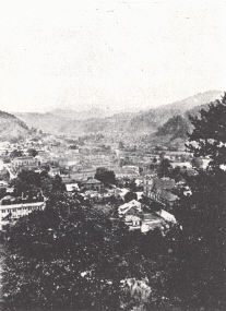 |
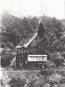
FIG. 1. Coal mine near
Cardinal, Bell
County (Caufield and Shook). |
FIG. 2. Harlan, Kentucky (Caufield
and
Shook). In this region of mature dissection
there is a minimum of flat lowland. |
 |
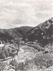 |
FIG. 3. A Leslie County
hillside farm
(Caufield and Shook). |
FIG. 4. Levisa Fork of the Big
Sandy
near Millard, Pike County (Caufield
and Shook). |
Pine Mountain, Cumberland Mountain, and the Middlesboro Basin.— This is the
region referred to by Fenneman (1938) as the Cumberland Mountain Section. Davis
(1921) included it as a part of his area of Creek Bottom Settlements in the
eastern mountains. It is the region of the Pine Mountain overthrust, and its
western and northern boundary in Kentucky is marked by this and the Russell Fork
fault. The Middlesboro Basin, except for greater altitude and corresponding
increase in relief, differs in no essential feature from the plateau region west
of Pine Mountain. Pine and Cumberland mountains are narrow-crested linear ridges
of the Appalachian Ridge-and-Valley type. Pine Mountain is carved out of the
eastward-dipping Lee conglomerate, and a section down to the Chattanooga shale
is exposed. Its crest ranges from 2100 to 2300 feet at the southern end to 2600
to 2800 feet and locally 3000 feet at the north. Cumberland Mountain similarly
has been carved from the westward-dipping Lee on the eastern flank of the
Middlesboro syncline, and on its southeastern face a section from the Lee to the
Silurian is exposed. Its crest approximates 3000 feet over much of its extent
and reaches 3451 at White Rock in southeastern Harlan County. The Middlesboro
Basin with its synclinal structure and very thick Pottsville section includes
some of the best coal land of the Eastern field. Except marginally, the rocks
are flat lying. Within this basin some of the mountains, here of dendritic
pattern, rise to high levels. Big Black Mountain on the state line in Harlan
County (Big Stone Gap sheet), maintained by the Harlan sandstone, rises in "The
Double" to 4150 feet, the highest point in the state. Here the relief exceeds
2500 feet. Log Mountain in Bell County reaches 3200+ feet and local relief is
around 2200 feet. Conspicuous terraces have been developed on the more resistant
sandstones.
The area is drained by the headwaters of the Cumberland River, Poor Fork to the
northeast, and Big Yellow and Clear Fork to the southwest. The river crosses
Pine Mountain in a narrow water gap at a level of 1000 feet in a course that was
presumably established prior to the etching out of Pine Mountain. Cumberland Gap
is well known and is discussed on another page. Pound Gap in Pine Mountain is
also used for a main highway. Russell Fork of the Big Sandy flows around the
end of Pine Mountain in the Breaks of the Sandy, a deep gorge cut in the Lee.
The Eastern Coal Field is only to a limited extent a commercial crop producer,
and the principal crop is corn. Unimproved land1 in 1920 (Davis, 1924)
constituted 65.1 per cent of the total with a county minimum of 27.3 per cent
and a maximum in McCreary County of 89.4 per cent. A minimum is found on the
western edge where production is in the valley bottoms. As long as a large area
of forested land was available, the percentage of improved land increased from
year to year. With decrease in available land a condition of equilibrium was
reached in 1920 (Davis, 1924), with new cleared land just about balancing that
abandoned. The region formerly held an important stand of valuable hardwood
which has by now been pretty well culled over. At least 50 per cent of the land
should be in forest.
Transportation has been a difficult problem. The Kentucky River, and to a
limited extent others, have been made navigable with government dams but are of
declining importance. Because of topography the development of a highway system
has been expensive. The rugged border belt of the Pottsville Escarpment on the
west acted as a barrier to access from the west; similarly, the Pine
Mountain-Cumberland Mountain belt on the east. These were large elements in the
lag in the development of the Eastern Coal Field.
Mineral Resources.—Though not favored agriculturally, the region has been most
productive in mineral resources. Coal is outstanding with its best development
in the southeastern counties. The coal is somewhat superior to that of the
western field and there is more of it. The bulk of Kentucky natural gas
production comes from Floyd, Pike, and Martin counties, and only a small part
from without the eastern field. The group of oil pools of Lee, Estill, and
Powell counties, and again those of the region of the Paint Creek uplift in
Johnson, Magoffin, and Lawrence counties have been noteworthy. The clay industry
has been developed in many places on a small scale, and the Olive Hill fire clay
district is particularly important.
Notes on Physiographic Development (see p. 159).—There exists considerable
uncertainty in regard to the identification and correlation of erosion surfaces
and cycles of erosion in the Appalachian Plateaus and regions to the east.
Attention is called to several points:
(a) The Schooley peneplain, somewhat reduced by subsequent erosion, is commonly
recognized as marked by the crest of the Waverly-Pottsville Escarpment (called
Cumberland Escarpment in Tennessee) on the west. On the east Pine Mountain is
regarded by Fenneman (1938) as most representative and Cumberland Mountain,
which is somewhat higher, as having been only imperfectly peneplained. Allowance
is, of course, made on all of these levels for monadnocks and later lowering. As
such, if the Cumberland Plateau level at ±2000 feet along the Pottsville (Cumberland)
Escarpment in northern Tennessee is correctly interpreted as the Schooley level,
and similarly the crest of the Waverly Escarpment in Ohio, the decline of the
crest of the Pottsville Escarpment northward is a matter of later tilting of
this erosion surface. Similarly, the decline in the crest of Pine Mountain from
3000 feet at its northern end to 2100 feet near the Kentucky-Tennessee line is
to be interpreted in the same manner. This slope suggests a southward tilt
which, in conjunction with the northward tilt of the Pottsville Escarpment,
involves a peculiar twisting of this surface on opposite sides of the plateau.
Both are topographic features carved out of lower Pottsville sandstones and
conglomerates, and to the north the Waverly. Decline of the crest of the
Pottsville cuesta northward is at least to some extent a matter of the less
resistant character and thinning of the Rockcastle conglomerate in this
direction. There is also a great thinning of the Big Lime (St. Louis-Lower
Chester) northward and these beds contribute to the forming of the Escarpment.
With less effective cap to the north there must have been more rapid recession
and lowering.
(b) The lowland belt (pl. XXXVII [Ch. 12]) at the eastern edge of the Pottsville cuesta
has a hilltop elevation of 1100 to 1200 feet. Taking into consideration the
tilt of the Lexington Plain which brings it to a level of 1600 to 1700 feet
(Harrisburg) in the vicinity of Cumberland Gap, these dissected flats are
regarded as the product of that cycle.
(c) The lowland centering around Boyd County is an extension of the Worthington
plain (Butts, 1904) of West Virginia and western Pennsylvania. It has been
regarded as merging with the Lexington plain to the west and thus being its
equivalent. In West Virginia and western Pennsylvania it occurs as straths
along the main streams 100 to 140 feet below the level of the Allegheny
peneplain. Its locally greater development is a matter of the weaker rocks of
the Allegheny series.
(d) The Allegheny peneplain has not been well worked out and correlated, and
the record of this cycle in Kentucky is not known.
 |
 |
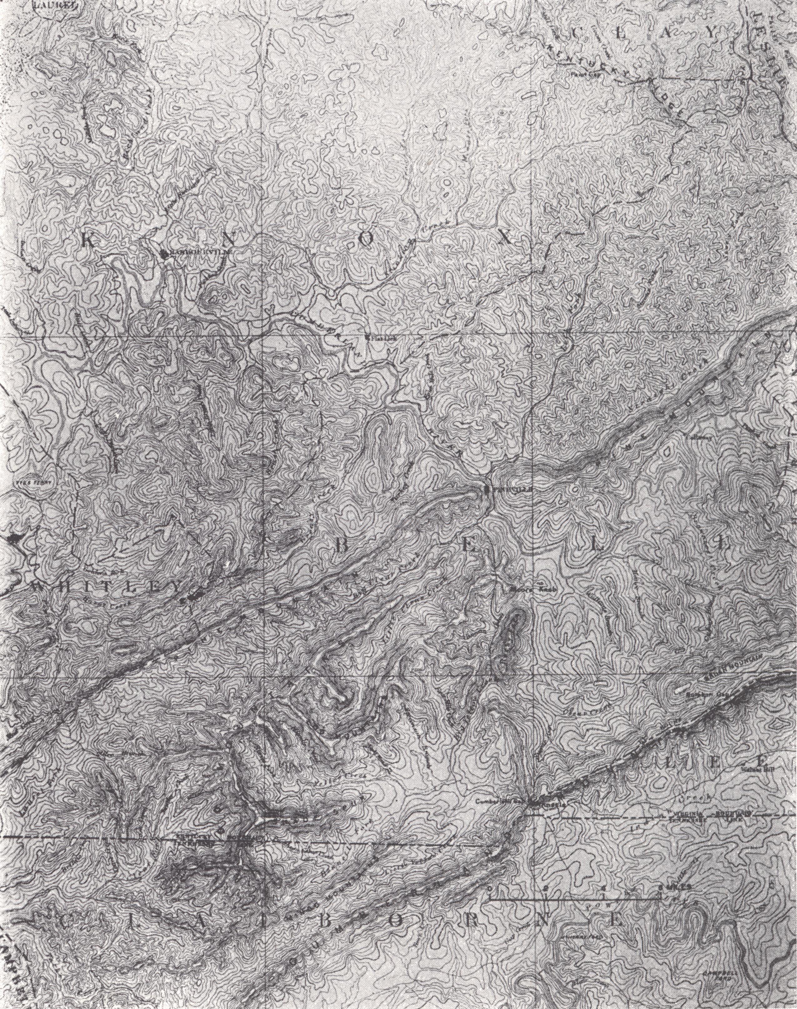
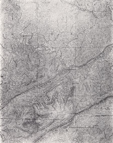
| PLATE XLIII
Cumberland Gap topographic sheet (± x ⅓)
Parts of Knox, Bell, and Whitley counties
Pine Mountain marks the change toward the southeast from the plateau country
with essentially horizontal strata to the folded and thrust faulted
structure and linear ridges of the Appalachians. Pine and Cumberland
mountains are ridges carved out of the Lee conglomerate on the limbs of the
Middlesboro syncline. The whole is a part of the Pine Mountain overthrust,
the trace of which follows the front of Pine Mountain. Cumberland Gap is
discussed on page 216. The Wilderness Trail entered the state at this point. |
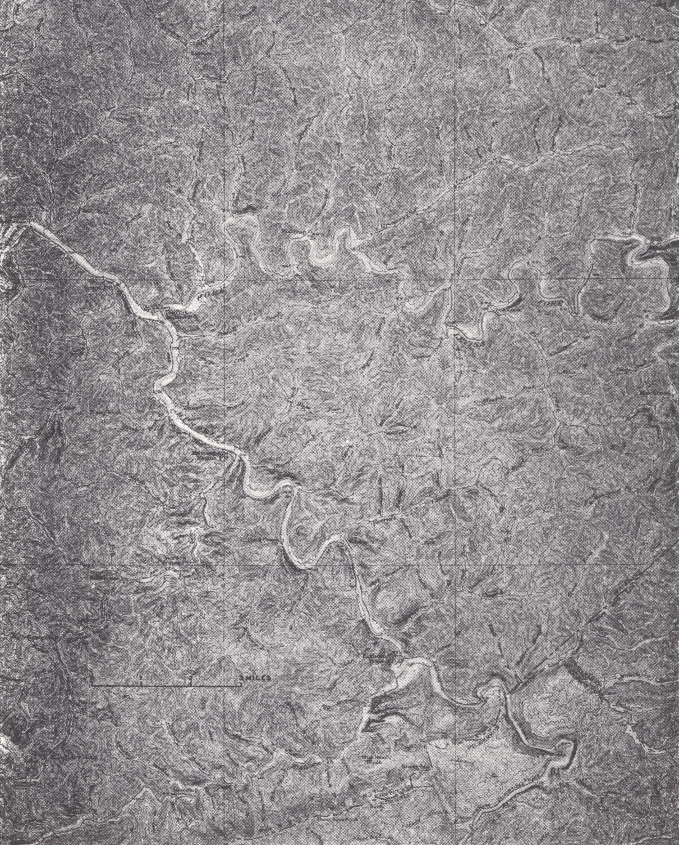
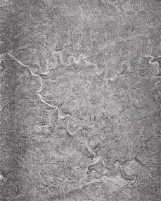
PLATE XLIV Regina
topographic sheet (± X ⅓)
Pike County
A portion of the higher part of the Cumberland Plateau with its maturely
dissected topography. Flat land is at a minimum. Pine Mountain and the
Breaks of the Sandy are shown in the southeast. The trace of the Pine
Mountain overthrust follows the northern edge of Pine Mountain. It turns
southeast as a tear fault (Russell Fork fault), cuts through Skegg Gap, and
then follows Russell Fork for some miles in Virginia. |
Footnote
1 Land of steep slopes and thin soil, some yet to be cleared, and some
abandoned.