KNOBS
The Knobs region in its typical development is a narrow belt of country
surrounding the Blue Grass, characterized by the presence of conical knobs,
which are erosion remnants of the upland behind Muldraugh's Hill on the west and
south, and the Pottsville Escarpment on the east. The region of the dissected
border of these uplands is commonly included in the Knobs until a definite
upland has been attained. In their characteristic development they rise from
the level of the Lexington plain. Similar knob-like erosion remnants, which
front the other escarpments in the state, have not received recognition as
distinct physiographic units. Geologically it is the region of the Ohio-Waverly
outcrop—the shale country between the limestone country of the Blue Grass and
the bordering Pennyroyal and Cumberland Plateaus. Where the
Silurian-Mid-Devonian section is mainly limestone the region is included in the
Blue Grass. Where largely shale, as east of the Arch, it is allied with the
Knobs.
| PLATE XLIX |
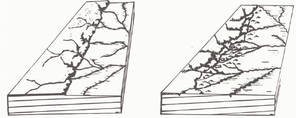 |
| FIGS. 1,2. Diagrams illustrating the
formation of Knobs (Pauline Young).
FIG. 1 (left). Muldraugh's Hill (or Pottsville Escarpment)
with portions of the upland partly
isolated by valley development.
FIG. 2 (right). Knobs in the various stages of development, from flat-topped
portions of
the upland recently isolated from the main area, to typical
conical knobs, earlier isolated
and with the cap rock gone. |
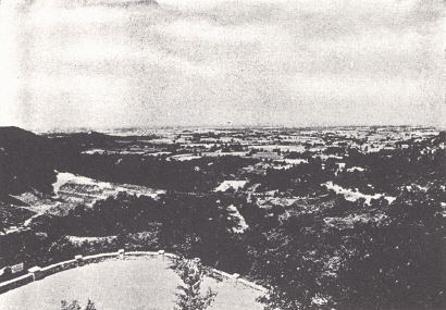 |
FIG. 3. View of the Blue Grass region from
Hall's Gap south of Stanford (Caufield
and Shook).
Hall's Gap is a notch in Muldraugh's Hill and the flat lowland of the Blue
Grass is the Lexington peneplain. |
A number of regional types are recognized :
(a) The border zone of the encircling highlands characterized by its conical
knobs (erosion remnants) which become higher, more numerous, and flat-topped as
the escarpments behind are approached, and rise above the level of the Lexington
plain. This is the typical Knobs country. The Knobs are carved mainly from the
Ohio and Waverly (New Providence-Keokuk) and with the soft shales below is a
region of steep slopes and rapid erosion and soil wash. Near the larger drainage
lines broad shale-floored valleys are developed. Conical forms are normal,
remaining flat-topped only where remnants of the original cap rock are
preserved.
(b) The Lexington peneplain is not coextensive with the outcrop of the
Ordovician and the Blue Grass, but has been extended into the area of Ohio and
Waverly outcrop, particularly along major streams as the Ohio River in Lewis
County. Similarly, it has been extended far into the Mississippian in the
Louisville region. Here, there must be recognized a section of the Knobs whose
summit level is an extension of the Blue Grass level. It is a typical knobs
country, but one in which the hills are erosion remnants of the Lexington plain.
(c) The general area of outcrop of the Louisville and Jeffersonville limestones
is essentially Blue Grass in character (see p. 172). In contrast, in the
eastern area of outcrop the Silurian (Crab Orchard) is largely shale and gives
rise to a country more like that of the Knobs. In essentially this same area
(eastern Clark and Madison counties for example) much of the Richmond is shale,
which gullies rapidly and gives a similar result.
| PLATE L |
 |
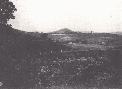 |
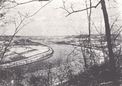
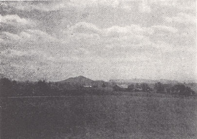
FIG. 1. Looking up (north) the
Ohio River from Alum Rock at Vanceburg,
Lewis County. The plateau level into which the Ohio River valley is
trenched lies just behind (east of) the Waverly Escarpment and is the
upland surface of that cuesta. |
FIG. 2. Knobs
region of Estill County. |
 |
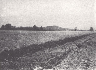 |
FIG. 3. Joe Lick
Knob, 4 miles northeast of Berea with Muldraugh's Hill in
the background. The knob is composed of the Ohio and Waverly shales
preserved in a graben. In origin it is thus much like Burdett Knob (p. 148)
but is much closer to Muldraugh's Hill. |
FIG. 4. Kenwood Hill, a knob a
few miles south of Louisville. It rises
above the Scottsburg lowland to about 750 feet, coming close to the
Lexington peneplain level. The knobs of the usual Knobs region rise
from the Lexington plain level to that of the Pennyroyal and
Cumberland Plateau. |
The Knobs is an area of inferior soil, particularly that derived from the Ohio
(Chattanooga) shale. The steeper slopes of the Knobs and the soft and relatively
impervious character of the bedrock lend themselves to rapid erosion and such
areas under cultivation soon go to pieces. In the flat lowlands the tight clay
soils drain poorly. When drained and fertilized they are productive. The
alluvial bottoms are better, as soils from external sources are mixed with
those of local origin.
 |
|
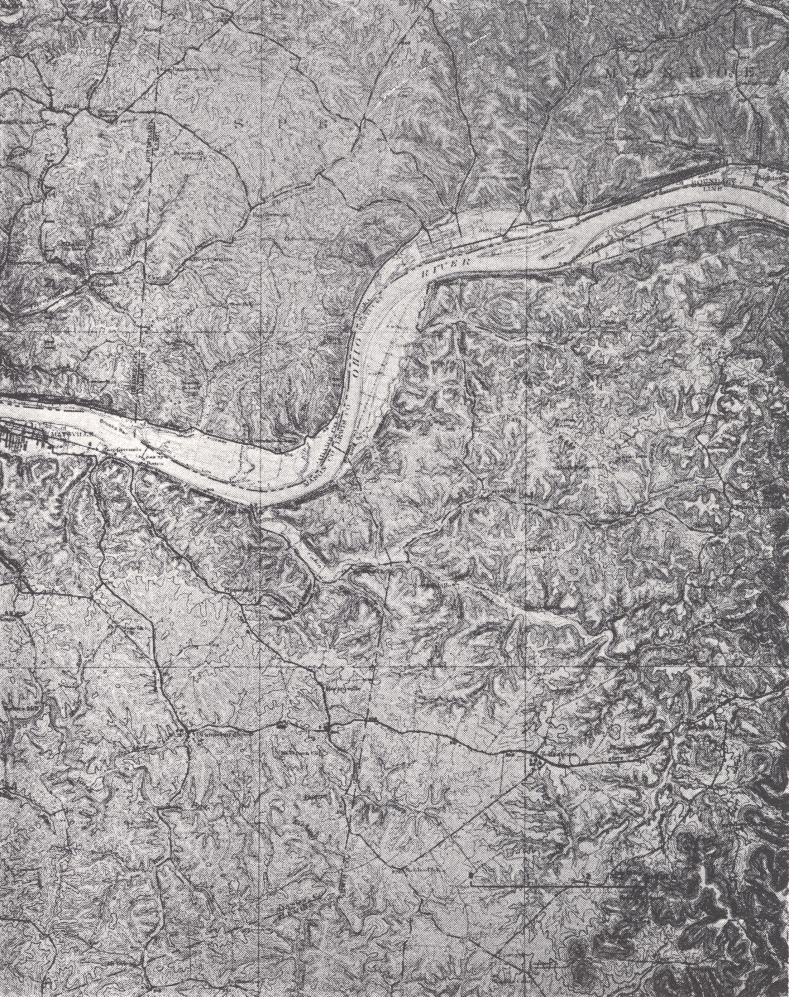
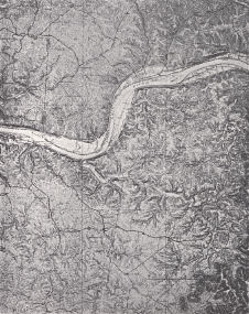
PLATE LI
Springdale topographic sheet (± x ⅓)
Parts of Mason, Fleming, and Lewis
counties
The greatly dissected area of Silurian,
Devonian, and Lower Mississippian
shales contrasts with the more youthful
topography of the southwestern part
developed on Cincinnatian limestones.
This is a "knobs" country with hilltops
rising to the Lexington peneplain level.
The Waverly Escarpment with the
normal development of knobs is
shown along the eastern edge of the
sheet. |
The area thus includes:
(a) An eastern belt in front of the Pottsville Escarpment with its Rockcastle
conglomerate cap, flat-topped while the cap remains, conical after its removal.
(b) The southern and western belt in front of Muldraugh's Hill, where the St.
Louis forms the cap rock. These are similarly flat-topped while the cap rock
lasts.
(c) "Knob" areas lying below the Lexington peneplain level, including some
greatly dissected areas, near the major streams and some relatively flat. South
of Louisville typical knobs, erosion remnants of the Lexington plain, rise above
the Scottsburg lowland.
The width of the belt of Knobs varies. In the Louisville region with gentle dip
and no faulting it covers a broad zone. In the southern Blue Grass with a
bordering fault and steep dip on the southern or downthrow side, the Knobs zone
is very narrow. Within the Blue Grass proper a number of isolated knobs are
found in areas where the Ohio and Waverly formations have been locally preserved
in downfaulted blocks. Such is Burdett Knob in Garrard County, Joe Lick Knob,
Madison County, and a number of other such outliers of Ohio shale, and in places
Waverly.
Although the region is typically one of rough topography, major stream bottoms
are broad and flat. Side-cutting has been rapid in the weak shales and soft
sandstones. The Licking River near Salt Lick is a notable example. Down-cutting
has been retarded by the Mid-Devonian and lower limestones, and an extensive
floodplain has been developed upstream in the shales.
Resources.—Agricultural resources are limited by inferior soil and steep slopes,
and the contrast with the bordering Blue Grass region is great. The tops of
knobs have been successfully used for orchards. Mineral resources are also
limited. Oil shale is a potential resource. The Irvine and associated oil and
gas pools of Lee and Estill counties lie in this marginal zone of the Knobs and
the Cumberland Plateau. Sandstone for building purposes is quarried in Rowan
County. Mineral waters have been important, but are less so now. Clay and shale
are widespread but not widely used. Residual clays along the Ohio River and
other streams are of the same types found in these floodplains in other regions.