NATURAL AND SCENIC FEATURES
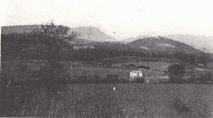
Cumberland Gap.—Cumberland Gap is a notch about 1000 feet deep near the southern
end of the narrow-crested linear Cumberland Mountain where Kentucky, Tennessee,
and Virginia corner. The bottom is at 1650 feet, thus 400 to 650 feet above
drainage (Powell and Cumberland rivers) and about 500 feet above the lowlands of
the Middlesboro Basin. The crest of the mountain just north of the Pinnacle
exceeds 2700 feet.
The Gap is of historic as well as scenic interest for it was the gateway for the
Wilderness Trail through the Cumberland Mountain barrier. This was the most
traveled route into Kentucky by early settlers. As far as written record goes it
was first mentioned by Dr. Thomas Walker, who passed through it April 13, 1750
and referred to it as Cave Gap. He mentioned evidence of earlier whites,
however, and the great Indian Warrior Trail passed through it. Further interest
is found in the Union trenches of Civil War days.
Cumberland Gap is a wind gap which has commonly been regarded as a portion of
the abandoned valley of the headwaters of the Cumberland River which originated
somewhere in North Carolina or vicinity. Thus Hayes and Campbell (1894, p. 103)
reported:
"In the central portion of the province the Cumberland River probably drained a
portion of the Appalachian Valley in southwestern Virginia, holding its
antecedent course through Cumberland Gap and flowing into the extreme end of the
Mississippi embayment.
"Cumberland river had cut deeply into the old Cretaceous peneplain and again
baseleveled its valley in the soft limestones of the plateau region. It also
probably baseleveled a small area of folded rocks in the Appalachian valley—the
present basin of Powell River which then flowed westward through Cumberland Gap"
(p. 108).
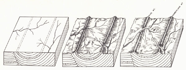
Piracy was favored by the Lee conglomerate forming Cumberland and Pine mountains
through which the Cumberland cut and the headwaters were captured by the Powell
River of Tennessee. Since capture and the abandoning of the gap, erosion has
etched out Cumberland Mountain into still greater relief.
This picture of the situation has been modified by Rich (1933) who out-lined
evidence to show that the gap was formed by an eastward-flowing tributary of the
Powell River (now a part of Yellow Creek), a tributary later captured by the
Cumberland. Difficulty of a creek in gnawing its way through the Lee
conglomerate of Cumberland Mountain in contrast to the same work by the
Cumberland River at Pineville created conditions leading to the capture. Rich
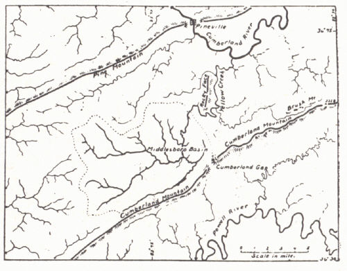
pointed out the very suggestive stream pattern of the Middlesboro Basin (p. 217)
and that elsewhere drainage across Cumberland Mountain (ex-Pennington and Big
Creek gaps) was eastward. The lower ridge crest southwest of the gap he
explained by the steeper dip of the Lee conglomerate, hence narrower belt of
outcrop and more rapid erosion.
The correspondence in elevation of Cumberland Gap to the ridge levels assigned
to the Harrisburg peneplain east of the Gap suggests the date of capture. The
northwestward tilt of the Harrisburg plain in late Tertiary, a tilt contrary to
the direction of flow of the stream, facilitated capture and diversion to the
Cumberland drainage of the present headwaters of Yellow Creek.
It has long been recognized that a weak zone in Cumberland Mountain existed at
the Gap because of crushing in the Rocky Face fault movement. A gap would likely
develop under these conditions without a former through stream. The stream
pattern of Yellow Creek referred to above, however, is strong evidence of
piracy.
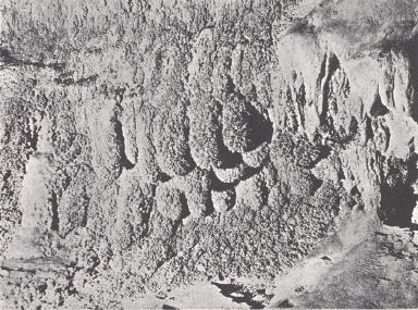
| PLATE LX |
 |
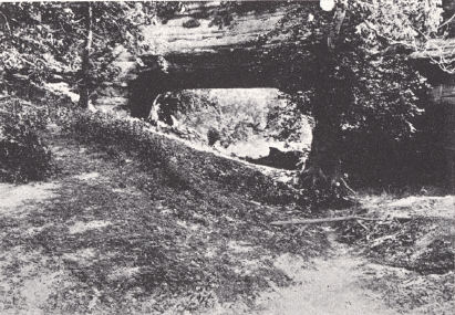 |
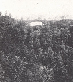
FIG. 1. Natural
Bridge of Kentucky at the state park near Slade in Powell
County, viewed from the east. It was formed by the development and
growth of a rock shelter in the Rockcastle conglomerate along a
narrow cliff-bordered divide. The breaking through of the rock shelter
(forming a light house) was facilitated by a landslide cutting off a part
of the divide. A portion of the cliff which moved only a foot or so
constitutes the "fat man's misery" |
FIG.
2. Creelsboro Natural Bridge near Creelsboro, Russell County, an upper
Ordovician limestone span. It has been regarded as the perforated meander
type but solution had already opened up small cave passages in the
limestone which were ultimately exposed on the surface as the divide was
narrowed by stream undercutting on each side. |
 |
 |
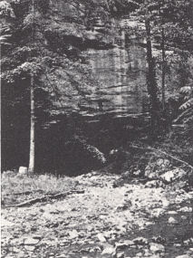 |
FIG. 3. Sky Bridge in
northeastern Powell
County, 4 miles northwest of the state park. |
FIG. 4. Smoky
Bridge on Smoky Fork of
Tygarts Creek near the Carter Caves,
Carter County.
It is a Ste. Genevieve-
Chester (Big Lime) limestone span of
the "Natural
Bridge of Virginia" type.
The receding rapids is a couple of
hundred feet
upstream. |
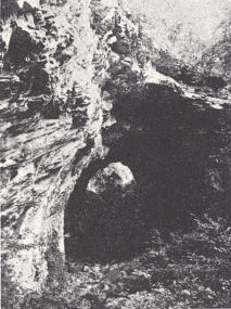
FIG. 5. A stream entering the
Mississippian limestone cliffs at a level
below that of "X" Cave of the
Carter
Caves group. Upstream a quarter of a
mile it passes beneath a bridge
representing the former roof of a
cavern and farther up the stream
appears
as a surface stream coming
from the mouth of Bat Cave. |
NATURAL BRIDGES.—The best known natural bridge is that near Slade in Powell
County which is commonly referred to as the Natural Bridge of Kentucky. It is
typical of those formed in the Rockcastle sandstone and conglomerate belt of the
western margin of the Eastern Coal Field and in similar regions. Here the
conglomerate caps the divides in a thoroughly dissected, rugged country of
about 600 feet relief and hilltop level at 1200 to 1300 feet. The upland level
is controlled by this cap rock and the underlying Chester and Meramec limestone.
Valleys are carved in the Waverly sandstones and shales below, and undercutting
in these weaker beds has resulted in the termination of valley sides in vertical
sandstone cliffs.
The region is one of rock shelters (rock houses), which are present by the
thousands and in all sizes and constitute the first step in bridge forming. They
are the result of more effective weathering on locally weaker zones of sandstone
(differential weathering). This involves weaker layers and weaker parts within
the same layer. The locally weaker character of the rock is due to a variety of
things, including degree of induration, thickness of bedding, orientation of the
cross-bedding to the cliff face, intersection of joint planes, etc.
Weathering processes include spalling from temperature changes, wedge work of
ice and vegetation, and solution. The irregularly honeycombed surfaces of the
cliffs are indication themselves of the irregular cementation and resulting
irregular breaking down of the sandstone by solution. Loose blocks, often the
size of a small mountain cabin, are found on the hill slopes. Once a shelter is
begun it is enlarged through a continuation of the same processes, and the
stronger layers are undermined by the weathering away of the weaker. Large
amphitheatre-like shelters are common at the heads of valleys.
Given an exceptionally narrow cliff-bordered divide, the growth of one shelter
pr a pair on opposite sides of the divide results in a break or "light-house"
and the span of rock above constitutes the bridge. Exceptional narrowness is an
essential feature of the divide as is also the more resistant character of the
upper layers of the cap rock; otherwise a gap rather than lighthouse develops.
The Natural Bridge of Kentucky is located on a narrow divide at a point where it
is exceptionally narrow because of the head ward growth of two valleys. In this
case the growth of only one shelter is involved. The south side of the cliff is
broken off clean along a master joint, which contributed to the exceptional
narrowness at this point. It is quite possible that the original opening through
the divide was completed by this landslide. A remnant which has slipped only a
foot or so gives the "fat man's misery" traversed in ascending to the top of the
arch. The opening is 78 feet in length and 65 feet in height; the width of the
span 26 feet at its narrowest point.
A bridge similar in origin and geological set-up is located 5 to 6 miles in an
air line northeast of the State Park bridge (pl. LX, fig. 3) on the divide
between Swift Camp and Parched Corn creeks overlooking the Red River. It has
been known as the Lighthouse Bridge, but was recently named Sky Bridge. It is a
beautiful bridge, gracefully arched, with an additional small isolated "light
house” at one end. Including the small opening the total length is 90 feet,
height of opening 25 feet, thickness of span 5 feet, and width 15 feet. This
arch is now accessible by way of the highway from Slade to Campton and turning
off at Pine Ridge over a ridge road constructed by the Civilian Conservation
Corps. It terminates on the ridge top within 100 yards of the bridge. It may
also be seen to advantage from a continuation of the road below.
Across Parched Corn Creek there is a small lighthouse. From its configuration
it seems to have been formed from the growth of only a single shelter. It is
near the end of a cliff-bordered spur. A well-developed bridge of the same type
is situated about a mile and a half west of the park, again on the end of a
spur. It can be reached by trail from Slade. A couple of others, which the
author has not seen, are shown in the vicinity on the county geological map.
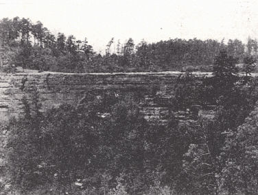
The McCreary County Bridge (pl. LIX, fig. 6) is an outstanding bridge of this
same type. It is found south of Burnside a short distance to the west of where
Ky. Highway 90 to Cumberland Fall joins U. S. Highway 27 and about 9 miles in an
airline from the falls. It is approached from above and occurs near the end of a
long sandstone-capped spur. The opening below is about 50 feet high. The north
side forms a large overhanging shelter. The span above shows remarkably
well-developed foreset beds in the cross-lamination. A sandstone span is also
known near Stearns (McCreary County), but the author has not seen it.
Two large bridges are known in the vicinity of the Carter Caves, Carter County.
They are limestone spans of large size formed in the Ste. Genevieve and Chester,
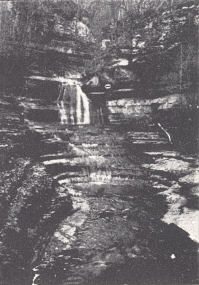
thus in the upper part of the well-known limestone succession of the Mammoth
Cave region. One of them, about a half-mile west of the cave office and known as
the Smoky Bridge (pl. LX, fig. 4) (from Smoky Fork of Tygarts Creek), is of the
"Natural Bridge of Virginia" type.1 The receding waterfalls, or rather a
cascade, is still present 100 yards upstream. The span is 50 feet above creek
level and the opening 50 feet wide and 200 feet long. The initial diversion of
the stream behind the waterfall may well have been facilitated by an
already-existing passage or cavern dissolved in the limestone. This was tapped
in the normal process of valley deepening and recession of the falls.
The bridge in the immediate vicinity of the Caves office is of similar size but
the tunnel bends in the middle so that the opening is not visible from one end
to the other. Fifty yards upstream the creek emerges from Bat Cave, circles
around a wide meander in which cross-bedded limestone is well shown, passes
beneath the bridge, and in another 50 yards downstream enters a lower level of
"X" Cave (pl. LX, fig. 5). It emerges again on the opposite side of the hill as
Cave Branch, a tributary of Tygarts Creek. This bridge (Carter Caves Bridge), is
of the type originating as a subterranean passage and stream in which the stream
has become a part of the surface drainage through collapse of the roof. A
remnant of the roof forms the natural span.
A short distance downstream from the caves and southwest of the road is a "fern
bridge." This term is used for a sandstone (Pottsville) span of the Natural
Bridge of Kentucky type. The sandstone supports a growth of ferns and is thus
locally referred to as "fern rock.” Though typical of its kind, it is not a
well-defined bridge. A large rock shelter has developed in a sandstone cliff low
on the hill. It opens at the rear only in a wide open joint which separates it
from the main body of the cliff.
The sandstone bridge2 (Pottsville) near the mouth of Swift Camp Creek, Wolfe
County, Kentucky spans the cut-off of a former wide meander of this creek. It is
of the type defined by Cleland (1910, p. 314) as formed "by the perforation of
the neck of an incised meander."
The Creelsboro Bridge (pl. LX, fig. 2) is a limestone span near Creelsboro along
the Cumberland River. The bridge is formed of a massive siliceous grey limestone
questionably referred to the Maysville. The narrowness of the divide was
accomplished by under cutting by both Jims Creek and the Cumberland River.
Weathering has kept pace and there is no overhanging cliff. The incipient
opening seems to have been caused by seepage from Jims Creek to the Cumberland
by way of available joints and bedding (Scott and Belknap, 1926). The opening of
a solution passage may have been already accomplished by general underground
drainage before valley deepening had reached the level of the opening and was
later tapped by valley deepening and the narrowing of the divide by lateral
planation.
The height of the opening is 15 feet on the north side and 40 feet, on the
south, the span 75 feet in length, and the length of the tunnel 100 feet. During
highwater of the Cumberland River water flows through the opening to rejoin the
river farther downstream. At times when Jims Creek is in flood and the
Cumberland relatively low the reverse takes place.
| PLATE LXI |
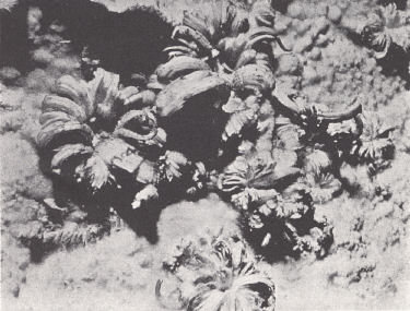 |
FIG. 1. Gypsum rosettes,
Mammoth Cave. Extensive deposits occur
in the drier parts of the cave (Caufield and Shook). |
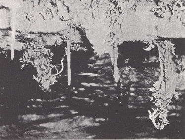 |
FIG. 2. Helictites, Mammoth
Cave. These odd formations are formed
only where the seepage of water is slow (Caufield and Shook). |
LIMESTONE CAVES.—There are two great limestone regions in the state:
(a) that of the St. Louis, Ste. Genevieve, and Lower Chester outcrop, and
(b) that of the Mid-Ordovician outcrop of the Inner Blue Grass in central
Kentucky involving the High Bridge and Lexington limestones. That part of the
Mississippian limestone area centering around Cave City and commonly referred to
as the Mammoth Cave region is best known and famous as one of the world's great
cave regions.
The Mammoth Cave area involves two physiographic regions, both upland plateaus:
a lower, the Pennyroyal, and an upper, the Mammoth Cave Plateau. Almost all
commercial caves are located in the latter section behind the Dripping Springs
Escarpment. Mammoth Onyx Cave is found in an outlying knob of this upland.
Although underground passages underlie the Pennyroyal, as indicated by
innumerable sinks, not many of these have been of commercial size and beauty. In
the eastern area of outcrop in Carter County the Carter Caves and Cascade Caves,
and again others in the Cumberland River region of Wayne and McCreary counties,
have been developed in stratigraphically about the same rocks. In the central
Blue Grass a number of caves are known in the Lexington and High Bridge
limestones. They have been commercialized on a small scale.
The general process of cave forming is well understood, involving the processes
of solution, normal stream erosion underground, and "sapping" (roof collapse).
There is some question, though, as to the relative importance of these
processes in different caves, the position with respect to water table involved
in some of the work, and why the change from destructive processes to those of
"replenishment." These have been rather exhaustively studied by Davis (1930) who
proposed for consideration the "two cycle" theory as contrasted with the more
generally conceived and accepted "one cycle" theory. The one cycle theory
involved the conception that limestone caverns originated by solutional and
corrosional activities of subsurface water above the water table (vadose water).
The two cycle concept holds that caverns are produced largely by ground water
solution below the water table (phreatic water). With elevation of the limestone
above the water table, resulting in the draining of the water which has filled
the cavern during excavation, the deposition of dripstone begins. The sinking
(relative) of the water table resulting from regional elevation or progressive
trenching of surface streams divides the cave history into two epochs. The
theory admits the work of both solution and corrosion above the water table but
relegates such work to a subordinate role.
| PLATE LXII |
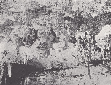 |
FIG. 1. Hanging Gardens (helictites)
in Great Onyx Cave (Caufield and
Shook). |
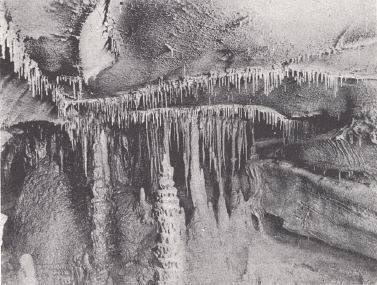 |
FIG. 1. Hanging Gardens (helictites)
in Great Onyx Cave (Caufield and
Shook). |
The Mammoth Cave region is located, as indicated earlier, in the Mammoth Cave
Plateau west of Cave City in Edmonson, Hart, and Barren counties just off the
southeast corner of the Western Coal Field. The earliest record of Mammoth Cave
is found in a deed dated 1797 on file in the records of Warren County at Bowling
Green. Of historic interest is the former use of cave soils, rich in nitrate,
for the manufacture of gunpowder in the War of 1812. A similar use of cave
soils was made in some caves of the Southern States in the Civil War. Included
in the region is a considerable list of commercialized caverns—Mammoth Cave, New
Entrance to Mammoth Cave, Great Onyx Cave, Mammoth Onyx Cave, Floyd Collins
Crystal Cave, Colossal Cavern, Hidden River Cave, Salts Cave, Diamond Cavern,
and others.
The region is bordered by the Dripping Springs Escarpment on the south and east,
and by the valley of the Green River on the north. This includes all of the
larger and most of the caves. They thus lie up the dip from Green River Valley.
Mammoth Onyx Cave occupies a knob constituting an erosional remnant of the
Mammoth Cave upland. Hidden River Cave underlies the western edge of the
adjoining Pennyroyal. The caverns occur in what Miller has designated the
Mammoth Cave limestone, a comprehensive term including the St. Louis, Ste.
Genevieve, and Renault-Paint Creek (Lower Chester) limestones. The Cypress
sandstone is often the roof rock of the entrance and upper passages, as in
Mammoth Cave and Crystal Cave. There is general elongation down the dip.
Mammoth Cave, according to Hovey (1912), has important galleries at five
different levels. These along with intermediate levels are described by Lobeck
(1928, 1929), who gives a vertical variation of about 40 feet for any one level.
They follow the bedding. Narrow passages are controlled by joints and local
passages of exceptional height (or depth) constitute the "pits'' or "domes,"
depending on the location of the observer. Their location in many places has
been determined by the intersection of prominent joint planes.
To these various erosional features names without number have been given;
similarly, for the great variety of dripstone formations. Particular attention
should be called to the helictites, a variety of stalactite of exceptional
beauty varying from the usual form by the upturning of the lower end or
irregular upturning and branching (pl. LXI, fig. 2, and pl. LXII, fig. 1). They
occupy the drier portions of a cave where seepage is slow. They are by no means
common and are valued highly.*
Another unusual deposit is the gypsum found coating walls and ceiling in the dry
parts of some of the caves. It does not occur where there is active dripping or
where the rocks are damp, or if present it is in the process of being dissolved
and removed. It occurs in crusts up to several inches thick, white when fresh,
some with ball-like protuberances, and some with rosettes up to 6 inches or more
across, and clusters of feathers. These are mentioned in order of growth as the
ball-like protuberances burst to form rosettes which in turn grow into the
clusters of flowers or feathers—a progressive development, in appearance not
unlike that of the bursting of a bud into full flower. The growth of these
gypsum forms is strikingly suggested by the growth of ice crystals in loose
soil. The growth is at the base of the crystal instead of the tip as in the
stalactite. Crusts of coarse selenite crystals are also known.
| PLATE LXIII |
 |
| FIG. 1. The sponges on Coral
Walk, Mammoth Onyx Cave. |
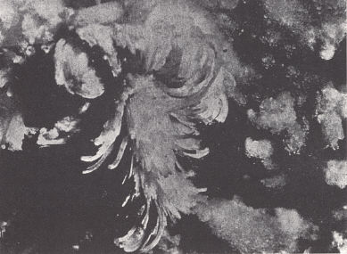 |
FIG. 2. The Alabaster Lily,
Floyd Collins Crystal Cave. A more advanced
stage in the development of a gypsum flower than in plate LXI, figure 1. |
Marcasite is commonly regarded as the source in which the sulphide oxidizes to
form sulphuric acid, which in turn reacts with the limestone. It occurs in the
limestone but more abundantly in the dark shales and impure coal in the Cypress
sandstone.
Fine-grained onyx suitable for polishing occurs and is used for trinkets of
various kinds. The black (dark brown) variety is particularly prized.
The origin of some features deserves further mention. J. M. Weller (1927) has
explained the several levels of Mammoth Cave in terms of repeated regional
uplift. This would necessitate a recurrence of these levels in other major caves
of the region. Davis (1930) pointed out that it is remarkable that if this is
true no such coincidence has been noted to date. Admitting that regional uplift
would have such an effect, the author regards stratigraphic control as the main
factor and is particularly impressed with a recent contribution of Gardner
(1935). The latter calls attention to the porous salt water (connate) zones in
this limestone succession encountered in drilling for oil. Surface valley
cutting creates an outlet draining the salt water down the dip and initiates the
active circulation of meteoric waters and cave forming. The successive
cave-forming levels correspond to the original porous, often salt water-bearing
zones. Cave-forming would be concentrated in the region up dip from the major
valleys, in this case Green River Valley; and the distribution of caves in the
Mammoth Cave region is in keeping with this principle. With progressive
deepening of the Green River valley successively lower zones drained the higher
ones by way of channels developed along joint systems. Changes in the processes
which have operated in any one passage involve change in amount of rainfall,
changes in regional elevation (both up and down), increasing depth of valley
cutting, and shift in water table with these.
Among other difficulties with the one cycle theory Davis (1930) called attention
to the extensive "pits" and "domes" in Mammoth Cave, some extending essentially
from hilltop to the level of drainage. Particularly difficult to explain is the
increase in diameter of some downward. Does Echo River, a tributary of and at
grade with Green River, represent a continuation of the work responsible for the
higher galleries, or is it possible that there are lower water-filled and
forming passages (two cycle theory)?
| PLATE LXIV |
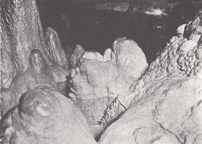 |
FIG. 1. Blind fish in the
Fountain of Youth, Mammoth Onyx Cave. The
pool of water occupies a depression in a mass of stalagmites, hollowed
out by the rapid dripping from the ceiling above. |
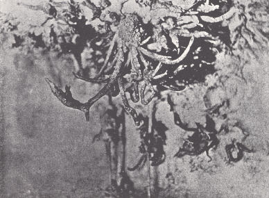 |
FIG. 2. Spider Helictite,
Floyd Collins Crystal Cave. The helictite gallery
in this cave is approached through a long passage opened up by
Floyd Collins with wheelbarrow and shovel. The original passage
had been filled with soil and rock debris washed in. |
Carter and Cascade caverns in Carter County are the best of eastern Kentucky and
are developed in the same limestone formations as those of the Mammoth Cave
region—a much thinner limestone succession, however. The St. Louis limestone is
quite thin this far north. Beneath are the sandstones of the Logan. The caves
occur in the maturely dissected plateau country of the western edge of the
Eastern Coal Field along the waters of a branch of Tygarts Creek. As in the case
of Mammoth Cave, soils from the Carter Caves were used for the manufacture of
saltpeter in the War of 1812. Two great natural bridges of limestone are a part
of the scenic features present.
In the vicinity of the Cumberland River around Burnside a number of caves have
been commercialized on a small scale. They occur in the same limestone as those
above. Again proximity to deep-cut valleys is significant.
The Ordovician area of central Kentucky is a limestone region. Some caves are
known and several have been commercialized on a small scale. Some occur in the
High Bridge limestone, and are found opening in the cliffs of the Kentucky River
and its tributaries. A number of these are known as Boone's Cave in which that
pioneer is supposed to have hidden from the Indians. These include caves near
Camp Nelson, Valley View, High Bridge, and another about 4 miles up the Dix
River. Caves are also developed in the Lexington limestone; in one case with a
stream emerging from it (Russell Cave) and occasionally with streams flowing
into the caves (sinking creeks).
In general the caves of the Blue Grass region are not rich in dripstone
deposits, nor of great size. The reason for their rather meager development is a
matter of lithology, since conditions are otherwise favorable in the Kentucky
River vicinity. The Lexington limestone does not involve any great thickness of
pure limestone without shale. In the case of the High Bridge strata it is likely
a matter of more limited original porosity.
Some archaeological remains and Pleistocene fossils have been found in some of
the limestone caverns of the state. These are described in various publications
on Kentucky archaeology.
*In a recent study of helictites L. C. Huff (Jour. Geology, vol. 48, pp.
641-659, 1940) emphasized hydrostatic head in explaining the upward growth. G.
P. Merrill (Proc. U.S. National Museum, vol. XVII, pp. 77-81, 1894) stressed
capillarity. The importance of the latter is indicated in some wall deposits and
in helictitic growths on some associated stalagmites. Slow seepage is
fundamental and would seem to involve surface seepage as well as that through a
tube.
| PLATE LXV |
 |
 |
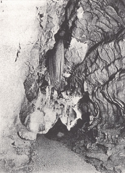
FIG. 2. Entrance
of Hidden River Cave at Horse Cave by way of a large
limestone sink. |
 |
 |
| FIG. 1. Mammoth
Stalactite, Diamond Caverns (Caufield and Shook). |
FIG. 3. The Cat, Mammoth Cave.
A
stalagmite with growth stopped by the
breaking off of the feeding stalactite above.
The ears are two small stalagmites built by
dripping from two new stalactites. |
FIG. 4. Martha Washington's
Statue. The walls of the irregular passage almost close on themselves ahead.
Light coming through the small visible opening constitutes the statue. |
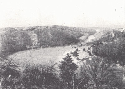
KENTUCKY RIVER GORGE.—The Kentucky River Gorge is a scenic spot of the Blue
Grass region. It is crossed by four main highways—at Clay's Ferry, Camp Nelson,
Brooklyn Bridge, and Tyrone—and by the Southern Railroad at High Bridge, and
Young's High Bridge at Tyrone. The topography is rugged and characterized by
massive limestone cliffs. Tributaries are similarly deep cliff-bound gashes in
the upland and the whole immediate vicinity of the river is rugged and
picturesque.
| PLATE LXVI |
 |
FIG. 1. High Bridge, Kentucky
(Fairchild Aerial Surveys).
The River cliffs are carved out of the High Bridge limestone and the rock
quarry to the right of center is the Tyrone. One of the best developments
of the bentonite layer of the upper Tyrone is in this vicinity. The mouth
of Dix River is shown. A few miles upstream is Dix Dam. |
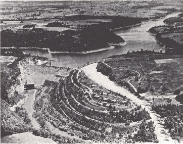 |
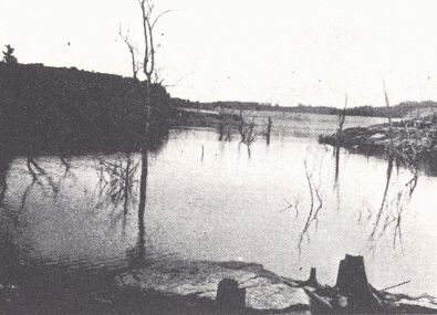
FIG. 2. Dix Dam and Lake
Herrington, Mercer and Garrard counties
(Aero-Graphic Corporation). |
The gorge is restricted to the outcrop of High Bridge rocks. From Boonesboro to
Camp Nelson the river follows the general trend of the Kentucky River fault and
in its broad meanders crosses the fault zone nine times. Where cutting in the
High Bridge on the upthrow to the northwest, a gorge has been developed, where
in the more easily eroded rocks of the Trenton and Cincinnatian on the downthrow,
the gorge gives way to more gently sloped and wooded valley sides and well
developed bottom lands. Both upstream and downstream from the region of the
gorge a broad open valley with extensive floodplain is developed in the younger
and weaker rocks until in the vicinity of Irvine and Beattyville the outcropping
Mississippian limestones and Rockcastle conglomerate again constrict the valley.
A unique feature in some of the tributary creeks is the "petrified
waterfalls"
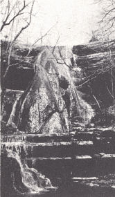
The best known of these is Elk Lick Falls about 10 miles southeast of Lexington
and half a mile west of the Richmond Road. A deposit of travertine has been
formed over the face of a falls 60 feet high. The falls is capped with Tyrone
and is undercut in the badly jointed and more porous Oregon limestone below. The
falls itself and gorge below is not easy to visualize in terms of the rather
trifling stream now occupying the valley. Weathering of the limestone face
behind the travertine deposit has left it partly suspended and it now shows
evidence of progressive destruction. The cause of original precipitation of
calcium carbonate has been variously ascribed to loss of carbon dioxide, either
by agitation of the water or by the effect of mosses and lichens over which the
water trickles, and by evaporation, possibly involving an earlier drier climate.
If the latter be given some credence it should be associated with the earlier
suggestion of a still earlier and more humid climate necessary for the forming
of the falls and gorge. Other smaller examples are known in the creeks of the
same vicinity.
The Kentucky and its main tributaries follow wide meanders trenched in the
upland level of the Lexington plain (800 to 1000 feet). The intermediate valley
(terrace), a couple of hundred feet lower with its alluvial deposits of the
Irvine formation, has been described on p. 125. The meanders are entrenched and
inherited from the cycle which terminated in the forming of the Lexington
peneplain, though the slip-off slope on the inside of many of these curves shows
their progressive development as the valley was trenched; thus both inherited
and ingrown (Rich, 1914). Some of these loops have almost closed on themselves
as in the case of Frying Pan Bend on Dix River and the loop just east of Handy's
Bend on the Kentucky River (Harrodsburg quadrangle).
The gorge of the Dix River has been developed for power purposes with the
building of the Dix Dam 3 miles above its mouth. This was the largest
rock-filled dam east of the Mississippi River—1030 feet long, 275 feet high, and
750 feet thick at the base. Lake Herrington formed behind it has an extent of
about 3000 acres and the lake level commonly ranges from 680 to 750 feet above
sea level. The power plant has a generating capacity of 30,000 horsepower.
| PLATE LXVII |
 |
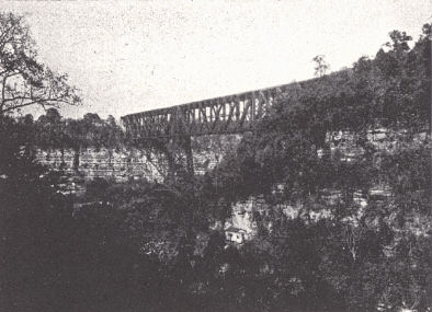 |
FIG. 2. High Bridge, Kentucky.
View from Shakertown-High Bridge road,
showing the rugged river country in the region of High Bridge outcrop. |
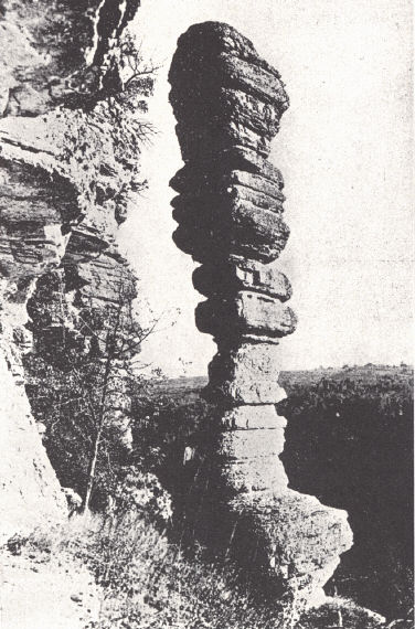
 |
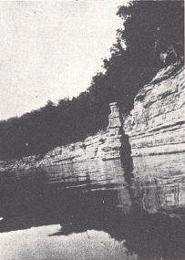
FIG. 1. Chimney
(Candle Stick) rock, Kentucky River cliffs, 2 miles
below Camp Nelson (Caufield and Shook). |
FIG. 3. Kentucky River valley
near Drowning Creek Ferry in northern
Madison County. The broad bottoms were carved in the thin limestones
and shales of the Maysville and Richmond and contrast with the
Kentucky River gorge downstream. |
| PLATE LXVIII |
 |
 |
| FIG.
1. Lake Herrington just above Dix Dam. |
FIG. 2. Kentucky
River gorge at Clay's Ferry, northern Madison
and southern Fayette counties, showing the Kentucky River fault
where the limestone cliff terminates to the left of the center of the
picture. U. S. Highway 25 (right) crosses the fault three times in
the immediate vicinity. |
 |
 |
 |
| FIG. 3. Elk Lick Falls,
"Petrified Water Falls" west of U. S. Highway 25 near the Kentucky River and
about 10 miles southeast of Lexington. The travertine has formed over a
60-foot falls capped by Tyrone limestone and undercut in the Oregon. Cause
of deposition is conjectural involving possibly agitation, evaporation, and
use of carbon dioxide by submerged lichens, moss, etc. |
FIG.
4. Chimney Rock of Camp Nelson limestone, Lake Herrington, about 1 mile
below Kennedy's Bridge. |
FIG. 5. A water
falls in the Camp Nelson limestone. Tributary of Boone's Creek, southeastern
Fayette County. |
A preliminary study was made by Foerste (1912b) not only of the annual available
water supply but also of the problem of probable leakage. He found structural
conditions favorable for a minimum loss of water by underground drainage. While
several small fault displacements were observed, these did not seem important.
With the lake available it has been possible to observe the limestone cliffs
more carefully, and two grabens of considerable size and extent have been found.
One of these is well exposed about a mile below Kennedy's Bridge in Spillman's
Branch. The downfaulted block is not more than 100 yards wide and has a
displacement of about 150 feet. It is shown again on Cane Run. The other cuts
across a meander at the upper end of the "mile stretch" 4 to 5 miles above
Kennedy's Bridge. Apparently though, they do not seem to be an important cause
of leakage. Some difficulty was encountered with leakage around and below the
dam through the limestone. The problem was successfully handled by closely
spaced drill holes into which liquid asphalt was forced.
 |
|
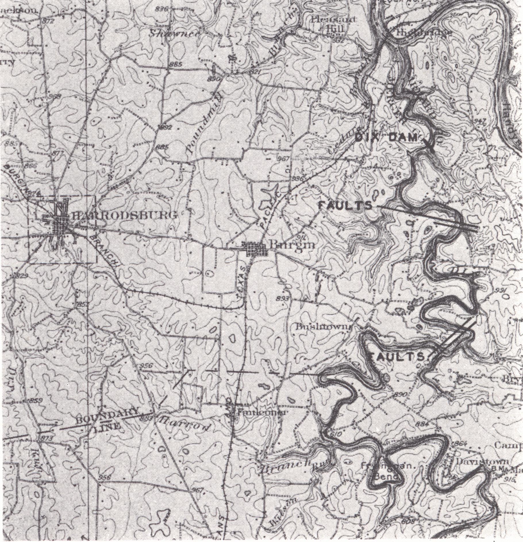
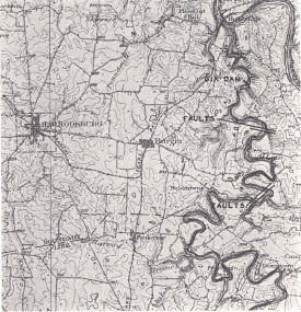
FIG. 23. Faults crossing Lake Herrington
shown on
a part of the Harrodsburg topographic sheet |
FALLS OF THE OHIO.—The Falls of the Ohio (pls.
I and
X) is a rapids in the Ohio
River at Louisville, which is responsible for the location of that city. This
was a matter of the necessary transfer of cargo at that point in early
transportation of freight by flatboat and steamboat. It was later developed for
hydroelectric power.
The development of the falls is described by Fenneman (1938, pp. 444, 445):
"The Falls of the Ohio at Louisville are interesting because they constitute the
sole significant interruption of an otherwise graded stream. The river here
drops 26 feet in less than 2 miles. Presumably the river was fairly graded
before its valley was aggraded 150 feet by outwash from the ice sheet. On the
low shale plains around Louisville the filling spread widely and the river
flowed here and there, coming finally to a single fixed channel a few miles
north of its old course. When filling ceased and downcutting began, a strong
limestone was encountered at 400 feet A. T., whereas its old channel, discovered
by drilling on the opposite (southeast) side of the city, was only 360 feet
above the sea (Butts, 1915, p. 204). The Ohio is therefore superposed on its own
alluvium at this point."
The geological set-up involves the regional westward, downstream dip of the
Louisville, Jeffersonville, and Sellersburg limestones with the overlying New
Albany and Ohio shales. The limestones form the local "hold-up" to valley
deepening. The weaker shales have been stripped and the water cascades down the
dip slope of the limestone, which is much roughened by irregular erosion, with
the development of pot holes, minor channels, and erosion along joints. These
give rise to minor cascades. An earlier falls along the channel through downtown
Louisville had apparently been pretty well erased when alluviation by glacial
floods destroyed the old drainage line and the slow cutting of a new channel was
begun again.3
CUMBERLAND FALLS.—Cumberland Falls was brought to popular attention some years
ago by the controversy waged over its utilization for power purposes. By act of
legislature the region was set aside for a state park and has been developed for
that purpose. It is a rugged region characteristic of the lower Pottsville
outcrop differing from the Natural Bridge vicinity of Powell and Wolfe counties
in that the Rockcastle conglomerate outcrop here is in the valley bottom. The
falls with a drop of almost 70 feet resulted from the interruption of valley
deepening by the outcropping Rockcastle conglomerate. It is situated on the
Cumberland River about 40 miles above Burnside and 27 miles below Williamsburg
in a deep valley carved into an upland capped with the Corbin sandstone. The
path of recession of the falls from the Pottsville Escarpment near Burnside is
marked by a gorge in which the conglomerate gradually descends from a hilltop
position on the front of the cuesta to the level of the falls. While downstream
undercutting originally was principally in the shales of the Pennington and
shaly sandstones of the basal Pottsville, recession has carried the falls
upstream a dozen miles above outcrop of Mississippian rocks. The falls is now
maintained by differences in "hardness" between beds within the Rockcastle
member. In recent years access to the falls has been facilitated by a highway
from Corbin and another from the west. A ferry is in operation and at low water
the river is easily forded just above the falls.
| PLATE LXIX |
 |
FIG. 1.
Cumberland Falls, McCreary-Whitley counties (Caufield and Shook).
The cap rock is Rockcastle conglomerate. |
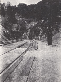 |
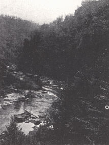 |
FIG. 2.
Louisville and Nashville Railroad
tunnel through Cumberland Mountain at
Cumberland Gap. Chattanooga shale is
exposed in the cut. |
FIG. 3. Breaks of the Sandy in
Pike
County. The gorge is cut in the Lee
conglomerate brought to the surface in an
anticline just beyond the termination of the
Pine Mountain overthrust in the Russel
Fork fault. |
BREAKS OF THE SANDY.—The Russell Fork of the Big Sandy follows the Russell Fork
fault for about 6 miles in Dickenson County, Virginia, to the southern foot of
Pine Mountain, then swings northeast for a couple of miles and around the
northeastern end of Pine Mountain in the "Breaks." This fault constitutes the
northeastern margin of the Pine Mountain thrust block and crosses Pine Mountain
through Skegg Gap, on both sides of which Lee conglomerate caps the ridge. To
the northeast it dips off rapidly to drainage, and the conglomerate, with a
little Mississippian below, outcrops in the broad Pine Mountain anticline,
across which the gorge of the Russell Fork, known as the Breaks of the Sandy,
has been cut. It is a rugged deep gash typical of the conglomerate outcrop about
2000 feet below the crest of Pine Mountain in the vicinity of Skegg Gap and 1000
feet below the hilltops to the northeast.
REELFOOT LAKE AND THE NEW MADRID EARTHQUAKE.4—Reelfoot Lake is located in the
Purchase region of western Tennessee with the northern end extending into Fulton
County, Kentucky. It was formed at the time of the New Madrid earthquake of 1811
and following years. The sinking of a considerable area of land was apparently
involved in the movement causing the earthquake.
The first shock is reported as having occurred at 2:00 A.M., December 16, 1811,
followed by repeated shocks at short intervals throughout the 16th and 17th.
Severe shocks occurred on January 23 and February 7, and the latter fully
equaled or surpassed any of the earlier ones. Small disturbances continued for a
year or so, none of which were destructive. The more severe disturbances are
described (Fuller, 1912, p. 10) from the correspondence of witnesses:
"The ground rose and fell as earth waves, like the long, low swell of the sea,
passed across its surface, tilting the trees until their branches interlocked
and opening the soil in deep cracks as the surface was bent. Landslides swept
down the steeper bluffs and hillsides; considerable areas were uplifted, and
still larger areas sunk and became covered with water emerging from below
through fissures or little "crater-lets" or accumulating from the obstruction of
the surface drainage. On the Mississippi great waves were created, which
overwhelmed many boats and washed others high upon the shore', the return
current breaking off thousands of trees and carrying them out into the river.
High banks caved and were precipitated into the river, sand bars and points of
islands gave way, and whole islands disappeared."
Earthquake shocks in the Mississippi Valley, though uncommon, were not unknown
and several had been reported for a century or more earlier. Indian legend
recognized a great earthquake which had formerly devastated the region. There
is also geologic evidence of earlier earthquakes (Fuller, 1912).6 See also page
149.
(a) The presence of cracks as large as those of the last disturbance with trees
fully 200 years old in their bottoms, and slopes.
(b) Post-Lafayette—pre-Iowan faults (antedating deposition of loess) have been
observed in Crowley Ridge.
(c) Glenn (1906) has described sandstone dikes in the Eocene Porters Creek clay.
These are regarded as earthquake phenomena.
(d) The Tiptonville, Blytheville, and Little River domes are regarded as
earthquake phenomena. They existed prior to 1811.
The area involved, as indicated by domes, sunk lands, fissures, sinks, sand
blows, large landslides, etc., is a narrow belt between Crowley Ridge and
Chickasaw Bluffs (50 miles plus) and from Cairo to the latitude of Memphis. The
tremors were felt (not instrument recordings) over half the area of the United
States as far away as New Orleans, Detroit, Washington, D. C., and Boston.
Louisville and Cincinnati were visited by strong tremors. The area lies in a
region characterized by a maze of older faults, covered by the sedimentary
blanket of Cretaceous, Tertiary, and Quaternary rocks of the Mississippi
Embayment. Presumably an occasional movement has continued and the belief is
expressed by Fuller that the shock originated in a northeast-southwest fault
located about 15 miles west of the Mississippi River. This is based on the
extent of the destruction and the recorded direction of movement. A shock
originating in the loose materials of the embayment deposits could hardly be
transmitted to the Paleozoics below and then across the continent as recorded.
The Mississippi Embayment is a geosynclinal area as indicated by the thick body
of Tertiary and Quaternary alluvium. The disturbance may have originated in a
further deepening of this trough with resulting lateral compression giving rise
to the domes and "sinks." Reelfoot Lake is an example of the latter. Its
irregularity apparently indicates that the basin is not entirely a matter of
subsidence but includes land over which water has been ponded by uplift at its
southern end. The amount of subsidence relative to adjoining tracts is normally
5 to 10 feet, perhaps as much as 15 to 20 feet.
BIG BONE LICK.—Big Bone Lick is in western Boone County 4 miles east of the Ohio
River. It is a locality which had long been frequented by the Indians for game
and to make salt from the natural brine. Reports from white visitors in the
eighteenth century of the unusual spectacle of "big bones" scattered over the
ground created something of a sensation. Colonel George Croghan went there in
1765, and mentioned the wide buffalo trail he followed to the Lick. E. T.
Hutchins on his map of 1778 published in London designated the spot as "Big
Bones."
| PLATE LXX |
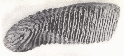 |
FIG. 1. Mammoth (Elephas)
tooth from the Pleistocene of Big Bone Lick,
Boone County. |
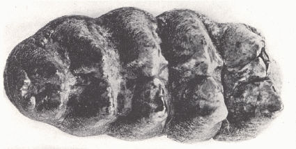 |
| FIG. 2. Mastodon tooth (Mammut)
from the Pleistocene of Johnson County. |
 |
|
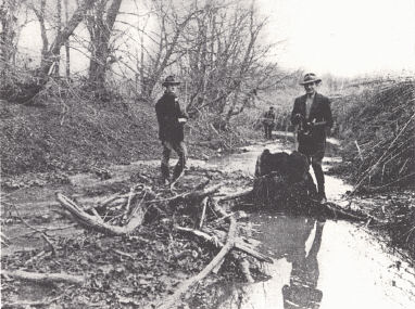
FIG. 3. Old Salt Spring at Big Bone Lick, Boone County. |
A number of large collections have been made from this Lick and shipped out,
though it is remarkable how limited the amount of material is in museums in this
and foreign countries. The first known collection was that of Robert Smith, an
Indian trader, in 1774. The large collection made by Colonel George Croghan in
1765 was lost when the field party was attacked by Indians. A later collection
made by him went in part to Benjamin Franklin and the rest was shipped to
London. President Thomas Jefferson had a collection made by Captain William
Clark for the Philadelphia Philosophical Society and also the National Institute
of France. The intense interest and speculation in the scientific world,
particularly as to the nature of the mastodon tooth, is shown in the several
selections from writings of that time (from Jillson, 1936):
London
August 5, 1767
Col. George Croghan:
Sir:
I return you many thanks for the box of elephants' tusks and grinders. They are
extremely curious on many accounts; no living elephant having been seen in any
part of America by any of the Europeans settled there, or remembered in any
tradition of the Indians. It is also puzzling to conceive what should have
brought so many of them to die on the same spot; and that no such remains should
be found in any other part of the continent, except in that very distant
country, Peru, from whence some grinders of the same kind, formerly brought, are
now in the museum of the Royal Society. The tusks agree with those of the
African and Asiatic elephant in being nearly of the same form and texture, and
some of them notwithstanding the length of time they must have lain, being still
good ivory. But the grinders differ, being full of knobs, like the grinders of a
carnivorous animal; when those of the elephant, who eats only vegetables, are
almost smooth. But then we know of no other animal with tusks like an elephant,
to whom such grinders might belong.
It is remarkable, that elephants now inhabit naturally only hot countries where
there is no winter, and yet these remains are found in a winter country; and it
is no uncommon thing to find elephants' tusks in Siberia, in great quantities,
when their rivers overflow, and wash away the earth, though Siberia is still
more a wintry country than that on the Ohio; which looks as if the earth had
anciently been in another position, and the climates differently placed from
what they are at present.
With great regard, I am, Sir,
Your most obedient humble servant, B. Franklin
Letter6 written a year later, 1768, to Abbe Chappe:
London
January 31, 1768 Abbe Chappe7
Sir:
I sent you sometime since, directed to the care of M. Molini, a bookseller near
the Quay des Augustins, a tooth that I mentioned to you when I had the pleasure
of meeting with you at the Marquis de Courtanvaux's. It was found near the River
Ohio in America, about 200 leagues below Fort du Quesne, at what is called the
Great Licking Place, where the earth has a saltish taste that is agreeable to
the buffaloes and deer, who come there at certain seasons in great numbers to
lick the same. At this place have been found the skeletons of near 30 large
animals suppos'd to be elephants, several tusks like those of elephants, being
found with these grinder teeth —four of these grinders were sent me by the
gentleman8 who brought them from the Ohio to New York, together with 4 tusks,
one of which is 6 feet long and in the thickest part near 6 inches diameter,
and also one of the vertebrae—my Lord Shelbourn receiv'd at the same time three
or four of them with a jaw bone and one or two grinders remaining in it. Some of
our naturalists here, however, contend that these are not the grinders of
elephants but of some carnivorous animal unknown, because such knobs or
prominences on the face of the tooth are not to be found on those of elephants,
and only, as they say, on those of carnivorous animals. But it appears to me
that animals capable of carrying such large and heavy tusks, must themselves be
large creatures, too bulky to have the activity necessary for pursuing and
taking prey; and therefore I am inclin'd to think those knobs are only a small
variety, animals of the same kind and name often differing more materially, and
that those knobs might be as useful to grind the small branches of trees, as to
chaw flesh—however I should be glad to have your opinion, and to know from you
whether any of the kind have been found in Siberia.
With great esteem and respect, I am Sir
Your most obedt huml Servant
B. F.
The first general description of Big Bone Lick to appear in an American book was
penned by John Filson:9
"At a salt spring near Ohio River, very large bones are found, far surpassing
the size of any species of animal now in America. The head appears to have been
about three feet long, the ribs seven, and the thigh bones about four; one of
which is deposited in the library at Philadelphia, and said to weigh 78 pounds.
The tusks are above a foot in length, the grinders about five inches square and
eight inches long. These bones have equally excited the amazement of the
ignorant, and attracted the attention of the philosopher. Specimens of them have
been sent both to France and England, where they have been examined with the
greatest diligence, and found upon comparison to be the remains of the same
species of animals that produced those other fossil bones which have been
discovered in Tartary, Chili, and several other places, both of the old and new
continent. What animal this is, and by what means its ruins are found in regions
so widely different, and where none exists at present, is a question of more
difficult decision. The ignorant and superstitious Tartars attribute them to a
creature which they call Maimon, who, they say, usually resides at the bottom of
the rivers, and of whom they relate many marvelous stories; but as this is an
assertion totally divested of proof, and even of probability, it has justly been
rejected by the learned; and on the other hand it is certain that no such
amphibious animal exists in our American waters. The bones themselves bear a
great resemblance to those of the elephant. There is no other terrestrial animal
now known large enough to produce them. The tusks with which they are equally
furnished, equally produce true ivory. These external resemblances have
generally made superficial observers conclude that they could belong to no other
than that prince of quadrupeds; and when they first drew attention of the world,
philosophers seem to have subscribed to the same opinion. But if so, whence is
it that the whole species has disappeared from America? An animal so laborious
and so docile, that the industry of the Peruvians, which reduced to servitude
and subjected to education species so vastly inferior in those qualities, as the
llama and the paca, could ever have overlooked the elephant, if he had been to
be found in their country. Whence is it that these bones are found in climates
where the elephant, a native of the torrid zone, cannot even subsist in his wild
state, and in a state of servitude will not propagate? These are difficulties
sufficient to stagger credulity itself; and at length produced the enquiries of
Dr. Hunter. That celebrated anatomist, having procured specimens from the Ohio,
examined them with that accuracy for which he is so much distinguished. He
discovered a considerable difference between the shape and structure of the
bones and those of the elephant. He observed from the form of the teeth that
they must have belonged to a carnivorous animal; whereas the habits of the
elephant are foreign to such sustenance, and his jaws totally unprovided with
the teeth necessary for its use, and from the whole he concluded, to the
satisfaction of naturalists, that these bones belonged to a quadruped now
unknown, and whose race is probably extinct, unless it may be found in the
extensive continent of New Holland, whose recesses have not yet been pervaded by
the curiosity or avidity of civilized man. Can then so great a link have
perished from the chain of nature? Happy we that it has. How formidable an enemy
to the human species, an animal as large as the elephant, the tyrant of the
forests, perhaps the devourer of man. Nations, such as the Indians, must have
been in perpetual alarm. The animosities among the various tribes must have
been suspended till the common enemy who threatened the very existence of all
should be extirpated. To this circumstance we are probably indebted for a fact,
which is perhaps singular in its kind, the extinction of a whole race of
animals from the system of nature."
Thomas Jefferson regarded the mastodon as arboriverous. Shaler (1876) made an
important contribution in the recognition of a stratigraphic arrangement of the
bones. He found from top down:
(e) Buffalo, bear, and deer.
(d) Caribou and elk.
(c) Equus cf. complicatus.
(b) Mastodon ohioticus.
(a) Elephas primigenius and Bootherium.
The general geology is well known. In the bottoms of Big Bone Creek Pleistocene
and Recent alluvium is found to a considerable thickness. These are materials
more or less continuous with the Wisconsin and Illinoian terraces (valley
train) recognized at Cincinnati and vicinity along the Ohio River, and involve
the aggrading of the valley floor of this creek by backwater from the glacially
flooded Ohio and the ponding of the creek by the aggrading of the Ohio River
Valley. The situation is the same as in the alluvial filled valleys of western
Kentucky. It is these loose and unconsolidated sediments which cover the old
floor of Big Bone Creek valley in which these mammalian remains are found.
The waters of the several springs forming this lick are regarded as having
originated in the artesian salt-sulphur water (Blue Lick) of the St. Peter
sandstone, which occurs here at a depth of about 900 feet. George Croghan
(1765)10 reported the muddy part of the lick to have been about three-fourths of
an acre. Insofar as there was ponding of the Big Bone Lick creek waters in
Pleistocene, the swampy portions of the valley floor may have once been more
extensive. This would also have been the situation in connection with backwater
from the flooded Ohio River, either glacial or more recent.
Pleistocene and more recent animals coming in for salt were trapped in the mire
and entombed. The list of fossil mammals given by Hay (1923, quoted by Jillson,
1936, pp. 117-118) is as follows (modified):
Edentata
Megalonyx jeffersoni, giant Pleistocene ground sloth.
Mylodon harlani, small
glacial ground sloth.
Perissodactyla
Equus complicatus, American Pleistocene horse.
Tapirus haysii, Pleistocene
tapir.
Artiodactyla
Odocoileus virginianus, Virginia deer.
Cervus canadensis, Roosevelt elk or wapiti.
Cervalces scotti, "Stag-moose" or reindeer.
Alces americanus, moose.
Rangifer caribou, caribou.
Bootherium bombifrons, Pleistocene musk-ox.
Symbus cavifrons, musk-ox.
Bison antiquus, large glacial bison or buffalo.
Bison bison, small modern bison or buffalo.
Bison latifrons, a giant Pleistocene bison with tremendous horns.
Platygonus compressus, peccary or American swine.
Proboscidia
Mammut americanus, Pleistocene mastodon.
Elephas primigenius, small Siberian mammoth.
Elephas columbi, large American mammoth.
Carnivora
Ursus americanum, American black bear.
The fossils are chiefly species found elsewhere in the Wisconsin drift (Leverett,
1929). Hay (1923) cited Mylodon harlani and Equus complicatus as species not
known elsewhere to have survived the Wisconsin and regards Symbus cavifrons and
Bison antiquus as species of the pre-Wisconsin
Blue Lick.—Though other salt licks were numerous, important fossil finds have
been made only at Lower Blue Lick along the Licking River in Nicholas County.
These were made as the result of excavation in the vicinity of the spring
undertaken as a result of the spring's going dry. The remains included the
mammoth and mastodon, and the assemblage and occurrence were much like that of
Big Bone Lick.
Vertebrate remains have occasionally been found elsewhere in the state.11 Gravel
pits in northern Kentucky composed of glacial outwash have been productive of
tusks, teeth, and other bones of the mammoth. The mastodon is known from the
Green River valley and from Magoffin County in the Eastern Coal Field. Remains
of the mastodon and ground sloth were uncovered in excavations in a cave near
Cave City (Webb, 1934). A giant beaver the size of a black bear is represented
by scattered remains from eastern Kentucky. The tapir Tapirus sinensis is known
from McConnel's Run in Scott County and Yarnellton Station, Fayette County. The
peccary has been found in Wayne County. The only carnivore that has been found
is the black bear.
Footnotes
1 The Natural Bridge of Virginia has for years been regarded as the type example
of one mode of origin of natural bridges. The general concept was that of a
waterfalls in which the stream above the falls was diverted underground through
gradually enlarged crevices to emerge again low in the face of the original
falls. This left the rock shelf over which the stream originally plunged as a
span of rock (bridge) over the stream. Woodward (1936) has shown that this is
not the case and the common usage of the term "Natural Bridge of Virginia type"
loses its significance, at least in the old sense.
2 Figured by Miller, 1919, fig. 83, p. 211.
3 Something of a variation in the details of this commonly recognized picture
was given by Fowke (1933). According to this worker the pre-glacial drainage did
not involve an Ohio River at Louisville but instead a northward flowing Salt
River (into Indiana) with two tributaries, the upstream portions of which are
now represented by the headwaters of Harrods Creek (Indiana) and Beargrass Creek
(Kentucky). The surface rock forming the falls is a remnant of the rock divide
between the two creeks. The "old channel of the Ohio River" he regarded as the
former channel of Beargrass Creek through the city, later filled with drift.
4 These notes are mainly from Fuller, 1912.
5 Also Science, n.s., vol. 21, 1905, pp. 349-350 and Pop. Sci. Mo.,
July, 1906, p. 86.
6 The Writing of Benjamin Franklin. Ed., by Albert H. Smith. Vol. 5, p. 92.
7 Abbe Chappe D'Auteroche (1722-1769), astronomer and author of "Voyage en
Siberie" (1768).
8 Colonel George Croghan.
9 John Filson: The Discovery, Settlement, and Present State of Kentucke, pp.
33-36, Wilmington, 1784.
10 Published in 1831.
11 For a general outline see Miller, 1919, and Cooper, 1931.