COAL
SECTION A
It is not known that coal was recognized by the Indian in Kentucky, other than
for the occasional use of cannel coal for the carving of trinkets. Yet it occurs
in abundance in the region crossed by the Warrior's Trail from Cumberland Gap
northeast to the mouth of the Little Scioto River. The first recorded discovery
is that by Dr. Thomas Walker on April 13, 1750.1 He had entered the state at the
head of a small party through Cumberland Gap (Cave Gap) and found coal a few
miles to the north.
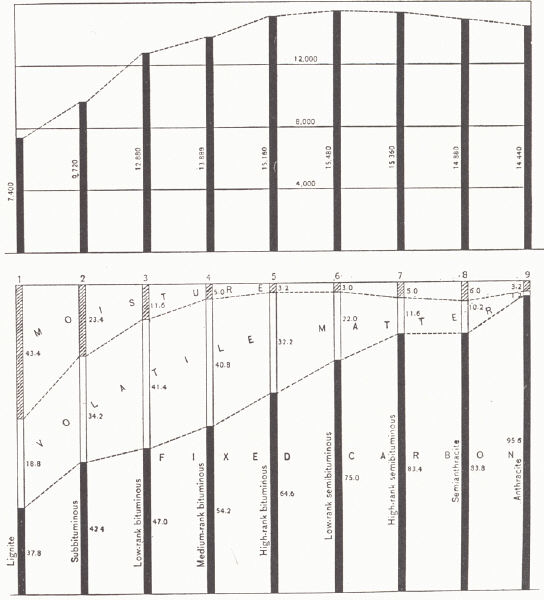 |
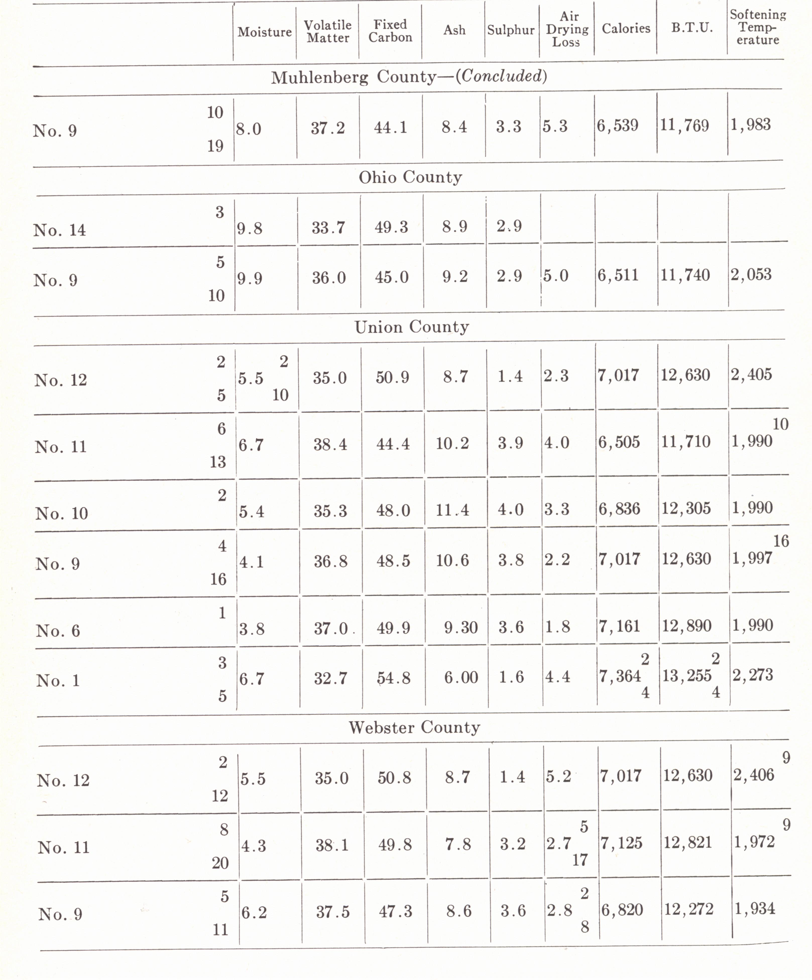
FIG. 24. Diagrams showing the chemical
composition and heat efficiency of the several ranks of coal.
Upper diagram: comparative heat value of the samples of coal represented in
the lower diagram,
computed on the ash-free basis. Lower diagram: variation in the fixed
carbon, volatile matter, and
moisture of coals of different ranks from lignite to anthracite, computed on
samples as received on the
ash-free basis (Campbell, 1929). |
The first record of coal production in the state is that of 328 tons mined in
1828 (Rice, 1922). Gradual development followed to 1907 from which year on the
industry expanded rapidly as a result of: (a) the introduction of improved
mining machinery, (b) the building of railroads into virgin territory of eastern
Kentucky about 1912, (c) the expansion of the by-product coke industry and the
suitability of much of eastern Kentucky coal for this use, and (d) a somewhat
lower price than in the unionized competitive fields.
 |
|
FIG. 25. Coal production in Kentucky,
1886-1938 |
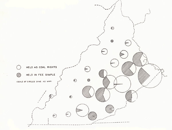
| Plate LXXII |
 |
| Coal-producing districts of
Kentucky |
As indicated in plate LXXIII, figure 1, for the past decade Kentucky has
alternated with Illinois in third and fourth position as a producer and is
exceeded in tonnage produced by Pennsylvania and West Virginia. Development
took place earlier in the western Kentucky field than in the eastern because of
greater accessibility—a matter of topography and the Ohio River. As pointed out
in an earlier chapter, the rugged topography in the vicinity of the Pottsville
Escarpment in the west and the Pine Mountain-Cumberland Mountain region in the
east, together with the greater relief and more rugged landscape of the eastern
field as a whole, constituted a barrier to transportation and development. In
spite of its somewhat superior coal and more of it, not until 1911 did
production from the eastern field surpass that of the western.
| Plate LXXIII |
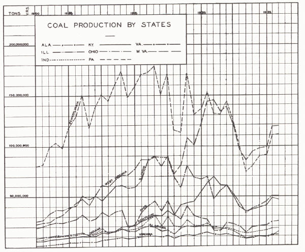 |
| FIG. 1. Coal production by
states, 1900-1937 |
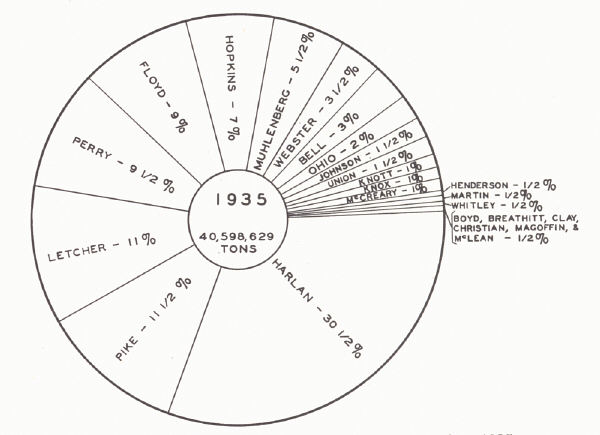 |
| FIG.2. Kentucky coal
production by counties, 1935 |
SECTION B—EASTERN COAL FIELD
The eastern field constitutes a part of the Appalachian Coal Field and includes
all or parts of 37 counties, totaling about 10,400 square miles. The bulk of
production comes from 17, with Harlan, Pike, Letcher, Perry, Floyd, and Bell
counties leading in the order given (pl. LXXIII, fig. 2; pl. LXXIV, fig. 1). The
coals are high in volatile matter, low in sulphur and ash, and relatively high
in heating value. The highest grade coals are found in the easternmost region
bordering the belt of Appalachian deformation. Here a maximum fixed carbon
content and heating value is found and there is progressive decrease to the west
and northwest.
| Plate LXXIV |
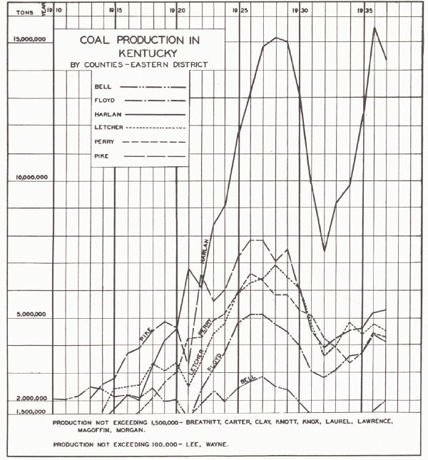 |
| FIG. 1. Coal production in
Kentucky by counties, 1910-1937 (Eastern District) |
 |
| FIG. 2. Coal production in
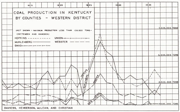
Kentucky by counties, 1910-1937 (Western District) |
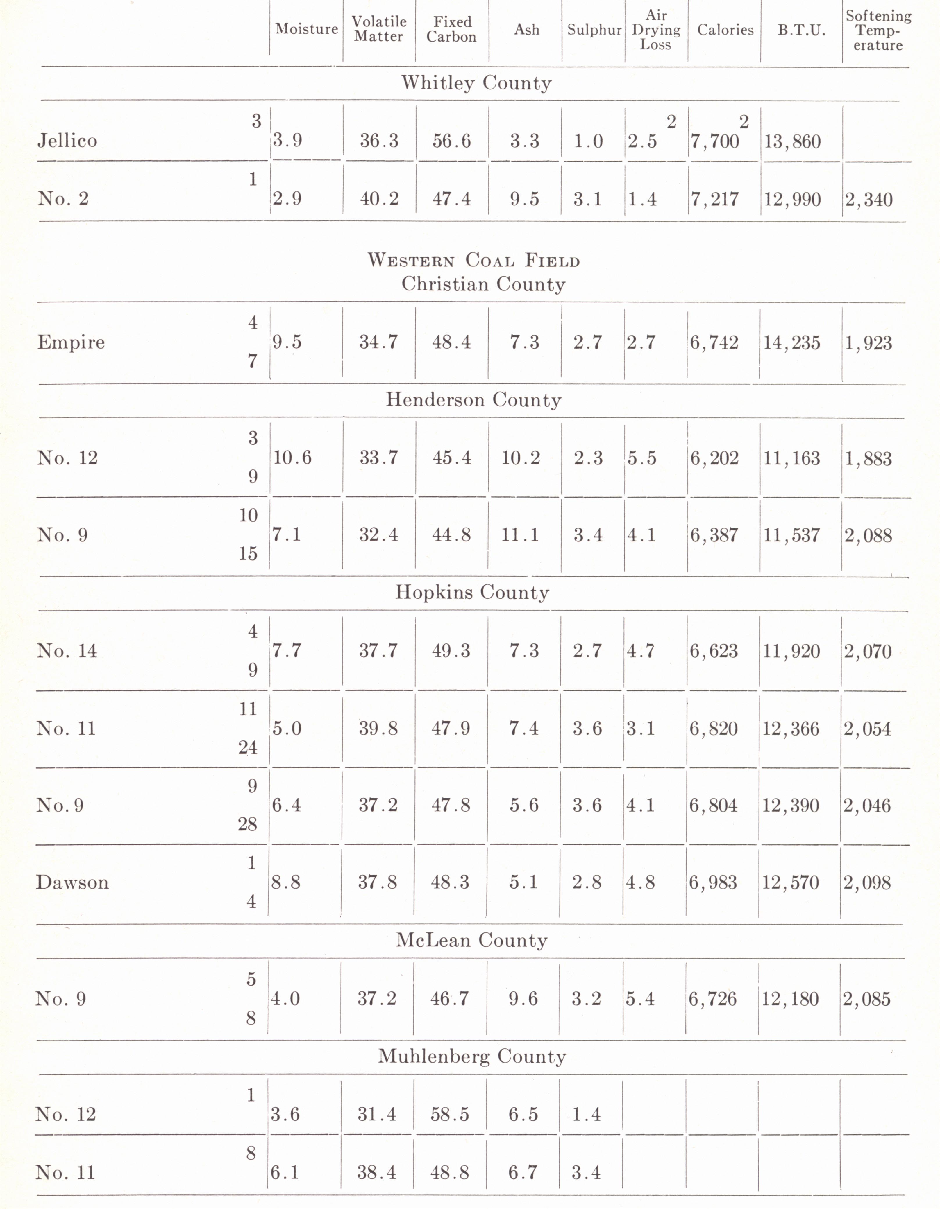
An average of many analyses shows a heating value of about 14,000 B.T.U. (13,000
to 14,500) in the Harlan-Bell County region. This decreases to 12,000± along
the western border of the field and is about the same in western Kentucky. In
Illinois it averages around 11,000 B.T.U. and in Iowa 10,000 to 11,000. A
sulphur content (marcasite) of less than 1 per cent in the eastern counties
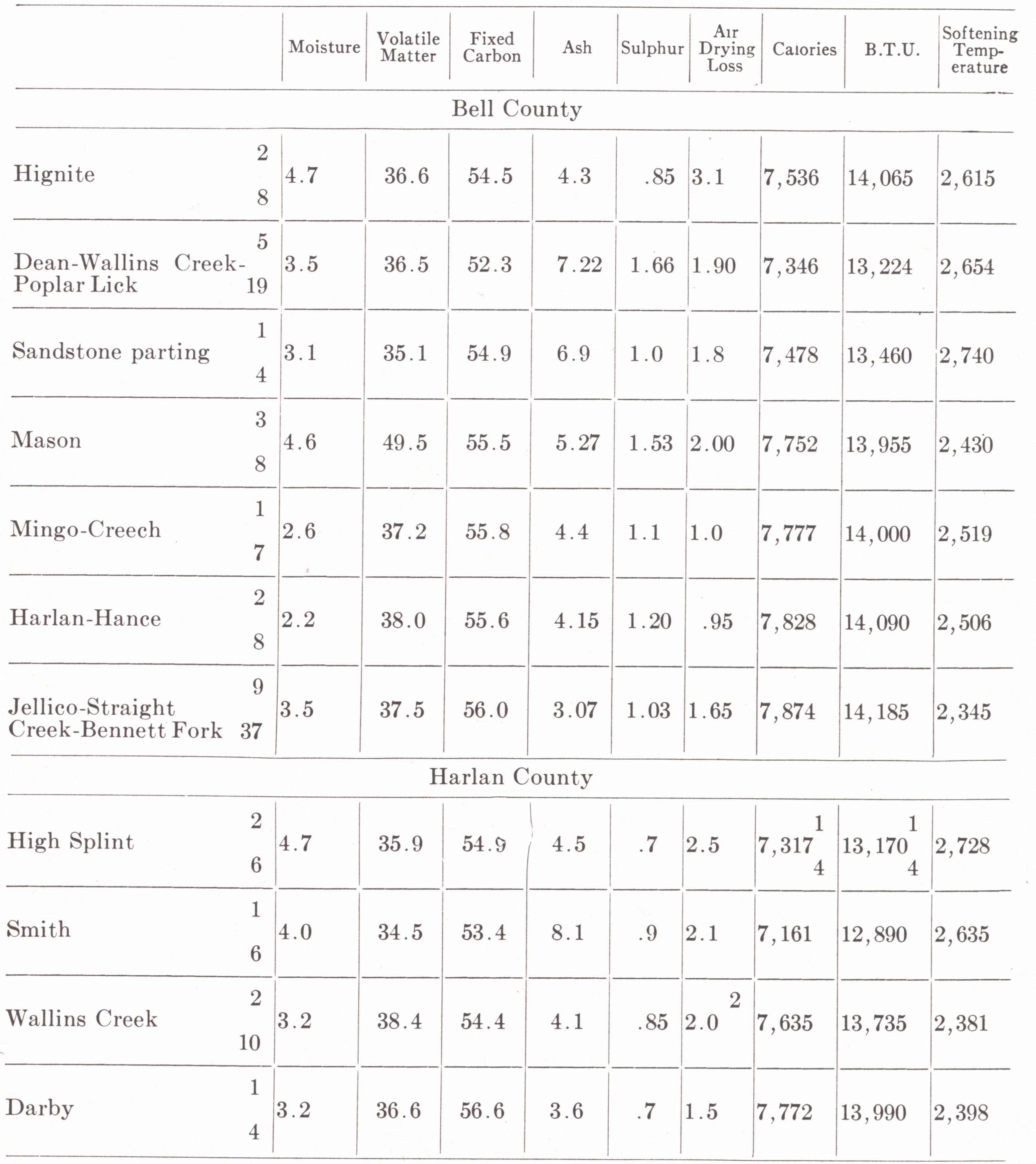
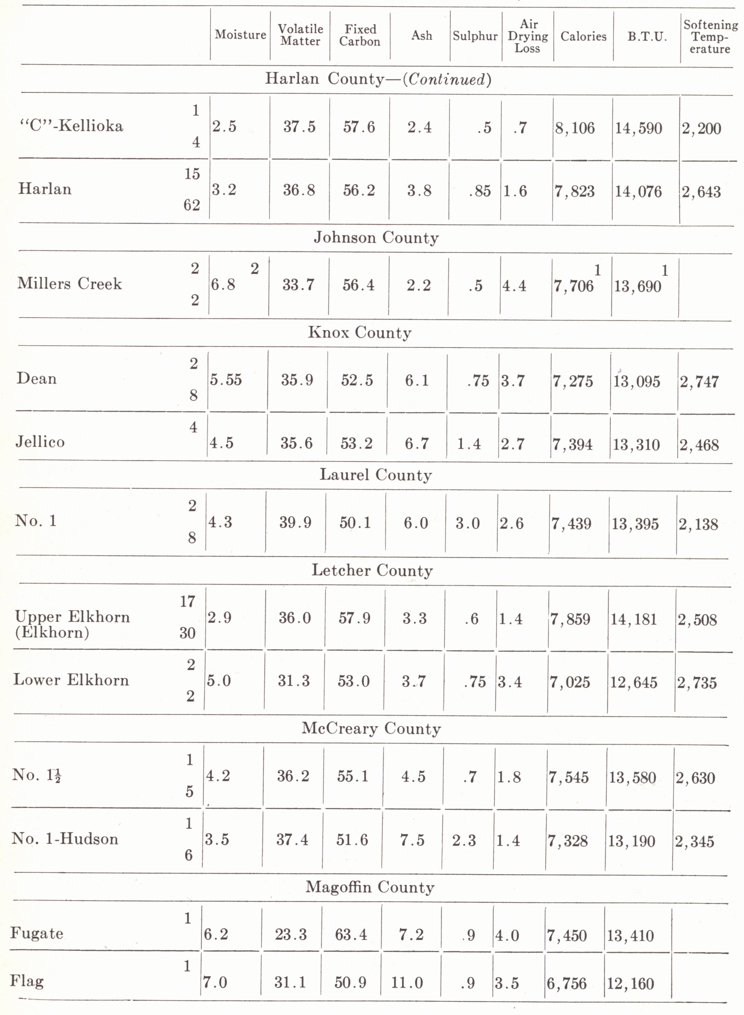
increases to 1 to 3 percent in the western counties. An outline summary of
analyses by counties is given below.
The high quality is reflected in the fact that the coal from these three eastern
Kentucky fields finds its way into nearly every state east of the tier of states
capped by the Dakotas, excepting those east of Pennsylvania and West Virginia (Theis,
1926). This means that they invade the natural markets of the coals of Ohio,
Illinois, Tennessee, and Alabama as well as those farther west in Iowa, Kansas,
and Arkansas.
The main use is for by-product coke and illuminating gas. Investigations of the
United States Fuel Administration in 1917 showed that 87 per cent of the
northeastern Kentucky production, 52 per cent of the Hazard production, and 44
per cent of the production of southeastern Kentucky were suitable for the making
of coke. On the other hand only 6.5 per cent, 13.7 per cent, and 17.9 per cent
from these same regions were used for railroad fuel (Tryon, 1922).
The exploitation of the field is behind that of its neighbors. Some individual
fields such as Harlan (1911) and Perry (1911) are of relatively recent
operation. "While West Virginia has exhausted one-eightieth of her reserves of
coal (counting as reserves all seams of more than fourteen inch thickness)
Kentucky has exhausted only one-two hundredth (½%)" (Theis, 1926, p. 5).
Wentworth (1927) estimated the minable coal of the Middlesboro Basin to be
4,314,000,000 tons of which less than 2% has been mined.
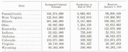
ESTIMATED ORIGINAL TONNAGE OF BITUMINOUS COAL AND THE
RESERVES,
JANUARY 1, 1939, IN THE LEADING COAL PRODUCING STATES*
(In thousand tons) |
 |
|
* Albert Pierce: The Growth and
Overdevelopment of the Kentucky Coal Industry, 1912-1929,
University of Kentucky Thesis, 1930 (revised to 1939). Adapted from
estimates of original
tonnage of coal in the United States by Marius R. Campbell.
† Approximately 55 per cent is in the eastern field. |
Cannel coals2 were first mined near Cloverport on the Ohio River in 1855.
Important deposits in western Kentucky are restricted to Breckinridge and
Hancock counties. In eastern Kentucky cannel coal is widespread but commercial
thicknesses are not of great extent, and it is commonly produced as a part of a
major bituminous operation. The better known seams are3 the Cannel City coal (=
Van Lear) of Morgan County, the Hunnewell cannel No. 4 of Carter and Greenup
counties, the Abbott Creek cannel of Floyd County (Elkhorn No. 1), and the
Chenoa cannel (probably = Bennett Fork = Harlan) of Bell County.
The Eastern Coal Field occupies the eastern flank of the Cincinnati arch and the
section from Pine Mountain thrust fault eastward. Within the field the most
prominent structure west of Pine Mountain is the broad syncline referred to as
the Eastern Kentucky geosyncline by the Kentucky Geological Survey (plate
XXXII). This down warp is responsible for the preservation of the youngest beds
and this preservation of beds is greatly accentuated by the thinning of the
Pennsylvanian section to the north in Boyd and Lawrence counties and vicinity.
Elsewhere over most of the field the Allegheny is present only on hilltops.
The region is maturely dissected, with thus a minimum of flat upland and bottom
land. Hilltop elevations range from 1000 feet in the northeast to 3800 feet and
more in the southeast. Local relief similarly varies from about 500 feet to 2000
feet plus.
The region is drained by the Big Sandy, Licking, Kentucky, and Cumberland
rivers. None are open to navigation within the area of the coal field except the
Big Sandy in its lower part. The valleys are of importance, though, in supplying
access for railroads serving the fields. The Licking Valley has not been greatly
used for this purpose and no field of consequence is located along it except
that of the Cannel City coal area.
Northeastern Kentucky Fields (Big Sandy or Elkhorn field including mines in
Boyd, Floyd, Carter, Johnson, Knott, Lawrence, and Letcher counties).—The mines
on the west bank of the Tug Fork in Pike and Martin counties are considered a
part of the Kenova-Thacker field of West Virginia. The greatest demand is from
the by-product coke ovens, coal gas plants, and steel works using coal gas. The
coal is too high priced for wide use as railroad fuel. Ten to 15 per cent is
used for domestic fuel because it is hard and lumpy. Geographic position
minimizes shipping to the east so the bulk moves north and west across the Ohio
River. The coals are in classes two and three with respect to fusibility of
ash.4
Hazard Field (Perry, Breathitt, and Lee counties).—The chief demand is from the
retail trade (domestic) for the free burning and blocky Hazard coal. The coal is
shipped to the north and west.
Southeastern Kentucky Fields (Bell, Clay, Knott, Laurel, McCreary, Whitley, and
Harlan counties).—The uses are much as in the northeastern field except a larger
proportion is used for railroad fuel, and smaller proportion for gas, by-product
coke and general industrial purposes. The ash rates classes one and two in
fusibility.
DISCUSSION BY DISTRICTS
Big Sandy Drainage5
Princess District (located in Boyd and Carter counties and served by the
Chesapeake & Ohio Railroad).—This is the least important of the recog-nized and
named coal fields. The Pennsylvanian section is thin and the coals in general
inferior to those farther south. The principal producer is No. 7 (Coalton =
Middle Kittanning) and No. 3 (Hitchens). Other commercial seams include No. 5,
No. 6, and No. 8 (Jillson, 1924a), but these are not listed as producers in the
more recent reports of the State Mine Inspector. No. 7 has a thickness of 42 to
46 inches, and No. 3 about 32 inches. The coals are relatively thin but
proximity to the Ohio River has enhanced their value.
Kenova-Thacker District (located on the Tug Fork of the Big Sandy River in
Martin and eastern Pike counties, and served by the Norfolk and Western
Railroad. It is continuous with the coal-producing area adjoining in West
Virginia).—Production is mainly from the Pond Creek = Freeburn = Warfield = No.
2 Gas seam which usually runs between 44 and 48 inches thick. The Thacker is a
poor second but the name has been applied to so many seams that it has little
stratigraphic significance, and production figures are correspondingly of little
value. Other important production comes from the Alma and Winefrede seams.
Thicknesses listed give the Warfield 52 inches (40-78), Thacker, 51 inches
(40-72), Alma, 44 inches (36-52), and the Winefrede, about 58 inches. Elsewhere
in Martin County other coals of considerable thickness are found. The Peach
Orchard coal is thick but is commonly ruined by partings. The Broas ranges from
52 to 85 inches and the Hindman is said locally to thicken to 5| feet.
Paintsville District (located on the Levisa Fork of the Big Sandy River in
Johnson and Floyd counties and centering around Paintsville).—It is served by
the Chesapeake & Ohio Railroad. Production comes from the several seams of the
Upper Elkhorn. In the northern part of the field (mainly Johnson County)
production is from the Millers Creek (Van Lear). To the south the Elkhorn No. 3
is the most important.
The Dwale, a lower coal (probably = Wayland) has been worked in the southeastern
part of Johnson County and has a thickness of 42 inches over considerable area.
About one-third of this county is listed as coal land. Several minor seams have
also been worked in Floyd County.
The Millers Creek (Upper Elkhorn No. 1), where mined, has a thickness up to 63
inches and the usual range is from 42 to 46 inches. The Upper Elkhorn averages
around 48 inches and has a maximum listed of 96 inches. Thicknesses of more than
50 inches are not uncommon.
Elkhorn District (located at the head of Levisa Fork of the Big Sandy River in
Pike County and the North Fork of the Kentucky River in Letcher County; it is
served by the Chesapeake & Ohio Railroad).—The bulk of production comes from the
Elkhorn seam which has a reputation for by-product coking. There is considerable
confusion in the differentiation of the Upper Elkhorn (Elkhorn) into the
Elkhorn No. 1, No. 2, and No. 3, and uncertainty as to meaning when the term
Elkhorn alone is used. Under the circumstances no attempt to differentiate them
is made in plates LXXVI and LXXVII.
The entire area of Pike County, which includes both the Kenova-Thacker field on
Tug Fork and the Elkhorn field on Levisa Fork, is classified as coal land.
Letcher County has workable coals throughout. In addition to those mentioned
above Theis (1926) listed the Hamlin (up to 5 feet) in the central part; the
Haddix, Flag, and Hindman (above 5 feet) in the southwestern corner; and the
Shelby Gap (Lower Elkhorn—from 54 inches to 60 inches plus) in the Cumberland
River drainage.
A number of mines in Letcher County list a thickness of 90 inches or more, and
Theis (1926) mentions thicknesses up to 10 and 12 feet.6 An average of mined
coals for Pike County gives 48 inches and for Letcher County 65 inches. In Pike
County the Lower Elkhorn is an important producer. In Letcher County, in
addition to the Elkhorn, No. 4 is an important producer, and the Whitesburg, Low
Splint, No. 4 Rider, and High Splint less so.
Lawrence County.—Lawrence County has produced some coal. The upper Mercer (No.
4) is probably the most important in the county (Theis, 1926) with a thickness
of 5 feet clean near Louisa. Other commercial coals include the Lower Mercer (=
Elkhorn), and in the southern part of the county, the Peach Orchard and
Richardson. No. 7 is listed in the report of the State Mine Inspector as a small
and the only producer in 1928.
Licking River Drainage
Morgan County.—This county is important only in cannel coal production from the
No. 2 = Van Lear seam centering around Cannel City, and was formerly served by
the Ohio & Kentucky Railroad. About 10 per cent of the county is rated coal
land.
Magoffin County.—Magoffin County is essentially undeveloped, but only about 25
per cent is coal land. Small production is listed but there is some confusion in
the identity of the producing seam. The 1928 production from the Tip Top mine
is listed as Hindman, and that for 1935 is listed as Millers Creek. The former
is probably incorrect. The Fire Clay coal is widespread but thin (20 to 30
inches). Theis (1926) found workable thicknesses along the Breathitt County line
and called attention to the Whittaker coal (approximate horizon of the Hazard
No. 6) with a thickness of 42 to 54 inches plus in the extreme southern tip of
the county at the main head of the Licking.
Kentucky River Drainage
Hazard district (located mainly in Perry County but including a little of
southwestern Knott County on the North Fork of the Kentucky River).—The field
was opened in 1912 with the completion of the Louisville & Nashville Railroad
through Perry County. Main production is from the No. 4 (Fire Clay), No. 6
(Hazard), and No. 7 (Flag) seams. A little production is also listed from No. 9
and No. 5. Average thicknesses of the main producing seams are No. 7, 52 inches
(40 to 56); No. 6, 56 inches (40 to 78); and No. 4, 38 inches (32 to 50).
Knott County is touched by railroad only at its northeast and southwest corners
and, as a result, has been little developed. It lies low structurally and thus
has a large exposed section of coal strata so that a large part of the county is
listed as coal land. In addition to the coals of the Hazard field, the
Whitesburg (36 to 46 inches) in the southern part, the Van Lear (36 to 48
inches), and Elkhorn (54 to 60 inches) on the Big Sandy drainage in the east are
commercial coals.
Breathitt County (North and Middle forks of Kentucky River).—Breathitt County is
essentially undeveloped except the area south of Jackson along the North Fork.
The No. 4, No. 6 (Hazard), and No. 4 Rider are of importance in the order named
with a total of only a half million tons (plus) production in 1928. The few
mines reporting give No. 4 an average of 42 inches (36 to 46 inches), one mine
reporting the No. 4 Rider 36 inches, and one the No. 6 (Hazard) 40 inches. Along
Troublesome Creek the Flag coal has a thickness of 42 to 48 inches. The writer
is unable to identify with assurance the "Jackson coal" listed in 1928 and
responsible for more or less 21 per cent of the county's total. However, Miller
(1919) listed the No. 3 or Elkhorn as the coal mined at Jackson so this
presumably is the "Jackson coal."
Clay County (South Fork of Kentucky River).—Limited production is listed from
the Horse Creek seam. This coal is probably the Lily = Manchester. Jillson
(1924b) listed the Blue Gem as worked along with the Horse Creek.
Coals of commercial thickness are not widespread in the county. Along the
western edge adjacent to Leslie County and again in the southeastern corner the
Fire Clay coal attains a thickness up to 4½ feet. Locally, on Goose Creek the
Howard coal is 4 feet thick.
Leslie County (Middle Fork of Kentucky River).—This county is undeveloped
because of lack of railroad facilities. The distribution of com¬mercial coal
seams is summarized by Theis (1926, p. 26):
"Probably the best coal land in this county centers around Hyden, near the
center of the county, where the Fire Clay coal shows a thickness of 54 inches.
From Hyden south, on the waters of Middle Fork this coal varies from 36 inches
to less than 24 inches. Along the southern boundary the Hazard coal in places
shows a good thickness. On Cutshin Creek, in the eastern third of the county,
the Fire Clay shows a thickness of about 42 inches as far south as the latitude
of Hyden and further south only about 30 inches. On the headwaters, against the
Perry County line, the Hazard coal reaches thicknesses of about 4.5 feet. On the
tributaries of Red Bird Creek of the South Fork of the Kentucky River, in the
western portion of the county, the Fire Clay coal is variable, ranging from
thicknesses of 42 to 48 inches in the north to less than 24 inches in the
south."
Cumberland River Drainage
Cincinnati Southern District (McCreary County—served by the Kentucky &
Tennessee Branch of the Southern Railroad).—Production comes from four seams in
the lower few hundred feet of the Pennsylvanian. Most of the production is from
the No. 1 (Hudson) and No. 1½ seams, and small amounts from the No. 2 (Beaver
Creek) and No. 3 (Barren Fork) seams. Thicknesses of these seams are: No. 3—37
inches (34-40); No. 2—46 inches (44-48); No. 1½—44 inches (42-48); No. 1—44
inches (40-48).
Jellico District (Whitley County—served by the Louisville & Nashville
Railroad).—Main production is from the Jellico seam with minor amounts from the
Blue Gem which is usually mined along with the other. Both the Bacon Creek
(Lower Blue Gem) and the Lily (Sharon) have been mined. The Jellico averages
about 35 inches (30-40) in thickness. The Blue Gem averages about 2 feet. The
lower coals mentioned under McCreary County (Nos. 1, 1½, 2, and 3) are present
in thicknesses of 30 to 36 inches in the northwestern part of the county. In the
section of Whitley County bordering Bell and Knox counties (Southern Appalachian
Field) the Dean is of commercial thickness and extent.
Laurel County.—Laurel county has been a small producer for a good many years
from the Lily seam. In recent reports of the State Mine Inspector the Laurel and
Jellico are both listed, the former of which is the Lily. Some of the operations
have been strip mining at East Bernstadt, Pittsburg, London, etc.
Southern Appalachian District (located in Bell and Knox counties and served by
the Louisville & Nashville Railroad).—The field continues south-ward into
Tennessee and to the north is continuous with the Harlan field. There are at
least seven producing seams, of which the Straight Creek (Jellico of Knox
County) and Mingo are outstanding. Small producers include the Harlan, Turner,
Mason, Dean, and Hignite. The Straight Creek has been correlated in the past
with the Blue Gem (Chisholm, Miller, and Theis, 1926), the Harlan (Jillson,
1924a), and the Jellico (Miller, 1919). This correlation by Miller was confirmed
by the recent work of Wanless. It is used chiefly as a steam and domestic coal.
Thicknesses listed are:
Hignite.................................... 45”
(42-54)
Dean (Poplar Lick)................. 49” (32-72)
Mason................................... 42” (38-52)
Mingo (Creech)..................... 52” (48-60)
Jellico.................................... 43” (42-44)
Straight Creek....................... 36½” (30-42)
Harlan................................... 46” (40-48)
Turner................................... 60” (42-82)
Harlan and Benham Districts.—The Harlan District centers around the town of
Harlan in Harlan County and the Benham occupies the northeastern end of the
county. The region is served by the Louisville & Nashville Railroad and in part
by the Southern. In the Harlan district, three-fourths of the coal mined comes
from the Harlan seam. Other outstanding seams are the Kellioka (= Elkhorn = No.
3 = "C") and Wallins Creek (Dean). The Harlan is a hard block coal and is used
for all purposes, including by-product coking. The Benham district relies mainly
on the Keokee (= Kellioka). Harlan County leads the state in production.
Thicknesses of producing seams are:
No. 10............................................................. 60"
No. 7 Middle Kittanning................................... 54"
High Splint,...................................................... 53" (40-62)
No. 6...............................................................
No. 5.............................................................. 44" (42-48)
Limestone........................................................ 60"
Dean-Wallins................................................... 46" (39-60)
Low Splint....................................................... 46" (39-60)
Creech = "E"................................................... 42"
Darby. ........................................................... 37½”" (32-42)
Kellioka = Keokee = No. 3 = "C" = Elkhorn... 66" (34-96)
Harlan............................................................. 44½" (34-67)
"B"......................... ........................................
| Plate LXXV |
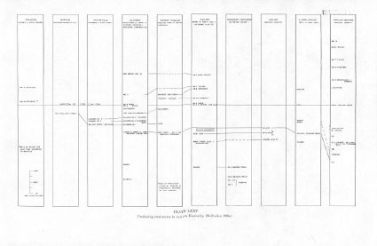
Plate LXXVI |
Plate LXXVII |
 |
 |
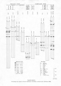 |
| Producing coal
seams in eastern Kentucky (McFarlan 1938e) |
Producing coal
seams in Eastern Kentucky
Coal Field—northern half (McFarlan 1938e) |
Producing coal seams in
Eastern
Kentucky Coal Field—southern
half (McFarlan 1938e) |
| Plate LXXVIII |
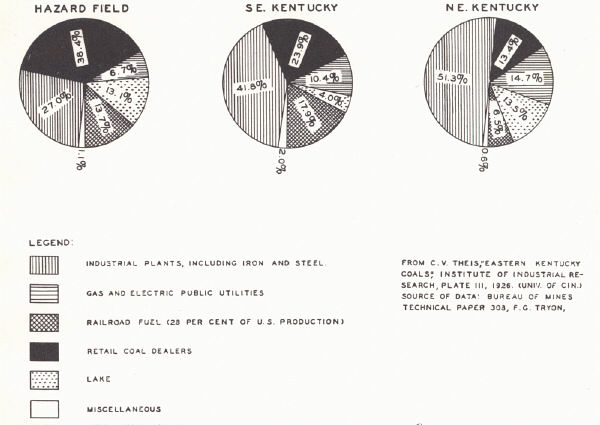 |
| FIG. 1. Use distribution of
eastern Kentucky coals (Theis, 1926) |
 |
| FIG. 2. Proportion of land in
eastern Kentucky taxed as coal land by counties (Theis, 1926) |
COALS OF THE EASTERN COAL FIELD7
"A" Coal (Harlan County).—In Wise formation, upper Pottsville; probably
equivalent to Imboden coal, Wise County, Virginia.
Alma Coal (West Virginia and Tug Fork region of Pike County, Kentucky).— Named
from locality on the Tug Fork of Big Sandy River near Sprigg, Mingo County,
southern West Virginia; in Kanawha group, between Campbell Creek and Cedar Grove
(above) coals; equivalent to Upper Elkhorn No. 1 coal in Pike County, Van Lear
in Johnson County, Harlan in Harlan County, Penny in Letcher County, and Moss in
Bell County.
Amburgy Coal.—Mined on Little Carr Fork (formerly called Amburgy Branch) of Carr
Fork of North Fork, Kentucky River, Knott County; in Breathitt formation,
between Elkhorn and Whitesburg (above) coals; equivalent to Wllliamson coal in
West Virginia.
Auxier Coal.—Type locality at Federal Mine No. 2 of Elswick Coal Company at
mouth of John Moore Branch of Russell Fork of Big Sandy River, near Elkhorn
City, Pike County; of lower Kanawha age, between Elswick and Millard (above)
coals; probably equivalent to Hagy coal in Virginia.
"B" Coal (Harlan County).—In Wise formation above the Harlan seam; also known as
Leonard; probably equivalent to Lower Cedar Grove coal in West Virginia.
Barren Fork Coal.—A minor commercial seam in the Lee formation between the
Rockcastle and Corbin conglomerates; mined on Barren Fork of Cumberland River
near Flat Rock, McCreary County.
Beattyville Coal.—Exposed at Beattyville, Lee County; in Lee formation, probably
below Rockcastle conglomerate.
Beaver Creek Coal.—A minor commercial seam named from Beaver Creek Mines,
McCreary County; also known as No. 2; in Lee formation below Rockcastle conglomerate;
probably equivalent to Beattyville coal.
Bennett Fork Coals.—Two coals mined at Winona Mine on Bennett Fork, southern
Bell County; in lower part of Mingo formation of Ashley; tentatively correlated
with Campbell Creek coal in West Virginia.
Bevins Coal.—Mined near store of J. M. Bevins on Bent Branch of John Creek, Pike
County; in Breathitt formation above Williamson coal; probably equivalent to
Fire Clay coal.
Bingham Coal.—Mined on E. B. Bingham property, on Ferrell Creek, southern Pike
County; in Kanawha group between Millard and Pond Creek (above) coals;
equivalent to Matewan coal in West Virginia and Clintwood coal in Virginia.
Blue Gem Coal.—A minor commercial seam below the Jellico: mined in Whitley
County.
Broas Coal.—Formerly mined by R. M. Broas, near head of Middle Fork of
Rockcastle Creek, southwestern Martin County. It comes below the Hindman coal
and below or in the lower part of the Puncheon Creek sandstone.
Brookville Coal.—See Haddix.
"C" Coal (Harlan County).—In Wise formation; equivalent to Keokee.
Cedar Grove Coal (Tug Fork drainage).—Mined at Cedar Grove, Cabin Creek dis¬trict, Kanawha County, West Virginia; equivalent to Taggart in Virginia and
Upper Elkhorn C in Pike County. Where a Lower Cedar Grove coal is recognized, it
is equivalent to Upper Elkhorn B.
Darby = "D".—A commercial seam of the Harlan-Benham field between the Kellioka
("C") and Creech (above).
Dean Coal.—Outcrops on Dean Branch of Greasy Creek, Bell County (north of Pine
Mountain fault); more commonly known as Fire Clay coal.
Dorchester Coal (Virginia).—Mined at Dorchester, a mile west of Norton, Wise
County, Virginia; the lowest member of the Wise formation, resting directly on
the Gladeville sandstone.
Elkhorn Coal.—A thick, extensively mined coal on Elkhorn Creek in the Elkhorn
field of Pike (Russell Fork drainage) and Letcher counties. There has been
considerable confusion in the use of the term. There is a Lower Elkhorn (Pond
Creek) and an Upper Elkhorn zone divided into the Upper Elkhorn No. 1 or A
(Alma), Upper Elk-horn No. 2 or B (Taggart Marker—Lower Cedar Grove) and Upper
Elkhorn No. 3 or C (Taggart—Cedar Grove). The last named is the principal
Elkhorn coal of Pike and Letcher counties and is the one commonly referred to
under the designation of Elkhorn.
Elkhorn Rider.—Twenty to 30 feet above Elkhorn coal in the southeastern
counties, though locally forming the top of it in Letcher County; Breathitt
formation.
Elswick Coal.—Mined in Federal Mine No. 1 of Elswick Coal Company on Russell
Fork of Big Sandy River, half a mile northwest of Elkhorn City, Pike County;
below Auxier coal; probably equivalent to Upper Banner Coal in Virginia.
Fire Clay Coal.—Contains a characteristic 4- to 6-inch parting of dark-colored
non-plastic flint fire clay below middle of coal; between Whitesburg and Hamlin
(above) coals; also called Dean, Hyden, No. 4, and Poplar Lick coals; probably
equivalent to Chilton coal of Mingo and Logan counties, West Virginia. The "fire
clay" parting has not been observed north of West Liberty, but that part of the
section here is marked by the Dingess limestone (lower Mercer limestone) below.
Fire Clay Rider.—A coal 20 to 50 feet above the Fire Clay coal and widespread
from Morgan County south; probably equivalent to the Chilton Rider in West
Virginia.
Flag Coal.—A cannel coal having the appearance of flagstone where weathered,
near mouth of Troublesome Creek, Perry County; between Hazard and Francis
(above) coals. An important coal in the Hazard field; a minor one in the Harlan.
Flag Rider.—A thin coal 20 to 40 feet above the Flag coal.
Francis Coal (Kentucky River drainage).—Mined by George Francis near the gap
between Yellow Creek of Carr Fork and Kelly Fork of Lots Creek in southwestern
Knott County; between Flag and Hindman (above) coals.
Freeport Coal.—See Lower and Upper Freeport.
Fugate Coal.—Between Flag Rider and Hindman (above) coals in Magoffin County;
overlies the High Rock sandstone and horizon of the Francis coal.
Gun Creek Coal.—Exposed on Gun Creek, southeastern Magoffin County, between Tom
Cooper and Whitesburg (above) coals; has locally a thin flint fire clay parting
resembling that in the Fire Clay coal.
Haddix Coal (= Limestone coal).—Mined high in bluff of North Fork of Kentucky
River above Haddix, Breathitt County; between Hamlin and Hazard (above) coals;
correlated with Winifrede in West Virginia and Brookville coals in Pennsylvania
and Ohio. Cannel coal occurs at this horizon in Breathitt County and at what is
probably the same horizon in southern Lawrence County (Little Cannel coal); one
of the lesser producers of the Harlan field.
Hamlin Coal.—Probably named from outcrop on Hays Branch, near Lost Creek P. O.,
Perry County; between Fire Clay and Haddix (above) coals.
Harlan Coal.—Extensively mined at Harlan, Harlan County; low in the section and
probably equivalent to Lower Standiford coal, Wise County, Virginia; the
outstanding commercial seam of eastern Kentucky though more or less limited to
the Harlan field.
Hazard Coal.—Mined high in hills above Hazard, Perry County; in Breathitt
formation, between Haddix and Flag (above) coals; probably equivalent to Buffalo
Creek coal in West Virginia.
Helton Coal.—Mined by R. L. Helton, near head of Spruce Pine Creek of Middle
Fork of Kentucky River, southern Leslie County; above Hindman coal; the highest
coal mined in Kentucky River valley north of Pine Mountain fault.
Hignite Coal.—See Lower and Upper Hignite.
Hindman Coal.—Reported as 10 feet of coal near hilltop above Right Fork of
Troublesome Creek, 3 miles southeast of Hindman, Knott County; above Francis
coal; possibly equivalent to No. 5 Block coal in West Virginia and Lower
Kittanning coal in Pennsylvania and Ohio.
Howard Coal.—Mined by James Howard on Mine Fork, Magoffin County; between
Wheelersburg and Lacey Creek (above) coals.
Hudson Coal.—Named from Hudson mine on southern bank of Cumberland River,
between mouths of Laurel and Rockcastle rivers, McCreary County; in Lee
formation; the lowest commercial coal in western border of Eastern Kentucky
Field; a relatively important seam of the Cincinnati Southern Field.
Hyden Coal.—Mined near Hyden, Leslie County; equivalent to Fire Clay coal.
Imboden Coal.—Mined at Imboden on Pigeon Creek, western Wise County, Virginia;
in Wise formation between Rocky Fork and Kelly (above) coals; equivalent to
Campbell Creek coal in West Virginia.
Jellico Coal.—Principal coal mined in southern Whitley County, Kentucky, and
north of Jellico, Campbell County, Tennessee; above Blue Gem coal; tentatively
correlated with Campbell Creek coal in West Virginia and Imboden coal in
Virginia.
Kellioka.—See Keokee.
Keokee Coal.—An important coal at Keokee, Lee County, Virginia; in Wise
formation; equivalent to Taggart coal in Wise County, Virginia; a major
commercial seam in the Harlan-Benham field.
Klondike Coal.—Named from Klondike mine, head of Bennett Fork, Claiborne County,
Tennessee; in Catron formation, between Poplar Lick and Lower Hignite (above)
coals.
Lacey Creek Coal.—Mined on Lacey Creek, northern Magoffin County; between Howard
and Tom Cooper (above) coals.
Levi Coal.—Exposed at Levi, Owsley County; in Lee formation, between Travellers
Rest coal and Corbin conglomerate (above); probably equivalent to Barren Fork
coal (Cumberland River drainage).
Lick Creek Coal.— Mined in hills east of Lick Creek, southern Lawrence County,
above Torchlight coal.
Lily Coal.—Mined near Lily Station, south of London, Laurel County; in lower
part of Breathitt formation, below Bacon Creek coal; tentatively correlated with
Williamsburg and Manchester coals.
Limestone Coal.—Equivalent to Haddix.
Little Cannel Coal.—A thin canneloid coal exposed on Levisa Fork, south of
Louisa, Lawrence County; probably equivalent to Haddix coal.
Low Splint Coal.—A splint coal occurring low in Black Mountain in the Big Stone
Gap field, Wise County, Virginia; in Wise formation, between Taggart and
Phillips (above) coals; probably equivalent to Amburgy coal in eastern Kentucky
and Williamson coal in West Virginia; a producing seam of the Harlan-Benham
field.
Lower Freeport Coal.—The lower of two coals exposed at Freeport, on Allegheny
River, South Buffalo township, Armstrong County, western Pennsylvania; an upper
Allegheny coal of Carter and Boyd counties; equivalent to No. 8.
Lower Hignite Coal (Southern Appalachian Coal Field).—Mined on Hignite Creek,
Log Mountain, Bell County; basal member of Hignite formation; a small producer.
Lower Kittanning Coal.—Formerly called Kittanning coal, from exposures near
Kittanning, Armstrong County, western Pennsylvania; in lower Allegheny, between Vanport limestone and Middle Kittanning (above) coal; equivalent to No. 5 block
coal in West Virginia; equivalent to Richardson coal of Martin, Johnson, and
Morgan counties, Kentucky, and the No. 6 = Winslow coal of Carter and Boyd
counties; a commercial coal under the name of High Splint.
Manchester Coal.—Mined on Goose Creek and tributaries near Manchester, Clay
County; in lower part of Breathitt formation, between Corbin conglomerate and
Howard (above) coal; also known as Lily, Horse Creek, and Laurel.
Middle Kittanning Coal.—The middle of three coals exposed along Allegheny River
at Kittanning, Armstrong County, Pennsylvania; an important coal near middle of
Allegheny; a small producer in Boyd and Carter counties, Kentucky (Coalton
coal).
Millard Coal.—Mined on Russell Fork of Big Sandy River at Millard, Pike County;
between Auxier and Bingham (above) coals; probably equivalent to Eagle coal in
West Virginia.
Mills Coal.—Mined by Finley Mills on Toms Branch of Salt Gum Fork of Middle Fork
of Stinking Creek, Knox County; between Howard and Fire Clay (above) coals; may
be equivalent to Whitesburg coal.
Mingo Coal.—Named from Mingo No. 1 mine on Bennett Fork, Claiborne County,
Tennessee; near middle of Mingo formation, between Bennett Fork coal and
Sandstone Parting coal (above); an important producer in the Southern
Appalachian Field.
Moss Coal.—Mined by M. J. Moss on Four-Mile Creek east of Pineville, Bell
County, eastern Kentucky; in Breathitt formation between Straight Creek and
Howard (above) coals; equivalent to Van Lear, Harlan, etc., coals.
Peach Orchard Coal (Lawrence and Martin counties).—Mined at Peach Orchard on
Left Fork of Nats Creek, southern Lawrence County; equivalent to Coalburg coal
in West Virginia of upper Kanawha age and Francis (?) coal of Kentucky.
Pond Creek = Lower Elkhorn.
Poplar Lick Coal.—An important coal in the Log Mountain area, Bell County; basal
member of Catron formation; tentatively correlated with Fire Clay coal.
Prestonsburg Coal.—Mined near Dwale and Prestonsburg, Floyd County; below Van
Lear coal; probably equivalent to Warfield = Pond Creek = Lower Elkhorn coal =
Campbell Creek coal in West Virginia; under marine Dwale shale.
Red Spring Coal.—A coal outcropping high in Log Mountain, near head of Stony
Creek, Bell County; uppermost member of Hignite formation.
Richardson Coal (Lawrence and Martin counties). Mined at Richardson, on Levisa
Fork, Big Sandy River, southeastern Lawrence County, in lower part of Allegheny
between Lower Clarion coal and East Lynn sandstone (above); correlated with
Lower Kittanning in Pennsylvania and Ohio and No. 5 block coal in West Virginia.
Sand Gap Coal.—Locally mined at what is called Sand Gap between Lacey Fork of
Rockcastle River and Burdine Valley, Pulaski County; in Lee formation; probably
equivalent to Barren Fork coal.
Sharon Coal.—Extensively mined near Sharon, Mercer County, western Pennsylvania;
in Pottsville, between Sharon conglomerate and Lower Conoquenessing sandstone
(above); equivalent to Barren Fork coal of the Cumberland River region; has been
used incorrectly for Manchester = Lily of Kentucky.
Shelby Gap Coal (Letcher and Pike counties).—Mined on Elkhorn Creek near Shelby
Gap station, southwestern Pike County; tentatively correlated with Lower Elkhorn
in Pike County and Campbell Creek coals in West Virginia.
Splash Dam Coal.—Mined at the Splash Dam on Russell Fork of Big Sandy River
north of mouth of Pound River, Virginia. In Pike County, Kentucky, it occupies a
position between the Elswick and Auxier (above) coals.
Stamper Coal.—Exposed on Stamper property near head of Turkey Creek, a branch of
Line Fork of North Fork of Kentucky River, western Letcher County; above Hindman
coal; highest mined coal in southern Kentucky north of Pine Mountain; probably
equivalent to Hel ton coal.
Straight Creek Coal.—Extensively mined along Straight Creek, north of Pine
Mountain, Bell County; also known as Pineville coal; equivalent to Jellico
coal; an important commercial seam.
Tom Cooper Coal.—Exposed on land of Tom Cooper on Lick Creek, northern Magoffin
County; in Breathitt formation between Lacey Creek and Gun Creek (above) coals.
Torchlight Coal.—Mined at Torchlight, on Levisa Fork of Big Sandy River,
Lawrence County; equivalent to Peach Orchard coal.
Trace Fork Coal.—A thin coal exposed on Trace Fork, southeastern Magoffin
County; in Breathitt formation, between Fossil limestone and Young (above) coal.
Travelers Rest Coal.—A thin coal exposed near Travelers Rest, Owsley County; in
Lee formation, between Beattyville and Levi (above) coals.
Upper Freeport Coal.—Mined at Freeport, Armstrong County, western Pennsylvania;
the uppermost member of Allegheny formation; present in Boyd County and vicinity
in Kentucky.
Upper Hignite Coal.—Exposed near head of Hignite Creek, Log Mountain, Bell
County; in Hignite formation, between Lower Hignite coal and Red Spring
sandstone (above).
Van Lear Coal.—Extensively mined on Miller Creek at Van Lear, Johnson County;
probably equivalent to Upper Elkhorn No. 1 = Alma coal.
Warfield Coal.—An important coal mined on Tug Fork at Warfield, eastern Martin
County; in Breathitt formation; equivalent to Pond Creek = Lower Elkhorn coal
(Campbell Creek coal in West Virginia).
Wayland Coal.—Mined at Wayland, southern Floyd County; in Breathitt formation;
probably equivalent to Warfield = Lower Elkhorn coal.
Whitesburg Coal.—Mined near Whitesburg, Letcher County; in Breathitt formation,
between the Amburgy and Fire Clay (above) coals; tentatively correlated with
Upper Mercer coal of Ohio.
Whittaker Coal.—Mined by J. M. Whittaker on Grassy Creek, near head of Licking
River, southern Magoffin County; between Young and Hazard (above) coals.
Williamsburg Coal.—A coal just above the Corbin conglomerate; locally mined near
Williamsburg, Whitley County; probably equivalent to Lily and Manchester coals.
Winifrede Coal.—Mined extensively at Winifrede, Cabin Creek district, Kanawha
County, West Virginia; tentatively correlated with Haddix in eastern Kentucky,
Pardee in Virginia, and Brookvllle coals in Pennsylvania and Ohio.
Young Coal.—Mined by William Young, on Elklick Fork of Youngs Fork of Lots
Creek, Knott County; between Haddix and Hazard (above) coals.
Zelda Coal.—Mined near Zelda on Big Sandy River, northern Lawrence County; also
called No. 9 coal; equivalent to Upper Freeport.
No. 1 Coal.—Exposed on Barrett Creek, near Grayson, Carter County; also known as
Barrett Creek coal; above Corbin conglomerate; about the horizon of Quakertown
coal in Ohio. In McCreary County = Hudson* (also 1½).
No. 2 Coal.—Carter and Boyd counties; below Fire Clay coal; equivalent to Van Dusen coal in Ohio. In McCreary County = Beaver Creek.* Also = Van Lear.*
No. 3 Coal.—A number applied in the Kenova quadrangle, northeastern Kentucky, to
coals known as Lower Stinson, Torchlight, and McHenry seams. "The present study
suggests these coals are not all of same age" (Wanless, 1939, p. 109). Also =
Barren Fork.*
No. 4 Coal.—A number applied in Kenova quadrangle, northeastern Kentucky, to
coals known as Upper Stinson in Carter County, Catletts Creek in Boyd County,
and Lick Creek in Lawrence County. "The present study suggests these coals are
not all of same age" (Wanless, 1939, p. 110). A number generally applied to the
Fire Clay coal in Perry and adjacent counties. No. 4A = Fire Clay Rider.
No. 5 Coal.—A number applied to a coal in the lower Allegheny in Lawrence and
Boyd counties; also called Cat Creek coal in northern Lawrence County.
No. 6 Coal.—A number applied to Winslow coal in Kenova quadrangle; in lower
Allegheny; equivalent to Lower Kittanning coal. Also = Hazard.*
No. 7 Coal.—Mined in Boyd and Carter counties; also known as Coalton coal, from
Coalton, Boyd County; equivalent to Middle Kittanning. Also = Flag.*
No. 8 Coal.—A thin coal of northeastern Kentucky in upper part of Allegheny,
also called Hatcher coal; equivalent to Lower Freeport. In Perry County =
Francis.*
No. 9 Coal.—A thin coal at top of Allegheny, in Boyd, Carter and Lawrence
counties; also called Zelda coal; equivalent to Upper Freeport. Also = High
Splint* of Elkhorn and Hazard fields.
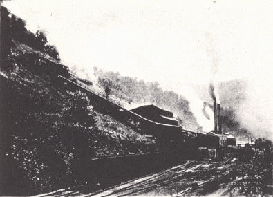
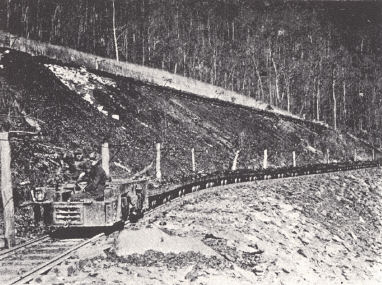
| PLATE LXXIX |
 |
 |
| FIG. 1. Coal mine near Benham,
Harlan County |
FIG. 2. Black Star Mine, Alva,
Harlan County |
 |
 |
| FIG. 3. Strip mining, Hopkins
County |
FIG. 4. Mining town,
Wilhoite, Bell County (Caufield & Shook) |
SECTION C—WESTERN COAL FIELD
Of the dozen or so counties in the Western field which have produced coal, only
five are important (one-half million tons per year or more)— Muhlenberg,
Hopkins, Webster, Union, and Ohio. Of the coals No. 9 (Springfield of Illinois)
is outstanding, with No. 11 (Herrin of Illinois) second. Other producing seams
include the Bell (Owen No. Ib), No. 4, Empire = Mannington, No. 6, No. 7, No.
12, and No. 14.
The first commercial operation was a drift mine on the Green River in Muhlenberg
County, opened in 1820 by William D. McLean. In 1825 several small mines were
started in Daviess County (Burroughs, 1925). The Breckinridge cannel coal was
mined in Breckinridge and Hancock counties as early as 1837 and in 1856 it was
used for the distillation of oil.
The relatively early development of the
western field was a matter of greater accessibility. Much of it is hilly but
relief is much less than in the eastern field and slopes not so steep. Major
valleys are commonly of great breadth due to extensive shale outcrop and
Pleistocene alluviation. This has covered much of the outcrop so that core
drilling is more commonly necessary than in the eastern field. Shaft mining is
rather characteristic along with drift and some stripping operations. Little
attempt is made to recover pillar coal, and recovery is about 60 per cent as
against 75 per cent in the eastern field (Herbert, 1922). The coals of western
Kentucky are chiefly in demand for steam raising, mainly by railroads, and also
for domestic use. The amount of coal suitable for use in by-product coke ovens
is small.
COMMERCIAL COAL SEAMS
Coals of the Caseyville Formation
There is little commercial coal in the Caseyville. The Nolin (Main Nolin) seam
has been mined and used locally in the Nolin River region of Grayson and
Edmonson counties and in northern Warren and southern Butler counties.
Breckinridge cannel.—This coal was mined in Breckinridge County and at Victoria
in Hancock County, and for a while, beginning in 1856, was distilled for oil. It
was a high grade cannel coal, varying from 2 to 4 feet thick. The last
production is listed from 1898 and closing of the mines presumably was the
result of exhaustion. Its correlation is uncertain as the Caseyville
conglomerate is not developed in this vicinity. The coal occurs 25 to 40 feet
above the base of the Pennsylvanian.
Coals of the Tradewater Formation
Commercial coal is produced from the Tradewater formation but not on a large
scale. Seams mentioned in the reports of the State Mine Inspector include the
Mannington = Empire, No. 4, No. 6, and No. 7.
The Mannington = Empire is the seam mined in northern Christian County and is
the same as the Dawson Springs coal of southern Hopkins County. The names
are taken from towns in these counties. A persistent limestone 30 to 45 feet
above the coal is an important means of identification. For this limestone zone
Glenn (1912) used the term Mannington limestone. It is at least near the horizon of
the Curlew limestone of Webster and Union counties. In Hopkins County, where
most extensively mined, the coal ranges from 40 to 54 inches thick. It is a
bright clean coal without parting and with little sulphur (Glenn, 1912). Crider
(1914a) mentioned a band of cannel coal up to 7 inches thick near the base in
the Dawson Springs Quadrangle.
In more recent reports of the State Mine Inspector production in Christian,
Muhlenberg, and Hopkins counties is listed from No. 6. As these are the same
operations formerly mining this coal under the name of the Empire, etc., coals,
apparently this seam has more recently been incorrectly identified as the No.
6. That seam was formerly mined at Dekoven and near Sturgis in Union County. The
thickness is about 4 feet and it was commonly referred to as the "Four-foot"
seam.
In the Owensboro region, involving Hancock and Daviess counties, the Hawesville
and the Lewisport are the only coals that have been commercialized on any
scale, though the Persimmon Run, Mason, Lead Creek, and Adair (40 to 44 feet
above the Lead Creek coal) have at one time or another been worked locally. The
Hawesville coal is lenticular and ranges up to 5 feet thick. It was mined in the
vicinity of Hawesville for about 60 years and the region was an important mining
center prior to the Civil War. It is a high grade coal, still the leading
producer, though small, and pretty well worked out in the vicinity of the Ohio
River. The Lewisburg coal averages somewhat thicker but slacks more readily. It
has been of importance, second only to the Hawesville. Coals listed as No. 4 and
No. 7 in state mining reports are very likely these seams.
No. 7.—This seam was formerly mined at Dekoven (Union County). Theis (1926)
reported it as locally of workable thickness in Henderson County, and some
production has been listed from it there, but not for the past seven or eight
years.
In northern Butler and Logan counties small wagon mines have worked a number of
local seams. These are indicated in section 5 of plate XXVII.
Coals of the Carbondale Formation
The Carbondale is the great coal-producing formation of the Western field. No. 9
and No. 11, supply the bulk of the coal.
No. 9 (No. 5 or Springfield coal of Illinois).—This is the standard coal of
western Kentucky and the mining of it is attended with fewer troubles than any
other coal in the region. While normally not attaining the thickness of No. 11,
the absence of dirt slips, clay partings, and the uniformity of the coal make
it the more desirable mining proposition (Crider, 1914). It is persistent,
without parting, and uniformly 4 feet 8 inches to 4 feet 10 inches thick.
Thicknesses of 6 feet 6 inches are listed from a number of mines in Hopkins
County. The roof is good, and formed of black shale which often contains
siderite or pyrite concretions (nig_er-heads) up to several feet in diameter.
Some of the thinner seams such as the Bell, Empire, and Baker (No. 14) may show
up better on analysis but are not so consistent. It is the main producer in
every county of the Western field except an occasional border county exposing
only the lowermost seams.
Ashley (1909a) has pointed out that this seam underlies some 25,000 square miles
and is probably the most persistent coal in the eastern half of the United
States. The famous Pittsburg seam underlies only 6,000 square miles or less.
No. 10.—This seam has been mined in a small way at Curlew and Dekoven in Union
County. Elsewhere it is not known to be of workable thick¬ness. It is not listed
as a producer in the 1928-1935 reports of the State Mine Inspector.
No. 11 (Herrin seam of Illinois).—The No. 11 ranks second in importance only to
the No. 9. It is generally considered not quite so good, for it is somewhat
dirtier, but analyses of the two are much alike. The ash comes mainly from the
"blue band" and gob at the roof. (See below.) This, however, is "extraneous ash"
and the coal can be cleaned. As a matter of fact, examination of many analyses
shows No. 9 to be slightly higher in ash. Here analyses of clean samples are
involved, and the matter is one of "inherent ash." No. 11 is less persistent and
uniform in thickness, though it actually attains greater thickness and ranges
up to 7 feet with an average of about 6 feet.
A characteristic section shows:
(e) top bench.
(d) "sulphur band," a quarter to half an inch of marcasite, 9 to 16 inches below
the top.
(c) middle bench.
(b) "blue band," 1½ to 2 inches of blue grey clay,
(a) lower bench.
The blue band is a characteristic feature. Equally characteristic is the
presence of the Providence limestone above, either forming the roof or separated
from the coal by a few inches of gob, or up to 4 feet of black shale.
As with No. 9, it is too high in sulphur for a good coking coal.
No. 11 is mined in most counties of the Western field except those of the
immediate border belt. Even here as in southern Hopkins, Muhlenberg, etc., the
seam has been preserved in downfaulted blocks.
No. 12.—This is a small producer in Hopkins and Webster counties. It is rather
unreliable in thickness though listed at about 6 feet where mined. Glenn (1922)
found it low in sulphur, the lowest in fixed carbon and moisture, and highest in
volatile carbon of the commercial coals. The roof is soft shale.
Coals of the Lisman Formation
With the exception of the Baker, a locally-developed thick coal near its base,
the Lisman is normally barren of workable coal.
Baker Coal.—This coal was discovered in the course of drilling for No. 9 between
Clay and Wheatcroft in Webster County and is known with certainty as a
commercial coal only from this vicinity. It ranges from 4 to 7 feet in thickness
and is low in sulfur and ash and volatile combustible matter. Because of a soft
clay roof, 12 to 14 inches of coal must be left to form a roof.
The Baker seam was regarded by Glenn (1922) as the No. 14 and Nebo (Earlington
vicinity). Wanless has more recently (1939) correlated it with No. 13. No. 14
listed from Hopkins County is apparently a little higher in the section.
| LXXX |
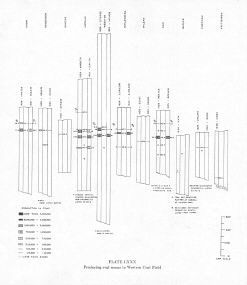 |
| Producing coal seams in
Western Coal Field |
COALS OF THE WESTERN COAL FIELDS
Aberdeen Coal.—Near middle of Tradewater formation; outcrops and is mined on
Green River at Aberdeen, Butler County; equivalent to Elm Lick and Ice House
coals.
Adair Coal.—Locally mined at Adair, Hancock County; in Tradewater formation,
between Lead Creek and Lewisport (above) coals; equivalent to Indiana coal II.
Baker Coal.—Named from Baker mine, near Clay, Webster County; in lower part of Lisman formation; probably equivalent to No. 13 coal.
Battery Rock Coal.—Formerly mined at Battery Rock on Ohio River, Hardin County,
Illinois, opposite Caseyville, Kentucky; in Caseyville formation, between upper
and lower conglomerates; probably equivalent to Sewell coal of West Virginia.
Beaver Dam Coal.—Thin coal exposed near Beaver Dam, Ohio County; in upper part
of Tradewater formation; probably equivalent to Davis coal.
Beda Coal— Outcrops near Beda, Ohio County, Kentucky; in Tradewater formation;
equivalent to Mannington and Topmiller coals.
Bell Coal.—Named from old Bell mines, 2 miles south of Caseyville in Crittenden
County; in lower part of Tradewater formation, between No. la coal and Finnie
sandstone (above); equivalent to Willis coal of southern Illinois.
Briar Hill Coal.—Mined first near Dekoven, Union County; in Carbondale
formation; equivalent to No. 10 coal of western Kentucky and No. 5a coal of
southern Illinois.
Cates Coal.—Locally mined by S. F. Gates near Grays Branch, southeastern Hopkins
County; in Tradewater formation, just below Curlew limestone and about 40 feet
above Mannington coal.
Curlew Coal.—Exposed on Indian Hill, Union County, between Curlew limestone and
Curlew sandstone (above); equivalent to Mining City (Butler County), Millsite
(Edmonson County), and Adair (Hancock County) coals and the No. II of Indiana.
Along the east side of the Basin it is rather persistently overlain by 1 to 2
feet of limestone varying from grey, argillaceous, and quite fossiliferous to
grey, massive, and sometimes cherty.
Davis Coal.—Named from Davis mine, east of Dekoven, Union County; in upper
Tradewater, below Dekoven coal; generally known as No. 6 coal, though it was
originally the No. 5 of Owen (1857); popularly known as the "Four-foot" coal.
Dawson Springs Coal.—Mined near Dawson Springs, southwestern Hopkins County; in Tradewater formation; equivalent to Mannington coal.
Dekoven Coal.—Outcrops near Dekoven Station, Union County; in upper Tradewater,
above Davis coal; known as No. 7 coal, though originally called No. 6 (Owen,
1857); a widespread seam known also as the "Three-foot" seam.
Elm Lick Coal.—Exposed on Elm Lick Creek, near Horton, Ohio County; in Tradewater formation, between Hamlin and Beda (above) coals; probably equivalent
to Aberdeen and Ice House coals.
Elmwood Coal.—Exposed near Elmwood School, southwest of McHenry, Ohio County; in Lisman formation, a few feet above No. 13 coal.
Empire Coal.—Mined at Empire, Christian County; in Tradewater formation;
equivalent to Mannington coal.
Gidcomb coal. Mined by J. W. Gidcomb on Green River two and one-half miles above
Morgantown, Butler County; in Tradewater formation between Bee Spring sandstone
and Amos coal (above); approximate position of Bell coal.
Goshen Coal.—Named from a locality in either Ohio or Butler County; equivalent
to 8b coal of Union and Hopkins counties, etc.
Hamlin Coal.—Exposed near Hamlin Chapel, northeast of Hartford, Ohio County; in
upper part of Tradewater formation below Elm Lick coal.
Hartford Coal.—A thin coal outcropping near Hartford, Ohio County; in upper part
of Tradewater formation, between Millsite and Beaver Dam (above) coals.
Hawesville Coal.—Extensively mined at Hawesville, Hancock County; near base of Tradewater formation; equivalent to Cannelton coal of southern Indiana. There is
some cannel coal, and the roof is normally canneloid black shale which is a
means of identification. It is believed to be Owen's la coal of Union County.
Ice House Coal.—Formerly mined near an ice house on the Ohio River, about 2
miles south of Dekoven, Union County; in Tradewater formation, above Finnie
sandstone; equivalent to Aberdeen coal.
James Mason Coal.—Mined by James Mason in Ohio River bluff 6 miles northwest of
Hawesville, Hancock County; in Tradewater formation between Hawesville and Lead
Creek (above) coals; probably equivalent to Elm Lick coal (Ohio County).
John Waltham Coal.—Mined by John Waltham at head of Pup Creek, 3 miles east of Knottsville, Daviess County; in Tradewater formation between Lewisport and Sam
Waltham (above) coals; probably equivalent to Davis (No. 5) coal.
Lead Creek Coal.—Mined on Lead Creek west of Hawesville, Hancock County; in Tradewater formation; equivalent to Minshall coal of Indiana and Rock Island
(No. 1) coal of western Illinois.
Lewisport Coal.—Mined in hills south of Lewisport, Hancock County; in
Trade-water formation, between Adair and John Waltham (above) coals; probably
equivalent to Stonefort coal in southern Illinois and Holland coal in Indiana.
Lisman Coal.—A thin coal, formerly mined a mile northeast of Lisman, Webster
County; in upper part of Lisman formation; may be equivalent to the Flannigan
coal of southern Illinois.
Main Nolin Coal.—Exposed along Nolin River, northern Edmonson County; Caseyville
formation between Kyrock conglomerate and Bee Spring sandstone (above);
equivalent to Battery Rock coal of Illinois.
Mannington Coal.—Mined near Mannington, northern Christian County; in Tradewater
formation, below Curlew limestone; known also as the Empire and Dawson Springs
coals.
Millsite Coal.—A thin coal in the Hartford quadrangle between Beda and Hartford
(above) coals; type locality not known; in Tradewater formation; equivalent to
Mining City coal.
Mining City Coal.—Mined along Green River at what was formerly called Mining
City, Butler County; in Tradewater formation about 30 feet above Curlew
limestone; equivalent to coal II of Indiana.
Mud River Coal.—Formerly worked at Mud River mine, southeastern Muhlenberg
County; in Tradewater formation; equivalent to Aberdeen and Elm Lick coals.
Nebo Coal.—Mined near Earlington, Hopkins County; in lower part of Lisman
formation; probably equivalent to Baker coal.
Persimmon Run Coal.—A thin coal exposed at mouth of Persimmon Run, near
Hawesville, Hancock County; in Tradewater formation, between Hawesville and
James Mason (above) coals.
Policy Coal.—A thin coal named from a locality near Catesville, Webster County;
in upper part of Bald Hill shale, Dixon formation, a little below the Vanderburg
sandstone.
Sam Waltham Coal.—--A thin coal mined by Sam Waltham on ridge between Pup and
Blackford Creeks, eastern Daviess County; in upper part of Tradewater formation;
probably equivalent to Dekoven coal.
Schultztown Coal.—A thin coal exposed near Schultztown school on Slaty Creek,
southern Ohio County; in Carbondale formation, between Beaver Dam and Goshen
(above) coals; correlated with Velpen or IlIa coal of Indiana and Colchester9
(No. 2) coal of Illinois. A marine limestone-shale zone above has been
correlated with the Oak Grove limestone of Illinois, where it is characterized
by the presence of Marginifera muricata and Mesolobus decipiens.
Smith Coal.—Named from Smith mine, in Crittenden County southwest of Sturgis; in Tradewater formation between Ice House coal and Curlew limestone (above);
probably equivalent to Mannington coal.
Topmiller Coal.—Mined on Topmiller place, 2½ miles east of Morgantown, Butler
County; in Tradewater formation, between Aberdeen sandstone and Gates coal
(above); equivalent to Mannington coal.
Upper Delong Coal (western Illinois).—A coal of the upper Tradewater formation,
above the Curlew sandstone with a persistent clay parting, suggesting the Fire
Clay coal of eastern Kentucky, of which it may be the equivalent (Wanless,
1939).
No. la Coal.—A thin coal exposed near Caseyville, Union County, a few feet above
top of Caseyville formation.
No. 2 Coal.—A thin coal in Union County, between Bell and Ice House (above)
coals; lower part of Tradewater formation.
No. 3 Coal.—A number applied to the Ice House coal, Union County; in Tradewater
formation.
No. 4 Coal.—A number applied by Owen to a coal between the Curlew limestone and
Curlew sandstone (above), in Union County, also known as Curlew coal; in Tradewater formation.
No. 5 Coal.—A number formerly applied to the Davis coal in western Kentucky, now
known as No. 6; Tradewater formation.
No. 6 Coal.—A number now generally applied to Davis coal, Union County; in upper
part of Tradewater formation.
No. 7 Coal.—A number applied to Dekoven coal, Union County; in upper Tradewater.
No. 8 Coal.—A number originally applied to a thin coal in Union County; also
known as Well coal; in lower Carbondale; probably equivalent to coal IIIa or IV
of Indiana.
No. 8b Coal.—A thin coal with black sheety shale roof in Carbondale formation;
equivalent to the Goshen coal and probably to the IVa or Houchin Creek coal of
Indiana, and No. 4 coal of southern Illinois. In Hopkins County and Ohio County
this coal is overlain by the black shale and in turn by the dark Hanover
limestone of Illinois. This marine zone is correlated (Wanless, 1939) with the
cap rock of the Mulky coal of Missouri and Lower Fort Scott limestone of Kansas
and Oklahoma.
No. 9 Coal (= No. 5 or Springfield and Harrisburg coals of Illinois and the
Petersburg or Alum Cave (No. 5) coal of Indiana).—This is the most important
coal of the Western Coal Field. The roof is black shale, sometimes containing
concretions of pyrite and side rite ranging up to several feet in diameter. The
shale is often fossiliferous and referred to as "Pennywinkle rock" (= St. David
limestone of Illinois). It is one of, if not the most, persistent commercial
coals in the eastern United States.
No. 10 Coal.—A thin coal in upper part of Carbondale formation; also called
Briar Hill coal; equivalent to No. 5a coal of southern Illinois, and Grape Creek
coal of eastern Illinois.
No. 11 Coal.—This is the second ranking coal of the field and comes in just
beneath the Providence limestone with a thickness of 2 to 6 feet. Equivalent to
the Herrin, No. 6 coal of Illinois.
No. 12 Coal.—A coal locally mined in western Kentucky; highest coal in
Carbondale formation; thickness 3 to 5 feet in some areas, though with numerous
partings in the eastern part of its extent in Ohio County; equivalent to
Millersburg coal of In¬diana and Jamestown coal of southern Illinois.
No. 13 Coal.—A thin coal overlying the Anvil Rock sandstone in lower part of Lisman formation; perhaps equivalent to Danville (No. 7) coal of Illinois.
No. 14 Coal.—A commercial coal of Ohio and Hopkins County; formerly regarded as
equivalent to the Baker but apparently a little higher in the section.
* Different local usage for same numerical designation.
Footnotes
1 First Explorations of Kentucky, J. Stoddard Johnston, 1898.
2 Mainly from Jillson, 1927c, pp. 83-85.
3 The stratigraphic position of No. 4 coal of Greenup and Carter counties
involves some uncertainty. In his work for the Kentucky Geological Survey,
Hudnall re¬garded it as equivalent to the Lower Torchlight and above the horizon
of the Fire Clay coal to which it has been referred by others. As used elsewhere
in Kentucky, No. 4 coal is the Fire Clay coal.
4 United States Bureau of Mines, Technical Paper 308.
Class 1—softens above 2600°F.
Class 2—softens 2200-2600°F.
Class 3—softens below 2200°F.
The increasing use of stoker coal has brought about a change in coal values as a
somewhat lower fusibility of ash is a desired feature.
5 Thicknesses here and in the following pages mainly from reports of the State
Inspector of Mines.
6 Partings included, not all minable.
7 From Wanless (1939) with minor additions and changes.
8 From Wanless (1989) with minor additions and changes.
9 This coal seam is described (Wanless, 1939) as the most widespread coal in the
Eastern Interior Coal Basin and tentatively correlated with the Lower Kittanning
coal of the Appalachian Field.