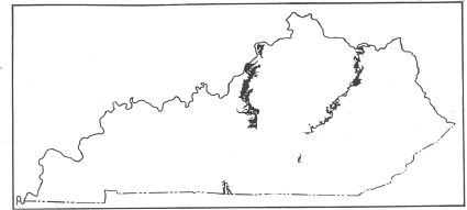
Fig. 26. Map of Kentucky showing outcrop of Silurian rocks.
By
AUGUST F. FOERSTE
THE SOURCE AND AFFINITIES OF THE SILURIAN FAUNAS
In prehistoric times the North American continent was invaded by oceanic faunas from various directions. The tilting of the continent toward the south permitted the invasion of oceanic faunas from the Gulf of Mexico, and tilting toward the east, permitted invasions from the North Atlantic. There have been invasions also from the Arctic and Pacific.
Some of these invasions extended far inland. Some from the Gulf of Mexico spread northward along the Mississippi embayment as far as the southern part of Canada, and some from the North Atlantic reached Ohio and Kentucky. As far as known, none of the invasions from the Arctic or Pacific reached Kentucky.
In most Silurian faunas, the brachiopod element predominates. Three of the southern invasions—the Brassfield, Osgood, and Waldron—are characterized by the abundance of bryozoans, in addition to the brachiopods. The Brassfield and Waldron contain also a considerable number of gastropods, pelecypods, cephalopods, and trilobites, all of which are relatively scarce in the Osgood and Louisville. In the Osgood, on the contrary, there are numerous cystids, though almost all of these were described originally under the single generic name Holocystites. The Waldron is characterized by the considerable variety of crinoids.
In the Laurel and Louisville bryozoans are rare. The Laurel is now characterized by numerous species of crinoids, a considerable number of which show affinities with crinoids occurring in Gotland and England. Possibly these invaded the American continent from some North Atlantic source. The Louisville fauna is characterized by the great number of species of its corals, the corals and brachiopods far exceeding in number all other elements. The Louisville fauna shows distinct relationship to the Brownsport fauna of western Tennessee, and probably represents a southern invasion, though not from precisely the same source as the Brassfield, Osgood, and Waldron faunas. The Louisville coral fauna is closely related also to that, of the Lockport in the northern part of Lake Huron, on Drummond and Manitoulin Islands.
The Brassfield fauna belongs to the upper part of the Medinan, and its areal distribution extends from Alabama, Georgia, and western Tennessee northward to southern Ontario and western New York. The Centerville fauna belongs to a distinctly older part of the Medinan, and is correlated provisionally with the Edgewood fauna of southwestern Illinois and Missouri. Both the Brassfield and Edgewood faunas are of southern origin.
In the Dayton fauna, the corals and brachiopods predominate. Although about equal in the number of species included, the corals predominate greatly in the number of specimens preserved. The Dayton limestone is correlated provisionally with the Walcott, at the top of the Lower Clinton. According to Ulrich and Bassler (Silurian, Maryland Geol. Survey, 1923, p. 333), the Walcott fauna contains no ostracods nor Anoplothecas, and is made up chiefly of types of bryozoans and brachiopods that, elsewhere in America, occur only in faunas that invaded the continent from the south.
The Euphemia, Springfield, and Cedarville may be regarded as successive incursions of essentially the same fauna, of which only the Cedarville element includes an abundance of species; among these are cystids and other species characteristic of the Racine of Wisconsin and Illinois. As in the case of the Laurel fauna, a considerable number of Cedarville and Racine crinoids are related to Silurian forms in Gotland and England, apparently having invaded the American continent from some North Atlantic source.
Among Silurian faunas confined to the eastern side of the
Cincinnati anticline, the Oldham is referred to the middle part of the Lower
Clinton, on account, of the presence of Zygobolba rectangula. This
suggests an age older than that of the Dayton limestone.
The Waco fauna is similar to the Dayton in the predominance of corals, the
latter exceeding the brachiopods greatly both in the number of species and in
that of the individual specimens present. The occurrence of Calostylis in
both faunas suggest that, both were derived from the same general source, and
provisionally both are regarded as of southern origin.
The Ribolt and Bisher are the only Silurian faunas in Kentucky which are known definitely to be of Atlantic origin. By means of their included ostracods, the Ribolt is correlated with the middle of the upper Clinton in Pennsylvania and Maryland, while the Bisher is correlated with the upper part of the upper Clinton of those states. This upper part of the upper Clinton is correlated in turn with the Rochester of New York and the Osgood of Indiana.
The Lilley fauna is correlated provisionally with the coral zone of the Louisville. The Peebles fauna is related closely to the Guelph of southern Ontario and southeastern Wisconsin. It is regarded as of later age than the Cedarville, and probably invaded from some North Atlantic source. The Greenfield fauna also is of northern distribution, and may have been derived from one of the later middle Silurian faunas already present, in the epicontinental seas of North America.
DISTRIBUTION OF SILURIAN FAUNA.
Some of the Silurian geologic formations can be traced only for relatively short distances. Even in those which can be traced by lithological characteristics for much longer distances, their included faunas often are very local in distribution, except in the case of a few species which have a very wide geographic range, but which occur at so many horizons that in the present state of our knowledge they have but little value in discriminating faunas.
This is true especially in Kentucky. For instance, in Indiana the Osgood, Laurel, and Waldron faunas are abundantly developed within more or less overlapping restricted areas. In Kentucky, however, the corresponding horizons contain few of the diagnostic fossils. The Louisville fauna is rich only in the vicinity of Louisville; farther south the corresponding fauna is relatively poor. In a similar manner, the Brassfield fauna becomes impoverished the farther south it is traced in Kentucky. Southwestward, however, at Newsom, Tennessee, the Waldron fauna is richly developed, and still farther southwestward, south of Duck River, in the area bordering on the Tennessee, the Louisville fauna is richly represented by the Brownsport.
Among the faunas typically developed in Ohio, the Centerville, Euphemia, Springfield, Cedarville, and Lilley fail to reach northern Kentucky. The Dayton, Ribolt, Bisher, Peebles and Greenfield faunas reach Lewis County, Kentucky. The Bisher is known also in the northern half of the eastern part of Fleming County. The Ribolt has been identified with certainty only in Lewis County, but it may extend farther southward.
On the other hand, the Oldham and Waco faunas are developed typically in east-central Kentucky and are not known in Fleming or Lewis counties, nor in any part of Ohio. There is a possibility that the Estill clay is represented in Lewis County, Kentucky, and in Adams and Highland counties, Ohio, by those unfossiliferous clays which intervene between the Dayton limestone at their base and the Ribolt fossiliferous clays at their top. Without the assistance of fossils this cannot be determined with confidence.
|
|
|
Fig. 26. Map of Kentucky showing outcrop of Silurian rocks. |
Owing to the local distribution of most of the Silurian faunas it is impossible to get a clear conception of their significance without taking into consideration not only those species which are found in Kentucky, but also those which occur in adjoining states, especially in case of those faunas which have major development outside of this State.
DISTRIBUTION OF SILURIAN FORMATIONS ALONG THE CINCINNATI ANTICLINE.
In Kentucky, the geologic formations of the entire State are elevated into a broad arch or anticline, the crest of which extends in a north and south direction through the central part of the State. This anticline is known among geologist as the Cincinnati anticline. Northward it extends into Ohio, and southward it connects with a similar elevation extending through Tennessee. In west-central Kentucky, this structure is shown best in Nelson and Marion counties. In east-central Kentucky it has been described in detail in the report on The Silurian, Devonian and Irvine Formations of East-Central Kentucky, published by the Geological Survey of Kentucky in 1906. Apparently this anticline was already well developed in Silurian times.
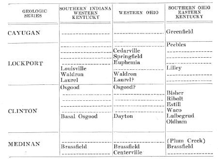
| Table of Silurian Strata of Kentucky, Indiana, and Ohio. |
 |
In consequence, the Devonian rests on successively younger Silurian formations in passing from the crest of the anticline either westward or eastward. Moreover, the outcrops of all the Silurian formations, where directly overlain by the Devonian, thin out toward the anticline. For instance, in Jefferson and Oldham counties, the Louisville limestone thins out eastward, and at Hanover, Indiana, the Devonian rests on the top of the Laurel limestone. This is due to a continuation of the eastward thinning of the Louisville, but at a more northern location. Evidently, the Cincinnati anticline existed already in times preceding the middle Devonian. In fact, the striking differences between the Silurian faunas east and west of the anticline suggests the presence of the latter already in Clinton times, and possibly, to a less prominent degree, in the Medinan.
Possibly, the direction of the crest of the Cincinnati anticline in early times did not coincide precisely with its crest at present. In the western part of Ripley County, and in the adjacent parts of Jennings and Decatur counties, in Indiana, the Brass field is missing, and the Osgood rests directly on the Richmond. According to Prof. Walter H. Bucher, the local uplift resulting in the formation of Jeptha Knob, in Shelby County, suggests a disturbance taking place after part of Brassfield time and before part of the Osgood. Possibly there is a connection between these dissimilar occurrences. In Nelson County, the Devonian limestone is absent in an area extending from Balltown southward to New Haven and Gethsemene, the Devonian black shale resting here directly on the Silurian, but the area of direct contact between the Devonian and Richmond lies farther eastward, extending from Loretta and Raywick to Stanford. Possibly the crest of the Cincinnati anticline shifted from points as far west as those mentioned in Indiana, eastward to its present location, with increasing age.
At any rate, beginning with Clinton, times, the Cincinnati anticline appears to have dominated the distribution of the Silurian faunas of Kentucky, separating those east of the anticline from those west. There is a possibility that this anticline existed already in Medinan times, and that the Brassfield fauna crossed the anticline in southern Ohio and invaded east-central Kentucky from the north.
BRASSFIELD FAUNA
Plates XVII, XVIII, XIX
The Brassfield limestone is the most widely distributed of those Silurian formations whose faunas invaded from the South. It occurs in Oklahoma, Arkansas, Alabama, Tennessee, Illinois, Indiana, Ohio, southern Ontario, and western New York. The Brassfield is the only Silurian fauna of southern invasion which in Ohio crosses from the western to the eastern side of the Cincinnati anticline, and which therefore is known in east-central Kentucky as well as in the west-central part of that State.
The close agreement between the Brassfield fauna in east-central
Kentucky with that in west-central Kentucky is shown in the following list, in
which the species found in east-central Kentucky as well as in west-central
Kentucky are printed with an asterisk (*), while those found so far only in
west-central Kentucky are printed without such a mark. It is probable that if
the Brassfield area in east-central Kentucky were subjected to the same careful
search as that employed in west-central Kentucky, little difference in their
faunas would be noted. Plectatrypa marginalia, Plectatrypa multistriata,
Autolichas clintonensis, Bellerophon exiguus, Bellerophon opertus, Bucania
fiscellostriata, *Calymene niagarensis, Camarotoechia convexa, *Camarotoecliia
scobina, *Chasmatopora angulata, *Clathrodictyon vesiculosum, *Clathropora
frondosa clintonensis, Crania dubia, *Dalmanella elegantula, Dalmanitina
pulchellus, *Diaphorostoma daytonense, Encrinurus thresheri, *Enterolasma
facetum, Enterolasma geometricum, Favosites favosus, Favosites niagarensis, *Hallopora
magnopora, Heliolites interstinctus, *Heliolites subtubulatus, Homotrypa*
confluens, Bumastus ambiguus, Illaenus daytonensis, *Leptaena rhomboidalis,
Lindstroemia gamesi, Orthis flabellites dinorthis, *0rthis flabellites euorthis,
Oxydiscus youngi, Pachydictya bifurcata, Pachydictya crassa, Phaenopora expansa,
Phaenopora multifida, *Platystrophia daytonensis, *Platystrophia reversata,
*Sowerbyella prolongatus, Pterinea brista, Ptilodictya expansa, *Ptychophyllum
ipomoea, *Rhinopora verrucosa, Rhipidomella hybrida, *Schuchertella daytonensis,
Stricklandinia triplesiana, *Strophonella daytonensis, *Strophonella,
hanoverensis, *Triplesia ortoni, *Zaphrentis daytonensis, *Zaphrentis obliquus.
Four species occurring in the Brassfield of east-central Kentucky, are known
also from Ohio, but not from west-central Kentucky; these four are Aspidopora
parmula, Calymene vogdesi, Hemitrypa ulrichi, and Orthis fissiplicata.
In general, the Brassfield is most fossiliferous farther northward, in Ohio and Indiana, and in the immediately adjacent parts of Kentucky; but farther southward in Kentucky, and in Tennessee, it is much less fossiliferous. This feature it shares with the Osgood and Laurel formations.
The Brassfield fauna is a relatively large one. It consists of 34 species of brachiopods, 27 bryozoans, 22 cephalopods, 17 gastropods, 14 trilobites, 13 corals, 9 pelecypods, 6 echinoderms (3 crinoids, 2 starfish, and 1 cystid), 2 hydrozoans, 2 graptolites, and 1 ostracod.
An interesting outlier of Brassfield limestone occurs 3 miles southwest of Mitchellsburg, in the western part of Boyle County, Kentucky. The top of this outcrop contains the large crinoid beads characteristic of the top of the Brassfield in eastern Kentucky. It contains also Stricklandinia triplesiana and Whitfieldella subquadrata. Another outlier is exposed in the northern edge of Wayne County, along the Cumberland River, at the mouths of Forbush and Little Cub Creeks. Here the top of the Brassfield limestone also contains the large crinoid beads and the Whitfieldella subquadrata. The clay shale overlying the horizon containing the large crinoid beads is regarded as the basal part of the Crab Orchard clay shale series. Evidently it is that phase of the Brassfield which is characteristic of east-central Kentucky which is present at the outliers here mentioned.
OSGOOD FAUNA
Plate XXIII
The Osgood formation can be traced from Fayette County, in
southeastern Indiana, to the western part of Nelson County, in west-central
Kentucky. It reappears in Sumner County, in north-central Tennessee and reaches
the southern part of that State, at Iron City. It is most fossiliferous in
Ripley County and in the adjacent part of Jefferson County, in Indiana,
especially in the vicinity of Osgood in the former county, and along Big Creek
in the latter.
In Jefferson County, Kentucky, the following species were found: Atrypa
reticularis, Calymene niagarensis, Camarotoechia whitii, Dalmanella elegantula,
Dawsonoceras americanum, Diaphorostoma niagarense, Dictyonella reticulata,
Enterolasma calyculum, Eucalyptocrinus cf. caelatus, Favosites cristatus,
Hallopora elegantula, Holocystites cf. parvulus, Leptaena rhomboidalis, Orthis
flabellites, Orthis interplicata, Pachydictya crassa, Sowerbyella transversalis,
Rhipidomella hybrida, Rhynchotreta cuneata americana, Schuchertella subplana,
Spirifer crispus, Spirifer niagarensis, Spirifer radiatus, Stephanocrinus
gemmiformis, and Striatopora flexuosa. Farther south, the fauna
becomes even more impoverished, as may be noticed in the list of species found
in the vicinity of Bardstown, after careful search: Atrypa reticularis,
Calymene niagarensis, Diaphorostoma niagarense, Leptaena rhomboidalis,
Schuchertella subplana, Spirifer crispus, and Spirifer radiatus.
Many species found farther north have dropped out, and no new ones have made
their appearance. In most of Tennessee, fossils are exceedingly rare in the
Osgood formation, with the exception of Pisocrinus gemmiformis and
Stephanocrinus osgoodensis. At Clifton, however, the following additional
species were found: Lechritrochoceras cinctutum, Diaphorostoma cliftonensis,
Hebertella tenax, Hyolithes cliftonensis and Platyceras pronum.
Considering the restricted area within which the Osgood formation is abundantly fossiliferous, the fauna is fairly large. It consists almost entirely, however, of echinoderms, bryozoans, and brachiopods, as may be seen from the following tabulation of species: 44 cystids, 9 crinoids, 31 bryozoans, 22 brachiopods, 6 corals, 4 gastropods, 3 trilobites, and 1 cephalopod.
The most striking feature of this Osgood fauna is the large
number of species of cystids present, most of which, namely 40 out of 44
species, belong to the single order Diplorita; in fact, 38 species were
described originally under the single generic name Holocystites. In a
similar manner, all of the species of crinoids, except Pisocrinus gemmiformis,
belong to the single genus Stephanocrinus. In other words, the Osgood
echinoderm fauna is rich in species but poor in genera.
Another striking feature is the large number of species of bryozoans occurring
both in the Osgood formation in Indiana and in the Rochester formation of New
York, 29 of the 31 species found in Indiana occurring also in New York. This
demonstrates the Rochester age of the Osgood formation. They apparently
represent local manifestations of the same widespread southern faunal invasions.
According to Ulrich, they form the top of the Clinton division of the Niagaran.
Since the Osgood represents a southern invasion, its fauna shows striking similarity with the Brassfield fauna beneath, and the Waldron fauna above, the latter also being southern invasions.
The nearest approach to the Osgood formation on the east side of the Cincinnati anticline appears to be the Bisher formation, but faunally this Bisher formation is related more closely to the Rochester of New York, Pennsylvania, and Maryland, than to the Osgood of Indiana. In other words, the fauna of the Bisher presents distinctly Atlantic elements. Among the few species occurring also in the Osgood formation of Indiana are Stephanocrinus gemmiformis, Stephanocrinus hammelli, isolated plates with diplopores apparently belonging to Holocystites, and a large species of Bumastus resembling Bumastus ioxus. In addition, Whitfieldella cylindrica of the Bisher formation is represented in the Osgood formation by a smaller form, more similar to the typical forms of this New York species. Spirifer niagarensis also appears common to the Bisher and Osgood.
LAUREL FAUNA
Plate XXIII
The Laurel limestone may be traced from Fayette County, Indiana,
to the southwestern part of Nelson County, in west-central Kentucky. It outcrops
again in Sumner County, in north-central Tennessee, and may be traced southward
as far as Wayne County, in the southern part of that state. At its type
locality, west of Laurel, Indiana, only the lower part of the Laurel limestone
is exposed, but between St. Paul and Dupont, in that state, there is a higher
horizon, 5 to 15 feet in thickness, which is much more fossiliferous.
Almost all fossils listed as coming from the Laurel limestone come from this
upper zone at St. Paul. From this one locality 61 species of echinoderms have
been described, including 56 crinoids, 4 cystids, and 1 blastoid. In addition
this upper horizon has furnished 7 species of brachiopods, 5 of cephalopods, 5
corals, 1 gastropod, 1 pelecypod, and 1 trilobite. In contrast with this upper
zone, the remainder of the Laurel limestone has furnished but few fossils. It is
not known from what horizons Trochurus byrnesanus and Trochurus
hanoverensis were obtained, but they are assumed to have come from beneath
that furnishing the numerous species listed from St. Paul. The basal parts of
the Laurel limestone have furnished, so far, only Pisocrinus gemmiformis,
Pisocrinus campana, Atrypa reticularis, Spirifer crispus, and Dalamanites
limulurus.
Southward, in Kentucky and Tennessee, fossils in the Laurel limestone are relatively rare. Charles Butts listed Striatopora gorbyi, Atrypa reticularis, and Dalmanella elegantula from the exposures in Jefferson County. In the western part of Nelson County, in the vicinity of Boston, the following species were found in the upper part of the Laurel formation: Atrypa reticularis, Calymene niagarensis, Camarotoechia whitii, Dalmanites limulurus, Dawsonoceras americanum, Diaphorostoma niagarense, Eucalyptocrinus crassus, Schuchertella subplana, Spirifer crispus, Stephanocrinus gemmiformis, and Uncinulus stricklandi. These fossils indicate merely that the fauna, as known from Kentucky, belongs to the Lockport division of the Niagaran strata.
Much more can be learned from the fauna of the upper part of the Laurel formation as exposed at St. Paul, Waldron, and Hartsville, Indiana, localities within 10 miles from each other. The crinoids, for instance, show a closer relationship to the Beech River division of the Brownsport formation than to the Racine of northern Illinois and southwestern Wisconsin. One third of the genera are represented also in the Silurian of Gotland and of England. Those occurring in both of the European countries include Callicrinus, Carpocrinus, Desmidocrinus, Gissocrinus, Mariacrinus, Marsipocrinus, Melocrinus, Myelodactylus, Pisocrinus, and Pycnosaccus. To this should be added Patelliocrinus and Petalocrinus, which in Europe are known only from Gotland. In the Waldron shale the following additional European genera make their appearance: Botryocrinus, Cyathacrinus, Dimerocrinus, Eucalyptocrinus, Ichthyocrinus, Lecanocrinus, and Lyriocrinus. The latter continue into the Racine, where the genera Corymbocrinus, Crotalocrinus, and Habrocrinus are added. In the Racine, 20 out of 36 echinoderm genera are known also from the Silurian of Gotland and England. This Racine fauna has an approximately east and west distribution, extending from eastern Iowa, northern Illinois, and southeastern Wisconsin, through northern Indiana and southern Ontario, to western Ohio and northwestern New York. It appears to be a northern fauna, possibly of north Atlantic origin, entering from some area farther east than Hudson Bay.
The upper Laurel fauna, as revealed at St. Paul, Indiana, also appears to be of northern distribution. It contains Petalocrmus and Goniophyllum, two Gotlandian genera known in this country only from the St. Paul area in Indiana, and from Jones and Dubuque Counties in eastern Iowa. Among the cephalopods found in the upper Laurel of Indiana, Elrodoceras indianense and Gigantoceras elrodi are represented at Joliet, Illinois, by closely similar, if not identical, forms. Moreover, Nautilus (?) oceanus appears to be related to the Gigantoceras group of cephalopods, though not congeneric with typical Gigantoceras. These cephalopods evidently belong to the same invasion as the Joliet, Waukesha, and Racine faunas.
WALDRON FAUNA
Plate XXIII
The Waldron shale may be traced from the southern part of Shelby
County, in Indiana, to Clifton, in the southern part of west Tennessee. It is
richly fossiliferous in the vicinity of Waldron, Hartsville, Vernon, and Dupont,
in Indiana, but south of Dupont the fossils become few or even scarce, not only
in Indiana, but also across Kentucky, and in the northern part of Tennessee. It
is very fossiliferous again in the vicinity of Newsom, Tennessee, and fairly
fossiliferous at Clinton and Iron City, but elsewhere in Tennessee it often is
relatively poor in fossils.
From Jefferson County, Kentucky, Charles Butts listed Atrypa reticularis,
Calymene breviceps, Camarotoechia acinus, Camarotoechia neglecta, Dalmanella
elegantula, Dictyonema sp., Pachydictya crassa, Rhynchotreta cuneata
americana, Spirifer crispus simplex, and Spirifer radiatus. From 3
miles east, of Bardstown, in Nelson County, the following were obtained:
Atrypa reticularis, Retzia evax, Spirifer eudora, and Whitfieldella
nitida.
The Waldron fauna includes 53 species of brachiopods, 49 bryozoans, 39 crinoids, 12 trilobites, 12 pelecypods, 12 gastropods, 8 cephalopods, 8 corals, 7 sponges, 4 ostracods, 3 worms, 2 so-called fucoids, 1 cystid, and 1 graptolite. The brachiopods, bryozoans, and crinoids together form two-thirds of the entire Waldron fauna. This fauna represents a southern invasion, as did the Brassfield and Osgood faunas.
A clay shale, resembling the Waldron shale, occurs in the gorge west of Cedarville, Ohio, and contains Atrypa reticularis newsomensis, Dalmanella elegantula, Dalmanites verrucosus, Dictyonella reticulata, Eucalyptocrinus crassus, Leptaena rhomboidalis, Sowerbyella transversalis, Schuchertella subplana, Spirifer radiatus, Streptelasma radicans, and Strophostylus cf. cyclostomus. This is a typical Waldron fauna, those species having an extended vertical range being represented by their Waldron forms. West of Cedarville, this Waldron shale is overlaid directly by the Springfield and Cedarville dolomites. Farther westward in Ohio these dolomites rest directly on strata apparently equivalent to the Laurel of Indiana.
JEPTHA KNOB FAUNA
Plate XXIII
In the chert fragments at the top of Jeptha Knob, in Shelby
County, Kentucky, the following species were found: Calymene cedarvillensis,
Camarotoechia indianensis, Cypricardinia jepthaensis, Dalmanella elegantula,
Dalmanella elegantula parva, Favosites favosus, Hallopora sp., Hormotoma
sublaxa, Illaenus daytonensis, Lophospira bucheri, Lyellia thebesensis,
Pachydictya cf. bifurcata, Platystrophia daytonensis, Rhipidomella hybrida,
Schuchertella cf. subplana, Strophonella milleri, Strophonella cf. hanoverensis,
and Trochonema sp.
According to Prof. Walter H. Bucher (Oil Shales of Kentucky, Kentucky Geol.
Survey, Series VI, vol. 21, pp. 209, 212, 215; 1925) the thickness of the
dolomitic limestone, between the fossil breccia containing Brassfield fossils
and the overlying chert containing the fauna listed above, is 90 feet.
Unfortunately no trace of the Waldron shale, at least in an identifiable form,
was discovered. Hence it is impossible to determine definitely whether the
fossils listed belong to the top of the Laurel or at the bottom of the
Louisville, especially in the absence of any information as to the fossil
content of the lower part of the Louisville limestone. However, the fauna listed
does not suggest Laurel age, and 90 feet exceeds any known interval between the
Brassfield and the base of the Louisville limestone in any area relatively near
to Jeptha Knob. Therefore, the reference of these fossils to the lower part of
the Louisville limestone, as done by Prof. Bucher, here is accepted.
LOUISVILLE FAUNA
Plates XXIV-XXVI
The Louisville limestone is typically developed in Jefferson and Oldham counties in west-central Kentucky. It may be traced southward, through Bullitt County, to the southwestern part of Nelson County, and it reappears in Sumner County, in north-central Tennessee. It is well exposed in Clark County, Indiana, and may be traced as far north as Shelby and Rush counties. It is most fossiliferous in Jefferson and Oldham counties in Kentucky and in the immediately adjacent parts of Indiana. Most of the fossils actually collected and described were obtained in the immediate vicinity of Louisville. These are listed by Charles Butts, in his Geology of Jefferson County, published in 1915 by the Kentucky Geological Survey. This list includes 110 species of corals, 60 brachiopods, 8 gastropods, 8 echinoderms (including 3 crinoids recently published by Frank Springer), 3 bryozoans, 3 hydrozoans, 2 sponges, 2 trilobites, 1 cephalopod, and 1 graptolite.
The corals occur chiefly in the upper 8 feet of the Louisville limestone, as exposed within the limits of Louisville. Thirty of the species of corals found at this horizon occur also in the Lobelville division of the Brownsport formation, as exposed in west-central Tennessee, and the two horizons are regarded as equivalent by Pate and Bassler (Proc. U. S. Nat. Mus., vol. 34, 1908, p. 424). Conchidium nysius and Pentamerus cylindricus occur at or immediately below this coral horizon, southeast of Charlestown, Indiana; Pentamerus oblongus and Astraeospongia meniscus were found 20 feet farther down. Possibly the strata immediately beneath the coral horizon correspond approximately to the Conchidiurn zone which forms the upper part of the Bob member of the Brownsport formation in west-central Tennessee. The few echinoderms known from the Louisville limestone suggest relationship with the Beech River member of the Brownsport formation as exposed in west-central Tennessee. Anisocrinus greenei, Macrostylocrinus meeki, and Troostocrinus reinwardt actually occur there. Caryocrinites kentuckiensis, Dimerocrinus halli and Gissocrinus lyoni are represented in west-central Tennessee only by congeneric species, and these are known only from the Beech River division of the Brownsport. Melocrinus oblongus occurs also in the Bob division of the Brownsport. Saccocrinus cuspidatus has relatives in the Laurel limestone of Indiana, but not, as far as known, in the Brownsport. These echinoderms suggest that the Louisville limestone is equivalent approximately to the Brownsport formation of Tennessee as a whole, rather than to its Lobelville division alone. However, in the absence of any definite knowledge of the character of the fauna in the lower and middle parts of the Louisville limestone, no definite correlation of these lower zones is possible.
In case the fauna of the Lilley formation, at Hillsboro, Ohio, should prove to be of upper Louisville age, the Cedarville fauna would definitely be established as of later age than the Louisville, but the relationship of this Lilley fauna still remains to be proved.
The lowest known formation of Niagaran age in northern Indiana is the Mississinewa shale. This contains an abundant graptolite fauna many species of which occur also in the lower Lockport of Hamilton, in Ontario. The cephalopods of the Listen Creek and Huntington formations suggest relationship with Racine and Cedarville faunas rather than with the Louisville. Apparently the Niagaran faunas of northern Indiana were derived from the same northern Atlantic source as the Lockport and Racine, while the Louisville and Brownsport formations are regarded as invasions from the south. Being invasions from different directions they are not likely to be contemporaneous and, unless found somewhere in contact, their relative age can only be surmised. The surmise here adopted is that the Louisville is older than the Cedarville, the latter being the Ohio phase of the Racine.
CENTERVILLE FAUNA
Plate XIX
Until recently, the Brassfield limestone was regarded as the oldest Silurian formation in the area traversed by the Cincinnati anticline. The term Belfast, proposed for an arenaceous limestone in Highland and Adams counties in Ohio, was dropped when it was learned that it could be traced laterally into limestone strata containing a typical Brassfield fauna. The Belfast is merely a local phase of the base of the Brassfield.
In Indiana, and Ohio the base of the Brassfield is underlaid by a clay shale, all of which, until recently, was referred to the Elkhorn member of the Richmond. Several years ago, however, a Silurian fauna was discovered locally in the uppermost part of this clay. At the quarry east of Centerville, for instance, the following fauna was found, in which the species printed with an asterisk (*) indicate distinctly Silurian relationship : Bellerophon centervillensis, *Brachyprion sp., Ctenodonta cf. simulatrix, *Dalmanites apparently of the *D. limulurus type, Hormotoma centervillensis, Hormontoma trilineata, Liospira (?) depressum, Lophospira centervillensis, Lophospira ehlersi, Loxoceras husseyi, *Schuchertella subplana brevior, Spyroceras microtextile, and * Whitfieldella cf. ovoides. At a similar horizon southwest of West Union, Ohio, Prof. W. H. Shideler found a small form of *Whitfieldella, a *Rhynchotreta resembling *R. thebesensis, and a Hormotoma resembling H. trilineata. Such an association of fossils having a Silurian aspect with others having an Ordovician aspect is known also in the Edgewood formation of southwestern Illinois and in the adjacent part of Missouri. Hence the Ohio faunules here mentioned are correlated provisionally with the Edgewood, although no species known to be diagnostic of the Edgewood have been found. However, the presence of Platymerella manniensis at the base of the Brassfield, at Lawshe, in Adams County, appears to confirm such a correlation. Provisionally the term Centerville formation is proposed for the supposed Ohio equivalent of the Edgewood.
The presence of a possible Edgewood horizon at West Union, Ohio is of interest in the present connection since this locality is only 6 miles from the northern margin of Kentucky. It is needless to remark that the Richmond age of the typical Elkhorn clay shale is not affected by these discoveries.
DAYTON FAUNA
Plate XIX
The Dayton limestone is exposed typically at Dayton, Ohio. Southward it ranges as far as Ribolt, in Lewis County, Kentucky, and westward it almost reaches Richmond, Indiana. It has been correlated provisionally with the relatively thin limestone at the base of the Osgood formation in southern Indiana, but the latter is practically unfossiliferous, so that exact correlation is impossible.
At Ribolt, the Dayton limestone contains Calostylis cf. spongiosa, Clathrodictyon vesiculosum, Ptychophyllum riboltense, and Zaphrentis cf. intertexta. In Adams, Highland, and Clinton counties, in southern Ohio, the following additional species are found: Alveolites sp., Camarotoechia neglecta, Coenites sp., Cyathophyllum sp., Discosorus cf. conoideus, Drymopora sp., Euomphalopterus sp., Favosites cf. niagarensis, Gypidula sp., Halysites catenularia, Heliolites sp., Homoeospira sp., Illaenus cf. daytonensis, Lyellia sp., Orthis flabellites, Pentamerus cf. oblongus, Platystrophia reversata, Rhinopora verrucosa, Rhipidomella hybrida, Spirifer niagarensis, Strombodes mammilaris wilmingtonensis, Syringolites sp., and Whitfieldella cf. nitida. In the vicinity of Dayton, Ohio, the following species are added: Chasmatopora angulata, Clidochirus ulrichi, Coelospira sp., Enterolasma calyculum, Favosites favosus, Leptaena rhomboidalis, several species of Orthoceras, and Platystrophia daytonensis. In the vicinity of Eaton, Ohio, the following species are added: Atrypa reticularis, Sowerbyella transversalis, and Spirifer radiatus. The total Dayton limestone fauna therefore includes 15 species of corals and 15 of brachiopods, with 1 or 2 species of hydrozoans, bryozoans, crinoids, gastropods, and trilobites, and also several cephalopods.
The chief interest in the Dayton limestone consists, however, in the presence of a species of Pentamerus which resembles the form found at the mill on Second Creek, near Sodus Bay, north of Alton, New York. The Dayton limestone evidently is of Lower Clinton age, and provisionally is correlated with the Walcott limestone, at the top of the Lower Clinton.
OLDHAM FAUNA
Plate XIX
In east-central Kentucky, the typical Brassfield limestone it overlaid in ascending order by the Plum Creek clay, Oldham limestone, Lulbegrud clay, Waco limestone, and Estill clay. The typical Plum creek clay is not fossiliferous, but it's sparsely fossiliferous northern extension appears to be more nearly related to the preceding Brassfield than to the following limestone.
The typical exposures of the Oldham limestone lie along the railroad between Panola and Brassfield in the southern margin of Madison County. In the eastern parts of Madison and Clark counties, the top of this limestone is characterized by relatively numerous specimens of Stricklandinia norwoodi. Three miles southwest of Clay City, in the western part of Powell County, this Stricklandinia is associated with Dalmanella elegantula, Enterolasma calyculum, Halysites catenularia, Leptaena rhomboidalis, Platystrophia daytonensis, and Strophonella cf. patenta. A quarter of a mile south of Indian Fields, near the southwestern margin of Clark County, Heliolites subtubulata and a Zaphrentis similar to one in the Dayton limestone are added to this list.
A much larger fauna occurs at the Rose Run mine, about 4 miles east of Owingsville, in Bath County, Kentucky. Here a limestone, assumed to be equivalent to the Oldham limestone, though no Stricklandinia is present, contains: Alveolites sp, Atrypa reticularis, Calostylis cf. spongiosa, Calymene niagarensis, Camarotoechia whitii, Chonetes sp., Clathropora frondosa, Hallopora sp., Helopora sp., Phacops sp., Rhinopora verrucosa, Strophonella cf. patenta, Syringolites sp., and Zygobolba rectangula. Among these, the Zygobolba rectangula Ulrich and Bassler (Silurian, Maryland Geological Survey, 1923, pp. 372, 560) is characteristic of the middle part of the Lower Clinton. The type specimens are from the upper part of the Gun River formation on Anticosti, and additional specimens occur in the purple shale above the Pentamerus oblongus zone in the Reynales limestone; at Cumberland, Maryland, 60 feet above the base of the Clinton; and at Hagans, Virginia, in the purple shale and iron ore of the lower Clinton. The Calostylis also is indicative of Clinton age, occurring both in the Dayton limestone and in the Waco formation.
WACO FAUNA
Plate XX
The Waco limestone is exposed at numerous localities in the eastern part of Madison and Clark counties, in east-central Kentucky, but cannot be identified farther north. It consists of a moderate number of magnesian limestone layers inter-bedded with a greater quantity of clay, abundantly fossiliferous. One of these limestone layers locally attains a thickness of 1 to 2 feet, but the remaining layers usually are thin-bedded. It contains the following fauna:
Atrypa reticularis, Brachyprion cf. profundus, Bumastus cf.
imperator, Calostylis spongiosa, Calymene niagarensis, Chonophyllum solitarium,
Corynotrypa dissimilis, Cyathophyllum densiseptatum, Cyathophyllum sedentarium,
Cystiphyllum spinulosum, Dalmanella elegantula, Diaphorostoma niagarensis,
Encrinurus ornatus, Favosites declinatus, Favosites gothlandicus, Favosites
hisingeri aplatus, Halysites catenularia, Hebertella sp., Heliolites
spongiosa, Heliolites subtubulata, Isochilina panolensis, Lindstroemia
lingulifera, Lyellia eminula, Meekopora bassleri, Orthis flabellites,
Parastrophia sp., Pholidops ovalis, Platystrophta reversata, Polyorophe
radicula, Strombodes granulosus, Strombodes mammilaris distans, Strophonella cf.
tenuistriata, Strophostylus cf. cancellatus, Syringolites huronensis, Zaphrentis
charaxata, and Zaphrentis intertexta.
This fauna consists of 19 species of corals, 9 brachiopods, 2 bryozoans (others
not identified), 3 trilobites, 2 gastropods, and 1 ostracod. It is regarded
provisionally as of early upper Clinton age, chiefly on account of the presence
of Meekopora bassleri, since that species, or one closely similar, is
stated by Ulrich and Bassler to occur in strata containing a Rochester fauna at
Clinton, New York. Syringolites huronensis is cited by Prof. M. Y.
Williams from the Lockport of Manitoulin Island, in Ontario; Calostylis
and Polyorophe are genera originally described from the Silurian of
Gotland; but no correlation can be based on these corals. Provisionally, the
Waco fauna is regarded as a southern invasion.
RIBOLT FAUNA
Plate XXI
The clay shale which overlies the Waco limestone has been called the Estill clay. Its typical exposure is about a mile north of Irvine, along a road ascending a hill south of White Oak Creek. Here the Estill clay is 56 feet thick and is overlaid directly by Devonian limestone.
In Lewis County, Kentucky, no trace of the Waco limestone can be identified. Here a clay shale, at least 100 feet thick, directly overlies the Dayton limestone. At Peebles,, Ohio, it is 85 feet thick; at Hillsboro, Ohio, it is 75 feet thick. At all of the three localities named, the upper part of the clay shale is interbedded with thin indurated layers, often only a quarter of an inch thick, which are characterized by a distinctively Clinton fauna.
In the western part of Lewis County, Kentucky, the following species have been identified: Anoplotheca cf. obsolete, Brachyprion mundula, Bucaniella cf. trilobata, Camarotoechia congruens, Camarotoechia neglecta, Chonetes vetustus, Dalmanites clintonensis, and Liocalymene clintoni. Associated with the latter were the following ostracods: Mastigobolbina typus, M. triplicata, M. trilobata, M. glabra, Plethobolbina sp., and Zygosella vallata.
One-half mile west of Peebles, Ohio, the following additional species appear: Pterinea emacerata, Schuchertella cf. subplana, Mastigobolbina arguta, M. modesta, M. punctata, and Plethobolbina typicalis. One and one-half miles north of Elmville, in the southeastern part of Highland County, the following additional species are found: Atrypa reticularis, Brachyprion cf. planus, Calymene niagarensis, Gyronema sp., Leptaena rhomboidalis, Pholidops squamiformis, Schuchertella cf. prosseri, and Spirifer radiatus. Near Jacksonville, south of Peebles, Ohio, a species occurs which closely resembles Sowerbyella tennesseensis in size and in the number and elevation of the more prominent, striae.
The ostracods of the preceding lists are characteristic of the middle part of the upper Clinton of New York, Pennsylvania, Maryland and Virginia (Ulrich and Bassler, in the volume on the Silurian, Maryland Geol. Survey, 1923, p. 377).
That part of the clay shale section which includes the indurated layers containing this middle-upper Clinton fauna is here named the Ribolt shale, to distinguish it from the underlying Estill shale, which is not known to be fossiliferous.
BISHER FAUNA
Plate XXI
The Bisher formation is typically exposed along the eastern margin of Hillsboro,, Ohio. It may be traced southward as far as Lewis County, Kentucky, where the following fauna is found at Martin's Store, 3 miles southwest of Carr's station: Brachyprion planus, Calymene niagarensis, Camarotoechia pisa, Camarotoechia subrhomboidalis, Dalmanites brevicaudatus, Diaphorostoma cf. cliftonense, Homolanotus delphinocephalus, Bumastus cf. depressus, Leptaena rhomboidalis, Schuchertella confertus, and Spirifer radiatus. At Harin Hill, 4 or 5 miles southwest of Martins store, the following additional species are found: Dalmanella elegantula, Spirifer harinensis, Spirifer nanus, and Spirifer repertus. At Glen Springs, 4 or 5 miles south of Harin Hill, the following were obtained: Atrypa cf. rugosa, Clathropora frondosa, Cornulites clintoni, Rhipidomella magnicardinalis, Rhynchotreta americana, Spirifer radiatus obsoletus, and Whitfieldella cf. cylindrica.
Among other species found in the Bisher formation in southern Ohio are: Atrypa elongata, Bumastus ioxus, Camarotoechia neglecta, Camarotoechia roadsi, Chasmatopora angulata, Cheirurus niagarensis, Cyphaspis sp., Cyrtia myrtia, Diaphorostoma niagarensis, Encrinurus sp., Pholidops subelliptica, Platyceras angulatum, Platystrophia pauciplicata, Sowerbyella transversalis, Rhipidomella hybrida, Schuchertella prosseri, and Spirifer eudora.
From the Crooked Creek quarry, four and one-half miles south of Sinking Spring,, in the northern part of Adams County, Ohio, the following ostracods were identified by Ulrich and Bassler: Dizygopleura asymmetrica, D. lacunosa, D. loculosa, D. symmetrica, Paraechmina spinosa, and Primitiella aequilateralis. These species are characteristic of the upper part of the upper Clinton as exposed in Juniata County, in central Pennsylvania. This is the only part of the Clinton of Pennsylvania and Maryland correlated by Ulrich and Bassler with the Rochester of New York. Hence, the Bisher formation of Ohio and Kentucky also is regarded as of Rochester age. In Kentucky, this formation has not been traced farther south than Plummer's Mill, in the eastern part of Fleming County.
LILLEY FAUNA
Plate XXII
The Lilley formation is exposed typically along the eastern
margin of Hillsboro, Ohio, and there are traces of this formation also several
miles southeast of Marshall and immediately north of Crooked Creek about four
and a half miles south of Sinking Spring. At Hillsboro, this formation contains
the following fauna: Acervularia paveyi, Anastrophia internascens, Atrypa
reticularis hillsboroensis, Brachyprion newsomensis, Calymene cf. vogdesi,
Camarotoechia indianensis, Camarotoechia neglecta, Coenites verticillatus,
Cyathophyllum roadsi, Dalmanites brevigladiolus, Diaphorostoma hillsboroensis,
Encrinurus cf. ornatus, Halysites labyrinthicus, Holophragma calceoloides,
Leptaena rhomboidalis, Plasmopora follis, Poleumita paveyi, Poleumita prosseri,
Proetus collinodosus, Rhipidomella hybrida, Rhynchotreta cuneata americana, a
stromatoporoid, Strombodes striatus, Trochonema fatuum, Zaphrentis digoniata.
At Crooked Creek, the following species are added to this list: Cyathophyllum
radicula, Cystiphyllum niagarense, Favosites spinigerus, Heliolites subtubulatus,
Omphyma cf. verrucosa, and Striatopora cf. flexuosa.
The chief interest in this Lilley horizon is the presence of corals suggesting a
Louisville or Lockport age; these include Coenites verticillatus,
Cystiphyllum niagarense, Omphyma verrucosa, Plasmopora follis, and
Strombodes striatus. This coral zone, moreover, lies directly beneath the
Peebles formation, the latter correlating most readily with the Guelph of Canada
and adjacent New York, and less readily with the Cedarville of Ohio.
Two species of corals found in the Lilley formation are of special interest. One of these is Holophragma calceoloides, a species occurring also in Gotland. The other is Zaphrentis digoniata, which cannot be distinguished from specimens less abundantly represented in the upper third of the quarry at, Cedarville, Ohio. The presence of the Gotlandian genus Calostylis in the Waco formation of east-central Kentucky has been noted already. Possibly the Waco and Lilley faunas invaded east-central Kentucky from the same direction, presumably from the south, but along the eastern shore of the Mississippi embayment.
PEEBLES FAUNA
Plate XXII
The Peebles formation is exposed typically at Peebles, Ohio. It includes at this locality that part of the Niagaran which intervenes between the top of the Bisher west of town and the base of the Greenfield 2 or 3 miles eastward. At Hillsboro, the Lilley formation intervenes between the Bisher and the Peebles.
At Hillsboro, Pentamerus oblongus is abundant at the base of the Peebles formation. The general character of the fauna of this formation, as exhibited in Highland and Adams counties is shown by the following list: Amphicyrtoceras cf. pettiti, Amphicyrtoceras tantalum, Coelocaulus macrospira, Dinobolus conradi, Eccyliomphalus circinatus, Eotomaria areyi, Eotomaria halei, Goniophora crassa, Hormatoma whiteavesi, Megalomus canadensis, Monomorella sp., Pentamerus oblongus, Poleumita crenulata, Poleumita scamnata, Pycnostylus guelphensis, Straparollus paveyi, a globose stromatoporoid, Trimerella acuminata and Trimerella grandis. This is a Guelph fauna, comparable to that exposed in the southern part of Ontario and western New York. It differs distinctly from the Cedarville as exposed in Clinton, Greene, Clark, Montgomery, Miami, Peebles and Darke counties, in western Ohio. The Cedarville fauna is more like that of the Racine as exposed in Wisconsin and northern Illinois.
The Peebles formation can be traced southward as far as the Ohio River, in Adams county, where Trimerella acuminata and other characteristic Guelph fossils occur on the hills facing the river. Evidently, the strata overlying the Bisher formation in that part of Lewis County, Kentucky, which lies west of Vanceburg is to be correlated with the Peebles, though the species found so far are not strictly diagnostic of this horizon: Anastrophia internascens, Atrypa reticularis, Camarotoechia indianensis, Favosites niagarensis, Halysites labyrinthicus, Rhynchotreta cuneata americana, Spirifer cf. niagarensis, and Straparollus paveyi. The species named last was found at Clarksburg, west of Vanceburg. The Peebles formation is not exposed south of Lewis County.
GREENFIELD FAUNA
Plate XXII
The Greenfield dolomite is exposed typically at Greenfield, in the northeastern corner of Highland County. Exposures are fairly continuous, at the proper horizon, as far south as the middle of Adams County. However, in the southern half of Adams County, the Greenfield dolomite often is absent between the top of the Peebles formation and the base of the Ohio black shale.
The only exposure of the Greenfield dolomite known in Kentucky is exposed along the bank of the Ohio River, at Vanceburg, Ohio. Here, the ostracod typical of this dolomite, namely Leperditia ohioensis, is fairly abundant in certain layers.
From Greenfield, Ohio, the following fauna has been described:
Camarotoechia hydraulica, Hindella? (Greenfieldia) rostralis,
Hindella? (Greenfieldia) whitfieldi, Leperditia angulifera,
Leperditia ohioensis, Rhynchospira praeformosa, Schuchertella hydraulica,
Whitfieldella rotundata, and Whitfieldella subsulcata. To this list
should be added Pentamerus pesovis, described from some unknown locality
in Adams County. Ohio.
According to Ulrich and Bassler, the Greenfield dolomite belongs somewhere near
the base of the upper half of the Cayugan division of the Silurian. It has been
identified by Grabau in southern Michigan and the adjacent part of Ontario. Its
nearest relatives are to be found in New York, Pennsylvania, and thence
southward along the Appalachian Valley. This suggests invasion from some
Atlantic source.
BIBLIOGRAPHY
Davis, William J., Kentucky fossil corals. Kentucky Geological
Survey (1885). Louisville corals.
Foerste, August F., Fossils of the Clinton group in Ohio and Indiana. Ohio
Geological Survey, vol. 7 (1893). Brassfield fossils.
Foerste, August F., The Ordovician-Silurian contact in the Ripley island area of
southern Indiana. American Journal of Science, vol. 18 (1904).
Foerste, August F., The Silurian, Devonian and Irvine formations of east-central
Kentucky. Kentucky Geological Survey, Bull. 7 (1906).
Foerste, August F., Silurian Fossils from Ohio. Ohio Journal of Science, vol. 17
(1917), vol. 19 (1919). Bisher, Lilley, and other Silurian fossils.
Foerste, Aug. F., Notes on Medinan, Niagaran, and Chester Fossils. Denison
University Bulletin, vol. 20 (1923). Centerville and Jeptha Knob fossils.
Hall, James, Description of fossils in Niagara group at Waldron, Indiana.
Indiana Dept. Geology, 11th Annual Report (1881).
Hall, James, and Whitfield, R. P., Descriptions of Silurian fossils. Ohio
Geological Survey, Paleontology, vol. 2 (1875). Brassfield and Cedarville
fossils.
Meek, F. B., Descriptions of Invertebrate Fossils of the Silurian and Devonian
system. Ohio Geological Survey, Paleontology, vol. 1 (1873). Brassfield,
Cedarville, and other Silurian fossils.
Miller, Samuel A., Palaeontology. Geological Survey of Indiana, 17th and 18th
Annual Reports (1892, 1894) Osgood and Laurel Fossils.
Nettelroth, Henry, Kentucky Fossil Shells. Kentucky Geological Survey (1885).
Louisville brachiopods.
|
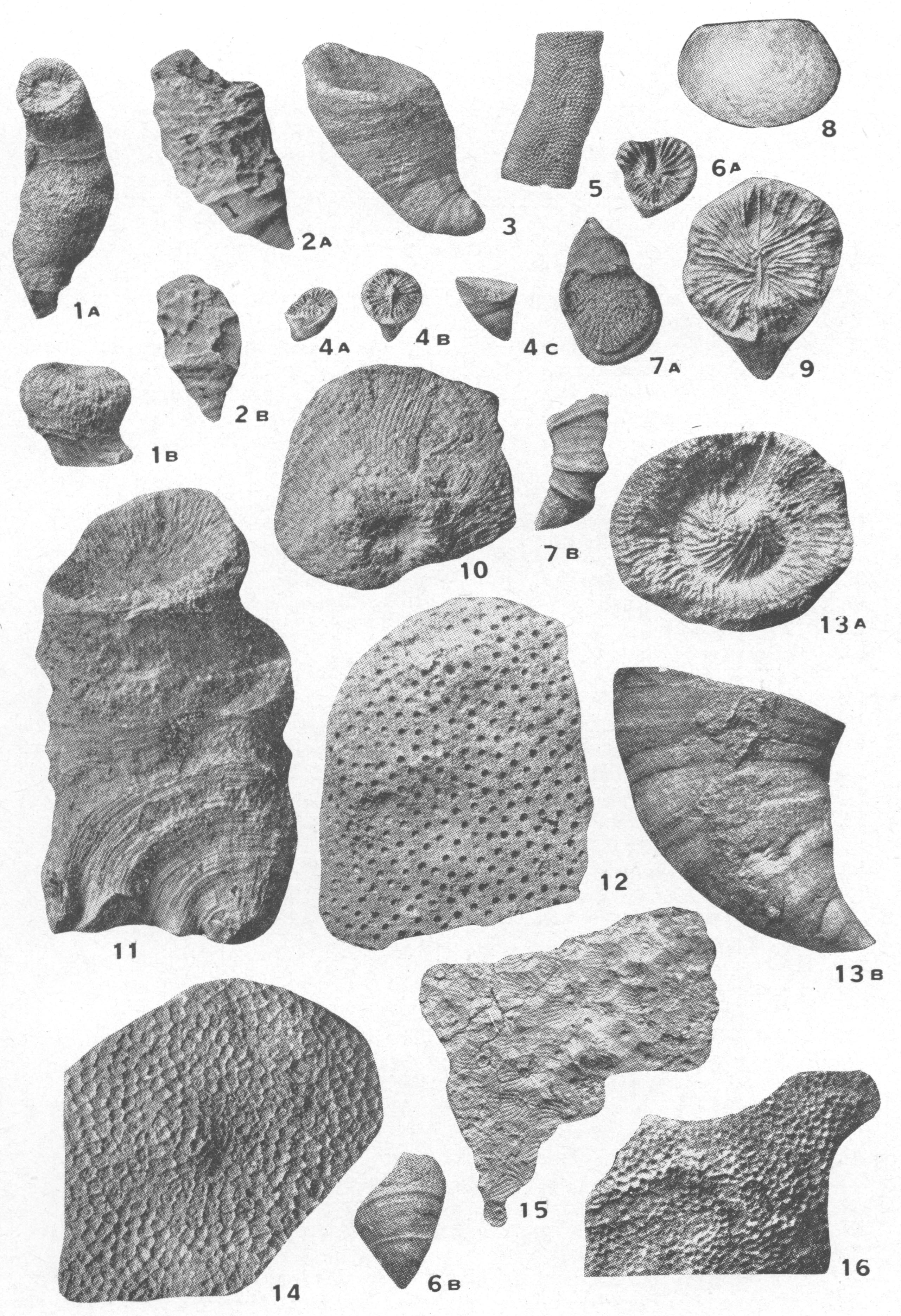
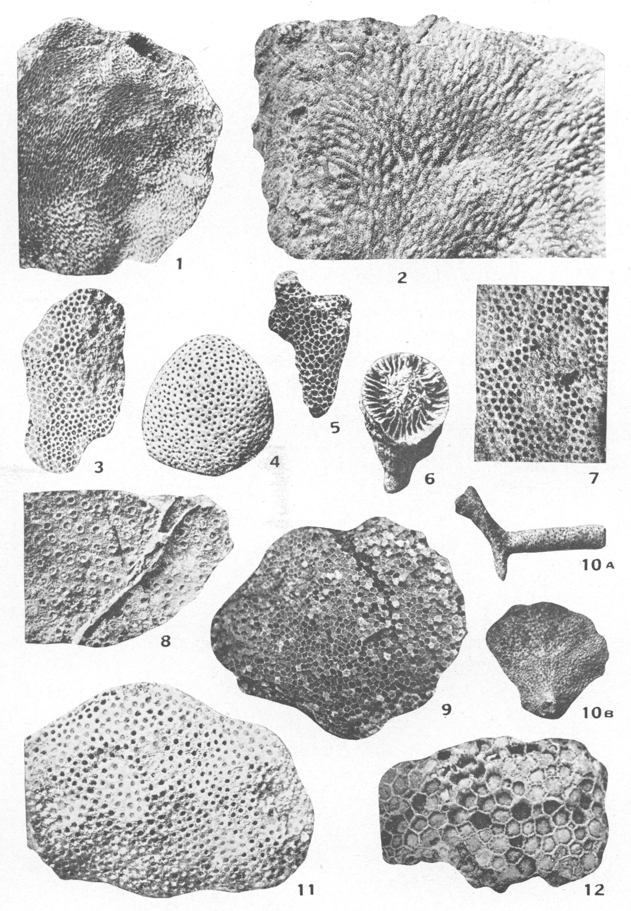
Explanation of Plate XVII BRASSFIELD FOSSILS |
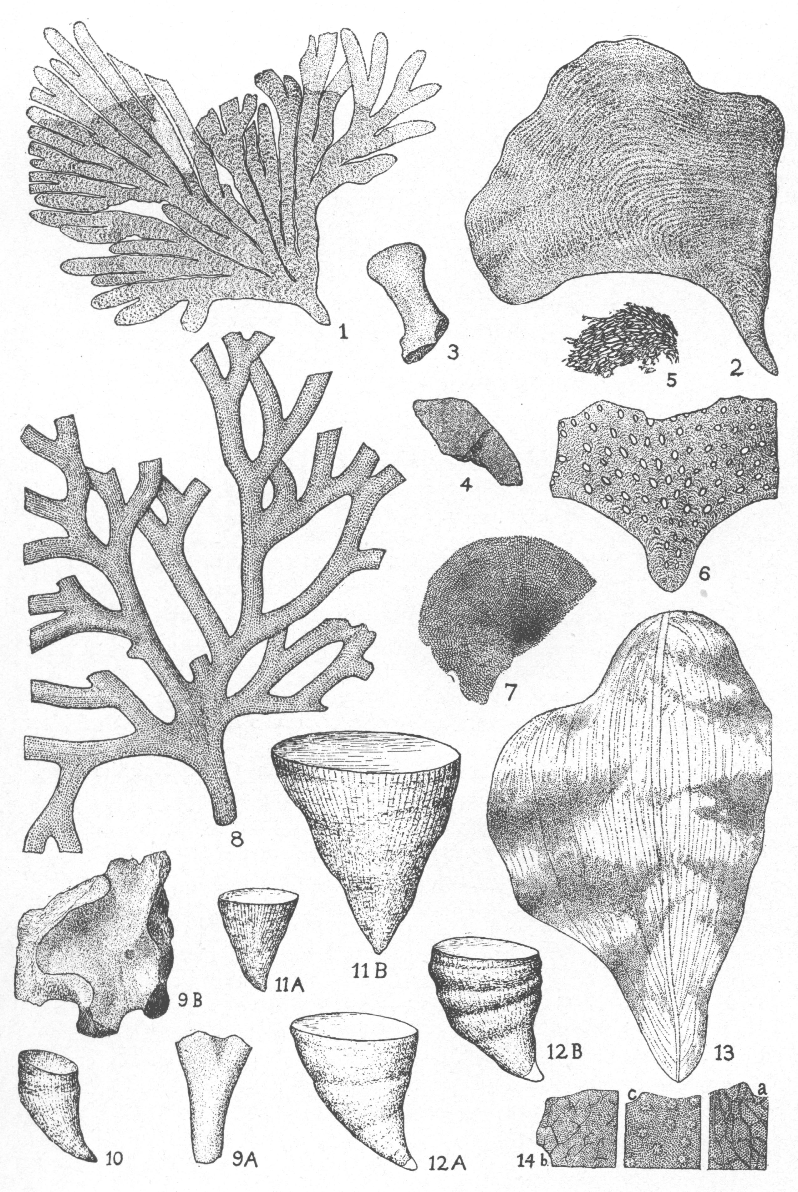 |
|
Explanation of Plate XVIII BRASSFIELD FOSSILS |
 |
|
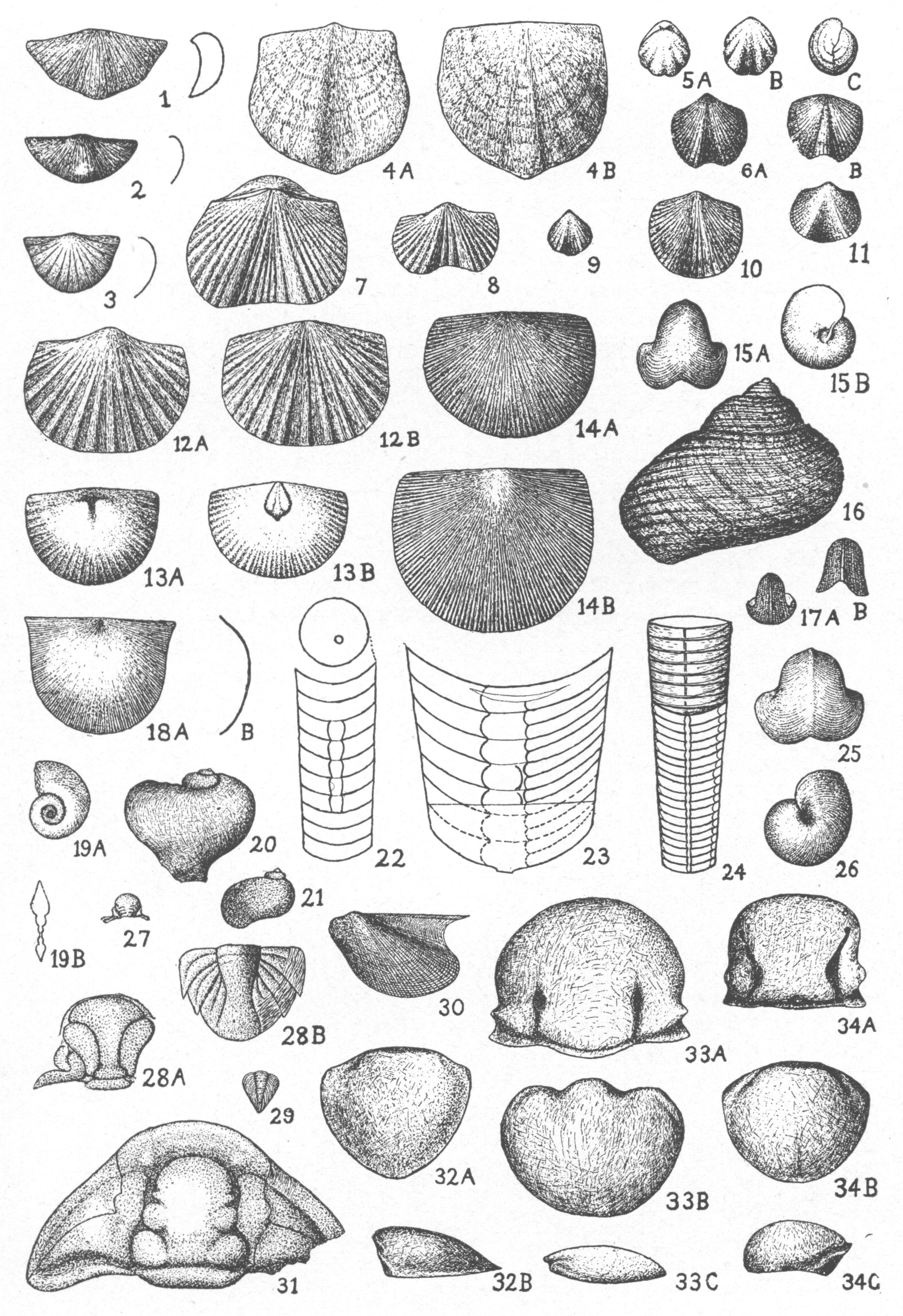
Explanation of Plate XIX BRASSFIELD FOSSILS |
 |
|
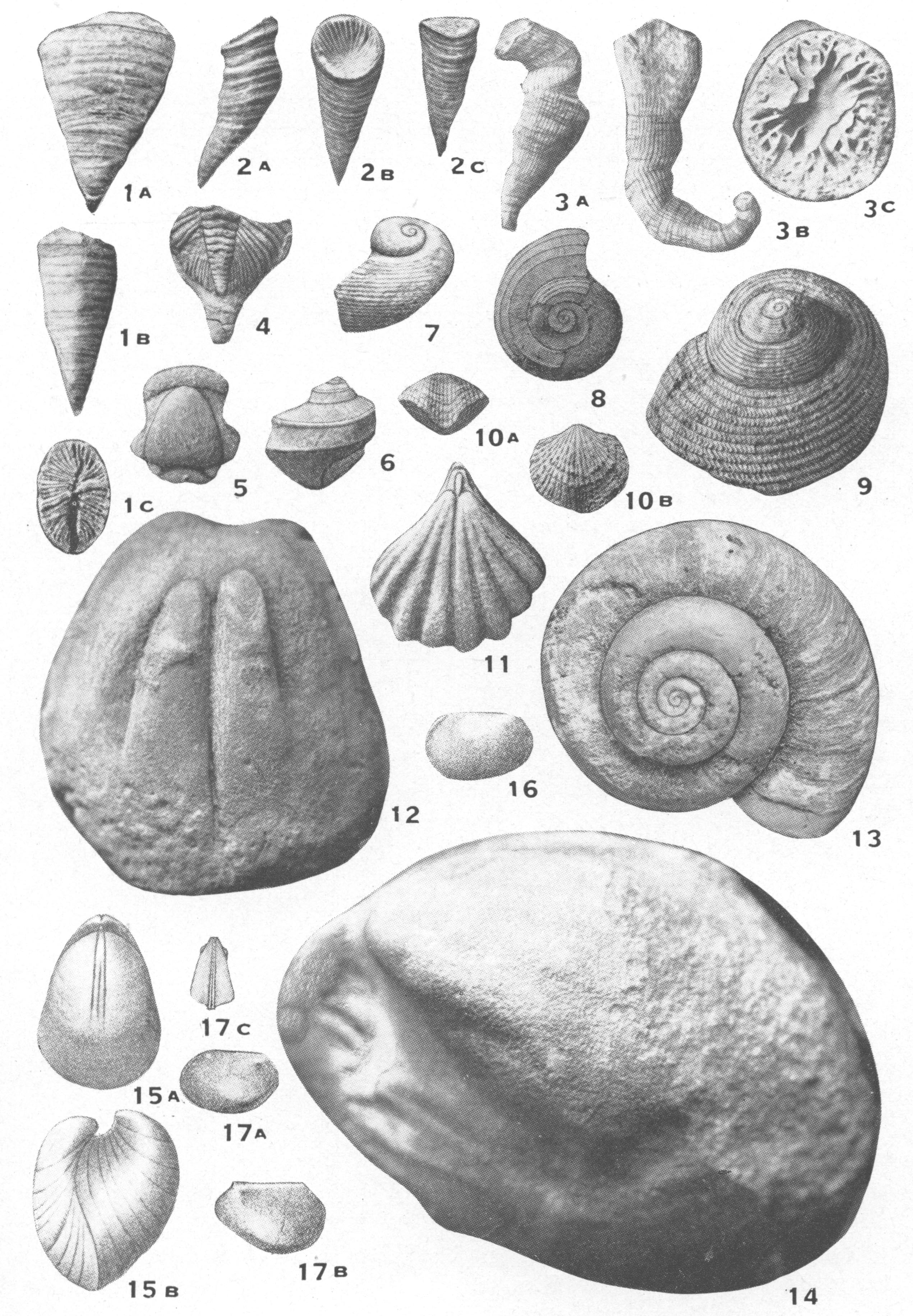
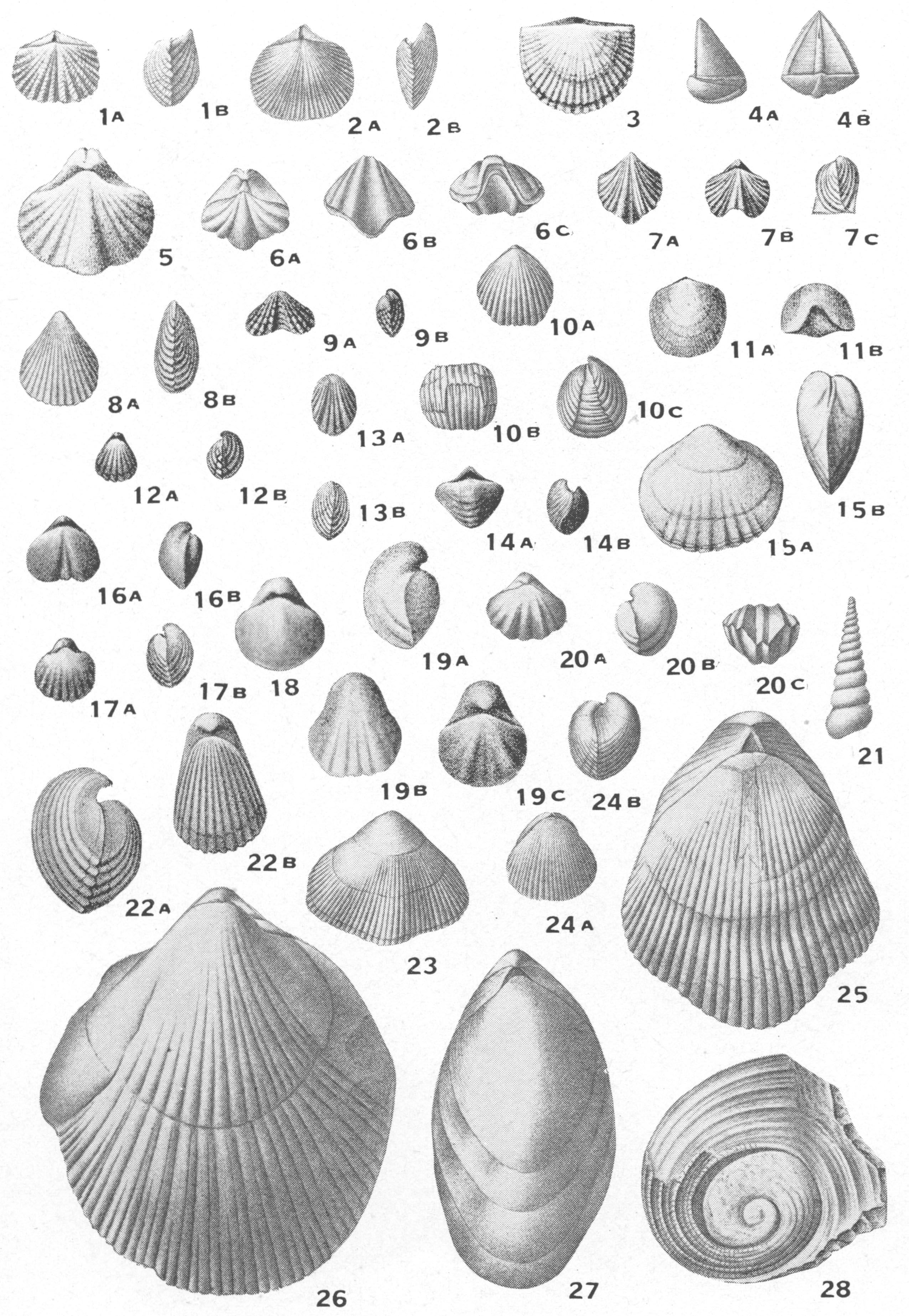
Explanation of Plate XX WACO FOSSILS |
 |
|
Explanation of Plate XXI RIBOLT FOSSILS |
 |
|
Explanation of Plate XXII LILLEY FOSSILS |
 |
|
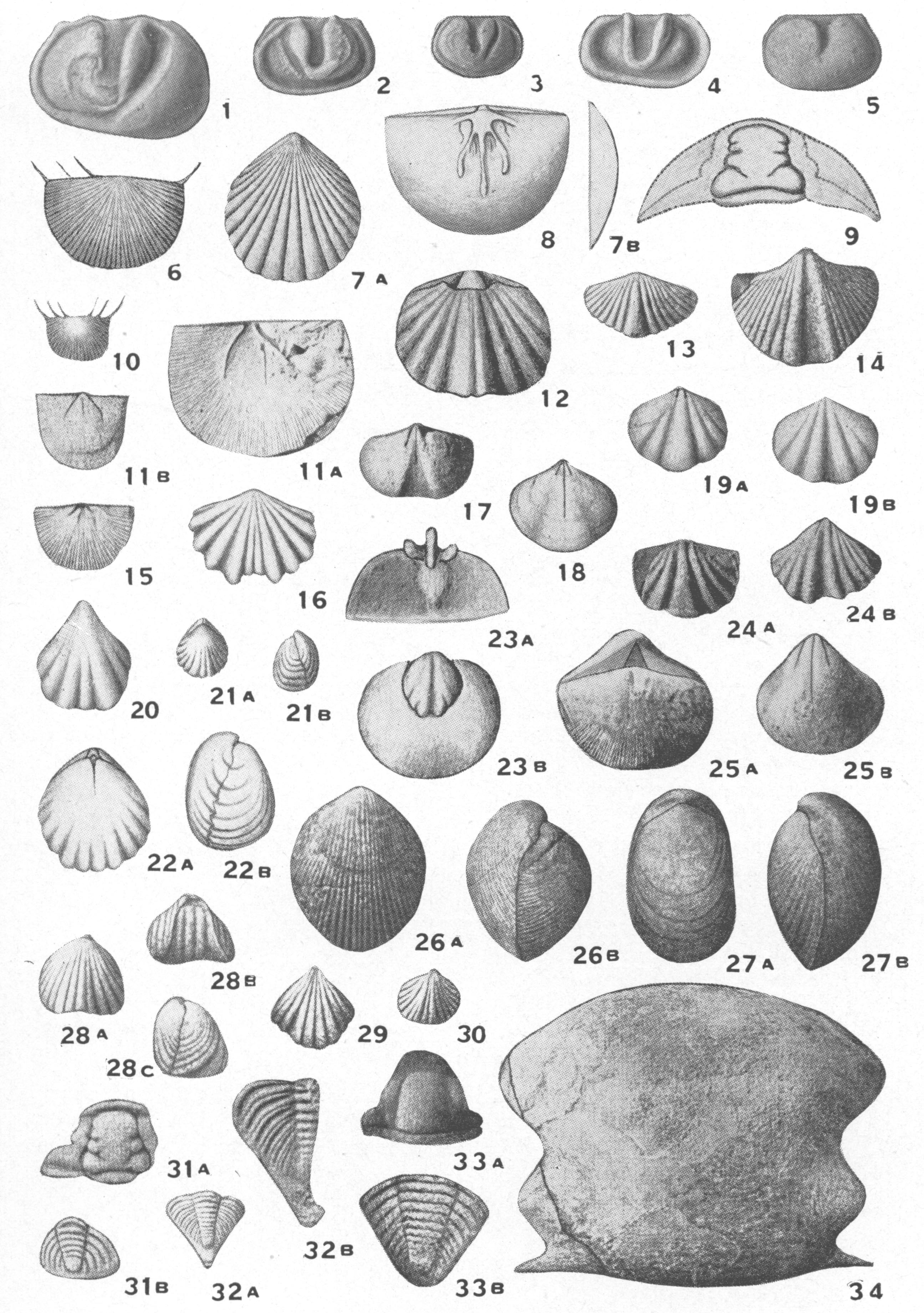
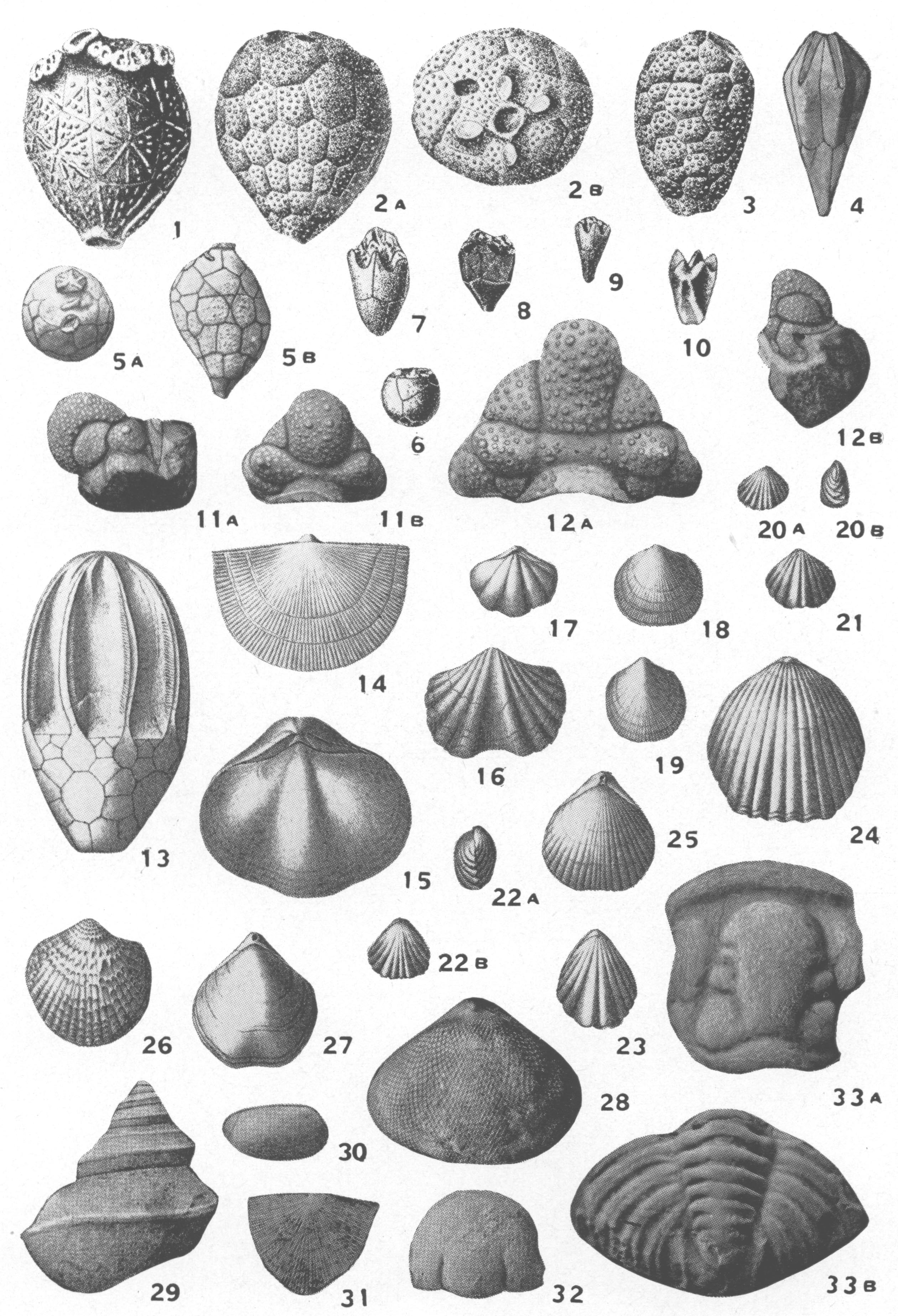
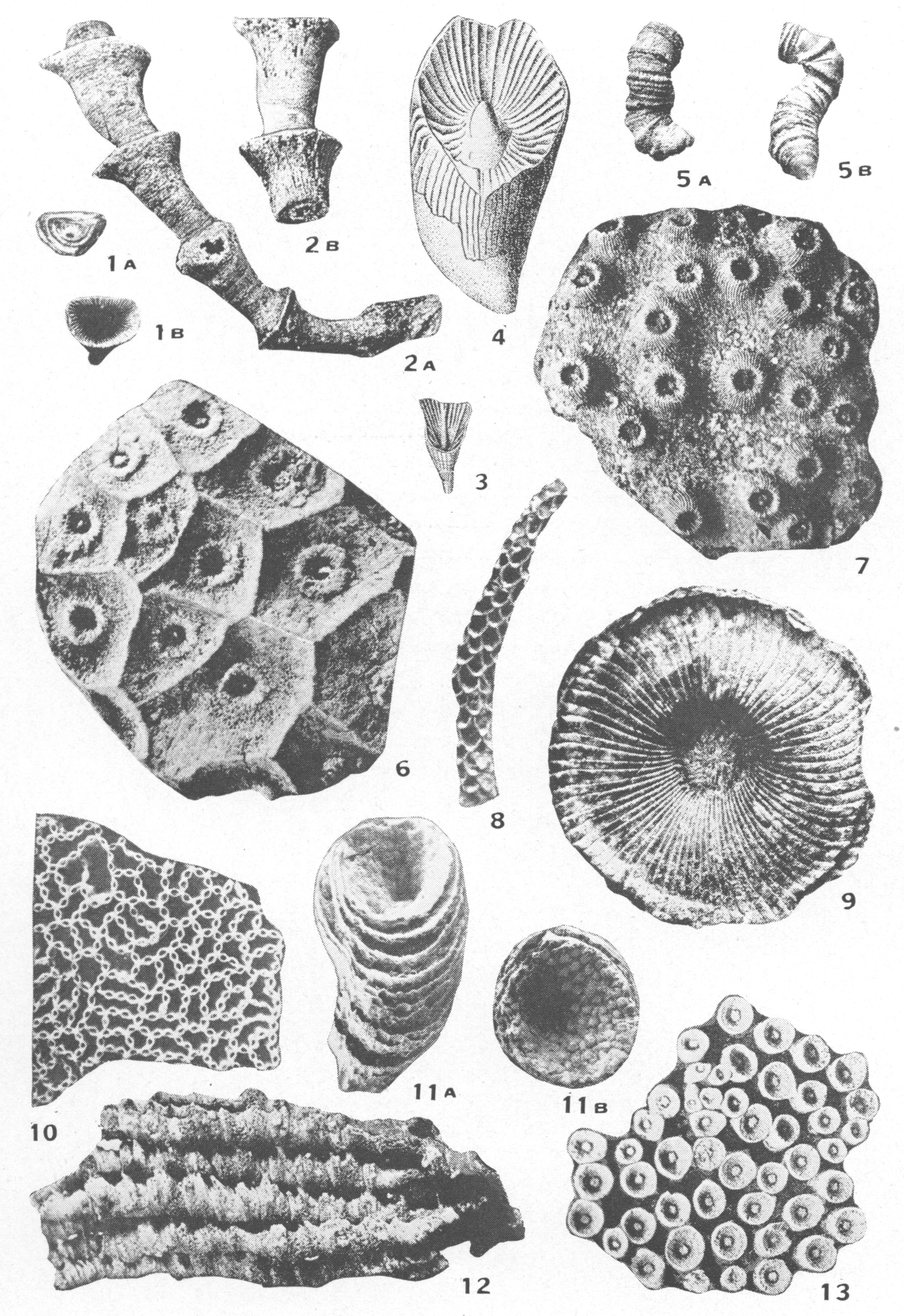
Explanation of Plate XXIII OSGOOD FOSSILS |
 |
|
Explanation of Plate XXIV LOUISVILLE FOSSILS FROM LOUISVILLE, KENTUCKY. |
 |
|
Explanation of Plate XXV LOUISVILLE FOSSILS FROM LOUISVILLE, KENTUCKY. |
 |
|
Explanation of Plate XXVI LOUISVILLE FOSSILS FROM LOUISVILLE, KENTUCKY. |
 |