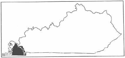
Fig. 32. Map of Kentucky showing outcrop of Cenozoic rocks.
By
JOSEPH K. ROBERTS
The Cenozoic era is represented in Kentucky by sediments of the Tertiary and Quaternary, but the sequence is not complete. Almost all of the sediments are limited to the Jackson Purchase area, that is, the region lying between the Tennessee and Mississippi Rivers, bounded on the north by the Ohio River and on the south by the State of Tennessee, though there are some deposits of sand, gravel, and loam between the Tennessee and Cumberland Rivers and to the east of the latter river. By far the greater portion of these sediments are unconsolidated, and like the Upper Cretaceous beds, they are not intruded by any forms of igneous rocks.
|
|
|
Fig. 32. Map of Kentucky showing outcrop of Cenozoic rocks. |
The Tertiary sediments lie unconformably upon the Upper Cretaceous and from a
standpoint of origin they represent marine, near shore, partly inland, and
continental deposits. The Tertiary deposits cover much more territory than the
Cretaceous. The time represented by the unconformity at the base of the Tertiary
is of great length, as indicated by the changes in flora below and above the
Cretaceous-Eocene contact shown in portions of the embayment area farther south
in
Tennessee, Alabama, and Mississippi. Only a few floras survived this interval,
and as the faunal record of the Tertiary is relatively nothing, little can be
said of any faunal changes. The Tertiary beds become progressively younger
towards the Mississippi River, and dip at a very low angle to the west in the
southern part of the State, to the southwest near the middle, and almost south
in the northern and northwestern portions. The structure is that of a gentle
monocline. The Eocene beds are mostly covered by a blanket of sand and gravel of
Plio-Pleistocene age, the so-called "Lafayette formation," and the Eocene
members are only exposed in clay pits, a few streams, road and railroad cuts,
and erosion exposures, thus making the study of the Eocene beds difficult. The
Quaternary beds in addition to the Plio-Pleistocene sand and gravel consist of
loess and a weathered phase of the loess, the loam, and the alluvial deposits of
the Mississippi, Ohio, Tennessee, and the many smaller streams.
TERTIARY SYSTEM
The Tertiary sediments cover the region west of the Upper Cretaceous to the Mississippi river for the most part, involving the western portions of Calloway and Marshall counties, the southwestern portion of McCracken County, and most all of Ballard, Carlisle, Fulton, Graves, and Hickman counties. The Tertiary belt is an extension of the same belt of the embayment from Tennessee, and it disappears in McCracken and Ballard counties on the north beneath the Ohio river floodplain, but reappears in southern Illinois. A number of good plant localities are known over the region, particularly in Graves and Ballard counties. The sediments consist of clay, lignite, sand, gravel, and beds of consolidated clay, sand, and gravel, in which the consolidating agent is iron oxides, the latter beds being rather small in amount but large in extent.
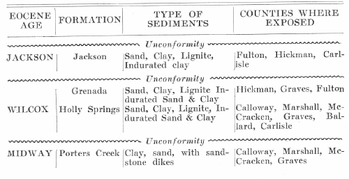
As to age the sediments range from the Midway through the Wilcox to the Jackson, and most likely represented in the basal portions of the so-called "Lafayette" sand and gravel. The middle Eocene or Claiborne deposits are not represented in Kentucky nor in the surface exposures in Tennessee, so far observed. The deposits of Wilcox (Holly Springs and Grenada) comprise the major portion of the Jackson Purchase region. The areal extent of the deposits of Jackson age is very small, as they outcrop only along the bluff of the Mississippi River in the vicinity of Hickman and Columbus.
|
Table of Tertiary Formations in Kentucky |
 |
The earliest reconnaissance report on the Tertiary of western Kentucky was that
of Loughridge.1 Loughridge recognized in the region the following
formations or units:
Lagrange group (of Safford's Tennessee)
Lignitic (Safford's Porters Creek and Bluff Lignite)
Hickman (provisional)
He evidently confused what he termed the Hickman with the clay and sand of
Jackson age, and such a confusion probably arose over the consolidated beds of
clay which occur in the bluffs at Hickman and to the south of this town. He was
also confused over the age of the Porters Creek and the so-called "Bluff
Lignite" and placed them as of the same age. At present the Porters Creek is
known to be lower Eocene, and the Bluff Lignite upper Eocene.
The Lagrange was used by the earlier geologists to embrace a vast thickness of sand, clay, and consolidated material, which at the present time is divided into the Grenada and Holly Springs. Safford's work in western Tennessee was used by Loughridge as a basis for his units in western Kentucky. The Lagrange as a term has been shown to cover too large a thickness in Tennessee and Mississippi. The use of this term in the early days of embayment studies was due to there being no fossil faunas in the Lagrange; though there were many fossil floras, and some were known to Safford, Owen, Loughridge, and others, yet such fossils were not studied and made use of as at present.
MIDWAY SERIES
The term, Midway, was proposed in 1896 by Harris2 for the lower Eocene deposits farther south in the embayment region. In Kentucky the Midway is represented only by the Porters Creek clay with a small thickness of grayish sand at or near its top and numerous sandstone dikes, whereas in the southern portion of western Tennessee and Mississippi the Clayton (impure) limestone is present as its basal member.
The Porters Creek clay extends from the Tennessee line in a very broken manner through Calloway, Marshall, and McCracken counties. Alluvium and the Plio-Pleistocene deposits conceal it in many places, and while it is quite certain from well records that it occurs as a belt through Calloway, Marshall, McCracken, and Ballard counties, yet it has been mapped only where it is exposed on the surface. The Porters Creek belt is nowhere more than two and one-half to three miles wide, and only a small area of it occurs in Graves County in the extreme northeastern part.
The name, Porters Creek, was introduced by Safford during the sixties of last century from the occurrence of the clay along Porters Creek, west of Middleton, Hardeman County, Tennessee. This clay is very persistent in its lithologic character throughout Kentucky and Tennessee. It is known locally as "soapstone" from its greasy feel when dry. At the top of the Porters Creek clay in McCracken County there is a two-foot bed of sand, which carries marine pelecypoda and gastropoda.
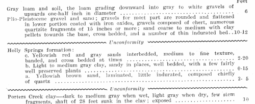
The Porters Creek clay is a light gray to a dove color, the lighter color prevailing when it is dry. It is not indurated to any extent though it is very hard when dry and surprisingly light in weight. It is the easiest Tertiary unit to recognize in western Kentucky, from it conchoidal fracture, its hackly nature of weathering, color, and its field relations. It contains small muscovite flakes at times, but it is usually very fine grained and no particles except mica showing. It is of marine origin as shown by a few molluscs, foraminifera, and fish scales. Three miles south of Paducah, McCracken County near the old Paducah-Mayfield road the clay contains beautifully preserved fish scales, and casts of marine mollusca. A few plant remains have been found by L. C. Glenn near Middleton, Tennessee. The Porters Creek where the thickest exposure is known to occur, 2½ miles southeast of Elva, Marshall County, measures 35 feet. According to L. C. Glenn, the Porters Creek is as much as 150 feet thick3 at Wickliffe, Ballard County. The only contact of the Porters Creek clay and the overlying Holly Springs formation found in Kentucky is in the railroad cut of the Illinois Central new freight line between Fulton and Metropolis, in what is known as the Coleman Cut, southwestern part of McCracken County. Here the clay beds dip almost south and strike about east and west.
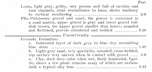
|
Section in Illinois Railway Cut, 2½ miles north of Graves
County line, |
 |
WILCOX GROUP
The Wilcox in the embayment region farther south is composed of the Akerman, Holly Springs, and Grenada. The Akerman wedges out south of the Tennessee-Mississippi line, certainly it is not exposed in western Tennessee. The Grenada and Holly Springs extend from Tennessee into Kentucky. Among the earlier geologists this group was known as the Lagrange. The separation into the above units has been brought about within the last quarter of a century, chiefly through the paleobotanic studies of Berry, which will be referred to later. The name, Wilcox, takes its source from Wilcox County, Alabama, and was first used as a lithologic term for the Nanafolia, Tuscahoma, Bashi, and Hatchetigbee of Alabama by Crider4. The Holly Springs and Grenada were named after towns in Mississippi and were proposed in 1913 by Lowe5. The Holly Springs and Grenada have been mapped, and studied in western Tennessee by the writer and R. L. Collins6.
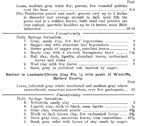
The Holly Springs sediments consist of coarse to fine sand and lenses of light and lignitic clay with all gradation of colors and several varieties of commercial clays, such as wad, sagger, and ball, which can be blended, and both the sand and clay may be consolidated by iron oxides. The sand is well rounded down to certain sizes and consists largely of quartz. Nowhere have any fossils been observed in the sand except a few fragments of silicified wood. The clay when free from sand is mined and shipped from six pits at present, five of which are located in Graves County and the sixth near Wickliffe, Ballard County.
The Holly Springs clay in certain beds abounds in leaf impressions a few fruits,
cones, flower petals, and stem fragments. The massive ball clay does not show
any leaf impressions to any extent. They are the most abundant in the yellowish
gray clay and in the lighter varieties of the lignitic clay. A number of
localities have been collected from as is shown in subsequent pages. The
following localities have been examined and a great number of specimens
collected during the summer of 1929, but as yet all these have not been
determined and described by E. W. Berry:
LeCleade Christy clay pit, Wickliffe, Ballard County.
Abandoned clay pit south
of Boaz, Graves County.
Pit of the Kentucky Clay Company, Viola, Graves County.
Pit No.4, Ky.-Tenn. Clay Mining Co., Pryor, Graves County.
The Grenada consists of sand and clay and thin layers of indurated sand and clay. On the average, the sand of the Grenada is distinctly finer than that of the Holly Springs, and yields no fossils. The clay varies in color from a light gray and almost white to lignitic. In Kentucky the Grenada furnishes very few fossil floras. The clay is more of a hackly nature on weathering, and is difficult to differentiate from the Holly Springs clay.
The Wilcox beds are fairly thick, but no one section of either exposes the entire individual series. Sections have been recorded by Loughridge, Glenn, and Berry, and a number of well records are available. The total thickness of the Wilcox in western Tennessee is probably less than 2,000 feet, and the thickness in Kentucky is less than this.
|
Section in LeCleade-Christy
Clay Pit, ¼ mile south of |
 |
|
Section in Illinois Central Railway Cut, at Baltimore. Hickman County. |
 |
List of fossil floras described by E. W. Berry7 collected at Wickliffe, Ballard County.
Anacardites metopifolia Berry
Banisteria pseudolaurifolia Berry
Banisteria
wilcoxiana Berry
Banksia saffordi Berry
Banksia tenuifolia Berry
Carapa eolignitica Berry
Cassia fayettensis Berry
Cassia glenni Berry
Cassia marshallensis Berry
Cupanites eoligniticus Berry
Cupanites loughridgii Berry
Dryophyllum moorii Berry
Dryophyllum puryearensis
Berry
Dryophyllum tennesseensis Berry
Engelhardtia ettingshauseni Berry
Exostema
pseudocaribaeum Berry
Ficus denveriana Berry
Ficus wilcoxensis Berry
Inga wickliffensis Berry
Juglans berryi Berry
Juglans schimperi Berry
Mespilodaphne pseudoglauca Berry
Mimosites variabilis Berry
Sapindus eoligniticus Berry
Sapindus formosus Berry
Sapindus linearifolius Berry
Sapindus mississippiensis Berry
As regards the age of the beds near Wickliffe from which these plants listed above were collected, Berry remarks as follows: "These species indicate a stratigraphic position at about the boundary between the Holly Springs sand or middle Wilcox and the Grenada formation or upper Wilcox of the northern Mississippi section or slightly higher (younger).”
Somewhat prior to 1888, the date of the publication of the report by Loughridge, a collection was made at Wickliffe, Ballard County and another from Boaz Station, Graves County by Loughridge, and submitted to Lesquereux for determination. These forms are listed by Loughridge.8 Lesquereux determined these forms and later they were arranged by Knowlton and published in Volume 11 of the Proceedings of the U. S. National Museum, only two forms being figured. These forms are as follows given according to Lesquereux and according to Berry: (See Prof. Paper, op cit., pp. 23-24).
Flora from Wickliffe, Ballard County
LESQUEREUX'S BERRY'S DETERMINATIONS
|
LESQUEREUX'S |
BERRY'S |
| Myrica elaenoides Lesq. Myrica copeana Lesq. Ficus multinervis Herr Sapindus falcifolius Herr |
Myrica elaenoides Lesq. Cupanites loughridgii Berry Ficus myrtifolius Berry Ficus wilcoxensis Berry |
Sapindus dubius Herr |
Mixed forms: Engelhardtia ettingshauseni Exostema pseudocaribaeum Banisteria wilcoxiana Ficus wilcoxiana, and Carapa eolignitica |
| Sapindus angustifolius Lesq. Laurus californica? Lesq. Quercus saffordi Lesq. Juglans rugosa Lesq. Salix angusta Herr Salix media Al Braun Ailanthus leaf fragment |
Sapindus mississippiensis Berry Mespilodaphne pseudoglauca Berry Banksia saffordi Berry Juglands schimperi Lesq. Sapindus linearifolius Berry Not recognized Not afterward referred to and lost |
FROM BOAZ, GRAVES COUNTY
|
LESQUEREUX'S |
BERRY'S |
| Sapindus falcifolius Herr Quercus nervifolia Al Braun Quercus cuspidata Ung. Laurus californica Lesq. Ficus multinervis Herr |
Ficus wilcoxensis Berry Banksia saffordi Berry Dryophyllum tennesseensis Berry Mespilodaphne pseudoglauca Berry Ficus myrtifolius Berry |
During July 1925, the writer and R. L. Collins made a collection of Holly Springs plants from the clay pit of the Bell City Pottery Company, at Bell City, southeastern Graves County; these plants have been determined by Professor E. W. Berry of the Johns Hopkins University, and very kindly furnished by him for this report.
List of Holly Springs plants from the pit of the Bell City Pottery, Graves County
Anacardites metopifolia Berry
Anacardites puryearensis Berry
Anoma robertsi Berry
Apocynophyllum sapinifolium Hollick
Aralia (?) semina Berry
Banksia tenuifolia Berry
Bombacites eocenicus Berry
Carpolithus kentuckyensis Berry
Cassia puryearensis Berry
Dryophyllum tenneseensis Berry
Glyptostrobus europaeus (Brongn.) Herr
Juglans schimperi Lesq.
Nyssa wilcoxiana Berry
Oreodaphne obtusifolia Berry
Oreodaphne pseudoguianensis Berry
Parrotia cuneata (Newb.) Berry
Rubiacites sphericus Berry
Sabalites grayanus Lesq.
Sterculia knowltoni Berry
Taxites sp.
Terminalia vera Berry
Ternstroemites ovatus Berry
JACKSON DEPOSITS
The name, Jackson, was proposed for beds of upper Eocene age occurring near Jackson, Mississippi, and was first used by Hilgard in 1860.9 The Jackson deposits or uppermost Eocene occur along the bluffs of the Mississippi River. These beds are of lower Jackson age as indicated by their floral content. In Mississippi the Jackson consists of two members namely, the Moody marl or basal member, and the Yazoo clay, and here the Jackson beds are conformable on the Claiborne and at their top with beds of Oligocene age. In Tennessee the Jackson deposits lie unconformably upon the Grenada, and presumably this holds true for Kentucky, though no actual contact was seen.
The age of the Jackson deposits was not recognized by the earlier geologists as has been pointed out. The first work of any note to be done was a result of the visit to the Columbus locality, Hickman County by Lesquereux in company with Sir Charles Lyell and D. D. Owen. After making a study of the collection of fossil floras found near Columbus, Lesquereux assigned them to the Pleistocene.10 Later the deposits from which these plants were collected were given the name, Hickman group by Loughridge11 and were regarded by him as the oldest of the Eocene sub-divisions.
In 1903 L. C. Glenn collected plants near Columbus, Hickman, and Wickliffe, and sent them to Knowlton for determination, and the latter assigned them to the Pliocene.12 It remained for E. W. Berry to describe the plants from these beds in 1924 from collections made from a number of localities. These plants are described and figured in a recent publication.13
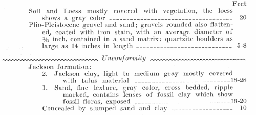
The beds of Jackson age have not been found to outcrop anywhere in Kentucky except in a broken manner along the Chickasaw Bluffs. The southernmost exposure begins about one mile south of the town of Hickman, Fulton County, extends through the town and about one-half mile north; the other exposure extends along the bluffs in Hickman County. To the east of the bluffs the Jackson does not appear exposed and it is covered by the Plio-Pleistocene deposits.
The sediments consist of sand, clays, and beds of considerable thickness of indurated clay; some lignite occurs in places, more so in Tennessee than in Kentucky. The sand is distinctly finer in texture than the sands of the Holly Springs and Grenada, and has a greenish color. It contains a great deal of clay and angular fragments of lignite. Lamination and cross bedding are very common. The clay is usually light gray, light brown to black, grading into lignite. The lignite is thin and quite impure. In Tennessee thick exposures of Jackson are found at Mayberry Leap, Richardson's Landing, Randolph, and Fulton, also north of Reelfoot Lake and at Lenox, and sections have been measured which attain as much as 120 feet. South of Hickman, Fulton County, the Jackson beds are between fifty and sixty feet in thickness and have about the same general sequence as in northwestern Tennessee.
|
Section on the Chickasaw
Bluff, 1 mile south of |
 |
|
Section on the
Mississippi river, 2½ miles south of |
 |
List of fossil plants collected from near Columbus, Hickman County
by Owen and Lesquereux, and determined by Lesquereux.14
Quercus vireus Michx.
Castanea nana, Muhl.
Ulmus alata Michx.
Ulmus minuta? Gopp.
Planera gmelini, Michx. (P. Hickmanensis, Berry)
Prinos integrifolia Ell.
Caenothus americanus Lesq.
Carya olivaeformis Mitt. (Hicoria jacksoniana, Berry)
Gleditschia trecanthos Lesq.
Acorus calamus Lesq.
Alnus or Betula catkins
List of Jackson floras from near Columbus.
(E. W. Berry, U. S. Geol. Survey Prof. Paper 92, pp. 107-110, 1924.)
Hicoria jacksonia Berry
Menispermites carolinaformis Berry
Tecoma preradicans Berry
List of Jackson plants from Hickman.
(E. W. Berry, U. S. Geol. Survey Prof. Paper 92, pp. 107-110, 1924.)
Palmocarpon sp.
Palm rays
Hicoria jacksonia Berry
Hicoria rostrataformis Berry
Planera hickmanensis Berry
Menispermites carolinaformis Berry
Capparidocarpus sphericus Berry
Bauhania wadii Berry
Papilionites erythrinaformis Berry
Lonchocarpus anceps Berry
Liquidamber sp.
Fagara catahoulensis coriacea Berry
Fagara catahoulensis major Berry
Rhamnites krugiodendroides Berry
Grewiopsis wadii Berry
Tecoma preradicans Berry
Carpolithus bumeliaformis Berry
List of Jackson plants ½ mile north of Hickman.
(E. W. Berry, U. S. Geol. Survey Prof. Paper 92, pp. 107-110, 1924.)
Taxodium dubium (Sternb.) Herr?
Hicoria rostrataformis Berry
Planeria hickmanensis Berry
Banksia jacksonensis Berry
Liquidamber sp.
Fagara catahoulensis coriacea Berry
Fagara catahoulensis elongata Berry
Burserites fayettensis Berry
Grewiopsis wadi Berry
List of Jackson plants from 5 miles south of Hickman.
(E. W. Berry, U. S. Geol. Survey Prof. Paper 92, pp. 107-110, 1924.
Fagara catahoulensis elongata Berry
Planeria hickmanensis Berry
Hicoria jacksoniana Berry
Paliurus catahoulensis Berry
The Jackson plants have been collected and described from 40 localities, from Georgia as far north as Kentucky, and west to the Rio Grande. These plants comprise 133 species of which 18 species have been found in Kentucky. These plants probably represent coastal plain forms, living around small ponds and bays of Jackson seas according to Berry.
No fossil faunas have been described from western Kentucky. The wing of a termite was found in the sandy clay, 2½ miles south of Columbus, Hickman County in July 1929. The Moody marl member of the Jackson in Mississippi contains well preserved fossils, and the Yazoo furnishes Zeuglodon remains. Something like 214 species of marine invertebrates have been found in the Jackson of Mississippi.
QUATERNARY SYSTEM
The Quaternary system is made up in part by the gravel and sand of Plio-Pleistocene age, the loess, and the alluvium. The writer regards the Columbia loam not as a separate formation but a weathered phase of the loess and more especially as an eastward extension of the loess, as it becomes coarser from the Mississippi river to the east and from the Ohio river to the south. A table of the Quaternary formations is as follows:
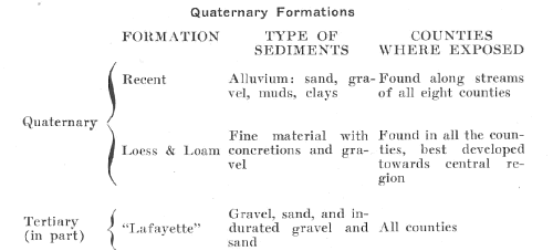 |
PLIO-PLEISTOCENE (LAFAYETTE) DEPOSITS
The so-called Lafayette, which covers most of the Jackson Purchase region, constitutes by far the greatest unit of the areal geology. The name, Lafayette, was proposed in 1891 by McGee.15 McGee in his discussion in reference cited under the footnote remarks as follows: "The Lafayette formation, as now defined, was first discriminated in northern Mississippi in 1855 and 1856 by Dr. E. W. Hilgard, and was named by him after Lafayette County, in which it is typically developed." So, it appears that McGee revived the term, and placed it before the public to the extent that it was accepted.
These deposits consist of gravel and sand, reworked from the Tertiary, Cretaceous, and Paleozoic, in other words, from whatever material available at the time of the formation of the deposits. Since these deposits are found over the youngest of the Eocene beds, the Jackson, and immediately under the loess, which is regarded as Pleistocene, the writer is inclined to interpret their age as suggested in 1925 by E. W. Berry, namely that they are of Plio-Pleistocene age.
The gravels are well rounded and many are flattened. Most of them are coated with reddish brown iron oxides, but in western Graves County and the eastern portions of Hickman, and Carlisle Counties the gravels are a light gray to almost white. Their general average size is approximately one-half an inch, thus differing in size with the Tuscaloosa gravel as well as in the degree of rounding. The gravel is composed chiefly of chert with a few of quartzite. They are contained in a matrix of sand, which varies from coarse to medium and even fine, and usually colored to about the same tone as the gravels. The gravels when broken show typical Paleozoic fossils, such as crinoid stems, brachiopods, bryozoa, pelecypods, gastropods, echinoid spines, etc. One of the interesting features is the occurrence in the gravel of large quartzite boulders, some of which measure 52 inches in their major diameter, and are about 16 inches thick. These are found in the gravels as far south as 2½ miles north of Murray, Calloway County.
The gravels are often consolidated into a conglomerate, the cementing agent being iron oxides. The sand is composed of quartz, and broken masses of chert, and a few black, heavy minerals. Often the sand does not occur mixed with the gravel, but may overlie or underlie it. Cross bedding is quite common, and bedding and orientation are frequent.
These deposits can be found resting on every older member in the Jackson Purchase region, including the St. Louis chert and limestone. In fact, these deposits have been found by the writer far to the east in Crittenden County, and south of Owensboro. There are no means or correlation except by lithology and stratigraphic position. Gravel and sand on the Atlantic Coastal Plain have been termed Lafayette by McGee, Fontaine, Ward, and others, but correlation with these deposits in the embayment area in the absence of fossils is impossible. It is not necessary to tabulate any sections of these gravels and sands, for their characters are much the same over the entire area, and any of the sections given above except the one in the clay pit at Wickliffe, Ballard County, will show gravels.
LOESS AND LOAM
The loess occurs over most of western Kentucky when the loam is considered to be a weathered and an eastern extension of the loess. Whenever the so-called loam is found on the Mississippi River bluffs it shows as nothing more than an upward gradation of the loess, being slightly more porous, full of cavities of fairly large size, root channels, and having more yellow tones. The loam thins to the east, and often is not more than one to two feet thick. The loess along the bluffs reaches as much as 40 feet in thickness, and is well exposed along the river edge wherever the river is undercutting the bluffs, otherwise on the abandoned bluffs.
The loess is usually a grayish color to a brown, but upon weathering it assumes a yellowish brown. Along the bluffs it shows the vertical jointing feature very well. It is thickest south of Hickman and in the vicinity of Columbus. Much of the soil of the four counties bordering on the Mississippi river and McCracken County on the Ohio River is of loess origin, and it forms a very fine soil. It is very easy to know when one is on loess roads either in dry weather or in rain on account of the immense amounts of dust or mud respectively.
The loam is found far to the east in the three counties of Graves, Calloway, and
Marshall, and it is found lying upon the chert and limestone of Mississippian
age. It may be Recent in part, but everywhere it is found lying upon the
P1io-Pleistocene gravel and sand. It never contains any fossils so far observed,
and its only resemblance to the loess is its lithology and stratigraphic
position.
The loess contains great numbers of gastropods in some localities, but the
variety is small. The writer has collected loess fossils from western Tennessee,
and from the deposits along Crowley's Ridge near Madison and Forrest City,
Arkansas, and the Kentucky forms show a less variety than any of the others. The
Arkansas localities show two pelecypods, but the Kentucky forms are all
gastropods. The forms reach as much as one inch in diameter, some with a deep,
others with a shallow umbilicus. The fossils are limited to the deposits near
the river, and do not occur more than three miles east of the river.
RECENT ALLUVIUM
The alluvium occurs along all the permanent and many of the intermittent streams, and is very extensive along the Tennessee, Ohio, and Mississippi Rivers. It consists of clays, muds, silts, sands, and gravels. A considerable amount of the area of the Jackson Purchase region is covered with alluvium due to the fact that the region is so flat, and has such a net work of streams, the majority of which are active much of the year.
BIBLIOGRAPHY
Loughridge, R. H., Report on the geological and economic features of the Jackson
Purchase Region.
Ky. Geol. Survey, Report F, 1888, 357 pp. 21 Illus. 3 maps.
Glenn, L. C., Underground waters of Tennessee and Kentucky west of the Tennessee
River.
U. S. Geol. Survey, Water Supply Paper 1640, 1906, 173 pp. 7 pls. 13 figs. 1
map.
Roberts, Joseph K, and Collins R. L., The Tertiary of West Tennessee.
Am. Jour. Sci., Vol. 12, 1926, pp. 235-243.
Roberts, Joseph K., Tertiary Stratigraphy of West Tennessee.
Geol. Soc. Am. Bull., Vol. 39, 1928, pp. 435-446. 2 tables.
Roberts, Joseph K., Clays of the Jackson Purchase Region, Ky.
Econ. Geol., Vol. 25, 1930, pp. 832-836.
Roberts, Joseph K., Tertiary Deposits of Western Kentucky.
Geol. Soc. Am., Bull., Vol. 402, 1931, pp. 523-526, 1 fig.
Footnotes
1Loughridge, R. H., Report on the geological and
economic features of the Jackson Purchase region: Kentucky Geol. Survey,
Frankfort, 357 Pp. 21 figs, 3 maps, 1888.
2Harris, G. D., The Midway Stage: Am. Pal., Bull., Vol. I, pp. 18-22, 1896.
3Glenn. L. C., Underground Waters of Tennessee and Kentucky west of Tennessee
river and of an adjacent area in Illinois: Water Supply & Irrigation Paper 164,
p. 31. 1906.
4Crider. A. F., Geology and Mineral Resources of Mississippi: U. S. Geol.
Survey, Bull. 283, p. 25, 1906.
5Lowe, E, N., Preliminary Report on the Iron Ores of Mississippi: Mississippi
Geol.
Survey., Bull. 10, pp, 23-25, 1913.
6Roberts, Joseph K., and Collins, R. L., The Tertiary of west Tennessee: Am.
Jour.
Sci., Vol. 12, pp. 235-243, 1926.
Roberts, Joseph K., Tertiary Stratigraphy of west Tennessee: Geol. Soc. Am_
Bull., Vol. 39, pp, 435-446, 1928.
7Berry, E. W., The Lower Eocene Floras of Southeastern North America: U. S.
Geol. Survey, Prof. Paper 91, pp. 51-52, 1916.
8Loughridge, R. H., op. cit., App. II, p. 198.
9HiIgard, E. W., Report on the Geology and Agriculture of Mississippi:
Mississippi State Geol. Survey, Report, pp. 107, 128-138, 1860.
10Lesquereux, L., On some fossil plants of Recent formations: Am. Jour. Sci.,
Ser. 2,
Vol. 27, pp. 364-365, 1859.
11Loughridge, R. H., op. cit., pp. 37-41.
12Glenn. L. C., op. cit., pp. 38-39, 1906.
13Berry, E. W., The Middle and Upper Eocene Floras of southeastern North
America:
U. S. Geol. Survey Prof. Paper, 92, 1924.
14Lesquereux, L., On some fossil plants from the Recent formation: Am. Jour. Sci.,
Ser. 2, vol. 27, pp. 359-366, 1859.
15McGee, W. J., The Lafayette formation: U. S. Geol. Survey, 12th Ann. Rept.,
Part I,
p. 497, 1891.
|
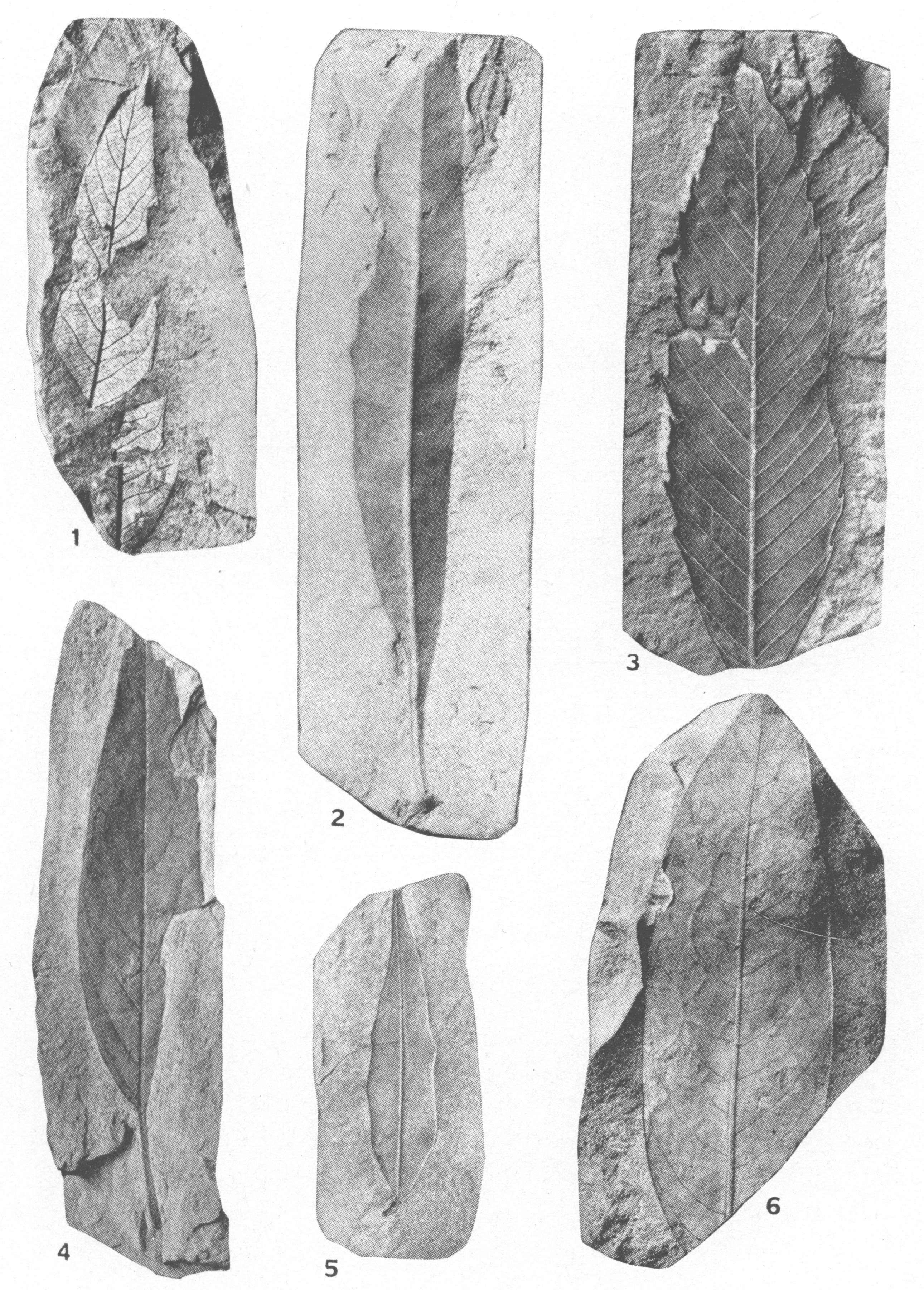
Explanation of Plate LXIX Wilcox Floras |
 |
|
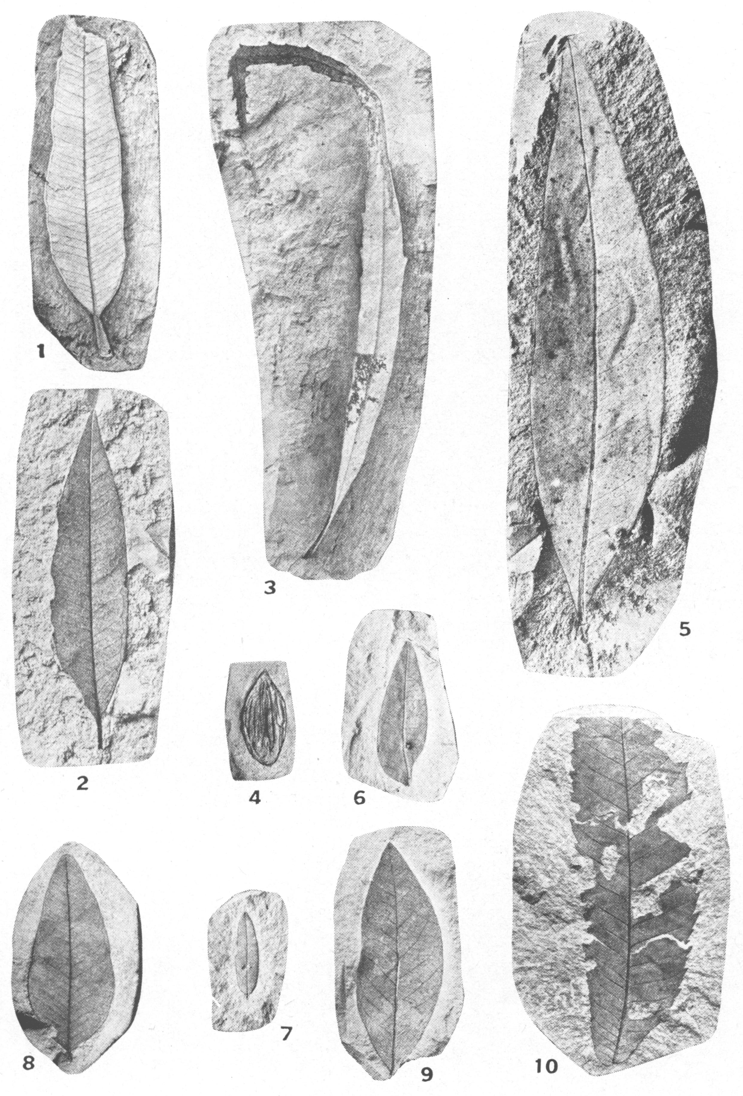
Explanation of Plate LXX Wilcox Floras |
 |
|
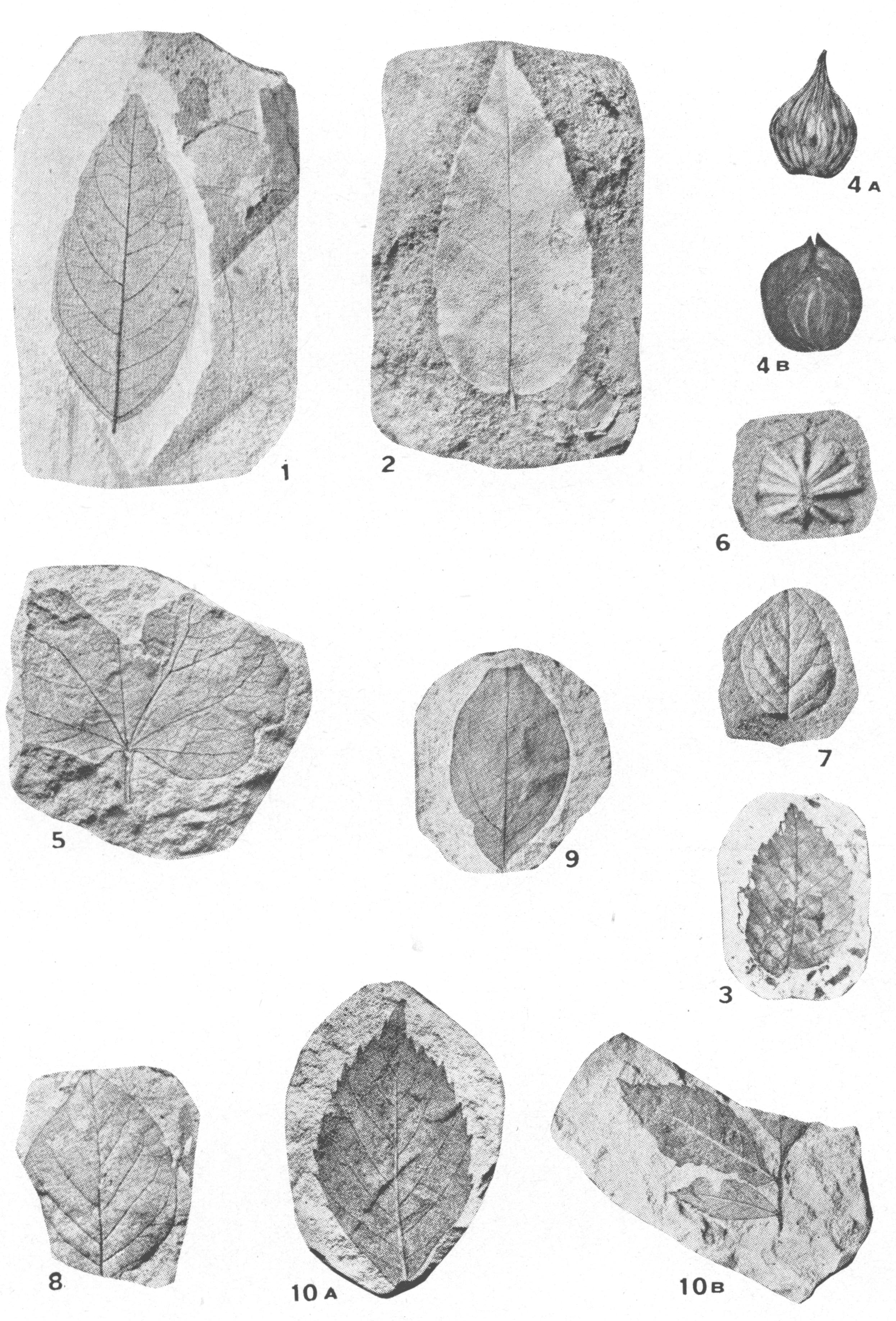
Explanation of Plate LXXI Floras of Jackson Age |
 |