The Kentucky Geological Survey has archived this material, meaning (1) it is for reference, research, or recordkeeping; (2) it was created before April 24, 2026;
(3) and the material has not been changed or altered since being archived. Please refer to our KGS Accessibility page for more information.
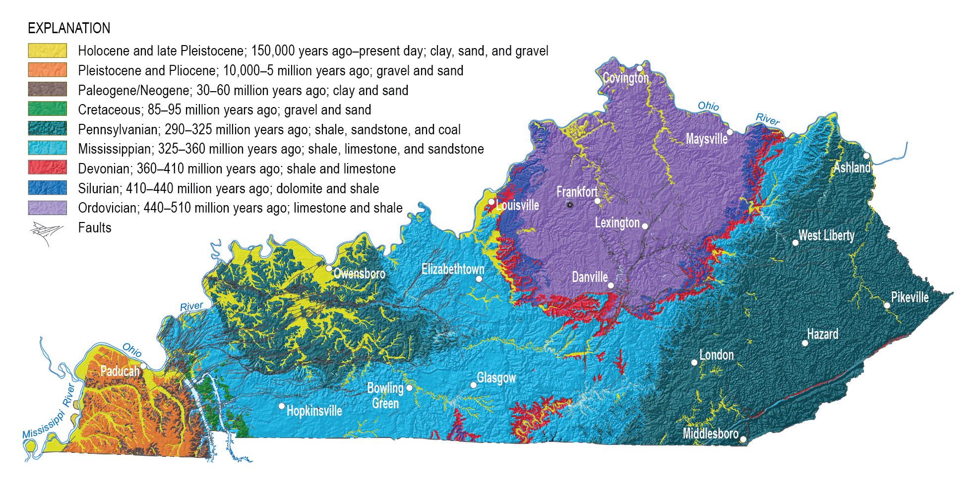
County Geology: See simplified geologic maps of Kentucky counties with explanations of how the geology influences land-use planning
Geologic Time: Geologic time on Earth has been divided into intervals called eons, eras, and periods.
Topographic and Geologic Quadrangle Maps: A description of maps in Kentucky and map indexes. Kentucky was the first state in the Nation to be topographically mapped at a detailed scale (1:24,000) and the first (and only) state to be completely geologically mapped at a detailed scale (1:24,000).
Earth History Key Links: Annotated links to selected Web sites for important times in earth history.
Links
The Geology of Kentucky--A text to accompany the Geologic Map of Kentucky, by Robert C. McDowell: at the U.S. Geological Survey web site. This is the full-text version of the original out-of-print publication that summarized the geologic quadrangle mapping program. This program was a joint U.S. Geological Survey-Kentucky Geological Survey project that took approximately 20 years and hundreds of geologists to complete. As a result, Kentucky was the first state to be completely geological mapped at a detailed scale.
The U.S. Geological Survey also has information about the nation's geology. Tapestry of Time and Terrain, U.S. Geological Survey. 2000. A great site for visualizing the connection between bedrock geology and physiography (landscapes) and also for illustrating the distribution of rocks of different ages around the United States. The map on the front page is a combination of a 3-D shaded relief map and a geologic map. The Two Maps option shows each map separately and then merges them together using a Quicktime® plug-in. The Description of Features Option lets you zoom in on selected physiographic regions shown on the map and provides specific information about those regions. The Rock of Ages option shows the legend (explanation) for the geologic map (classified by intervals of geologic time). You can choose a time period to see where rocks of that age are exposed at the surface in the United States. There is a short description of the rocks and fossils from that time period, and a series of options for zooming in on specific regions. The web preview is also available on CD from the USGS for a low cost.
Geolex. U.S. Geological Survey. Want to find information about a specific rock unit name? This site is an online version of the lexicon of stratigraphy, which is a compilation of rock unit names used in the United States. The Website allows searches by rock unit names, ages, or region. Provides information on the usage, age, type locality, subunits and history of the rock unit name. Also, provides an online version of the North American Stratigraphic code if you are interested in understanding how rock units are defined and named.