
The Kentucky Geological Survey has archived this material, meaning (1) it is for reference, research, or recordkeeping; (2) it was created before April 24, 2026; (3) and the material has not been changed or altered since being archived. Please refer to our KGS Accessibility page for more information.
KGS Home > Geology of Kentucky
Jabez Sandstone Member, Harmon Creek
Location: On the southern shore of Lake Cumberland, on the west side of the mouth of Harmon Creek.
Nad-83 Decimal Degree (lat, long): 36.914179, -84.961225
7.5-minute Quadrangle: Jabez (Thaden and Lewis, 1966)
County, State: Wayne, Kentucky
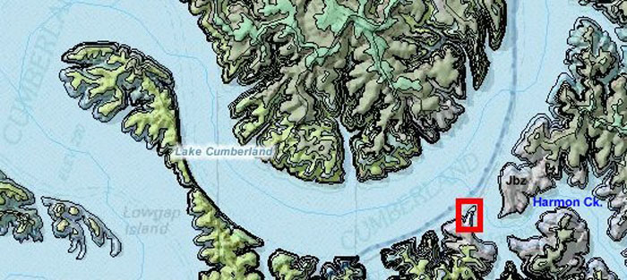
Figure 1. Location of the type section of the Jabez Sandstone Member, Fort Payne Formation.
The Jabez Sandstone is colored light purple (lilac) on the map.
Overview: The type section of the Jabez Sandstone Member crops out along Lake Cumberland at the mouth of Harmon Creek beneath Rogers Cemetery. The section is only accessible by boat. The sandstone was mapped east, west, and north of the type section in the Jabez 7.5-minute quadrangle (Thaden and Lewis, 1966). Later, Kepferle and others (1980) formally defined the sandstone as a member of the Fort Payne Formation. An outcrop of the sandstone is accessible by road at the Cave Springs Road boat launch, via Ky. 3277 and Ky. 196.
Photographs were taken on August 21, 2008, when lake levels were low, at 680 ft. The base of the sandstone is approximately 745 ft, the top is approximately 770 ft, so the upper part of the sandstone is exposed even at high water levels.
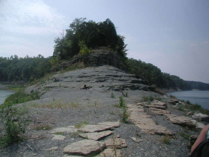
Figure 2. Type section of the Jabez Sandstone Member, Fort Payne Formation, Lake Cumberland.
Description: At the type section, the Jabez Sandstone Member is very fine to coarse grained, quartzose, with massive to poorly defined horizontal lamination and bedding, less commonly crossbedded (Figs. 3-4), with abundant pelmatozoan (mostly crinoidal) debris. It is cemented with chalcedony, calcite, or dolomite (Kepferle and others, 1980).

Figure 3. Jabez Sandstone Member, Fort Payne Formation.
(A) View of the sandstone from shoreline at low water level.
Weathering expands joints in thin-bedded sandstone.
(B) Bedding within the cliff face.
(C) Measured section at the type section.
From Lewis and Potter (1978, Fig. 24, p. 32).
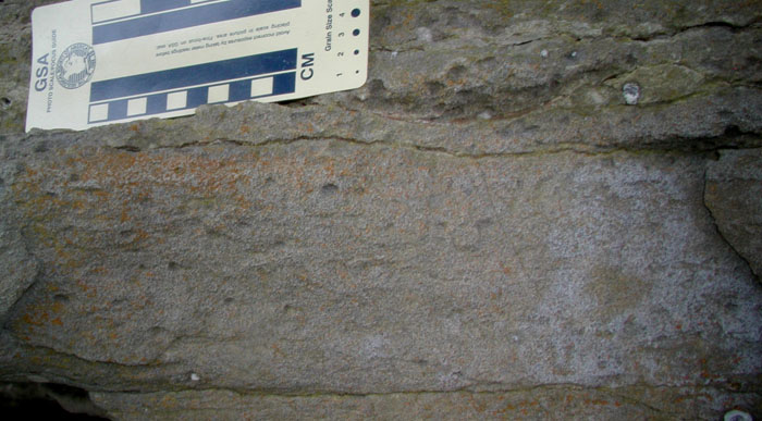
Figure 4. Detail of low-angle crossbedding showing mottled texture from bioturbation,
and distinct horizontal burrows in upper part of the bed, at the type section of the Jabez Sandstone Member, Fort Payne Formation.
Thaden and Lewis (1966) mapped the sandstone as a flat-bottomed to slightly westward-downdipping unit, which interfingered with lateral reef limestones. The so-called reef limestones represented the mud mounds and sometimes other carbonates. Kepferle and others (1980) later determined that the Jabez Sandstone Member forms a northwest-trending prism as a clinoform (or coalesced series of clinoforms) along the crest of the Borden delta front. The sandstone is interpreted to dip downward and grade into Fort Payne siltstones or the Cane Valley Limestone Member (originally mapped by Thaden and Lewis (1966) as reefal limestone on the Jabez geologic quadrangle map) to the southwest. The Cane Valley Limestone is not reefal, nor is it a carbonate buildup like the mud mounds.
The Jabez Sandstone Member is capped updip by the Cane Valley Limestone Member or the Salem-Warsaw Formations, including the Harrodsburg Limestone (see stratigraphic section), although the upper contact is not well exposed along the shores of Lake Cumberland. Both the lower and upper parts of the sandstone interfinger with thin limestones of the Fort Payne Formation (Kepferle and others, 1980), although the basal contact is locally sharp.
At low water, typical siltstones and thin carbonates of the Fort Payne Formation are well exposed below the Jabez Sandstone. A thin dolomitic limestone exhibits rectangular weathering and erosion along well-defined joint planes (Figs. 5-6).
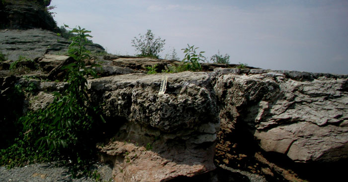
Figure 5. Dolosiltstone and overlying shale below the Jabez Sandstone at low water level (680 ft),
at the type section of the Jabez Sandstone Member, Fort Payne Formation.
.
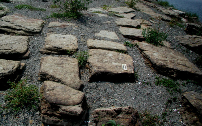
Figure 6. Rectangular fractures in the Fort Payne Formation are
expanded by weathering at the type section of the Jabez Sandstone.
.
Similarity to Knifley Sandstone Member
The Jabez Sandstone Member is separated from, but southeast and along strike of, the much more broadly distributed Knifley Sandstone Member (Sedimentation Seminar, 1972; Kepferle and Lewis, 1975). The Jabez is coarser grained, but otherwise similar to the Knifley Sandstone Member (Sedimentation Seminar, 1972; Kepferle and others, 1980). Both are clinoform features developed along the crest of the Borden delta and have similar upper and lower contacts. Like the Jabez Sandstone, the Knifley is typically mottled, with crinoidal debris, brachiopods, and gastropods locally common. Trace fossils in the Knifley Sandstone Member include Scalarituba and Zoophycos (Kepferle and Lewis, 1975), similar to traces in exposures of the Jabez Sandstone Member along the north shore of Lake Cumberland (Figs. 7-10).
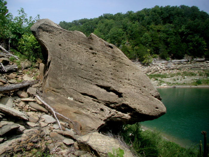
Figure 7. Fall blocks of Jabez Sandstone Member, Fort Payne Formation,
on the northern shore of Lake Cumberland north of the type section.
Location N36 55.270, W84 58.140.
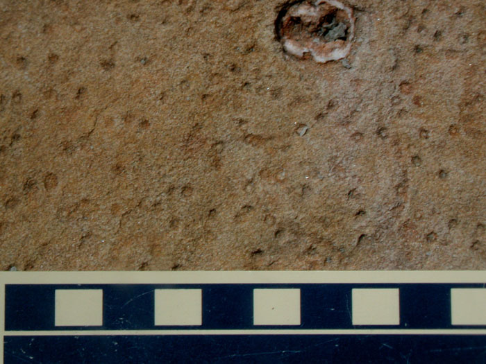
Figure 8. Paired Arenicolites burrows on float blocks of the Jabez Sandstone Member,
north shore of Lake Cumberland. Scale in centimeters.
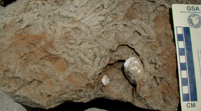
Figure 9. Scalarituba burrows on float blocks of the Jabez Sandstone Member,
north shore of Lake Cumberland. Scale in centimeters.
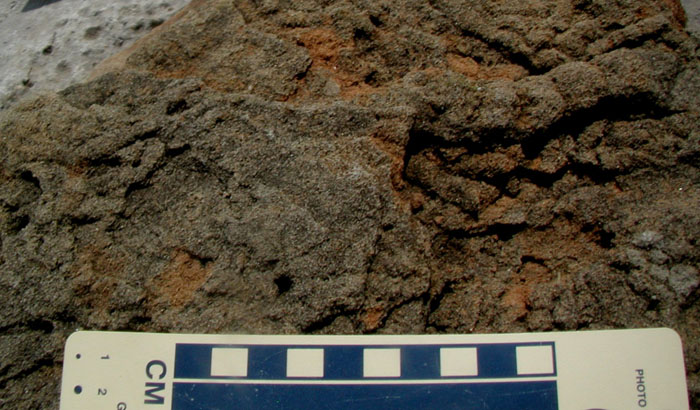
Figure 10. Large Scalarituba burrow on float block of the Jabez Sandstone Member,
north shore of Lake Cumberland. Scale in centimeters.
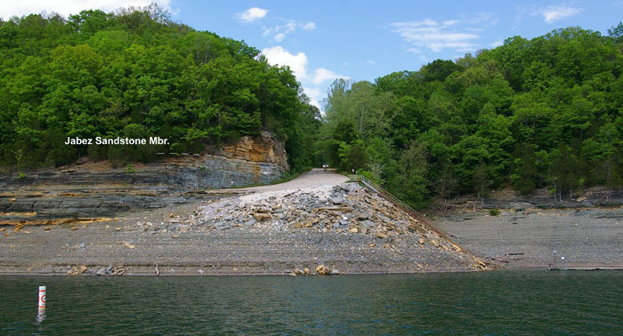
Figure 11. Jabez Sandstone Member, at Cave Springs Road boat launch (N36°55'10.8", W84°59'33.7").
The top of the sandstone is at approximately 720 ft.
Environment of Deposition
Both the Jabez and Knifley Sandstone Members have been interpreted as subaqueous barrier sand shoals developed landward of Cane Valley carbonate shoaling banks (Sedimentation Seminar, 1972). Intercalated limestones, fauna, and trace fossils confirm a subaqueous, open-marine environment of deposition for the Jabez Sandstone Member.
References
Continue to Lake Cumberland debrite
Back to Fort Payne Formation Field Trip in the Lake Cumberland Region
Back to top of Geology of the Fort Payne Formation