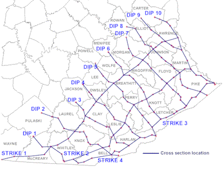
A series of 14 regional geologic cross sections has been made that illustrates the structure and stratigraphy of subsurface rock units in eastern Kentucky. Subsurface geologic data collected by oil and gas companies were used to construct the cross sections. These cross sections illustrate Mississippian rocks, which range from 325 to 360 million years old. Several of the geologic formations contain oil and natural gas, which are produced from wells drilled as deep as 4,000 feet. The cross sections document the geologic structure, thickness, lithology, and porosity of the rock units. These are important parameters used by geologists and engineers in their exploration for hydrocarbons, and this research will benefit the oil and natural gas industry working in eastern Kentucky.
The "Big Lime" zone, a limestone and dolostone unit shown on the cross sections, is an important hydrocarbon reservoir in eastern Kentucky. An average oil or gas field producing from the Big Lime contains 30 to 40 wells. Such a field will produce from 1 to 1.5 million barrels of oil, or 4.5 to 6 billion cubic feet of natural gas. At current natural gas prices ($5/MCF), these hydrocarbons are worth from $22.5 to $30 million. A field of this size will generate from $1.4 to $1.8 million in severance taxes to State and local governments.
These cross sections resulted from a research project funded by three energy companies: Cabot Oil and Gas, Pittsburgh, Pa.; Eastern American Energy, Charleston, W.Va.; and Penn Virginia Oil and Gas, Duffield, Va. The work was conducted from 1994 to 1996.
These cross sections are available for downloading at no charge from the KGS Web site. Files are in Adobe Acrobat format (PDF), and can be viewed and printed with the free Acrobat Reader. These sections vary in size up to 67 inches long, and are best printed on a large-format color plotter. They can be printed at a reduced scale (page-size) using the "fit to page" option in the print parameters. They could also be printed as a mosaic of multiple pages if the printer supports that option.
Map and Chart Series 14 is also available for purchase on CD-ROM from the Kentucky Geological Survey Publication Sales office. In addition to containing the cross sections, the CD-ROM also contains the digital well log data in LAS format (ASCII). Digital log files for 163 wells used in the cross sections are included. Information on free viewing software for the LAS files is included. The cross sections are also available in hard copy format, plotted in color, either individually or as a complete set. To purchase the CD-ROM, call toll-free (877) 778-7827.
Pricing for Map and Chart Series 14:
File List: Regional Subsurface Cross Sections of the Mississippian System
Click to view cross section pdf file