
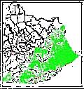
Mississippian carbonates are one of the largest classes of hydrocarbon reservoirs in the state. The Ft. Payne, Warsaw, St. Louis, Ste. Genevieve, and Newman/Slade (Big Lime of drillers) formations make up this interval in the Illinois and Appalachian Basins of Kentucky. An understanding of the depositional and diagenetic controls on hydrocarbon reservoir development and the prediction of reservoir quality in these rocks is vital to the oil and gas industry as it develops exploration concepts and enhanced-oil-recovery programs. This project was initiated in 1994 in the Appalachian Basin with the collection of stratigraphic data for the Mississippian Newman (Big Lime) Limestone and adjacent units in over 7,700 wells. Stratigraphic tops were collected from geophysical logs and driller's logs for stratigraphic units from the top of the Mississippian (Pennington Formation) to the top of the Devonian Ohio Shale. These data are now available in digital format on diskette as open-file report OF-97-03. To order this data set please call Publication Sales at (859) 257-3896 or toll-free at (877) 778-7827.
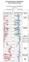
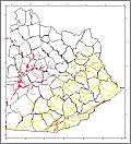
A series of regional cross sections was constructed as part of this project to illustrate the structure and stratigraphy of the rocks (their relationship in space and time to one another). The set of 14 cross sections are available as Map and Chart Series 14. The sections are available as Adobe Acrobat (PDF format) files on CD-ROM, paper plots, or online. An index map of the cross section locations is available. PDF files for all the sections are available for viewing or printing (requires Adobe Acrobat Reader).
Regional structure and isopach maps on the top of the Big Lime have been published.