Contact: Dave Harris
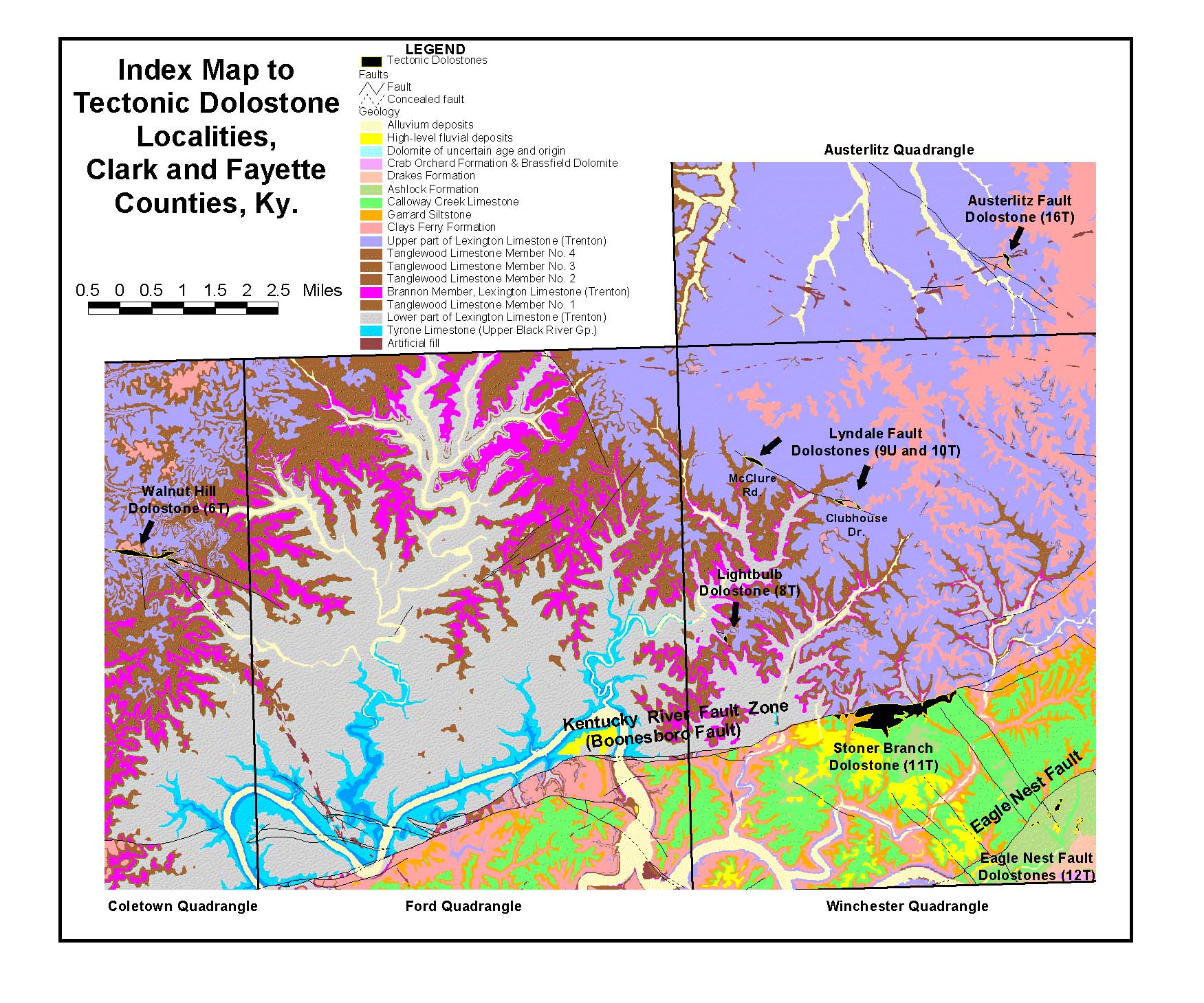
Several dolostone bodies are exposed in Clark and Fayette Counties, Ky. (geologic location map). Fault-related dolomitization has been documented in several Middle and Upper Ordovician formations, including the Lexington Limestone (Trenton equivalent) and the younger Calloway Creek Limestone. Both formations are composed of limestone throughout most of central Kentucky. In the areas of interest, the limestone has been replaced by dolomite adjacent to both major and minor faults. These dolostones have been called tectonic dolostone by Black and others (1981). Two of the larger occurrences of Ordovician tectonic dolostone are the "lightbulb" structure on Ky. 627 southwest of Winchester and the Stoner Branch dolostone, adjacent to the Kentucky River Fault. Five other dolostone bodies have been sampled. All 7 of these dolostones are shown on this geologic map. Field work and sampling are essentially complete. Petrographic and geochemical analyses of these dolostones are now in progress. More detailed information on the two most important dolostones follows.
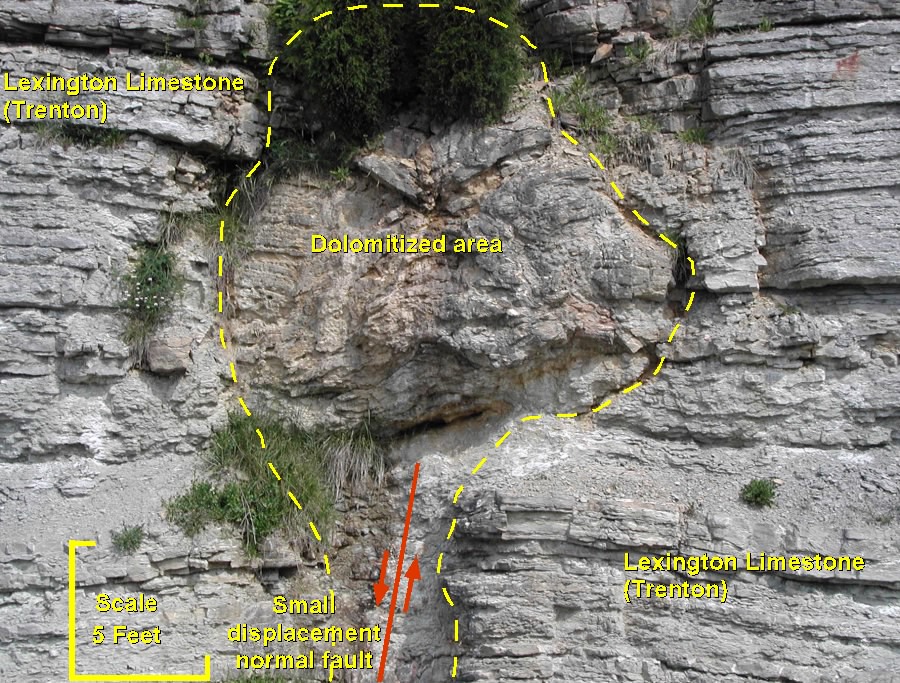
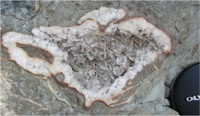
Ky. 627 LightbulbThis dolostone body occurs on the northwest side of a roadcut along Ky. 627, approximately 3.6 miles southwest of the intersection of Ky. 1958 and Ky. 627 (lightbulb dolostone on map). The irregular dolostone body, referred to as the "lightbulb" by local geologists, replaced bedded limestone of the Lexington Limestone (Trenton equivalent). The complete transition from bedded limestone to dolomite is present in the roadcut. The dolostone body is overlain by unaltered limestone at the top of the roadcut, indicating that the dolomite was emplaced by fluids moving upward along the fault. A small fault is present on both sides of the highway, but dolostone is much better developed above the fault on the northwest side of the roadcut. Only traces of saddle dolomite occur on the southeast side of the road. This dolomite body is unique in that the entire transition from limestone to dolostone is visible within a single outcrop. The lightbulb contains matrix-replacive dolomite and vugs lined with saddle dolomite (also called baroque dolomite), characterized by curved, saddle-like crystal morphology. Collapse features and contorted bedding are present within the dolostone body, indicating that significant dissolution occurred during dolomitization.
Traces of sphalerite have also been found associated with saddle dolomite at this locality. Both saddle dolomite and sphalerite occur as hydrothermal minerals.
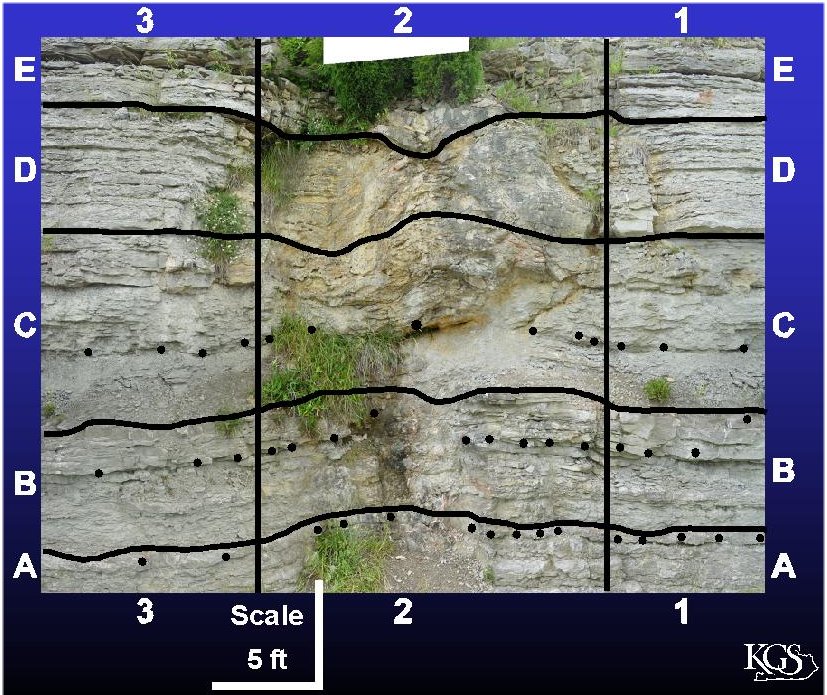
During graduate work that is still in progress, Clay Wilcox first made a photomosaic of the outcrop and defined a sampling grid to allow vertical and horizontal sample transects to be documented. Sample transects have been made horizontally across the dolostone body, extending well out into the host limestone. These samples have been thin-sectioned, and are being analyzed using transmitted light and cathodoluminescent petrography.
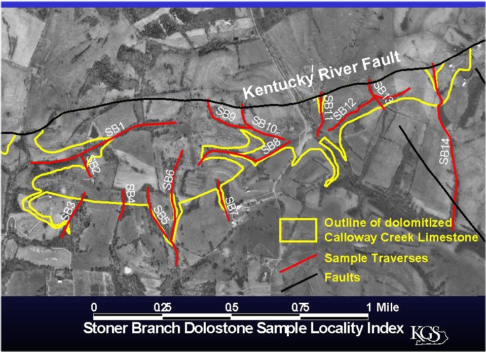
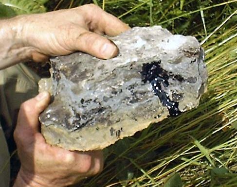
Stoner Branch DolostoneThe Stoner Branch dolostone body is immediately adjacent to and south of the Boonesboro Fault, which is part of the Kentucky River Fault System in the Winchester quadrangle. To the north, on the upthrown side of the fault, undolomitized Lexington Limestone is exposed. Downthrown, south of the fault, dolomite has replaced younger limestones of the Upper Ordovician Calloway Creek Limestone. Thus, this dolostone body occurs in younger rocks than at the lightbulb on Ky. 627 (which is in the Lexington Limestone (Trenton)). The Stoner Branch dolostone body is about 2 miles long and up to 0.5 mile wide, and is outlined on this aerial photo. A transition to limestone occurs along the southern edge of the dolostone body. The dolostone is fault-bounded to the north. It is exposed in streambeds, and was also cored in a borehole drilled by KGS and the USGS during the geologic mapping program. This core contained dolostone to the total cored depth of 194 feet, which gives a minimum thickness for the body. Unfortunately, this core cannot be located, so we plan to drill a new cored stratigraphic test in this dolostone. Both the core and the Stoner Branch outcrops have vugs filled with live oil. Thin-section petrography of samples containing oil may allow some interpretations to be made about the relative timing of oil migration with respect to other diagenetic events.
At Stoner Branch both the dolostone and adjacent limestones have been sampled at numerous traverses along stream exposures. Thin-section petrography of the dolostone is now in progress. This work will help constrain the timing of dolomitization.
A previous study of this dolostone body is by DeHaas (1973). Some of Dehaas's results are included in Black and others (1981). (12MB PDF file)