
The Kentucky Geological Survey has archived this material, meaning (1) it is for reference, research, or recordkeeping; (2) it was created before April 24, 2026; (3) and the material has not been changed or altered since being archived. Please refer to our KGS Accessibility page for more information.
KGS Home > Geology of Kentucky
Beneath the Surface [Geologic Structures]
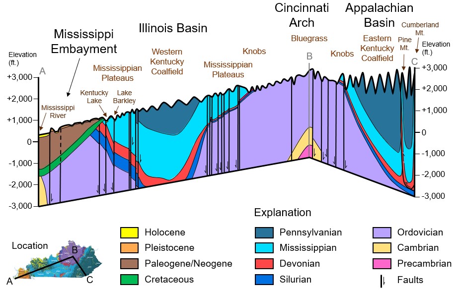
The vertical component has been stretched or vertically exaggerated in the above diagram. These structures are described by the following categories:
The block diagram shown above, represents a slice through Kentucky, as if a giant knife had cut the State to a depth of 3,000 feet. Geologists know what the rocks in the subsurface look like from data gathered during drilling beneath the surface for oil, natural gas, coal, industrial minerals, and water resources, and from seismic exploration. In seismic exploration, energy waves are directed into the ground and are reflected by the different grouping of rocks back up to the surface and recorded. Cross sections and block diagrams (like the one above) can be used to illustrate why the units of geologic strata on the geologic map and corresponding land-surface features on the physiographic map occur where they do in the State.
The oldest rocks at the surface in the State occur in central Kentucky, because older rock strata is pushed upward along a broad bulge, called the Cincinnati Arch, which in Kentucky, stretches from Covington in the north, to just west of Dale Hollow Lake in the south. Below the sedimentary rocks are igneous and metamorphic rocks. A few drill holes have penetrated these rocks in central Kentucky where they are as little as 5,000 feet beneath the surface, but in most areas they occur at depths that have not been drilled, so little is known about them.
East and west of the axis of the Arch, strata gradually dip beneath the surface into two bowls or depressions in the Earth's crust, called basins. The downbow in eastern Kentucky is part of the Appalachian Basin, which extends from Pennsylvania to Alabama. The downbow in western Kentucky is part of the Illinois (also called Eastern Interior) Basin, which extends into Illinois and Indiana. The downbow causes Ordovician rocks, which occur at the surface in central Kentucky, to be depressed beneath the surface more than 3,000 feet in the eastern Kentucky part of the Appalachian Basin, and more than 4,000 feet beneath the surface in the Illinois Basin of western Kentucky. Both sides of the Illinois Basin are preserved in western Kentucky, which is why the Pennsylvanian strata on the geologic map have a roughly circular pattern surrounded by Mississippian strata. Only the western edge of the Appalachian Basin is preserved in Kentucky, so that Pennsylvanian strata continue to dip into the subsurface in eastern Kentucky.
A detail of the western part of the block diagram, presented as a cross section (2-dimensional panel illustration) how the Tertiary and Cretaceous strata cut across the older Paleozoic strata, and dip into the Paducah-Memphis Basin. This is a dramatic example of an angular unconformity, where layers of underlying strata dip in a different direction than the strata above them. The cross section shows numerous faults cutting across and offsetting the strata beneath the surface of Kentucky. These are discussed in the section on faults.
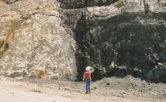
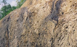
The surface traces of faults are shown as black line segments on the geologic map, and offsets along some of the major faults are shown in the block diagram. Faults represent breaks in the Earth's crust. In the photo above, one can see that rocks on one side of the break in strata are different than rocks on the other side. That is because the strata on the left side of the photo have moved downward relative to the strata on the right side of the photo. This is called a fault. Usually, movements along faults are not great at any one time. Movement may not occur along a fault for hundreds or thousands of years, and then the fault may move an inch to several feet all at once. Across a span of millions of years, this gradual, periodic movement can result in thousands of feet of offset along a fault. Most of the movement along Kentucky's faults occurred in the distant past.
When strata moves along a fault an earthquake occurs. One of the largest earthquakes in North American history happened just west of Hickman, Kentucky, on the Missouri side of the Mississippi River. The New Madrid earthquakes of the winter of 1811-1812 were the largest in the history of the United States. Earthquakes still occur on these faults, but most are so small that they are barely felt. Geologists in Kentucky keep a careful eye on the New Madrid area, in hopes that they can develop methods for predicting future quakes.
There are numerous faults in Kentucky. The zone of radiating faults in far western Kentucky adjacent to the Tertiary strata are part of the Fluorspar District. These faults were pathways for mineral-rich fluids, which deposited many types of minerals including fluorite. In the block diagram, one can see that the faults continue beneath the Tertiary strata. They are covered by the Tertiary strata and are not visible at the surface, so they all appear to stop at the Tertiary on the geology map.
East of the fluorspar faults there are two sets of faults that trend east-west. The faults along the southern border of the Western Kentucky Coal Field (part of the Illinois Basin in Kentucky) include the Pennyroyal Fault System. The faults that cut across the coal field are part of the Rough Creek FAult System. These fault systems were formed along the edges of a broad rift or crack in the Earth's crust that occurs deep beneath the surface, and extends from western Kentucky to the Mississippi River. Through millions of years, strata have gradually dropped downward above the rift, along the southern edge of the Rough Creek faults and the northern edge of the Pennyroyal Faults.
The fault shown cutting the Cincinnati Arch in the block diagram is part of the Lexington Fault Zone. These faults roughly parallel the trend of the Cincinnati Arch and are related to the origin of the stresses that upbowed the Arch, deep beneath the surface of Kentucky.
Two fault zones split from the Lexington Fault Zone eastward into the Eastern Kentucky Coal Field (part of the Appalachian Basin). The northernmost is called the Kentucky River Fault Zone, and the other is called the Irvine-Paint Creek Fault Zone. Offsets on these fault zones are mostly down to the south. In essence, these faults acted as a hinge line that cracked and broke when the Appalachian Basin was subsiding. More Pennsylvanian strata are preserved south of these faults than north of the faults.
 |
 |
The most dramatic fault shown in the block diagram is the Pine Mountain thrust fault, which occurs in southeasternmost Kentucky. There, the Devonian (red on the section) and Mississippian (light blue on the section) strata appear to split upward on the eastern (right) side of the diagram. Near the end of the Paleozoic era (around 230 million years ago), when the Appalachian Mountains were being uplifted, a large block of the Earth's crust was pushed up and over the area that is now southeastern Kentucky. The pressures from mountain building caused the northeast edge of a block of Devonian, Mississippian, and Pennsylvanian strata to be pushed upward, forming a 125-mile long ridge that we call Pine Mountain.