
The Kentucky Geological Survey has archived this material, meaning (1) it is for reference, research, or recordkeeping; (2) it was created before April 24, 2026; (3) and the material has not been changed or altered since being archived. Please refer to our KGS Accessibility page for more information.
KGS Home > Geology of Kentucky
Geologic Map of Kentucky
The map below is a geologic map of Kentucky. The geologic ages shown are periods of time when the rocks were sediments just deposited. The map shows the age of the rocks that occur at the surface (just below the soil). The geology is described by area and by geologic system or period.
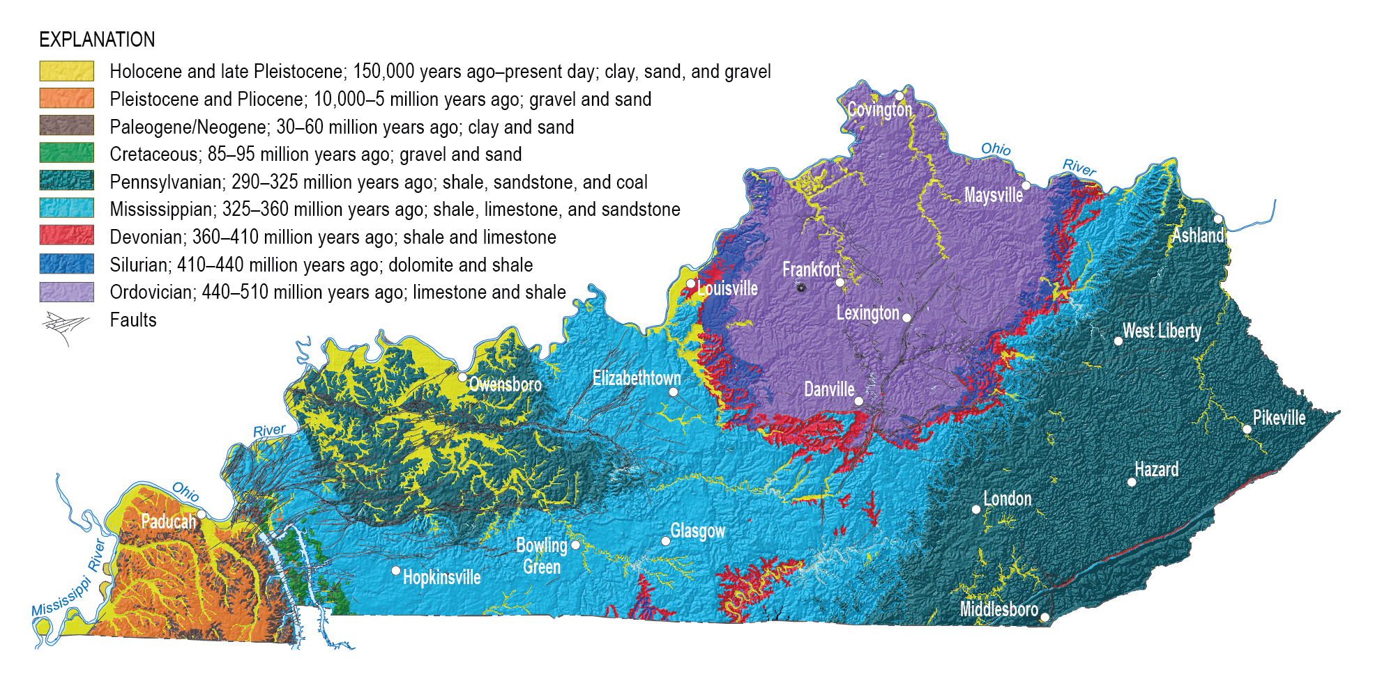
Across Kentucky, natural outcrops and man-made excavations have exposed layers of rock strata. To a geologist, these layers are like the pages in a book, and each tells a part of the geologic story of Kentucky. Almost all of the rocks exposed at the surface of the State are sedimentary rocks. Sedimentary rocks are layered, and can often be traced across broad distances at the surface and beneath the surface. Geologists can determine the relative age of sedimentary rock layers from the fossils they contain. Similar layers can be grouped into units of strata, just as pages are combined into chapters in a book. On the geologic map above, each color represents a different age, or chapter in Kentucky's geologic history. These are very large groupings of rock strata based on the geologic time scale.
Although on the map it looks as though each rock unit or chapter stops where the next begins, older units actually dip beneath younger units. So on the map above, the Ordovician strata is exposed in the center of the State, but continues beneath the surface in the areas where Silurian and Devonian (and younger) strata occur at the surface. Likewise, Ordovician through Devonian strata continue beneath the areas where Mississippian strata occur at the surface, and so on.
Each of the periods colored on the map may contain several hundred to thousands of feet of rock strata. Geologists divide these larger time-based units into smaller, mappable rock-based units called groups. Groups can be divided into smaller units called formations (each tens to hundreds of feet thick); formations may be divided into smaller units called members (usually tens of feet thick); and the smallest units are beds, which usually represent a distinctive layer of rock.
Geology through time: Choose a time period to discover where it occurs in the State, and what rocks, minerals, fossils, and economic deposits were deposited during that time period.
Beneath the Surface. Description of faults and structures beneath the surface of the State. Shoe-box Geology. Make a shoe-box model of Kentucky's surface and subsurface.
Physiography. Click on the map to learn how geology affects the topography and scenery of Kentucky.
Popular Kentucky Earth Science Publications. List of publications such as the Geologic Story of Kentucky by Preston McGrain, which can be ordered from the Kentucky Geological Survey.